Showing 1117 items matching "land development"
-
 Whitehorse Historical Society Inc.
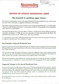
Document - Pamphlet, Review of special residential zone, 1973
... Mitcham melbourne residential development land use city ...City of Nunawading: review of special residential zone: seeking exemptions from residents on existing zone provisions 1973residential development, land use, city of nunawading, laburnum street, blackburn, the avenue, fuschia street, myrtle grove, linum street, acacia avenue, laurel grove, boongarry avenue, main street, gardiner street, blackburn road, jeffery street, naughton grove, special residential zone -
 Lakes Entrance Historical Society
Book, Tract Consultants Australia Pty Ltd, Storth Ryes Enviornment Effects Statement, 1988
... Land Settlement Commercial Development Environment effects ...Environment effects statement, Supplementary Report on the proposed Storth Ryes, Metung, Victoria, residential and resort development on the Gippsland Lakes. Includes concept plans and sketches.land settlement, commercial development -
 Greensborough Historical Society
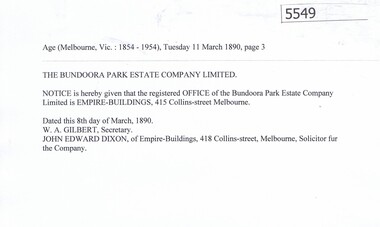
Article, Bundoora Park Estate Company, 1890-1894
... land development speculative companies operating... Limited was one of the many land development speculative companies ...Bundoora Park Estate Company Limited was one of the many land development speculative companies operating in the Greensborough area in the 1890s. 5 p. of transcripts of five newspaper articles bundoora park estate campany limited, bundoora -
Port Melbourne Historical & Preservation Society
Booklet, Framework for the Future, Dec 1984
... , Land Use and Development Strategy for the 1980s...: Framework for the Future No 6, Land Use and Development Strategy ...found in the Mayor's room at Port Melbourne Town Hall by Pat Grainger on the coffee table.Victoria - Central Melbourne: Framework for the Future No 6, Land Use and Development Strategy for the 1980stown planning -
 Whitehorse Historical Society Inc.
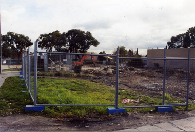
Photograph, Colombo Street Mitcham, 2006
... Coloured photo of land for proposed development... Coloured photo of land for proposed development of a fourteen ...Coloured photo of land for proposed development of a fourteen storey apartment block in Colombo Street, Mitchamcolombo street mitcham, high-rise buildings -
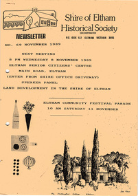 Eltham District Historical Society Inc
Newsletter, Newsletter, No. 69 November 1989
... Contents: • Next meeting, Speaker Panel: Land Development...Contents: • Next meeting, Speaker Panel: Land Development ...Contents: • Next meeting, Speaker Panel: Land Development in the Shire of Eltham • November Meeting • Recent Activities • Eltham Community Festival • Flavour of Eltham • Other Things You Should Know The Shire of Eltham Historical Society was formed in October 1967. The first newsletter of the Society was issued May 1978 and has been published continuously ever since on a bi-monthly basis. With the cessation of the Shire of Eltham in late 1994, the Society's name was revised to Eltham District Historical Society and this name first appeared with issue No. 103, July 1995. The collection of the Society's newsletters provides a valuable resource on the history of the Society's activities, office bearers and committee members, guest speakers and subjects of historical interest pertinent to the former Shire of Eltham and the Eltham District.A4 photocopied newsletter distributed to membersnewsletter, eltham district historical society, shire of eltham historical society -
Glen Eira Historical Society
Document - KAMBROOK ROAD, 46, CAULFIELD NORTH
... of the origins of Caulfield Racecourse and land development by 1917... history of the origins of Caulfield Racecourse and land ...A copy of a one page typed report by Hilary Bullock and Rosalind Landells of the Brighton Historical Society, dated 14/10/1995, with handwritten notes about this property. It covers the owners of this address from 1918 to 1994 and a short history of the origins of Caulfield Racecourse and land development by 1917. It also mentions the first meeting of the Caulfield Amateur Turf Club in 1859.caulfield north, kambrook road, caulfield cup, caulfield racecourse, racecourses, caulfield amateur turf club, 'kambrook', payne john, balaclava road, swan william h, urquhard john, wenn john, reddon george, may phillip g, griffin g mrs, newton g t (horse trainer), bullock hilary, landells rosalind, bick david, foote henry (surveyor), caulfield roads board, glen eira road, land subdivision -
 Whitehorse Historical Society Inc.
Photograph, Colombo Street, Mitcham, 2006
... Coloured photo of land for proposed development... Mitcham melbourne Development of fourteen story apartment block ...Development of fourteen story apartment block. Given a permit in 2004. Permit not extended on 2007.Coloured photo of land for proposed development of a fourteen storey apartment block in Colombo Street, Mitcham (previously site of Brewer Sporting Goods Manufacturing Goods Factory)colombo street mitcham, high-rise buildings -
 Flagstaff Hill Maritime Museum and Village
Photograph - Historical, Flagstaff Hill, John Lindsay, View of the Bay from the south boundary of the Ports and Harbours land, 1970s
... boundary of the Ports and Harbours land. No development below... and Harbours land. No development below this area is likely to obstruct ...The photograph shows the view of the shore and Lady Bay with the Breakwater and Middle Island all visible. It was taken to show that the Flagstaff Hill area was unlikely to have any further development between it and the Bay, with the view of development of the Flagstaff Hill Maritime Museum and Village. This photograph, a print, is one of a set of five that show the site of Flagstaff Hill. The photographer was John Lindsay, Founding Director of Flagstaff Hill Maritime Museum and Village, with the words "Photo J Lindsay" on the back. It was taken in the early 1970s during the initial stages of the development of Flagstaff Hill as a Museum and Maritime Village. The photographs belonged to the donor's grandparents, who lived in the Warrnambool district of Allansford/Naringal. The photograph is a record of the site and surrounds of Flagstaff Hill Maritime Museum and Village before its development and opening in 1975. It shows the Surfside Holiday Park, Surf Lifesaving Club, and the Breakwater. The photograph is significant for recording the location and condition of the Lower Lighthouse on the Hill.Coloured photograph, glassy print, one of a set of five. Flagstaff Hill's Lower Lighthouse is in the foreground above the Surfside Holiday Park. To the right of centre is the Surf Lifesaving Club. In the background is Lady Bay and the Breakwater and Middle Island, with the Southern Ocean the other side. The photograph's paper has the printer's watermark and a pencilled inscription on the back. The early 1970s scene was photographed by John Lindsay, Warrnambool.Label on the back: "VIEW OF THE BAY FROM the southern boundary of the Ports and Harbours land. No development below this area is likely to obstruct the view, due to the steep grade down to the Southern boundary of Flagstaff Hill property." Handwritten in pencil: "Photo J Lindsay"flagstaff hill, flagstaff hill maritime museum and village, warrnambool, maritime museum, maritime village, great ocean road, shipwreck coast, 1970s, photograph, surfside holiday park, lady bay, flagstaff hill site, john lindsay, lower lighthouse, lower light, surf lifesaving club, breakwater, middle island, ports and harbours -
 Ringwood and District Historical Society
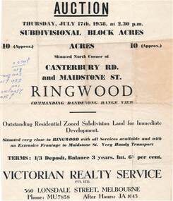
Flyer - Land Auction Sale, Ten Acres, Maidstone Street Ringwood - 1958
... Residential zoned subdivision land for immediate...Residential zoned subdivision land for immediate ...Double sided page advertising Auction, Thursday, July 17th, 1958, (Approx.) 10 Acres, north corner of Canterbury Road and Maidstone Street, Ringwood. Agents - Victorian Realty Service Pty.Ltd., 360 Lonsdale Street, Melbourne, Phone MU7858, After Hours JA1045. Reverse side shows map of proposed subdivision by K.J. Noonan & Co., Surveyors & Engineers, 495 St.Kilda Rd, Melbourne, marked subject to approval of all interested statutory authorities.Residential zoned subdivision land for immediate development. Extensive frontage to Maidstone Street. Accompanying handwritten annotation "10 acres offered as a whole, later re-subdivided". -
Glenelg Shire Council Cultural Collection
Photograph - Photograph - Aerial view of the Port of Portland from the south-west, c. 1967
... the S.W. K.S.Anderson wharf, silos and reclaimed land prepared.... K.S.Anderson wharf, silos and reclaimed land prepared for further ...Port of Portland Authority archives.Front: (no inscriptions) Back: Area available for silo extension and storageport of portland archives -
 Greensborough Historical Society
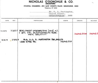
Legal record - Account, Nicholas O'Donohue & Co, Nicholas O'Donohue & Co to Partington 1971, 12/07/1971
... A solicitor's account to Alan Partington following a land... Partington following a land transaction with Development Underwriting ...A solicitor's account to Alan Partington following a land transaction with Development Underwriting Vic. P/L in 1971. Part of many land deals made by the Partington family in the sale of the original Greensborough farmland.Solicitor's account, black text on white paperalan partington, william alan partington, partington family, land deals greensborough, nullarbor -
 Whitehorse Historical Society Inc.
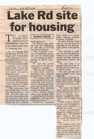
Article, Lake Rd Site for Housing, 8/04/1992 12:00:00 AM
... with the proposed development of land on the former Forest Hill Residential... Mitcham melbourne land subdivision forest hill residential ...Lake Rd Site for Housing.An article in the Nunawading Gazette on an objection by Mark Delaney on the traffic flow and hazards associated with the proposed development of land on the former Forest Hill Residential Kindergarten land.Lake Rd Site for Housing.land subdivision, forest hill residential kindergarten, lake road, forest hill, jean street, phillips, bruce, delaney, mark, glen valley road -
Ringwood and District Historical Society
Newspaper Cutting, The Sun, Ringwood Development article (Sun Newspaper) 23 Aug 1960, 23-Aug-60
... Article about land 'frieze' of the 16 acres of land...' of the 16 acres of land for the proposed development site ...Article about land 'frieze' of the 16 acres of land for the proposed development site for Eastland.Article about Ringwood development in Sun newspaper. Double page. +Additional Keywords: Lavis, A.G., Mayor / Dwerryhouse, F.P., Town ClerkLand 'Frieze' at Ringwood. -
Whitehorse Historical Society Inc.
Pamphlet, City of Nunawading land use statement, 1994
... A draft statement from City of Nunawading on land use... directions & priorities for land use change and development within ...A draft statement from City of Nunawading on land use strategy to establish directions & priorities for land use change and development within the municipality for the remainder of this decade and into the next. Council seeking comments.land use, city of nunawading -
 Greensborough Historical Society
Plan, Plan of Manatunga Circuit Greensborough subdivision, 1970_
... and Beveridge (land surveyors) for Development Underwriting (developers... subdivision. Prepared by O'Connor and Beveridge (land surveyors ...Plan of Manatunga Circuit subdivision. Prepared by O'Connor and Beveridge (land surveyors) for Development Underwriting (developers). Plan of subdivision. Part of Crown Portion 3. Parish of Nillumbik, County of Evelyn.An original example of a subdivision plan in the expanding suburb of Greensborough. The 1960s and 1970s saw this area develop from a rural farming area to a suburb.Plan of subdivision. Printed on buff paper, hand coloured. Mounted on cardboard. Includes 2 small cards attached.Various handwritten comments. Small cards from Survey Branch, Office of Titles.greensborough, manatunga circuit, diamond creek road, plenty river drive -
![Document, Town Planning Appeals Tribunal, Town Planning Appeals Tribunal report 1978 [Loyola College], 06/11/1978](/media/collectors/4f729f5697f83e03086015b8/items/58bbb237d0cdef1bcc864955/item-media/58bbb35fd0cdef1bcc8683be/item-fit-380x285.jpg) Greensborough Historical Society
Greensborough Historical SocietyDocument, Town Planning Appeals Tribunal, Town Planning Appeals Tribunal report 1978 [Loyola College], 06/11/1978
... on the development of land in Grimshaw Street Watsonia for a secondary school... conditions on the development of land in Grimshaw Street Watsonia ...Report on an appeal against two conditions on the development of land in Grimshaw Street Watsonia for a secondary school [Loyola College].This document demonstrates some of the problems associated with setting up a school in a residential area.3 pages, torn and yellowed.loyola college -
 City of Moorabbin Historical Society (Operating the Box Cottage Museum)
Flyer - Smith's Estate, Highett
... opened up the land for housing development. The section bounded... the land for housing development. The section bounded by Peterson ...The train line from the city to Mordialloc was built which opened up the land for housing development. The section bounded by Peterson Street Telford Street and Highett Road is now Peterson Street Reserve.Example of the progress of the Municipality of MoorabbinAdvertising flyer for auction of real estate sales - plan of building blocks for saleSmith's Estate, Highett - J. F. Bradyhighett, real estate, highett road, hillside street (no longer exists), peterson st, frederico st, tolhurst st (no longer exists), wickham road, danson street, peterson street reserve -
Whitehorse Historical Society Inc.
Article, Development threatens to bury famous artistic site, 2006
... Government to stop development on land where Frederick McCubbin... to stop development on land where Frederick McCubbin painted his ...Residents have made a last-ditch call for the Federal Government to stop development on land where Frederick McCubbin painted his famous work 'Bush Burial' in 1890Residents have made a last-ditch call for the Federal Government to stop development on land where Frederick McCubbin painted his famous work 'Bush Burial' in 1890 (Photo of painting plus David McCubbin)Residents have made a last-ditch call for the Federal Government to stop development on land where Frederick McCubbin painted his famous work 'Bush Burial' in 1890blackburn lake sanctuary, mccubbin, frederick, mccubbin, david, wolseley crescent, blackburn, blackburn lake environmental education park committee, city of whitehorse, seventh day adventist church nunawading -
 Ballarat Tramway Museum
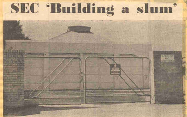
Newspaper, The Courier Ballarat, "SEC 'Building a slum' ", 20/02/1972 12:00:00 AM
... depot land to development comprising 16 houses as a built... depot land to development comprising 16 houses as a built ...Newspaper clipping from The Courier, Ballarat, dated Monday 20/3/1972, titled "SEC 'Building a slum' ". Item with a photo about the proposals of the SEC to convert the former tram depot land to development comprising 16 houses as a built-in slum. The development was considered inappropriate for the area by local residents, who requested a development of 6 lots. Features a photo of the depot building with locked gates and a Security company sign on the gate. One of large group of newspaper cuttings from John Bainbridge, 7/4/02.depot, sale of land, wendouree parade -
 Bendigo Historical Society Inc.
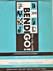
Document - AULSEBROOK COLLECTION: BENDIGO PROMOTIONAL BOOKLET
... information on what Bendigo has to offer such as; future developments... on what Bendigo has to offer such as; future developments ...Aulsebrook Collection: The City with BendiGO, promotional booklet -10pages -Blue, brown and white themed -Covers basic information on what Bendigo has to offer such as; future developments, transport, land, education, commerce, sport, tourist attractions and more. -
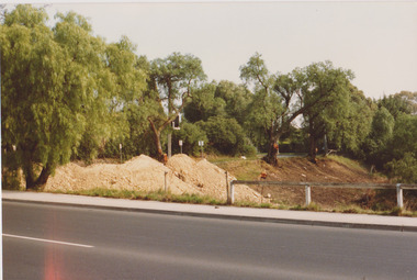
 Darebin Parklands Association
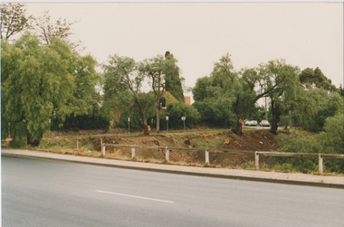
Arbour Street May 1987, Darebin Parklands Association, 1987
... Colour photograph. Preparing for development of land... for development of land. This item and all other Darebin Parklands ...Colour photograph. Preparing for development of land. This item and all other Darebin Parklands Association archival material is now held by State Library Victoria (Accession No: YMS 13746). Please contact State Library Victoria if access is required.Annotated on back. -
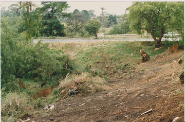
 Darebin Parklands Association
Arbour Street 17th April 1987, Darebin Parklands Association, 1987
... Colour photograph. Preparing for the development of land... for the development of land. This item and all other Darebin Parklands ...Colour photograph. Preparing for the development of land. This item and all other Darebin Parklands Association archival material is now held by State Library Victoria (Accession No: YMS 13746). Please contact State Library Victoria if access is required.Annotated on back. -
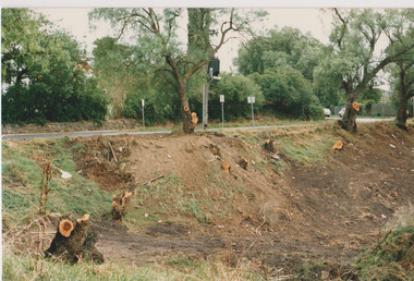
 Darebin Parklands Association
Arbour Street May 1987, Darebin Parklands Association, 1987
... Colour photograph. Preparing for development of land... for development of land. This item and all other Darebin Parklands ...Colour photograph. Preparing for development of land. This item and all other Darebin Parklands Association archival material is now held by State Library Victoria (Accession No: YMS 13746). Please contact State Library Victoria if access is required.Annotated on back. -
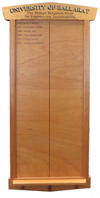 Federation University Historical Collection
Honour Board, The Pitman Benjamin Prize for Engineering Sustainability Honour Board, c2006
... of Melbourne. In 2002 Heather Pitman was Land Development Engineer... of Melbourne. In 2002 Heather Pitman was Land Development Engineer ...The Pitman Benjamin Prize for Engineering Sustainability is awarded to the Civil Engineering student whose thesis best promotes sustainable engineering. It is awarded in memory of a Heather Pitman, the first woman to graduate in Engineering at Ballarat. The Pitman Benjamin Prize for Engineering Sustainability is sponsored by Benjamin Real Estate, and was first awarded in 2006. Heather was the first female graduate from Ballarat College of Advanced Education and obtained outstanding results. Throughout her career she worked predominantly in local government and for much of that time with the Shire of Ballarat, then the City of Ballarat. During that time she worked as a civil engineer and in planning. Heather was a trail blazer in many respects and was one of the first women to be employed into an engineering position at that time. It was not easy, and she applied for about 200 jobs before being employed by the Shire of Greensborough, north of Melbourne. In 2002 Heather Pitman was Land Development Engineer with the City of Ballarat. The following year she was the City of Ballarat's Manager, Building & Assets. Award sponsor Terry Benjamin was a great mentor of Heather’s sponsoring the award in her memory when she died suddenly at the age of 48. Honour Board, gold lettering University of Ballarat. Black lettering The Pitman Benjamin Prize for Engineering Sustainability. The Pitman Benjamin Prize for Engineering Sustainability has been awarded to: * 2006 - Nathan Whittle; * 2007 - Christopher Quinn; * 2008 - Vinoch Ravi; * 2009 - Troy Vanberkel; * 2010 - Nil; * 2011 - Craig Furniss; * 2012 - Joshua Handreck; * 2013 - Matthew Willis (not on board 10/6/2014); * 2013 - Daniel Camilleri (not on board 10/6/2014);pitman benjamin, nathan whittle, christopher quinn, vinodh ravi, troy vanberkel, craig furniss, joshua handreck, prize, engineering, sustainability, heather pitman, stuart benjamin, benjamin real estate -
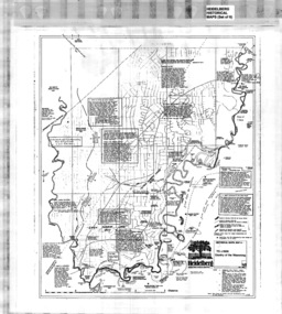 Greensborough Historical Society
Map, Heidelberg: Historic River Landscape Assessment, Historical Maps. Map A To 1838. Country of the Wawarang, 1985c
... and comments on the land and its development. Bounded by Shire..., descriptions and comments on the land and its development. Bounded ...Geographical area of around 35 sq. kilometres marked with physical features such as major roads, rivers, vegetation and properties, with contemporary notes on landowners, descriptions and comments on the land and its development. Bounded by Shire of Diamond Valley to the North, Darebin Creek to the West and Plenty River to the East.Black an white sketch map on white paperheidelberg, heidelberg - maps -
 Greensborough Historical Society
Map, Heidelberg: Historic River Landscape Assessment. Historical Maps. Map B 1838-1851, "The Distinctly aristocratic locality", 1985c
... and comments on the land and its development. Bounded by Shire..., descriptions and comments on the land and its development. Bounded ...Geographical area of around 35 sq. kilometres marked with physical features such as major roads, rivers, vegetation and properties, with contemporary notes on landowners, descriptions and comments on the land and its development. Bounded by Shire of Diamond Valley to the North, Darebin Creek to the West and Plenty River to the EastBlack and white sketch map on white paperheidelberg, heidelberg - maps -
 Greensborough Historical Society
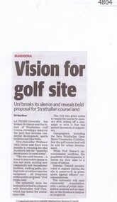
Newspaper Clipping, Diamond Valley Leader, Vision for golf site, 02/08/2017
... of Strathallan Golf Course, revealing a vision for the land that includes... a vision for the land that includes residential development, sports ...La Trobe University has broken its silence over the future of Strathallan Golf Course, revealing a vision for the land that includes residential development, sports facilities and bike trails.News article 1 page, black text.strathallan golf club, la trobe university, darebin council, bundoora -
 Bendigo Historical Society Inc.
Document - NORMAN OLIVER COLLECTION: SPEECH NOTES 1949-1971
... development, land reclamation, garbage collection, soldier employment... development, land reclamation, garbage collection, soldier employment ...The Norman Oliver collection. Norman Oliver was three times Mayor of Bendigo - 1950-51, 1964-65, 1970-71. Fourteen pages of typed notes, untitled and undated. Additions and corrections in blue ink. Introduction suggests that this is first report and the beginning of his 3BO 'The Mayor Speaks'. Topics include : sewerage development, land reclamation, garbage collection, soldier employment preference, finance, and social events.bendigo, council, speech notes, norman joseph oliver , councillor norman oliver. mayor of bendigo. 3bo 'the mayor speaks'.