Showing 416 items matching "land settlement"
-
 Lakes Entrance Historical Society
Map - Inceecoobee County of Tambo, Department of Lands and Survey, 7/6/2016
... Land Settlement...Lakes Entrance Historical Society 4 Marine Parade Lakes Entrance gippsland Land Settlement Waterways Snowy River, Land owners E A Comors, C H Rogers, Tooncinbooka Map Inceecoobee County of Tambo Department of Lands and Survey ...Snowy River, Land owners E A Comors, C H Rogers, Tooncinbookaland settlement, waterways -
Lakes Entrance Historical Society
Map - Bingo-Munjie County of Bogong, Dept of Lands and Survey
... Land Settlement...Lakes Entrance Historical Society 4 Marine Parade Lakes Entrance gippsland Land Settlement Shows landowners of Coloungra, OImeo, Bingo-Munjie South. ...Shows landowners of Coloungra, OImeo, Bingo-Munjie South. Bingo-Munjie South insert diagram showing Triangulation of Parishland settlement -
Lakes Entrance Historical Society
Map - Thorkidaan Counties of Tambo and Benambra, Dept of Lands and Survey
... Land Settlement...Lakes Entrance Historical Society 4 Marine Parade Lakes Entrance gippsland Land Settlement Forest Shows Hinno-Munjie, Cuttamurra. ...Shows Hinno-Munjie, Cuttamurra. Euccmbene, Tambo, County of Dargo. Moonip, Reserved forest, Benambra land ownersland settlement, forest -
Lakes Entrance Historical Society
Map - Boorolite County of Wonnangatta, AC Brooks Gov. Printer
... Land Settlement...Lakes Entrance Historical Society 4 Marine Parade Lakes Entrance gippsland Land Settlement Waterways Shows land owners County of Delatite, Changue, Howgua, Howgua River, Timbertop Creek Map Boorolite County of Wonnangatta AC Brooks Gov. ...Shows land owners County of Delatite, Changue, Howgua, Howgua River, Timbertop Creekland settlement, waterways -
Lakes Entrance Historical Society
Map - Tambo Counties of Dargo and Tambo
... Land Settlement...Lakes Entrance Historical Society 4 Marine Parade Lakes Entrance gippsland Land Settlement Forest Townships Land owners, reserved forest Dargo, Township of Bruthen, Sarsfield, Colquhoun North, Bummberah. 2 pages A nd B Map Tambo Counties of Dargo and Tambo ...Land owners, reserved forest Dargo, Township of Bruthen, Sarsfield, Colquhoun North, Bummberah. 2 pages A nd Bland settlement, forest, townships -
Lakes Entrance Historical Society
Map - Benambra, Dept of Lands and Survey
... Land Settlement...Lakes Entrance Historical Society 4 Marine Parade Lakes Entrance gippsland Land Settlement Waterways Forest County Northern Section Sheet 1 Shows Indi River, Murray River showing agricultural and grazing land, pastural land, swamp land, State forests, Timber reserves. ...Shows Indi River, Murray River showing agricultural and grazing land, pastural land, swamp land, State forests, Timber reserves.County Northern Section Sheet 1land settlement, waterways, forest -
Lakes Entrance Historical Society
Map - Dargo, Dept of Lands and Survey
... Land Settlement...Lakes Entrance Historical Society 4 Marine Parade Lakes Entrance gippsland Land Settlement Waterways Shows areas from Benambra, Bongong to Tanjil, Wongurra River Map Dargo Dept of Lands and Survey ...Shows areas from Benambra, Bongong to Tanjil, Wongurra Riverland settlement, waterways -
Lakes Entrance Historical Society
Map - Tambo Counties of Dargo and Tambo, A C Brooks Gov. Printer
... ...Land Settlement...Lakes Entrance Historical Society 4 Marine Parade Lakes Entrance gippsland Townships Roads and Streets Land Settlement Waterways Shows townships of Bruthen, Dargo, Tambo River, Omeo Highway, Land owners Map Tambo Counties of Dargo and Tambo A C Brooks Gov. ...Shows townships of Bruthen, Dargo, Tambo River, Omeo Highway, Land ownerstownships, roads and streets, land settlement, waterways -
 Lakes Entrance Historical Society
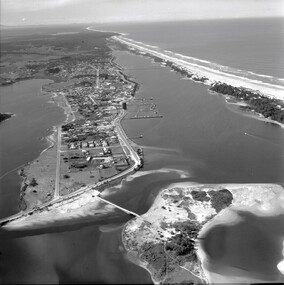
Photograph - Aerial view of Lakes Entrance c1950's, c1950
... ...Land settlement...Lakes Entrance Historical Society 4 Marine Parade Lakes Entrance gippsland pre development on Bullock Island Waterways Land settlement Hotels Black and white aerial photograph showing the western end of Lakes Entrance , pre development of Bullock Island Photograph Aerial view of Lakes Entrance c1950's ...pre development on Bullock Island Black and white aerial photograph showing the western end of Lakes Entrance , pre development of Bullock Islandwaterways, land settlement, hotels -
 Lakes Entrance Historical Society
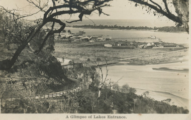
Postcard - Club Hotel from Jemmy's Point
... Land Settlement...Lakes Entrance Historical Society 4 Marine Parade Lakes Entrance gippsland Land Settlement Towns Roads and Streets A Glimpse of Lakes Entrance Black and white postcard of the Club Hotel from Jemmy's Point Postcard Club Hotel from Jemmy's Point ...Black and white postcard of the Club Hotel from Jemmy's PointA Glimpse of Lakes Entranceland settlement, towns, roads and streets -
Lakes Entrance Historical Society
Map - Boole Poole County of Tanjil, Dept of Lands and Survey, 1965
... ...Land settlement...Lakes Entrance Historical Society 4 Marine Parade Lakes Entrance gippsland landowners Waterways Parks Land settlement Shows landowners named on Boole Poole. ...Shows landowners named on Boole Poole. The Lakes National Park, Sperm Whale Head, Lake Victoria, Seacombe. 2 pages A and B and four photocopies.landowners, waterways, parks, land settlement -
Lakes Entrance Historical Society
Map - Seacombe Counties of Buln Buln and Tanjil
... Land Settlement...Lakes Entrance Historical Society 4 Marine Parade Lakes Entrance gippsland Land Settlement Waterways Shows landowners, Lake Reeve, Boole Poole, Lake Victoria, Reedy Point, Benworden South, Lake Wellington, Bass Strait. ...Shows landowners, Lake Reeve, Boole Poole, Lake Victoria, Reedy Point, Benworden South, Lake Wellington, Bass Strait.land settlement, waterways -
Lakes Entrance Historical Society
Map - Seacombe Counties of Buln Buln and Tanjil
... Land Settlement...Lakes Entrance Historical Society 4 Marine Parade Lakes Entrance gippsland Land Settlement Waterways Shows landowners, Bass Strait, Benworden South, Lake Victoria, Booran, County of Buln Buln Map Seacombe Counties of Buln Buln and Tanjil ...Shows landowners, Bass Strait, Benworden South, Lake Victoria, Booran, County of Buln Bulnland settlement, waterways -
 Lakes Entrance Historical Society
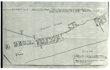
Photograph - New Works Plan, 1898
... Land Settlement...Scale two chains to one inch. ( A photocopy of this map in Latrobe Library map collection, June 1983) Land Settlement Plan Black and white photograph showing sketch map of 1898 by John Lardner Plan of Sites - sand hummocks. ...Map traced from a photocopy of :- Map TP8A Bairnsdale. 'Site. Sand Hummocks of Lakes Entrance'. Drawn by John Lardner 18 January 1898. Scale two chains to one inch. ( A photocopy of this map in Latrobe Library map collection, June 1983)Black and white photograph showing sketch map of 1898 by John Lardner Plan of Sites - sand hummocks. Drawing shows sites of buildings at entrance along Cunninghame Arm shoreline at Lakes Entrance, Victoria.land settlement, plan -
 Lakes Entrance Historical Society
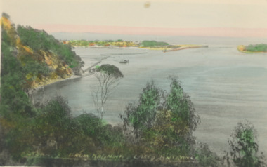
Postcard - New Works Lakes Entrance
... ...Land Settlement...Lakes Entrance Historical Society 4 Marine Parade Lakes Entrance gippsland view of the entrance at Lakes Entrancesize Waterways Topography Land Settlement The Entrance Lakes Entrance Victoria Colour tinted postcard showing view of the entrance at Lakes Entrance New Works Lakes Entrance Postcard New Works Lakes Entrance ...view of the entrance at Lakes EntrancesizeColour tinted postcard showing view of the entrance at Lakes EntranceThe Entrance Lakes Entrance Victoriawaterways, topography, land settlement -
Lakes Entrance Historical Society
Book, George Dunderdale, The Book of The Bush by George Dunderdale, 1867
... ...Land Settlement...Lakes Entrance Historical Society 4 Marine Parade Lakes Entrance gippsland Pioneers Land Settlement Aboriginals Law and order Social History True stories of the many facets of early colonial life written by a Government officer who saw highs and lows of society at this turbulent time 820 pages The Book of The Bush by George Dunderdale Book George Dunderdale ...True stories of the many facets of early colonial life written by a Government officer who saw highs and lows of society at this turbulent time820 pagesnon-fictionTrue stories of the many facets of early colonial life written by a Government officer who saw highs and lows of society at this turbulent time pioneers, land settlement, aboriginals, law and order, social history -
Lakes Entrance Historical Society
Book, H.J.Malone, A Short History of Central South Gippsland, 12.11.1932
... ...Land settlement...Lakes Entrance Historical Society 4 Marine Parade Lakes Entrance gippsland A record of discovery, exploration and development of Central South Gippsland from aboriginal tribes to townships and industry in the 20th Century Exploration Aboriginals Land settlement A record of discovery, exploration and development of Central South Gippsland from aboriginal tribes to townships and industry in the 20th Century 76 pages A Short History of Central South Gippsland Book H.J.Malone ...A record of discovery, exploration and development of Central South Gippsland from aboriginal tribes to townships and industry in the 20th Century76 pages non-fictionA record of discovery, exploration and development of Central South Gippsland from aboriginal tribes to townships and industry in the 20th Centuryexploration, aboriginals, land settlement -
Lakes Entrance Historical Society
Book, Coral Dow, Tatungalung Country by Coral Dow, June 2004
... ...Land Settlement...Lakes Entrance Historical Society 4 Marine Parade Lakes Entrance gippsland Fishing Land Settlement Aboriginals Environment Guesthouses Boats A comprehensive study of the Gippsland Lakes area told in text, maps and illustrations An Environmental History of the Gippsland Lakes Spiral bound book 82 pages Tatungalung Country by Coral Dow Book Coral Dow ...A comprehensive study of the Gippsland Lakes area told in text, maps and illustrationsSpiral bound book 82 pagesnon-fictionA comprehensive study of the Gippsland Lakes area told in text, maps and illustrationsfishing, land settlement, aboriginals, environment, guesthouses, boats -
Lakes Entrance Historical Society
Map - Title for Allottments at Lakes Entrance 1885, Mason Firth & McCutchern, 1885
... Land Settlement...Lakes Entrance Historical Society 4 Marine Parade Lakes Entrance gippsland Land Settlement Township Regulations For Sale Auction Wednesday January 1885 by Gemmell Tuckett & Co. ...Title of 49 allottments at Lakes Entrance Gippssland.For Sale Auction Wednesday January 1885 by Gemmell Tuckett & Co.land settlement, township, regulations -
 Lakes Entrance Historical Society
Photograph - Lake Tyers Aboriginal Trust Lake Tyers Victoria, 1/08/2008 12:00:00 AM
... ...Land Settlement...This photograph was taken at the time of 150 years Lakes Entrance 1858 to 2008 display held in 2008 Aboriginals Land Settlement Events Houses Colour photograph of houses on Rules Road at the Lake Tyers Aboriginal Trust Lake Tyers Victoria. plus 2 other photos of the Lake Tyers Aboriginal Trust Lake Tyers Victoria. ...Rules Road at the Lake Tyers Aboriginal Trust Lake Tyers Victoria. This photograph was taken at the time of 150 years Lakes Entrance 1858 to 2008 display held in 2008Colour photograph of houses on Rules Road at the Lake Tyers Aboriginal Trust Lake Tyers Victoria. plus 2 other photos of the Lake Tyers Aboriginal Trust Lake Tyers Victoria.aboriginals, land settlement, events, houses -
Lakes Entrance Historical Society
Book, Adams John, The Tambo Shire Centenary History, 1981
... Land Settlement...Lakes Entrance Historical Society 4 Marine Parade Lakes Entrance gippsland A history of the Shire of Tambo, East Gippsland, Victoria, including many aspects of settlement, development, industries, transport, and the hardy people who tamed this varied and often inhospitable region. Land Settlement Transport A history of the Shire of Tambo, East Gippsland, Victoria, including many aspects of settlement, development, industries, transport, and the hardy people who tamed this varied and often inhospitable region. ...A history of the Shire of Tambo, East Gippsland, Victoria, including many aspects of settlement, development, industries, transport, and the hardy people who tamed this varied and often inhospitable region.A history of the Shire of Tambo, East Gippsland, Victoria, including many aspects of settlement, development, industries, transport, and the hardy people who tamed this varied and often inhospitable region.land settlement, transport -
Lakes Entrance Historical Society
Book, Morrissey D W and Morrissey E W, Lakes Entrance a Short History and Tourist Guide
... ... Land Settlement...A short history of lakes Entrance from early settlement, including references to forest survey, land sales, shipping, fishing industry and development of the town and tourist industry ...A short history of lakes Entrance from early settlement, including references to forest survey, land sales, shipping, fishing industry and development of the town and tourist industry...Lakes Entrance Historical Society 4 Marine Parade Lakes Entrance gippsland A short history of lakes Entrance from early settlement, including references to forest survey, land sales, shipping, fishing industry and development of the town and tourist industry Settlers Land Settlement A short history of lakes Entrance from early settlement, including references to forest survey, land sales, shipping, fishing industry and development of the town and tourist industry Lakes Entrance a Short History and Tourist Guide Book Morrissey D W and Morrissey E W ...A short history of lakes Entrance from early settlement, including references to forest survey, land sales, shipping, fishing industry and development of the town and tourist industry A short history of lakes Entrance from early settlement, including references to forest survey, land sales, shipping, fishing industry and development of the town and tourist industrysettlers, land settlement -
Lakes Entrance Historical Society
Book, Morrissey, D.W and Morrissey E.W, Lakes Entrance a Short History revised Edition, 1980
... Land Settlement...Local school Land Settlement Religion Aboriginals Margaret Campbell'' History of Koorie inhabitants through to fishing industry, timber industry, early settlers and survey and sale of land. ...History of Koorie inhabitants through to fishing industry, timber industry, early settlers and survey and sale of land. The opening of the entrance to allow shipping industry to operate bringing much trade and movement of primary produce etc. Local schoolHistory of Koorie inhabitants through to fishing industry, timber industry, early settlers and survey and sale of land. The opening of the entrance to allow shipping industry to operate bringing much trade and movement of primary produce etc. Local schoolMargaret Campbell''land settlement, religion, aboriginals -
Lakes Entrance Historical Society
Book, Alison Goding, This Bold Venture the story of Lake Tyers House Place and People, 1990
... ... Land Settlement...Lakes Entrance Historical Society 4 Marine Parade Lakes Entrance gippsland Guesthouses Waterways Land Settlement The story of Lake Tyers House, situated on Lake Tyers, Victoria, and the people associated with this early tourism venture. ...The story of Lake Tyers House, situated on Lake Tyers, Victoria, and the people associated with this early tourism venture. The settlement and development of the region is also dealt with and photographs are included.guesthouses, waterways, land settlement -
Lakes Entrance Historical Society
Book, Past Pictures and Poems of East Gippsland, 1993
... ... Land Settlement...Lakes Entrance Historical Society 4 Marine Parade Lakes Entrance gippsland Celebrations Land Settlement Township An anthology of poems by local people, illustrated with photographs, compiled for the 'Back to Bairnsdale' celebrations in 1993. ...An anthology of poems by local people, illustrated with photographs, compiled for the 'Back to Bairnsdale' celebrations in 1993. Facts are not resourced, captions are known to be suspect.celebrations, land settlement, township -
Lakes Entrance Historical Society
Book, Fairweather, Keith Mc D, Brajerack - Mining at Omeo and Glen Wills
... ... Land Settlement...Lakes Entrance Historical Society 4 Marine Parade Lakes Entrance gippsland Aboriginals Mines and Mining Land Settlement Ruth Clark A Description of the mining industry in the northern part of of the Shire of Omeo, Victoria,dealing with the settlements of Omeo, Glen Wills, Sunnyside, Saltpetre Creek and Wombat, also Cobungra River and Newrush Creek. ...A Description of the mining industry in the northern part of of the Shire of Omeo, Victoria,dealing with the settlements of Omeo, Glen Wills, Sunnyside, Saltpetre Creek and Wombat, also Cobungra River and Newrush Creek. Aboriginal identities IllustratedRuth Clarkaboriginals, mines and mining, land settlement -
Lakes Entrance Historical Society
Book, Meridith Fletcher, Gippsland Heritage Journal, 1996
... ... Land Settlement...Lakes Entrance Historical Society 4 Marine Parade Lakes Entrance gippsland Agriculture Land Settlement Migrants Life in various areas around Gippsland Victoria Gippsland Heritage Journal Book Meridith Fletcher ...Life in various areas around Gippsland Victoriaagriculture, land settlement, migrants -
 Lakes Entrance Historical Society
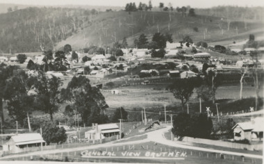
Postcard - Bruthen Victoria, H D Bulmer, 1930 c
... ...Land Settlement...Lakes Entrance Historical Society 4 Marine Parade Lakes Entrance gippsland Township Land Settlement General View Bruthen Black and white postcard of a general view of town taken from railway station, Bruthen Hotel top right background, railway crossing lower right, Bruthen Victoria Bruthen Victoria Postcard Bruthen Victoria H D Bulmer ...Black and white postcard of a general view of town taken from railway station, Bruthen Hotel top right background, railway crossing lower right, Bruthen VictoriaGeneral View Bruthentownship, land settlement -
 Lakes Entrance Historical Society
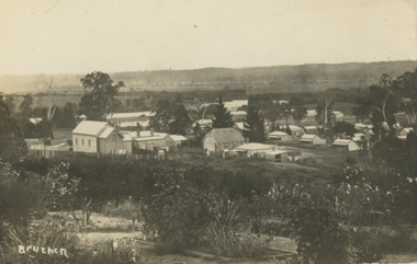
Postcard - Bruthen Victoria, 1914
... ...Land Settlement...Lakes Entrance Historical Society 4 Marine Parade Lakes Entrance gippsland Letter on back written by Bruthen rail survey camp worker dated 28/ 6 /14 Township Transport Land Settlement Bruthen 1914 Sepia toned postcard of view of Bruthen showing R C Church on left Congregational Church centre and Church of England just beyond it, Tambo River in the distance Bruthen Victoria. ...Letter on back written by Bruthen rail survey camp worker dated 28/ 6 /14Sepia toned postcard of view of Bruthen showing R C Church on left Congregational Church centre and Church of England just beyond it, Tambo River in the distance Bruthen Victoria. Also a larger black and white copy plus details of letter on the back of original cardBruthen 1914township, transport, land settlement -
 Lakes Entrance Historical Society
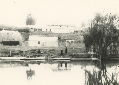
Photograph - Terraced gardens and sign for boats for let on Mitchell River near Bairnsdale Victoria, 1910 c
... ...Land Settlement...Lakes Entrance Historical Society 4 Marine Parade Lakes Entrance gippsland Sign on river bank 'Boats to Let' Houses Land Settlement Rivers Black and white photograph of substancial dwelling terraced gardens and out buildings on riverside, sign indicating boats for hire and five rowing boats on Mitchell River near Bairnsdale Victoria Photograph Terraced gardens and sign for boats for let on Mitchell River near Bairnsdale Victoria ...Sign on river bank 'Boats to Let'Black and white photograph of substancial dwelling terraced gardens and out buildings on riverside, sign indicating boats for hire and five rowing boats on Mitchell River near Bairnsdale Victoriahouses, land settlement, rivers