Showing 60 items matching "linking routes"
-
 Victorian Aboriginal Corporation for Languages
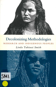
Book, Linda Tuhiwai Smith, Decolonizing methodologies : research and Indigenous peoples, 1999
From the vantage point of the colonised, the term 'research' is inextricably linked with European colonialism; the way in which scientific research has been implicated in the worst excesses of imperialism remains a powerful remembered history for many of the world's colonised peoples. Here, an indigenous researcher issues a clarion call for the decolonisation of research methods. In the first part of the book, the author critically examines the historical and philosophical base of Western research. Extending the work of Foucault, she explores the intersections of imperialism, knowledge and research; en route she provides a history of knowledge from the Enlightenment to postcoloniality. The second part of the book meets an urgent demand: people who are carrying out their own research projects need literature which validates their frustrations in dealing with various Western paradigms. In setting an agenda for planning and implementing indigenous research, the author shows how such programmes are part of the wider project of reclaiming control over indigenous ways of knowing and being.tables, diagramscolonisation, research, imperialsim -
 Whitehorse Historical Society Inc.
Map, Railway map of Victoria, 1912
Detailed map of railways in Victoria including adjacent areas of New South Wales.Detailed map of railways in Victoria including adjacent areas of New South Wales. Also shows 'principal coach routes'. On verso map of suburban lines with eastern line as far as Croydon and Bayswater. key numbers on map linked to pages of a timetable.Detailed map of railways in Victoria including adjacent areas of New South Wales.maps, railways -
 Whitehorse Historical Society Inc.
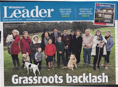
Article, North East Link Route, 2017
... North East Link Route... will be impacted by the work. North East Link Route Article Article ...Residents living near the Eastern Freeway fear that if the North East Link Authority goes ahead with Option A, which involves linking M80 to the Eastern freeway near Bulleen Road.Residents living near the Eastern Freeway fear that if the North East Link Authority goes ahead with Option A, which involves linking M80 to the Eastern freeway near Bulleen Road, large sections of Koonung Creek Reserve will be impacted by the work.Residents living near the Eastern Freeway fear that if the North East Link Authority goes ahead with Option A, which involves linking M80 to the Eastern freeway near Bulleen Road.eastern freeway, north east link authority, residents united against north east link a, koonung creek -
 Ballarat Tramway Museum
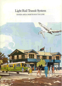
Book, Metropolitan Transit Authority (MTA), "Light Rail Transit System - Inner Area North-South Link", c1986
Sixteen page book, A4 portrait format, saddle stapled, titled "Light Rail Transit System - Inner Area North-South Link", published by the Metropolitan Transit Authority detailing the conversion of the former heavy electric suburban railway lines to St Kilda and Port Melbourne to electric trams or Light Rail. Has foreword by Tom Roper, Minister for Transport, Describes the proposed system, vehicles, development of articulated vehicles (2001, 2002), interchange with rail services, travel times and a map showing the proposed route, including a possible extension along Mitford St. and Broadway to Glenhuntly Road. Has a number of artists impressions of the vehicles at Station Pier and South Melbourne station. Includes colour photographs of the vehicles, conductors and photos of other light rail systems in Hanover and Amsterdam. Published c1986.trams, tramways, melbourne, light railways, mta, st kilda, port melbourne, articulated trams -
 Ballarat Tramway Museum
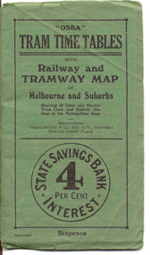
Ephemera - Timetable/s, Osboldstone & Co Pty Ltd and Printers and Publishers Melbourne, "OSBA Tram Time Tables with Railway and Tramway Map, of Melbourne and Suburbs", 1920's
Yields information about the tram timetables applicable to Melbourne's trams, including cable and electric and demonstrates the spread of Melbourne's public transport system in the early 1920's.Forty Eight page printed book contained with oversize green heavy paper covers centre stapled with a coloured map glued into the rear cover of the book titled "OSBA Tram Time Tables with Railway and Tramway Map, of Melbourne and Suburbs". Published c1920 - shows Footscray system, Victoria St Flemington link, does not show Puckle St. Timetables details Fares, first and last cars for cable and electric lines, sections and other details of the various lines. Note page 44 and 45 cannot be accessed, paper not cut correctly during the printing process - leave as is. Map prepared by Gawler and Drummond Architects, shows in colour the cable routes, electric tramways, authorised tramways and railway lines. Municipalities shown in different colours. Map folded into 12 sections. Published by Osboldstone & Co Pty Ltd, Printers and Publishers, Temple Court Place, Melbourne. Price 6d. Full scan of document added as a pdf file 5/6/2019. map, timetables, melbourne, cable trams -
 Melbourne Tram Museum
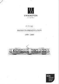
Document - Report, Swanston Trams, "Swanston Trams future projects presentation 1999 - 2000", Oct, 1999
... , deviation of route 82, Park St link, tram maintenance facilities..., deviation of route 82, Park St link, tram maintenance facilities ...Report - photocopied 27 x A4 sheets, stapled in the top left hand corner titled "Swanston Trams future projects presentation 1999 - 2000" looking for submissions from consultants to undertake a number of projects - signed by Russell Nathan, 6/10/1999. Projects included - (see image i3) - ticket machines at various locations, a city sights tram service, all night tram service, deviation of route 82, Park St link, tram maintenance facilities, consolidation of depots, tram stop improvements and traffic management initiatives.trams, tramways, swanston trams, national express, proposals, route 82 -
 Eltham District Historical Society Inc
Photograph - Digital Photograph, Alan King, Maroondah Aqueduct Siphon Bridge over the Plenty River, 26 January 2008
Opened in 1891, the bridge formed part of the Maroondah Aqueduct carrying water from Watts River near Healesville to the reservoir at Preston where it joined Melbourne's metropolitan water system. Covered under Heritage Overlay, Nillumbik Planning Scheme. Published: Nillumbik Now and Then / Marguerite Marshall 2008; photographs Alan King with Marguerite Marshall.; p99 Built to supply thirsty Melbourne in the late 19th century, the siphon bridge spanning the Plenty River off Leischa Court, Greensborough, was part of an engineering masterpiece. Opened in 1891, the bridge formed part of the Maroondah Aqueduct carrying water from the Watts River near Healesville to the reservoir at Preston where it joined the metropolitan distribution system. A major link in Melbourne’s water supply, it also had a huge impact on communities, which mushroomed along its route. Named after the Aboriginal word for the area around the Maroondah Reservoir, the Maroondah Aqueduct was fully operational until the 1970s. Since the 1980s the land along parts of the aqueduct have been used for walking and bicycle riding, shaded in places by Monterey Pine trees planted to stabilise the surrounding ground. From 1857 the Yan Yean Reservoir supplied Melbourne’s water but the growing city needed additional catchments.1 In 1886 work began on a weir on the Watts River to enable the aqueduct to carry most of the river water 41 miles (66km) to Melbourne. The aqueduct, built by the Board of Works, is the oldest remaining aqueduct near Melbourne and was probably the first built with concrete.2 Although the aqueduct is now only used between the Maroondah and Sugarloaf Reservoirs, it can still be traced across the Shire. It extends from the Maroondah Reservoir through Christmas Hills, Kangaroo Ground, Research, Eltham, St Helena and then previously wound west through Greensborough to Reservoir.3 Built by horse and manpower the aqueduct gravity fed 25 million gallons (113.6ML) of water a day to Melbourne along a gradient of one foot to the mile. It included 25 miles (41km) of open concrete and brick channel, six miles (10km) of tunnels, and nine miles (15km) of 14 inverted siphons of riveted wrought-iron across creeks. Bricks for the aqueduct were made from clay found near the sites and remains of several kilns can still be found between Kangaroo Ground and Christmas Hills. Building the aqueduct transformed local communities. An abattoir was established at Christmas Hills. Grog shanties and labourers’ camps sprang up and local courts dealt with cases of ‘petty pilfering and boisterous behaviour’.4 The Kangaroo Ground school population jumped to 91, crammed into a room with one teacher. Miners who built the tunnels camped just north of Churinga in Greensborough – then called Tunnel Hill Camp – and adjacent to the Evelyn Arms Hotel. The miners’ high spirits were sometimes quenched in horse troughs or by a ‘welt under the ear and kick on the behind’ as the local constable calmed them down rather than lock them up.5 But the growing city of Melbourne needed more water, so the O’Shannassy catchment, east of Warburton, was added to the system in 1914. In 1920 work began on the present concrete Maroondah Dam one mile (1.6km) from the weir on the Watts River. The aqueduct capacity was thus doubled to 50 million gallons (227ML) a day.6 Intense land development threatened to pollute the open water supply, so channel sections were replaced with large pipes. In the late 1960s a large water main was built from the tunnel outlet at Research and extended through St Helena and Greensborough, so this section of the aqueduct was taken out of use. Long sections of the unused open channels in Greensborough and Bundoora were destroyed, but the old channel in Research and Eltham North remained largely intact. In the 1970s, the Sugarloaf Reservoir was constructed, inundating 445 hectares of land in Christmas Hills. Sugarloaf was officially opened in 1980 and serves as a water storage and treatment plant supplying Melbourne. In the early 1980s pipes replaced the section from Sugarloaf Reservoir to the tunnel entrance at Kangaroo Ground. The Research-Kangaroo Ground tunnel operates as part of the pipeline system.This collection of almost 130 photos about places and people within the Shire of Nillumbik, an urban and rural municipality in Melbourne's north, contributes to an understanding of the history of the Shire. Published in 2008 immediately prior to the Black Saturday bushfires of February 7, 2009, it documents sites that were impacted, and in some cases destroyed by the fires. It includes photographs taken especially for the publication, creating a unique time capsule representing the Shire in the early 21st century. It remains the most recent comprehenesive publication devoted to the Shire's history connecting local residents to the past. nillumbik now and then (marshall-king) collection, maroondah aqueduct, pipe bridge, siphon bridge -
 Melbourne Tram Museum
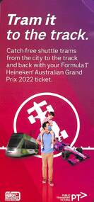
Pamphlet - Hanging strip type notice, Public Transport Victoria (PTV), Tram it to the track, 2022
Provides tram information for Australian Formula 1 Grand Prix 2022. Contains a link for further information.hanging strip type notice & pamphlet trams, special event services, tramways, route 12, route 96, grand prix -
 Melbourne Tram Museum
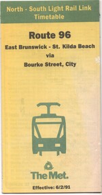
Document - Timetable - Route 96 - East Brunswick - St Kilda Beach, The Met, 2/1991
Timetable dated 6-2-1991 provides information on the East Brunswick to St Kilda Beach via Bourke Street services, including a map, route description, time points, fare secrtions and contact details. Published by The Met. Has the words "North-South Light Rail Link" on the top of the document. Yields information about Route 96 tram services on the St Kilda light rail line.Document - 10 fold sheet - Timetable - Route 96 - East Brunswick - St Kilda Beachtramways, timetable, route 96, east brunswick, st kilda beach, light rail, the met -
 Melbourne Tram Museum
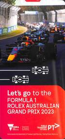
Pamphlet - Hanging strip type notice, Public Transport Victoria (PTV), Let's go to the Formula 1 Rolex Australian Grand Prix 2023, 2023
Provides tram information for Australian Formula 1 Grand Prix 2023. Contains a link for further information.hanging strip type notice & pamphlet trams, special event services, tramways, route 12, route 96, grand prix -
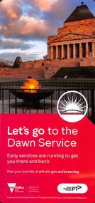 Melbourne Tram Museum
Pamphlet - Hanging strip type notice, Public Transport Victoria (PTV), Let's go to the Dawn Service / Tram timetable changes in April 2023, 2023
Provides tram information for ANZAC Day Dawn Service 2023. Contains a link for further information. Reverse side has information about new timetables for specific routes. Yields information about tram service and timetable changes.hanging strip type notice for Dawn Service and timetable changestrams, special event services, tramways, anzac day -
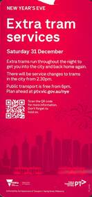 Melbourne Tram Museum
Pamphlet - Hanging strip type notice, Public Transport Victoria (PTV), New Years Eve - Extra tram services, 2023
Provides tram information for New Years Eve 2022. Contains a link for further information. Reverse side has information about new timetables for specific routes. Yields information about tram service and timetable changes.hanging strip type notice for New Years Eve Service and timetable changestrams, special event services, tramways, new years eve -
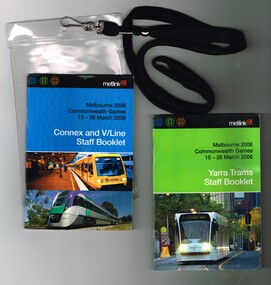 Melbourne Tram Museum
Ephemera - Timetable, Metlink, "Melbourne 2006 Commonwealth Games - 16-26 March 2006" - Yarra Trams Staff Booklet", Mar. 2006
Set of two books printed in full colour on gloss white paper, centre stapled providing information for transport staff involved in the Commonwealth Games held in Melbourne 16-26 March 2006. Both have details of event for train, tram and bus crews, event program and transport map, including shunting details, announcements, bus replacement services, electric or automatic points, route alterations and security information. On the back cover has contact telephone numbers and web addresses. Both have the Met Link logos on the front covers. Items contained with in a plastic envelope with a black neck band. .1 - "Melbourne 2006 Commonwealth Games - 16-26 March 2006" - Yarra Trams Staff Booklet" - 80 pages with a photo of 5014 on front cover. 2nd copy added 11-12-17 from Donation of Ron Scholten. .2 - "Melbourne 2006 Commonwealth Games - 16-26 March 2006" - Connex and V/Line Staff Booklet" - 96 pages with a Alstom suburban train and Bombardier Velocity set on the front covers. 2 copies held.trams, tramways, commonwealth games, connex, v/line, yarra trams, metlink -
 Melbourne Tram Museum
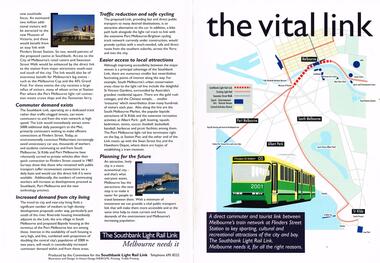
Pamphlet, Committee for the Southbank Light Rail Line, "the vital link", 1993?
Pamphlet - full colour A3 sheet folded to A4, titled "the vital link", outlining a proposal for a tram line connecting Flinders St station to Clarendon St, Port Junction, via the former railway bridge, connecting Batman Ave tram line. Published by the Committee for the Southbank Light Rail Line. Gives reasons and benefits for such a link. Published based on a printing date 1993. Features an image of 2001 on front cover and crossing the Yarra River.trams, tramways, flinders st station, clarendon st, new tramway, batman ave, route 96, light rail, yarra river, tram 2001 -
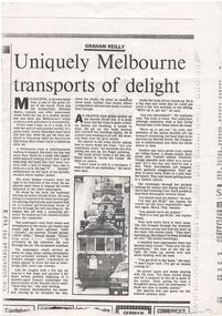 Melbourne Tram Museum
Newspaper, Graham Reilly, "Uniquely Melbourne Transports of Delight", mid 1980's?
Newspaper photocopy of an article, undated, titled "Uniquely Melbourne Transports of Delight", written by Graham Reilly about Melbourne tans and travelling on them and some of the passengers that travel, fares, Bourke St. Author's Linked in website accessed 13/8/2018, shows a career with Fairfax Newspapers - The Age. Written mid 1980's? Has a photo of W2 431 leading a procession of trams - route 48 and route 75.trams, tramways, melbourne, trams, passengers, bourke st, tram 431 -
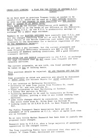 Melbourne Tram Museum
Pamphlet, P. Thomas, South Melbourne Depot, "Cross City Linking - A plan for the future or another PTC Fiasco????", c1992
Pamphlet, letter or notice - photocopy onto an A4 sheet, both sides, titled "Cross City Linking - A plan for the future or another PTC Fiasco????", looking at the proposed project , relationships with the Public Transport Users Association (PTUA), route changes, union actions, impacts of proposals and asking members to be involved in the proposal at South Melbourne Depot - c1992 See Reg Item 1535 for a report on this project.trams, tramways, the met, unions, south melbourne depot, management, ptc, routes, w class, operations, buses, ptua -
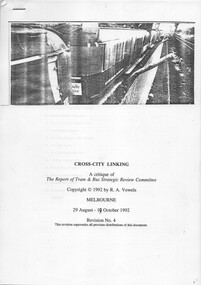 Melbourne Tram Museum
Document - Report, R. A. Vowels, "Cross-City Linking - A critique of the Report of Tram and Bus Strategic Review Committee", Oct. 1992
... Trams tramways PTC Routes W Class Operations Buses PTUA Report ...Report - 25 A4 pages photocopied stapled in the top left hand corner, titled "Cross-City Linking - A critique of the Report of Tram and Bus Strategic Review Committee". Prepared by R. A. Vowels in Oct. 1992, is heavily critical of the report and with serious concerns and identified a number of deficiencies. Has a table of contents. Considers the W class trams and other trams. Provides suggestions regarding alternative routing of trams. Includes some copies of newspaper clippings. Not know who commissioned the report - may have been the Union or the Public Transport Users Association. See also Reg Item 2232 for South Melbourne Depot views, See also Reg Item 2652 for a short item about the route proposals.trams, tramways, ptc, routes, w class, operations, buses, ptua -
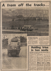 Melbourne Tram Museum
Newspaper, The Sun, “A tram off the tracks”, 22/10/1977 12:00:00 AM
“A tram off the tracks” The Sun, Saturday, Oct 22, 1977 Photos and text Tram # 86 Photos of tram # 86 being transported on semi-trailer on Hume Highway at Beveridge on its way to Orange, NSW. Part of display by Bathurst-Orange Development Corporation, planning to build a new town between the two cities. Trams among the different types of transport being considered to link the proposed town to its neighbours. Tram displays “Brunswick-Moreland Rd” and route number 954.trams, tramways, displays, trucks, z class, transporting trams, tram 86 -
Melbourne Tram Museum
Newspaper, The Age, “Fears Caulfield to Rowville tram plan no longer on track”, 30/05/2019 12:00:00 AM
Newspaper clippings titled: “Fears Caulfield to Rowville tram plan no longer on track” Newspaper clipping from the Age 30/5/2019 by Timna Jacks Councils in Melbourne's south-east suburbs concerned that plans for new tram line linking Caulfield train station and Monash University's Clayton campus have been shelved due to no money allocated in the budget. Premier Daniel Andrews had promised the government would plan and design an 18 kilometre tram route from Caulfield to Rowville.trams, tramways, planning, caulfield, tram routes, new tramway -
 Melbourne Tram Museum
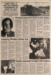
Newspaper, The Emerald Hill, Sandridge and St Kilda Times, "Light Rail: A matter where agreement is hard to get", 23/04/1987 12:00:00 AM
Newspaper cutting from The Emerald Hill, Sandridge and St Kilda Times - 23/4/1987 titled "Light Rail: A matter where agreement is hard to get" about the conversion of the St Kilda and Port Melbourne rail lines to Light Rail. Has three sub-articles, quote the General Manager of The Met Mr. Ed Dotson, Mr Patrick O'Connor Public Transport Users Association about the keeping of the Flinders St link and Mr Noel Willis, the President of the Bayside Public Transport Association who was opposed. Has photos of each of the people involved and a B class tram on route 75 in the Burwood Highway.trams, tramways, light rail, st kilda, port melbourne, conversion, east burwood, route 75 -
 Melbourne Tram Museum
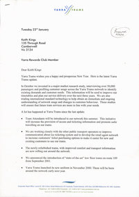
Letter, Keith Kings, "Yarra Rewards Club Member", "Yarra Trams Update", "Yarra Connections", 2001 to 2004
Set of 13 letters, from or to Yarra Trams during 2001 and 2002 to Keith Kings re various maters, sending the latest issue of "Yarra Trams Update" or "Yarra Connections" 1 - 23/1/2001 - latest news and the proposed launch of "Yarra Rewards Club Member" 2 - 25/5/2001 3 - 13/8/2001 - now known as "Yarra Connections" 4 - letter to Paul Matthews, Marketing Manager, dated 14/10/2001 re various matters, including road markings, timetables at tram stops and the newsletters. 5 - 11/12/2001- Superstops 6 - 2/1/2002 7 - 1/5/2002 8 - 21/11/2002 - Yarra Connections No. 9, notes possible take over of M>Tram 9 - 23/4/2003 10 - Feedback from Keith about route 70 trams, dated 10/5/03 11 - 4/5/2003 - map attached to above about service improvements in the CBD. 12 - 5/8/2003 - Opening to Box Hill and Met Link. 13 - 2004 - not dated, first issue of Yarra Connections for 2004 - merger with M>Tram and a copy of Reg Item 5033. All signed by Paul Matthews as Marketing Manager.trams, tramways, yarra trams, passengers, m>tram, box hill, letters, metlink -
 Narre Warren and District Family History Group
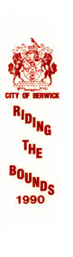
Textile, City of Berwick, Rosette/Ribbon Riding the Bounds City of Berwick 1990
The Riding of the Bounds was an annual event that took place in Berwick. It linked back to a centuries-old tradition in sister city Berwick upon Tweed, England. Riders followed a route through local streets and participate in ceremonies along the city's border. The Mayor would wave off riders from the local showgrounds with instructions to inspect the boundary with the neighbouring municipality. Once the ride was complete, the Marshall would report back to the Mayor that the boundaries were secure, and this would herald the commencement of the presentation ceremony. This re-enactment of the Berwick-Upon-Tweed Riding of the Bounds was filled with pomp and ceremony and many of the riders took the opportunity to dress in period costume in recognition of the history of this event. This information is from https://collection.casey.vic.gov.au/Ribbon for City of Berwick Riding the Bounds 199. Printed on white material with red ink. Has the City of Berwick coat of arms at the top of the ribbon.city of berwick, riding the bounds, city of berwick coat of arms, horses, berwick boundaries -
 Narre Warren and District Family History Group
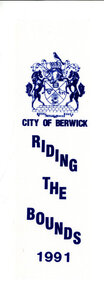
Textile, City of Berwick, Rosette/Ribbon Riding the Bounds City of Berwick 1991
The Riding of the Bounds was an annual event that took place in Berwick. It linked back to a centuries-old tradition in sister city Berwick upon Tweed, England. Riders followed a route through local streets and participate in ceremonies along the city's border. The Mayor would wave off riders from the local showgrounds with instructions to inspect the boundary with the neighbouring municipality. Once the ride was complete, the Marshall would report back to the Mayor that the boundaries were secure, and this would herald the commencement of the presentation ceremony. This re-enactment of the Berwick-Upon-Tweed Riding of the Bounds was filled with pomp and ceremony and many of the riders took the opportunity to dress in period costume in recognition of the history of this event. This information is from https://collection.casey.vic.gov.au/Ribbon for City of Berwick Riding the Bounds 19919. Printed on white material with blue ink. Has the City of Berwick coat of arms at the top of the ribbon.city of berwick, riding the bounds, city of berwick coat of arms, horses, berwick boundaries -
 Narre Warren and District Family History Group
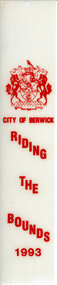
Textile, City of Berwick, Rosette/Ribbon Riding the Bounds City of Berwick 1993
The Riding of the Bounds was an annual event that took place in Berwick. It linked back to a centuries-old tradition in sister city Berwick upon Tweed, England. Riders followed a route through local streets and participate in ceremonies along the city's border. The Mayor would wave off riders from the local showgrounds with instructions to inspect the boundary with the neighbouring municipality. Once the ride was complete, the Marshall would report back to the Mayor that the boundaries were secure, and this would herald the commencement of the presentation ceremony. This re-enactment of the Berwick-Upon-Tweed Riding of the Bounds was filled with pomp and ceremony and many of the riders took the opportunity to dress in period costume in recognition of the history of this event. This information is from https://collection.casey.vic.gov.au/Ribbon for City of Berwick Riding the Bounds 1993. Printed on white material with red ink. Has the City of Berwick coat of arms at the top of the ribbon.city of berwick, riding the bounds, city of berwick coat of arms, horses, berwick boundaries -
 Narre Warren and District Family History Group
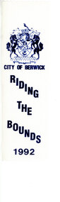
Textile, City of Berwick, Rosette/Ribbon Riding the Bounds City of Berwick 1992
The Riding of the Bounds was an annual event that took place in Berwick. It linked back to a centuries-old tradition in sister city Berwick upon Tweed, England. Riders followed a route through local streets and participate in ceremonies along the city's border. The Mayor would wave off riders from the local showgrounds with instructions to inspect the boundary with the neighbouring municipality. Once the ride was complete, the Marshall would report back to the Mayor that the boundaries were secure, and this would herald the commencement of the presentation ceremony. This re-enactment of the Berwick-Upon-Tweed Riding of the Bounds was filled with pomp and ceremony and many of the riders took the opportunity to dress in period costume in recognition of the history of this event. This information is from https://collection.casey.vic.gov.au/Ribbon for City of Berwick Riding the Bounds 1992. Printed on white material with blue ink. Has the City of Berwick coat of arms at the top of the ribbon.city of berwick, riding the bounds, city of berwick coat of arms, horses, berwick boundaries -
 Narre Warren and District Family History Group
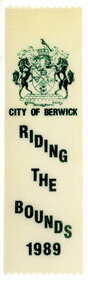
Textile, City of Berwick, Rosette/Ribbon Riding the Bounds City of Berwick 1989
The Riding of the Bounds was an annual event that took place in Berwick. It linked back to a centuries-old tradition in sister city Berwick upon Tweed, England. Riders followed a route through local streets and participate in ceremonies along the city's border. The Mayor would wave off riders from the local showgrounds with instructions to inspect the boundary with the neighbouring municipality. Once the ride was complete, the Marshall would report back to the Mayor that the boundaries were secure, and this would herald the commencement of the presentation ceremony. This re-enactment of the Berwick-Upon-Tweed Riding of the Bounds was filled with pomp and ceremony and many of the riders took the opportunity to dress in period costume in recognition of the history of this event. This information is from https://collection.casey.vic.gov.au/ Ribbon for City of Berwick Riding the Bounds 1989. Printed on white material with green ink. Has the City of Berwick coat of arms at the top of the ribbon. city of berwick, riding the bounds, city of berwick coat of arms, horses, berwick boundaries -
 Melbourne Tram Museum
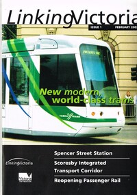
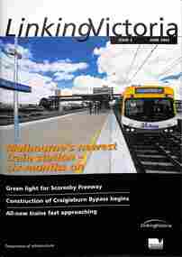
Book, Department of Infrastructure (DOI), "Linking Victoria - issue 1", Feb. 2002
Book published by the Victorian Department of Infrastructure. Includes a message from Steve Bracks Premier and Peter Batchelor Minister for Transport. Looks at Transport Planning, Spencer St Station redevelopment, Fast rail regional links, passenger services, new low floor trams, notes Yarra and M>Tram rollingstock, route 109 to Box Hill, buses and other transport projects underway or planned. See item 8697 for issue 2.Yields information about DOI projects that were being undertaken during 2002.Book - 20 A4 pages, centre stapled printed on gloss paper titled "Linking Victoria - issue 1 February 2002"trams, tramways, planning, doi, m>tram, spencer st, public transport, railways -
 Melbourne Tram Museum
Functional object - Tramcar component, C. Brose Wuppertal Germany, Set of destination indicator equipment that was fitted to Z3 and A class trams, c1985
Set of destination indicator equipment that was fitted to Z3 and A class trams. Each item consists of various electronic parts contained within a metal case that could have been cabled together. Equipment manufactured by (Carl) C. Brose of Wuppertal Germany and maintained by Font Electronics of Melbourne - some items have the manufacturers details on them along with the details of the maintenance company and serial numbers etc. Photo .1 - shows the set of equipment as placed on display in the training room. .1 - set of two route number boxes, three individual controlled blinds, driven by a motor and control gear. Has a Fluro light fitted internally. See images .2 to .5 .2 - Small side destination indicator, with driven blind, electronic equipment with motor on the underside of the box - for use in Z class trams - see images .6 to .9 .3 - as for .2, but with motor mounted right side, used in A class trams, see images .10 to .12 .4 - set of two control panels with selection equipment for selecting the destination (by number) and route number with indicators and start button - see image .13 to 14 .5 - set of two long main rolls indicators, with control gear and Fluro light internally, driven by an internal electric motor - see images 17 and 18 .6 - set of two linking mechanism for the various boxes with large cables cut off for each of the four tram boxes. Would have been control panel item .4 - see image 15 and 16. See e-mail from Simon dated 17/11/2014. See reg Item 4617 for a small side destination roll.trams, tramways, destination indicators, a class, z3 class, transport equipment -
 Melbourne Tram Museum
Book, Department of Infrastructure (DOI), "Linking Victoria issue 2", June 2002
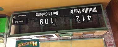
Book titled "Linking Victoria issue 2 June 2002" published by the Department of Infrastructure on the current transport projects being undertaken. Includes a message from the Minister for Transport Peter Batchelor, Comeng upgrades, new X'Trapolis trains, tram superstops, Box Hill extension, Route 109, Victoria Gardens and ST Vincent Plaza works, and many road projects including the Leongatha tourist rail projects. See item 2339 for issue 1.Yields information about DOI projects that were being undertaken during 2002.Book - 20 A4 pages, centre stapled, full colour.trams, tramways, planning, doi, route 109, st vincents plaza, public transport -
 Melbourne Tram Museum
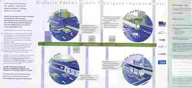
Pamphlet, VicRoads, "Victoria Parade Public Transport improvements", August 2002
Pamphlet titled "Victoria Parade Public Transport improvements", dated August 2002 about changes to traffic signals, intersections, tram stop relocations, transit and bus lane, as part of the Route 109 project. Has a feedback form. Has the VicRoads, Linking Victoria, Yarra Trams and National bus logos.Yields information about the planning for the introduction of route 109 and traffic planning for Victoria Parade.Document - 5 fold A5 printed on gloss paper.yarra trams, route 109, tramways, buses, victoria parade, vicroads