Showing 40 items matching "little eltham north"
-
 Eltham District Historical Society Inc
Photograph, Birch Cottage, Eltham-Yarra Glen Road, c.1970, 1970
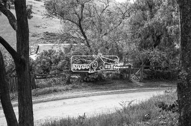
GC advised that when they first arrived in Eltham in the late 1960s, he would enjoy driving out to Yarra Glen. The Eltham-Yarra Glen road was unmade at the time. He passed this residence on the north side of the road. It was totally remote. GC found the juxtaposition of this little cottage with its surburban wire gate out in the remoteness of the landscape intriguing. Since then the road has been reconstructed and diverted away from the cottage which is now owned by Parks Victoria.Digital TIFF file Scan of 35mm Ilford HP4 black and white transparencyIlford HP4birch cottage, christmas hills, early settlers, edwin samuel birch, eltham-yarra glen road, honor mary birch, honor mary williams, john hill, watsons creek -
 Eltham District Historical Society Inc
Photograph, Birch Cottage, Eltham-Yarra Glen Road, c.1970, 1970
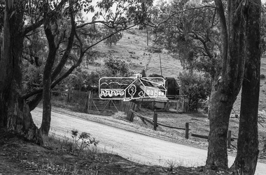
GC advised that when they first arrived in Eltham in the late 1960s, he would enjoy driving out to Yarra Glen. The Eltham-Yarra Glen road was unmade at the time. He passed this residence on the north side of the road. It was totally remote. GC found the juxtaposition of this little cottage with its surburban wire gate out in the remoteness of the landscape intriguing. Since then the road has been reconstructed and diverted away from the cottage which is now owned by Parks Victoria.Digital TIFF file Scan of 35mm Ilford HP4 black and white transparencyIlford HP4birch cottage, christmas hills, early settlers, edwin samuel birch, eltham-yarra glen road, honor mary birch, honor mary williams, john hill, watsons creek -
 Eltham District Historical Society Inc
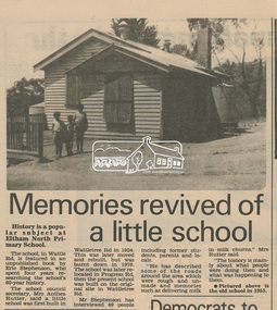
Newsclipping, Memories revived of a little school; publication unk, 1992c
Eltham North Primary SchoolDigital file only - Digitised by EDHS from a scrapbook on loan from Beryl Bradbury (nee Stokes), daughter of Frank Stokes.anthea rutter, beryl bradbury (nee stokes) collection, eltham north primary school, eric stephenson, wattle road, wattletree road -
 Eltham District Historical Society Inc
Postcard - Photograph, Eltham from Greensborough Road, No. 1, c.1910
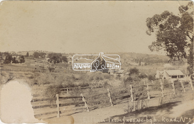
The view is looking southeast from near Eltham Road (present-day Sherbourne Road) across Bolton and Bridge streets towards the village of Little Eltham running down the main road (Maria Street) . On the immediate right is Mrs Mary Jane Smart's family home located on the north side of Bridge Street at the intersection with Bolton Street, facing Bolton Street (now part of present day Brisbane Street and occupied by the Kitchen Design Centre). An original early settler's cottage, it was built by Mary Jane Smart's parents, Edwin Bailey and Jane (nee Matthews). Mary Jane Smart was born in the cottage. She married an Englishman, Alexander Wilson Smart who disappeared to Western Australia in the early 1900s in search of gold. He ultimately married again in W.A., committing bigamy and then committed murder and was hung in 1911. Visible at the top left are Watson's (two-storey) Eltham Hotel at the corner of Pitt Street and Maria Street and the Evelyn Hotel directly opposite.Sepia postcardNotations in biro 'A. Petrie', rest in pencil as follows St Margarets N end Shows Wesleyan Church Small Bank Double Storey on Hotel's south end Pearsons house Note roof structure Surface damage to lower left corner1910, bridge street, cba bank, church, clark bros. photo, early settlers, eltham, eltham hotel, evelyn hotel, fountain of friendship hotel, greensborough, mary jane smart (nee bailey), pearson house, pre 1900, road no 1, smart family home, smart home, st margarets, watsons hotel, wesleyan church -
 Eltham District Historical Society Inc
Photograph, Main Road, Research
... north towards the Little Eltham Theatre 3.... the Little Eltham Theatre 3. Main Road, Research Photograph ...Three colour photographs showing Main Road, Research in the vicinity of Research Industrial Estate. 1. Looking north towards the Aqueduct 2. Looking north towards former road alignment 3. Looking north towards the Little Eltham Theatre 3.main road, research, research industrial estate -
 Eltham District Historical Society Inc
Photograph, Birch Cottage, Eltham-Yarra Glen Road, c.1970, 1970
GC advised that when they first arrived in Eltham in the late 1960s, he would enjoy driving out to Yarra Glen. The Eltham-Yarra Glen road was unmade at the time. He passed this residence on the north side of the road. It was totally remote. GC found the juxtaposition of this little cottage with its surburban wire gate out in the remoteness of the landscape intriguing. Since then the road has been reconstructed and diverted away from the cottage which is now owned by Parks Victoria.Digital TIFF file Scan of 35mm Ilford HP4 black and white transparencyIlford HP4birch cottage, christmas hills, early settlers, edwin samuel birch, eltham-yarra glen road, honor mary birch, honor mary williams, john hill, watsons creek -
 Eltham District Historical Society Inc
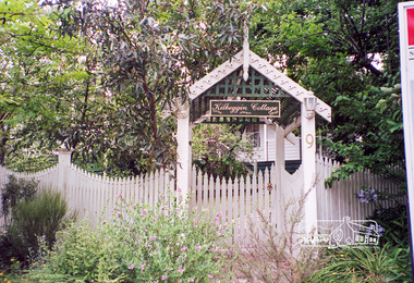
Photograph, Margaret Ball, 9 John Street, Eltham, 1999
"Kilbeggin Cottage" front gate, picket fence and garden obscures the weatherboard house over two blocks at 7 - 9 John Street, Eltham. Possibly a "For Sale" sign is at the side of the photograph for 11 John Street next door. Built about 1878 for carpenter Richard Bettison, John Street is part of the original Holloway subdivison in the area known as Little Eltham. The Margaret Ball (Pre 1960s Houses) Collection was a personal project initiated to mark the year 2000 and arose as a result of the disappearance of many pre-1960s parts of Eltham due to development. Approximately 200 pre-1960s style houses that were left in Eltham between Main Road and east to Bible Street, between Cecil Street to the north and south to Dalton Street were photographed in late 1999. Not all of the houses could be photographed; some because the garden or trees blocked the view of the house, others because of rubbish or cars were in the way, some because people were working on the house or in the gardens at the time.Roll of 35mm colour negative film, 7 stripsKodak GC 400-6eltham, houses, streets, margaret ball (pre 1960s houses) collection, john street -
 Eltham District Historical Society Inc
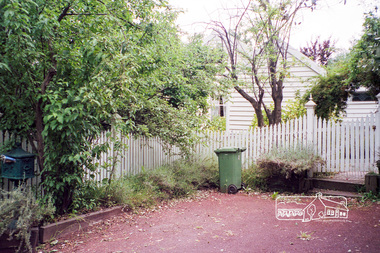
Photograph, Margaret Ball, 9 John Street, Eltham, 1999
"Kilbeggin Cottage",a weatherboard house over two blocks at 7 - 9 John Street, Eltham. Built about 1878 for carpenter Richard Bettison, John Street is part of the original Holloway subdivison in the area known as Little Eltham.The Margaret Ball (Pre 1960s Houses) Collection was a personal project initiated to mark the year 2000 and arose as a result of the disappearance of many pre-1960s parts of Eltham due to development. Approximately 200 pre-1960s style houses that were left in Eltham between Main Road and east to Bible Street, between Cecil Street to the north and south to Dalton Street were photographed in late 1999. Not all of the houses could be photographed; some because the garden or trees blocked the view of the house, others because of rubbish or cars were in the way, some because people were working on the house or in the gardens at the time.Roll of 35mm colour negative film, 7 stripsKodak GC 400-6eltham, houses, streets, margaret ball (pre 1960s houses) collection, john street -
 Eltham District Historical Society Inc
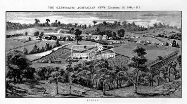
Photograph, Samuel Calvert, Eltham, The Illustrated Australian News, December 26, 1884, p212, 1884
A description in the newspaper near the illustration (page 210) reads as follows: "Eltham is a pretty little township on the Yarra Flats road, about 14 miles east north east of Melbourne, from which place there is communication by way of Heidelberg. It has a population of nearly 400 inhabitants, but in addition it is the centre of a large district extending over about 203 square miles, having a population of 2344. The land in the district is mostly used for grazing purposes, although as a rule the small farms grow a good deal of wheat, oats and other agricultural produce. A large quantity of fruit, especially raspberries and strawberries, is also produced, the rich alluvial flats along the creek upon which the township is situated being very well adapted for that purpose. Gold has also been found in the vicinity of the township, but not in remunerative quantities". This photo forms part of a collection of photographs gathered by the Shire of Eltham for their centenary project book,"Pioneers and Painters: 100 years of the Shire of Eltham" by Alan Marshall (1971). The collection of over 500 images is held in partnership between Eltham District Historical Society and Yarra Plenty Regional Library (Eltham Library) and is now formally known as 'The Shire of Eltham Pioneers Photograph Collection.' It is significant in being the first community sourced collection representing the places and people of the Shire's first one hundred years.Digital imageshire of eltham pioneers photograph collection, eltham, illustrated australian news -
 Eltham District Historical Society Inc
Photograph - Digital Photograph, Alan King, Alistair Knox Park, Eltham, 2008
Alistair Knox Park, an oasis of peace and beauty. Covered under National Trust of Australia (Victoria) Landscape Significance and Heritage Overlay, Nillumbik Planning Scheme. Published: Nillumbik Now and Then / Marguerite Marshall 2008; photographs Alan King with Marguerite Marshall.; p173 It is hard to imagine that the Alistair Knox Park, an oasis of peace and beauty beside busy Main Road, Eltham, was once the township’s rubbish dump. It was only in the 1970s that the tip was transformed into this beautiful six hectare space, which later earned it a National Trust Landscape classification. Before its life as a dump, the area was used for small farms. Thanks largely to the foresight and efforts of local environmental builder Alistair Knox, the park was designed sympathetically with the character of the wider Eltham landscape. Then, appropriately, the park was named after Knox, who was an Eltham Shire Councillor from 1971 to 1975 and Shire President in 1975. The park designers were four major forces in the urban bush landscape garden –Knox, landscape designer Gordon Ford, artist Peter Glass and landscaper Ivan Stranger. The National Trust citation for the park, originally called Eltham Town Park, includes the Eltham railway trestle bridge and the Shillinglaw Cottage. The citation states ‘the semi-natural setting of the parkland provides a landscape which is evocative of the history of the area’. Manna Gums (Eucalyptus viminalis) and Candlebarks (Eucalyptus rubida) are significant features. Most of the park’s construction was directed by Bob Grant, Superintendent of the Parks and Gardens Department for the Eltham Shire Council. First plantings occurred in Arbour Week in 1973, then the lake and botanic area were completed in 1975, with Federal Government funding, and the toilet block in 1978. Bounded by the Eltham railway line, Panther Place, Main Road, Bridge and Susan Streets, the park is in a valley about a kilometre wide overlooked by steep hills at the east and west. The Diamond Creek flows through it and the picturesque historic timber trestle railway bridge edges the north. Informal plantings of Australian indigenous and native species in open and undulating grassed settings blend with the natural landscape of the Diamond Creek to the west. The bush-style plants, particularly around the creek, balance with open lawns, paths and a cascade flowing from a small lake to another below. A footbridge over the creek leads to the park’s west. The park includes an adventure playground and barbecue areas. The park stands on part of the land bought from the Crown in 1851 by Josiah Holloway, who subdivided it into allotments and which he called Little Eltham. Most of the land was subdivided into residential lots, but the creek valley, on which the park stands, was subdivided into farm-size lots, used mainly for orchards and grazing. One of the earliest owners was John Hicks Petty, who in 1874 bought a plot from Holloway. Other families who owned properties in that area, included Rees, Clark, Waterfall, Graham, Hill and Morant. In 1901 the railway was built through the area. Jock Read, an Eltham resident since around 1920, remembers several farms in the 1920s and ’30s that occupied the site of today’s park. A poultry farm, which extended from present day Panther Place, was owned by the Gahan family. Next to that farm was another for grazing cattle owned by Jack Carrucan. Beside this was land owned by John Lyon. A doctor lived beside this, and at the north-west corner of Bridge Street and Main Road stood a memorial to the soldiers who died in World War One, which was later moved to the RSL site. Mr Read also remembers other farms and orchards west of the creek In the early 1960s the Eltham Council began buying these farms and in the late 1960s turned the areas east of the Diamond Creek into a garbage tip. When this was filled above the creek’s flood plain, the tip was moved to the west of the creek.This collection of almost 130 photos about places and people within the Shire of Nillumbik, an urban and rural municipality in Melbourne's north, contributes to an understanding of the history of the Shire. Published in 2008 immediately prior to the Black Saturday bushfires of February 7, 2009, it documents sites that were impacted, and in some cases destroyed by the fires. It includes photographs taken especially for the publication, creating a unique time capsule representing the Shire in the early 21st century. It remains the most recent comprehenesive publication devoted to the Shire's history connecting local residents to the past. nillumbik now and then (marshall-king) collection, alistair knox park, eltham