Showing 1585 items
matching lundy-clarke
-
 Eltham District Historical Society Inc
Folder, Leslie Edward Clarke and Thomas Clarke
Folder of information on Leslie Edward Clarke and Thomas Clarke, councillors.leslie edward clarke, thomas clarke -
 Melton City Libraries
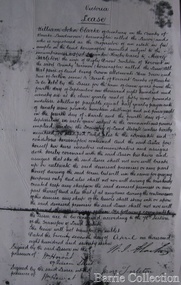
Document, William John Clarke Lease, Unknown
Mr John Purchase came from Heidelberg, and was dairying on the east side of Melton, on the Footscray road, in the Braybrook Shire. His daughter married Mr Ralph Parkinson, J.P., Mr Purchase sold his farm to the late Sir William Clarke, and then went home to England with his wife; his son, John, stopped in Victoria.Copy of a William John Clarke's purchase of landlocal identities -
 Mt Dandenong & District Historical Society Inc.
Photograph, View from George Barber's Home To His Stables
John Lundy-Clarke grew up in the Kalorama/Mt Dandenong area and later in life (1972-74) began to write a comprehensive history of the area working from an original settlement map in an effort to cover all areas. This photograph was taken by John Lundy-Clarke in 1973 to show changes to the environment sine 1905.Black and white photograph with tangled bush and small shed in foreground looking towards a cleared area. Handwritten description on reverse written by John Lundy-ClarkeView from Barbers drive to his stables close to where 1905 picture was taken. Stables in foreground. Looking towards Gap. Taken JLC November 1973.barbers road, john lundy-clarke, kalorama -
 Vision Australia
Equipment - Object, Specto Ltd, Clarke and Smith talking book machine with tapete
In 1965 the Clarke & Smith Talking Book Cassette Cartridge made it's debut at the Olympia Show. Popularly known as a 'tapete', it weighed considerably less than the earlier book cassette cartridges and allowed for up to 6 tracks (13 hours recording time) to be played.Clarke and Smith talking book cassette cartridge player consisting of plastic rectangular case with buttons for navigational controls, light green front and top of machine and darker green on sides, power cord and 5 buttons. Also includes tapete "Words for murder perhaps" by Edward Candy and ready by Stanley Pritchard.Clarke & Smith Track change Play -- Off Volume Phones This equipment remains the property of the Braille & Talking Book Library, 31-51 Commercial Road, South Yarra, 3141. Phone: (03) 267 6022 Dyna Tape labels: J21075 Play Rewindaudio equipment, clarke and smith -
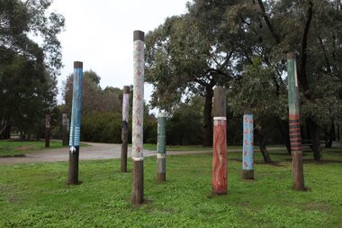 City of Ballarat
Artwork, other - Public Artwork, Koori Totem Poles by Tom Clarke, 2003
Ten unique hand painted poles (wooden telegraph poles) reflect the surroundings of Lake Wendouree and tell First Nations' peoples stories. Tom Clark created the Koori Totem Poles prior to the establishment of the North Garden Indigenous Sculpture Park. The work is a set of 10 poles decorated and carved with ‘Koorie’ motifs and references and was commissioned originally for Ballarat’s Begonia Festival. These poles were shifted from the Ballarat Botanical Gardens main area in 2015 to their present site guarding the northern entrance to North Gardens.The artworks are of aesthetic and cultural significance to the people of BallaratTen hand painted wooden telegraph polestotem poles -
Ringwood and District Historical Society
Envelope, Packet: Material relating to Clarke Family Reunion 1984; Ringwood Movie Club "Take One", "Take Three"; Ringwood Memories etc
Clarke Family Re-union - 1984; Letters from "Jack Lundy's Tales, Notes and Ballads From The Dandenongs; Publications - Ringwood Movie Club "Take One" "Take Three"; Ringwood Memories; Tales From The Dandenongs -
 Kilmore Historical Society
Photograph, Heather Knight, Brewery Hill, Cnr Sydney & Clarke Street, 2002
15cm x 10cm coloured photograph of Brewery Hill, corner of Sydney Street and Clarke Street. It shows Brisbane Street. There is a car traveling up Brisbane Street.Written on the back: Brewery Hill, cnr Sydney St + Clarke Showing Brisbane St on left Photo: Heather Knight Feb 2002 -
 Linton and District Historical Society Inc
Photograph, James Young Clarke
Originally named James Young, James Clarke was born in 1848 in England, and migrated to Australia with his young daughter Lily in 1887. It is not known when he changed his name, but after he moved to Linton he ran a tobacconist's shop (in Sussex Street, near Barr's Drapery) under the name "J. Y. Clarke". His daughter Lily married William Murrell.Black and white copy of original photograph showing an older gentleman wearing a high collared white shirt, with a dark tie and suit jacket over. (J Y Clarke)james clarke, james young, j y clarke tobacconist, "jimmy the barber" -
 Mt Dandenong & District Historical Society Inc.
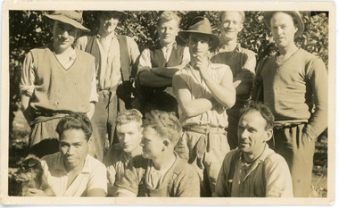
Photograph, Clint Rowse and Staff
John Lundy-Clarke grew up in the Kalorama/Mt Dandenong area and later in life (1972-74) began to write a comprehensive history of the area working from an original settlement map in an effort to cover all areas. John Lundy-Clarke has identified the photograph as being of Clint Rowse and Staff at Olinda Creek Valley in 1939. The workmen are: Back row from right: Bob Daly, Dud Page, Harry Dyson, Bill Cavell, Len Child, Ken Williams. Front row from right: Clint Rowse, Jack Clarke, Bernie Page, Jack Johnson (with dog). The Rowse family had extensive raspberry crops but later changed to flowers. Daisy Rowse married Hubert Jeeves. Black and white photograph showing a group of 10 workmen, one holding a dog.The names Lenny Child, Dyson, Page, Bob Daly, Jackie Johnston, J Clarke, Clint Rowse are handwritten on the back by John Lundy-Clarkelen child, bob daly, clint rowse, jack johnston, bill cavell, ken williams, jack clarke, dud page, bernie page -
 Mt Dandenong & District Historical Society Inc.
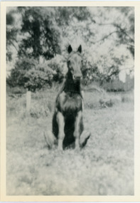
Photograph, Logan's Trick Horse
John Lundy-Clarke grew up in the Kalorama/Mt Dandenong area and later in life (1972-74) began to write a comprehensive history of the area working from an original settlement map in an effort to cover all areas. This photograph shows the 'trick horse' belonging to Robert Logan. Robert Logan settled on Lot 28 in 1896 and worked it until his death in 1936.Black and white photograph on a horse sitting in grass. Handwritten inscription on reverse by John Lundy-Clarke.1920 Logan’s trick horse on LOT 28 SECTION 1robert logan, logan, horse, kalorama, john lundy-clarke -
 Vision Australia
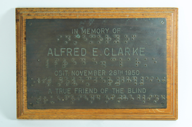
Photograph - Image, Alfred E Clarke plaque
Plaque commemorating the support of Alfred E. Clarke. A passionate supporter of Blind Cricket for 20 years, he was taken ill whilst umpiring a match and passed away at his Middle Park home on November 28th, 1950. Mr Clarke was one of South Melbourne's best cricketers in his youth, and after retirement continued his involvement in the sport he loved through committee and various management roles. He continued to watch matches with his friend Sam Morris - a fellow South Melbourne player who have gone blind - and became involved with the Blind Cricket Association, spending most weekends umpiring matches. Source: Record (Emerald Hill), Sat 2 Dec 1950, p4 "The Final Call" http://nla.gov.au/nla.news-article164499137Metal plaque attached to woodIn Memory Of Alfred E. Clarke Obit. November 28th 1950 A True Friend of the Blindassociation for the advancement of the blind, nameplates, victorian blind cricket association -
 Mt Dandenong & District Historical Society Inc.
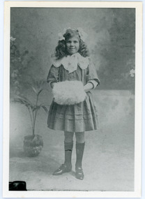
Photograph
Beatrice Myra Louise Wilson (Myra) married Edward John Price in 1930. According to John Lundy-Clarke Myra was the daughter of the man who rebuilt the Mt Dandenong State School in 1920, separating the school building from the school house.Black and white studio portrait of a young girl standing with her hands inside a fur muff. Handwritten inscription on reverse by John Lundy-Clarke Myra Wilson aged 10. Mrs E. John Price.myra wilson, myra price, edward john price, mt dandenong school -
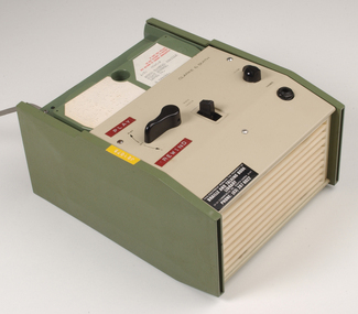
 Vision Australia
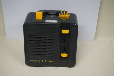
Equipment - Object, Clarke & Smith, Easiplay 2, 1990's
This Easiplay 2 model was produced by CSI (Clarke & Smith Industries) using a combination of overseas and locally made parts; however demand for compact discs was increasing by this time and the players were not financially viable. After the death of John Clarke in 1997 and the subsequent loss of it's major contract with RNIB, the company was wound up in 2004.Plastic rectangular grey coloured audio player with buttons for navigational controls, power cord and 3 buttons Clarke + Smith Model 1322 Serial number 9701-0011audio equipment, clarke and smith -
 Linton and District Historical Society Inc
Photograph, David Clarke
Black and white copy of original photograph of older gentleman posing wearing a wool suit with white shirt and striped tie, also wearing a buttonhole."Mr David Clarke Gordon Clarke's father."david clarke -
 Linton and District Historical Society Inc
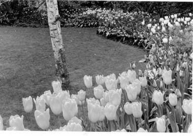
Photograph, Tulips in Clarke garden
Coloured photograph of flower display in a garden."Clarke's tulips".gardens, clarke family, gordon clarke, piggoreet west -
 Linton and District Historical Society Inc
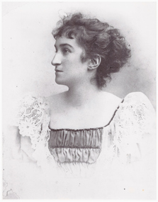
Photograph, Mrs. David Clarke
Black and white copy of original photograph of profile picture of a young lady wearing a dress with a ruched bodice and lace sleeves. Hair loosely pulled back in a bun."Mrs David Clarke (nee Retallick) Gordon Clarke's mother."mrs david clarke (nee retalick), gordon clarke -
 Mt Dandenong & District Historical Society Inc.
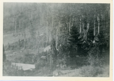
Photograph, View Over Roof of "Kalorama"
Taken in 1908, this photograph, though rather blurry, gives an indication of the location of the early settler properties in the valley in relation to one another. European trees have been planted at 'Kalorama' , the first home of Ellis Jeeves. John Lundy-Clarke grew up in the Kalorama/Mt Dandenong area and later in life (1972-74) began to write a comprehensive history of the area working from an original settlement map in an effort to cover all areas.Black and white photograph looking across hillside with large trees and rooftops visible. Handwritten description on reverse by John Lundy-Clarke.1908 View over roof of “Kalorama” towards the Falls. Paynter’s house on LOT 29 in low centre (now “Yosemite”). Pimms house on LOT 19 above Paynters and beyond scrub. Logan’s house faint above left of “Kalorama”. Dunbar’s LOT 20 beyond Pimm’s orchard. Gum trees on right were on Price’s LOT 19 now Tosari Rd area. It was one of these that figured in the episode of the runaway log in 1930. It leaped in one bound over Barbers Road at bottom of scrub in centre of picture then over Logan’s house.kalorama, ellis jeeves, jeeves -
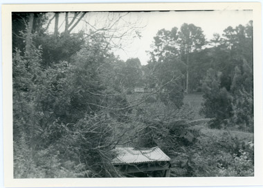
 Mt Dandenong & District Historical Society Inc.
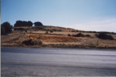
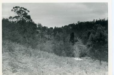
Photograph, View Up Valley Towards Kalorama Gap 1973
John Lundy-Clarke grew up in the Kalorama/Mt Dandenong area and later in life (1972-74) began to write a comprehensive history of the area working from an original settlement map in an effort to cover all areas. This photograph would have been taken to show the changes in the area over the years. Kalorama Gap is now called Five Ways. 'Kia-Ora ' was a guest house built by George Barber. It is no longer standing.Black and white photograph showing a bush scene with a white car visible on the right. Handwritten inscription on reverse by John Lundy-Clarke1973 View up Valley towards Kalorama Gap from what was Crooks LOT 24. White car is on Barbers Road and site of “Kia Ora” is to right of it.kalorama, kalorama gap, five ways, barbers road, george barber, kia-ora -
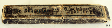 Flagstaff Hill Maritime Museum and Village
Domestic object - Razor, John Clarke Ltd, 1930s
In 1848, 43-year-old John Clarke launched a cutlery business in Harvest Lane in Neepsend, Sheffield UK. Clarke entered the trade late in life he was indenture and apprenticed to Octavius Twigg, a razor maker. Clarke was granted his Freedom in 1856 and began using the trademark 'NEVA'. By the 1860s, Thomas Clarke's son by his wife Elizabeth had joined the firm. When John Clarke died at his home at Augusta Place, Rock Street, Sheffield on 25 July 1873 (aged 68), he only employed six workmen. By 1881, Thomas had expanded this number to twenty. He sold a wide range of cutlery and was also an ‘emigration agent’, the Sheffield Independent, of 7th September in 1886 had an article published stating Thomas helped to recruit personnel from England for cutlery centers in America. In 1893 Clarke’s showroom displayed miniature knives from '5/16ths-inch long to the most expensive sportsman's knives, that were gold and silver mounted. Table knives and carvers were also manufactured (or factored). Agencies were opened in London, New York, and Melbourne. Besides ‘NEVA, the ‘EXPRESS’ and ‘RING’ marks were used on razors; and Clarke’s marketed the American ‘GEM’ safety razor. By 1901, the firm had moved to Mowbray Street, where its Mowbray Works overlooked the River Don. Thomas Clarke died at Harrogate on 26 April 1902, aged 62, and was buried in the same Burngreave cemetery as his parents. Thomas’s sons, John Roome Clarke (1860-1925) and Thomas Edward Clarke, were directors, another son George William Clarke was a shareholder. John Roome Clarke died on 3 February 1925, aged 64 his son, John Clarke, of Crimicar Lane, remained as the senior partner. Clarke’s was one of the last producers of hand-made pocket knives and it also produced a large output of sheath knives for scouting associations. The firm was liquidated in 1964, but the company name was resurrected and Its last address after 1980 was at 65 Garden Street Sheffield. The company trademark passed on to Meteor Industries and then to Egginton Ltd. Weber & Co: The Clarke company purchased or (factored) many of its blades for razors and knives from Weber & Co of Solingen Germany. The full name of the firm originally was Jowika Stahlwarenfabrik Eugen Weber & Altenbach KG. It was founded in Solingen prior to 1928, under the name Johann & Wilhelm Kleinewefers GMBH, Messerfabrik. JWK for short, hence JoWiKa. The company was sold to Eugen Weber in the 1930s. Weber was married to a woman named Altenbach, from a family that manufactured innovative low-priced pocketknives, as well as other cutlery items. In 1960 Weber opened a branch factory in Listowel Ireland. It was sold to Albert M. Baer of Imperial Schrade in 1978. The Listowel factory was closed about a year and a half before the U.S. Schrade factory closed in 2004 and the Jowika factory in Solingen had closed in 1984.An item with an interesting manufacturing history from the 1930s showing how one man can grow a business into a successful concern that made quality products that stand the test of time.Razor metal folding blade with horn handle in its original cardboard box Inscription Made by John Clarke and Son England. "Champion" razor. On box " The Champion 10/6d" and "Weber Lohmann & Co SOLINGEN".flagstaff hill, warrnambool, shipwrecked-coast, flagstaff-hill, flagstaff-hill-maritime-museum, maritime-museum, shipwreck-coast, flagstaff-hill-maritime-village -
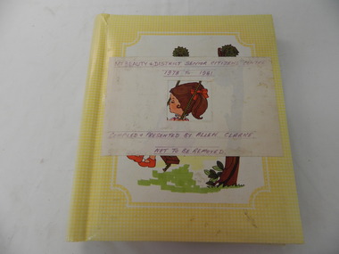 Kiewa Valley Historical Society
Photo Albums x 2 - Mt. Beauty Senior Citizens Centre, Mt Beauty & District Senior Citizens Centre 1978 - 1981 and 1982 to 1985. Compiled & Presented by Allen Clarke
These albums were put together by Allen Clarke, who worked for the State Electricity Commission of Victoria for over 40 years. He was also a member of the Senior Citizens Club. He collected theses press cuttings, put them in these albums and donated them to the Mt Beauty Senior's Club.1. Yellow cardboard photo album with colorful girl on swing in centre of front cover, overlayed with white paper label with purple printed title. Bound with metal spirax binding. The album contains press cuttings pertaining to the Mt Beauty & District Senior Citizen's Centre between 1978 and 1981. 2.Bluish with whitish coloured mountains (Alpine Scene) cardboard photo album with metal 'Photo Album' plaque stuck on the bottom right hand side. The album contains pres cuttings pertaining to the Mt Beauty & District Senior Citizen's Centre between 1982 and 1985.1. Mt Beauty & District Senior Citizens Centre / 1978 to 1981 on top of label. Compiled & Presented byu Allen Clarke / Not to be Removed on bottome of label 2. Nilsenior citizens; mount beauty; -
 Bacchus Marsh & District Historical Society
Map, Plan of the property of Messers Atkins and Clarke to be sold at the Mansion, Bacchus Marsh 19th April 1856. Copy 1
This plan of land allotments for sale indicates the property once owned by the Bacchus family in and around the township area of Bacchus Marsh. The Bacchus family sold their property in Bacchus Marsh to John Atkins and Robert Nalder Clarke in March 1851. Atkins and Clarke kept the property for a number of years until April 1856 when these allotments were put up for sale.This plan is almost identical to another copy held by the Bacchus Marsh and District Historical Society, VC Record 452, BMDHS collection). This plan, VC Record 707 Copy 1, contains a little more detail overall than VC Record 452 Copy 2, such as who did the survey work for the plan (R.C. Bagot) and who the selling agents were, (W.M. Tennent), and on the right side of the plan near the Lerderderg River is indicated the general area for a second parcel of land from this sale which is to be sold. There is also a compass illustration indicating north and south compass points.This is a very early land sales plan for the township of Bacchus Marsh and it therefore provides some clues as to how the early urban development of the township took place. Upon seeing the map in 1911 Bacchus Marsh Express newspaper editor Christopher Crisp wrote "The sale appears to have created the present township, which had a nucleus in earlier times further east", Express, 30 September, 1911, page 3.A single page paper plan showing allotments of land for sale. The subdivided land shown was owned by John Atkins and Robert Nalder Clarke, but previously owned by the Bacchus Family and was in and around their Manor House (Mansion) property in Bacchus Marsh.There are 5 portions of land further divided into numerous small portions. The land for sale is bounded by the present day streets of Main Street, Young Street, McFarland Street, Morton Streets, Crook Street, and part of the eastern section extends to the Lerderderg River. Scale: 8 chains to 1 inch The plan is pasted into a bound volume containing 76 maps or plans in total. BMDHS Loc: AR/B12/S4 Bacchus Marsh Township and Nearby Districts Maps Volume In-house Digital copies: BMDHS, Computer Network: Maps\Bacchus Marsh Township and Nearby Districts Maps VolumeHeading: Plan of the first portion of land. The property of Messers Atkins and Clarke situate at Bacchus Marsh. To be sold by W.M. Tennent & Co. at the Mansion on the Ground on Saturday the 19th April 1856. Below heading: Jas Ferguson, Lithographer On upper right side: Subdivided by R.C. Bagot London and Liverpool Chambers, Melbourne. 'Thos Taubman'. Post Office Stamp: BACCHUS MARSH VICTORIA MY 6, 63bacchus marsh victoria maps, bacchus family, land sales, manor house bacchus marsh -
Eltham District Historical Society Inc
Folder, Robert Clarke, 1860s
Folder of information on Robert Clarke, Queenstown, 1860srobert clarke -
Eltham District Historical Society Inc
Folder, William Clarke, 1850s
Folder of information on William Clarke, Eltham 1850swilliam clarke -
 Mt Dandenong & District Historical Society Inc.
Photograph, Hand's Pine Tree in Kalorama Reserve
Kalorama Memorial Reserve was once the location of 'Mountain Grange', the property of Thomas and Eliza Hand. The pine tree pictured was reputedly planted by Mrs Eliza Hand in the 1880s. Thomas Hand died in 1888 when he was thrown from his horse on Inverness Road. The photograph was taken in 1974 and the pavilion pictured is no longer there. John Lundy-Clarke grew up in the Kalorama/Mt Dandenong area and later in life (1972-74) began to write a comprehensive history of the area working from an original settlement map in an effort to cover all areas.Black and white photograph showing a large pine tree behind a pavilion. Handwritten description on reverse by John Lundy-Clarke.Hand’s pine tree in Kalorama reserve. Planted 1874 approx. Pictured 14-3-73.kalorama memorial reserve, kalorama oval, mountain grange, thomas hand, eliza hand, pine tree, pavilion -
 Mt Dandenong & District Historical Society Inc.
Photograph, View of the Kalorama Valley c1905
John Lundy-Clarke grew up in the Kalorama/Mt Dandenong area and later in life (1972-74) began to write a comprehensive history of the area working from an original settlement map in an effort to cover all areas. This photograph c1905 is looking up from George Barber's house 'Forest Edge' on Barbers Road. 'Forest Edge' was built c1898 and was the home of George Barber and his wife Sarah Ann (nee Richardson). The buildings in the foreground are the stables and hayshed.Black and white photograph showing two small buildings in the foreground with cleared hills behind. Handwritten decription on back by John Lundy-ClarkeA 1905 view of the Kalorama Valley towards the Gap. Barbers stables in foreground with hayshed on left. Tait’s house in centre of picture with Logans in the same fold above the hayshed. “Kalorama” is centre of Gap with Paynter’s “Iona” on its left with stables to its left. It was from one of these trees on the top left that the runaway log was cut that leaped over Barbers Road (at the top edge of the cleared land) then over Logan’s house in one bound in 1930.george barber, sarah ann barber, john lundy-clarke, forest edge -
 Phillip Island and District Historical Society Inc.
Photographs, 1920's
325-07 Inscription on back of photograph. "Violet Clarke, sister of Jimmy and Jack Clarke all born at San Remo 1880's - 90's. Violet married a Mr Sinclair and was the mother of Laurie. Jimmy & Jack Clarke's nephew, Laurie, like his uncles, never married." 325-08 Inscription on back of photograph. "Violet was the sister of twins Jimmy & Jack Clarke" 325-07 & 08. Hand coloured sepia portraits of Violet Clarke. 325-09. Sepia photograph of Violet Clarke's wedding.325-09. "25 years ago". Violet Clarke's marriage to ? Sinclair. Best man is probably Jack Clarke, brother Jimmy was most likely at sea.violet clarke, jack clarke, arthur woodley -
 Mt Dandenong & District Historical Society Inc.
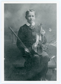
Photograph, Edward John Price aged 14
John Lundy-Clarke grew up in the Kalorama/Mt Dandenong area and later in life (1972-74) began to write a comprehensive history of the district working from an original settlement map in an effort to cover all areas. Edward John Price (1898 - 1974) was the son of early settlers on Lot 1 of the Village Settlement Edward Joseph Price and Annie (nee Ross) Price. He was the brother of Charles and Kathleen Price. Edward John married Myra Wilson in 1930.Black and white studio portrait showing well groomed boy holding a violin. Reverse of photograph has handwritten description by John Lundy-Clarke.Edward John Price aged 14. Son of Edward Joseph Price and Annie Ada nee Ross. Farmer, sawmiller, logging contractor,. proprietor of shop at Kew Junction 1935. Quarry master (Kilsyth). Father of Alan and Eddie J. A daughter died young. Married Myra Wilson 1930. Died 1974.edward john price, edward joseph price, annie price, annie ross, kathleen price, charles price -
 Linton and District Historical Society Inc
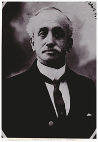
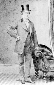
Photograph, Mr. John Clarke
Copy of original photograph. Photograph shows a gentleman wearing suit and top hat, standing with left hand leaning on arm of a chair, right arm crooked at waist height."Mr John Clarke of Piggoreet Station".mr john clarke, piggoreet station -
 Bacchus Marsh & District Historical Society
Map, Plan of the second portion of the property of Messers Atkins and Clarke situate at Bacchus Marsh 1856
This plan of land allotments for sale indicates part of the property once owned by the Bacchus family in and around the township area of Bacchus Marsh. The Bacchus family sold their property in Bacchus Marsh to John Aitkins and Robert Nalder Clarke in March 1851. Aitkins and Clarke kept the property for a number of years until April 1856 when these allotments were put up for sale.This is a very early land sales plan for agricultural land close to the township of Bacchus Marsh. It therefore provides some clues as to how the early urban development of the township and agricultural development of the nearby area took place. Upon seeing the map in 1911 Bacchus Marsh Express newspaper editor Christopher Crisp wrote "The sale appears to have created the present township, which had a nucleus in earlier times further east", Express, 30 September, 1911, page 3.A single page paper plan showing allotments of land for sale. The subdivided land shown was owned by John Aitkins and Robert Nalder Clarke, but previously owned by the Bacchus Family and was in and around their Manor House (Mansion) property in Bacchus Marsh. This plan shows allotments in the second portion of land to be sold which was located east of the Manor House on the eastern side of the Lerderderg River. The land for sale was made up of 15 allotments. The plan is pasted into a bound volume containing 76 maps or plans in total. BMDHS Loc: AR/B12/S4 Bacchus Marsh Township and Nearby Districts Maps Volume In-house Digital copies: BMDHS, Computer Network: Maps\Bacchus Marsh Township and Nearby Districts Maps Volumebacchus marsh victoria maps, bacchus family, land sales, manor house bacchus marsh -
 Running Rabbits Military Museum operated by the Upwey Belgrave RSL Sub Branch
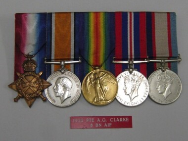
Medals, Medals of PTE Arthur Ernest Clarke
WW1 Served in Gallipoli & France WW2 Militia The 1914 Star This bronze medal award was authorized by King George V in April 1917 for those who had served in France or Belgium between 5th August 1914 to midnight on 22nd November 1914 inclusive. The reverse is plain with the recipient's service number, rank, name and unit impressed on it. It should be remembered that recipients of this medal were responsible for assisting the French to hold back the German army while new recruits could be trained and equipped. Collectively, they fully deserve a great deal of honour for their part in the first sixteen weeks of the Great War. There were approximately 378,000 1914 Stars issued. The British War Medal, 1914-18 The silver or bronze medal was awarded to officers and men of the British and Imperial Forces who either entered a theatre of war or entered service overseas between 5th August 1914 and 11th November 1918 inclusive Approximately 6.5 million British War Medals were issued. Approximately 6.4 million of these were the silver versions of this medal. The recipient's service number, rank, name and unit was impressed on the rim. The Allied Victory Medal Approximately 5.7 million victory medals were issued. The recipient's service number, rank, name and unit was impressed on the rim. The 1939-45 Star Awarded for service as follows: • Army - awarded for six months service in an operational command during the period 3 September 1939 to 2 September 1945. The War Medal 1939-45 Awarded to members who served full-time in operational or non-operational service between 3 September 1939 and 2 September 1945. Clarke SN 1703 8 Btn AIF