Showing 80 items
matching lyell street
-
 Marysville & District Historical Society
Photograph (Item) - Colour photograph, Travel Victoria, 2004
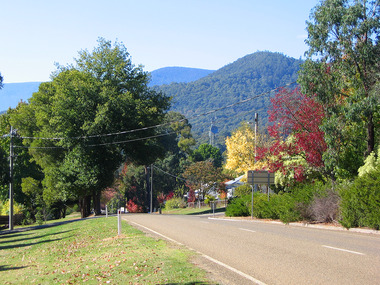
... with Lyell Street.... Street towards the corner with Lyell Street. Photograph Colour ...A colour photograph of Murchison Street in Marysville in Victoria.A colour photograph of Murchison Street in Marysville in Victoria.murchison street, marysville, victoria, photograph -
 Marysville & District Historical Society
Photograph (Item) - Colour photograph, Travel Victoria, Unknown
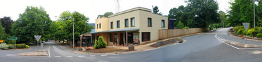
... lyell street... lyell street marysville victoria top shop photograph 2009 black ...A colour photograph of the Top Shop in Marysville in Victoria.A colour photograph of the Top Shop in Marysville in Victoria. This building was badly damaged in the 2009 Black Saturday bushfires.murchison street, lyell street, marysville, victoria, top shop, photograph, 2009 black saturday bushfires -
 Marysville & District Historical Society
Photograph (Item) - Colour photograph, Travel Victoria, Unknown
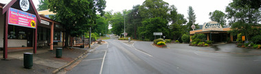
... lyell street... of Murchison Street in Marysville in Victoria. murchison street lyell ...A colour photograph of Murchison Street in Marysville in Victoria.A colour photograph of Murchison Street in Marysville in Victoria.murchison street, lyell street, marysville, victoria, photograph -
 Marysville & District Historical Society
Photograph (Item) - Black and white photograph, 1930s-1940s
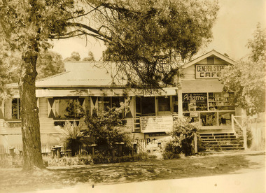
... lyell street... was on the corner of Murchison and Lyell Streets. Then in later years ...A black and white photograph of the General Store and Cafe in Marysville in Victoria.A black and white photograph of the General Store and Cafe in Marysville in Victoria. In 1920 this building once housed the old Marysville Post Office. It stood next to a blacksmith's shop which was on the corner of Murchison and Lyell Streets. Then in later years it became the Ski Run Cafe and the Pine Tree Tea Rooms.1930/40s Early Days/ in Marysvillemarysville, victoria, pine tree tearooms, marysville post office, post office, murchison street, lyell street, ski run cafe -
 Greensborough Historical Society
Poster - Planning Document, City of Heidelberg, Subdivision Plan # G 27, Greensborough and Diamond Creek, 1922 and 1963
... , Lyell Street, Nell Street, McDowell Street, 1922. Plan 2: Henry..., Lyell Street, Nell Street, McDowell Street, 1922. Plan 2: Henry ...Plan of Subdivisions in City of Heidelberg: Side 1: 2 plans, Parish of Keelbundoora: plan 1: Henry Street, Vermont Avenue, Lyell Street, Nell Street, McDowell Street, 1922. Plan 2: Henry Street, Nepean Street, Charles Street, 1922. Side 2: 2 plans Parish of Nillumbik, Portion 13: Plan 1: Diamond Creek Road, Delfin Crescent, Ridge Road, 1963. Plan 2: Kinglake Road, Eltham Road, 1963.An example of hard copy subdivision plans from the Greensborough area. Mainly from the Shire of Diamond Valley era (1964-1994).Plan (2 sided) mounted on heavy card. Contains 2 sheets pasted together.Stamped and handwritten Council permissions, dates and other details.subdivision plans, city of heidelberg -
 The Beechworth Burke Museum
Geological specimen - Chalcopyrite
This specimen originated from Mount Lyell on the west coast of Tasmania, where a large group of open cut and underground copper-silver-gold mines began operating in 1883. Between 1893-1994, the Mt Lyell Mining and Railway Company were responsible for operations. The Mt Lyell copper-gold mines produce some excellent crystallised specimens of chalcopyrite and other minerals. The deposits are generally considered to be of Cambrian volcanic origin, but there are indications of Devonian granitic influence on the ores, plus local remobilisation during Devonian deformation. Over 120 million tonnes of ore was produced from several workings, including the main Prince Lyell mine and the North Lyell mine, which was also of great importance. The Mount Lyell mines have a long history of human and environmental disasters, including the 1912 North Lyell fire that killed 42 miners, and two separate incidents in 2013 in which three people lost their lives. The environmental impacts from this complex of mines are extensive, with waste tailings and heavy metal contamination flowing directly into the King and Queen River catchments. In 1954, the eminent Australian historian, Geoffrey Blainey, published 'The Peaks of Lyell' which delves into the history of the 1912 North Mount Lyell Disaster.Chalcopyrite does not contain the most copper in its structure relative to other minerals, but it is the most important copper ore since it can be found in many localities and occurs in a variety of ore types. The brassy-yellow colours in Chalcopyrite mean it is often confused with pyrites and gold, leading to use of the term, "fool's gold." Chalcopyrite has been the primary ore of copper since smelting began five thousand years ago. This specimen is part of a larger collection of geological and mineral specimens collected from around Australia (and some parts of the world) and donated to the Burke Museum between 1868-1880. A large percentage of these specimens were collected in Victoria as part of the Geological Survey of Victoria that begun in 1852 (in response to the Gold Rush) to study and map the geology of Victoria. Collecting geological specimens was an important part of mapping and understanding the scientific makeup of the earth. Many of these specimens were sent to research and collecting organisations across Australia, including the Burke Museum, to educate and encourage further study.This hand sized solid mineral specimen has shades of brass-yellow with spots of iridescent green-black tarnish. Chalcopyrite is a copper iron sulphide mineral and a major ore of copper common in sulphide veins and disseminated in igneous rocks. Chalcopyrite has a hardness of 3.5-4 on the Mohs Scale. It is a member of the tetragonal crystal system and has metallic lustre and opaque transparency.burke museum, beechworth, indigo shire, beechworth museum, geology, geological specimen, chalcopyrite, copper pyrites, copper mining, tasmanian geology, mount lyell, mount lyell mines, fools gold, mohs scale, crystals, minerals, historical geological collection, victorian geological survey, a.r.c selwyn, gold rush, van diemans land -
 Federation University Historical Collection
Book - Scrap Book, Ballarat School of Mines Scrap Book, 1924 - 1929, c1931
The Ballarat School of Mines was a predecessor institution of Federatin University Australia. The scrap books were kept by the librarians and related to topics of interest to the Ballarat School of Mines, its students and its staff. 17 December 1954 - Ballarat Junior Technical School Headmaster's Report 05 February 1925 - Ballarat School of Mines Museum closure 25 February 1925 - War Trophies Museum 06 May 1925 - Ballarat's Museum. Where is it? Some Interesting Facts 14 May 1925 - White Flat Reserve 21 June 1928 - Ballarat School of Mines Procession 14 March 1929 - Mr A.D.R. Galloway - An Australian Abroad - Tragic end. 1929 - Technical Education 17 October 1929 - Agricultural Engineering 15 February 1930 - Ballarat School of Mines Student Association 20 February 1930 - 61s Annual Meeting of the Ballarat School of Mines 02 June 1930 - R. Young in Belgium and visits battlefields including Hill 60. 19 February 1931 - School Hostel Suggested 14 April 1931 - Frank Pinkerton Obituary 15 October 1921 - Life at Mt Isa (E. Loveland) 18 February 1932 - Discussion on Teachers College (Ballarat Teachers' College) 11 July 1931 - Phoenix Model Locomotive donation to the Ballarat School of Mines 06 May 1932 - The Mt Isa Country 11 Oct 1932 - Death of F.W. Alsopp (former SMB student) 21 January 1933 - Education In Victoria: Will a New Era Open 28 September 1933 - New Teaching System Explained by the Minister 17 February 1934 - Trip to New Guinea (A.F. Heseltine) 19 April 1934 - Early Ballarat - Address by Nathan Spielvogel 30 August 1934 - Ballarat Junior Technical School Tennis Court 23 August 1934 - Welding plant and Battery 17 June 1935 - Men about Town - A.F. Heseltine 21 June 1935 - Vocational Guidance 16 July 1935 - Ballarat School of Mines (history) 03 August 1935 - Men About Town - William H. Middleton 10 August 1935 - A.E.C. Kerrballarat school of mines, martha pinkerton, scrap book, a.w. nicholson, john lynch (junior), mount lyell, leslie evans, leslie blake evans, herald shield for athletics, ballarat school of mines museum, motor mechanics' classes for ladies, farm engineering, villers bretonneux carvings, trengrove, museum, port pirrie, j.i. simpson, reuben s. russelll, ballarat technical art school, charles harvey, elliott gower, la gerche, c. curnow, applied art, macroberston scholarship, ballarat school of mines procession, rag, vale park tree planting, smb ball, pottery classes, delineascope, mica smith scholarship, james peart, burma mnies, smb excursion to western australia, kalgoorlie, elsie mckissock, war trophies, warwick smith, spencer street bridge, war museum, richard j. young, alfred mica smith obituary, reginald callister, john rowell, sewerage installation, h.h. smith, w.h. middleton, olive scott, dolly whitehead, vale park, ballarat war museum opening, repatriation classes, sewerage at the ballarat school of mines, australian coals, j.p. ellsworth, yallourn, w.g. walker, reunion, norfolk island pine, mica smith memorial, jessice smith, harry fern, t. henderson, bhp, john adam, ols students' association, l.b. curnow, laura crouch, signwriting, excursion, port pirrie excursion, albert potter, pearl fricke, technica school sports, percy trompf, ballarat school of mines battery, albert mclean, a.d.r. galloway, alan douglas richard galloway, r.j. young, alan ludbrook, r. timpe, ballarat ironworkers and polytechnic association, h. jolly, carpentry, harold jolly, millinery classes, phoenix model locomotive, s.j. morgan, r.d. bannister, juvenile industrial exhibition, w.h. shaw, j.c. winds, f.h. davis, h.r. worland, w.t. magee, l. george, l. balhausen, white flat oval, resue from yarrowee creek, e. berriman, ballarat teachers' college, reg mcconnell, mount lyell co, munro reaper, munro reaper model, weaving classes, mervyn trimmings, briquette dust, edna findlay, jean rogers, n. mccallum, jessie glass, classroom ventilation, art metal, charles fenner, levi molyneux, olice scott, poster competition, kerr grant, w.h. steane, h. caddy, colvin smith, claude creelman, robert colins, stan hillman, n.c. heathcote, egg collection, john alexander, nornie gude, charles deane, graham hopwood, roswald john dart, max wilson, new battery, jess hopwood, william middleton, a.e.c. kerr, hand weaving classes, m. martin, a.h. leeson, mona rogerson, lorna bailey, prospectors classes, edwin robinson, kalgoorlie vist, railway locomotive -
 Federation University Historical Collection
Booklet, Ballarat School of Mines Student's Magazine, Second Term, 1903, 1903
Table of contents: Editorial, Bad language in Sturt Street, The Greatest Mining Camp on Earth, A method for estimating arsenic in ores, S.M.B. camp, Some engineering experiences, Some reminiscences of W. A., Science notes, Notes on Mt Lyell, Students afield, Estimation of titanium, Illustration - students' abroad - No. 1, Past students, Ballarat scientific and literary society, Students' reunion, News and notes, Special notice, A sentimental ditty, International atomic weights. Pale gray booklet of 20 pagesballarat school of mines, students' magazine, o. e. jager, obituary, alfred gersham johnston, w. b. blyth, s. b. vial,, d. w. b. arthur, s. radcliffe, r. j. allen, tom vincent, angus gibson, lew westcott, reg robin, r. a. suter, b. nicholls, cecil eeles, gerald young,, harold edgar, fred cooper, h. l. krause, len seal, r. m. stubbs, dave lilley, e. w. trend, austin woods, j. phillipson, j. brangan, e. prendergast,, w. j. lakeland, w. a. gosman, a. basil reid, students' reunion, alfred mica smith, dr salmon, j. b. pearson, e. shew, j. m. currie, h. alston,, h. irwin, f. j. martell, a. m. ritchie, professor dawbarn, a. m. ritchie, t. s. hart, j. a. reid, a. e. kerr, a. gillespie, thomas hart, frederick martell -
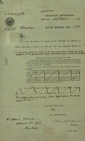
Bendigo Historical Society Inc.
Map - LYELL : COUNTY OF BENDIGO, 24-10-84
Map. Lyell, County of Bendigo, Eppalock, Sedgwick, Sutton Grange, Hawkestone, Kimbolton, Coliban River, Myrtle Creek. State School. Photo-Lithographed at the Department of Lands and Survey, Melbourne by J. Noune, 24-10-84. (number 71 in map cupboard 1)J. Nounemap, bendigo, lyell -
Bendigo Historical Society Inc.
Map - LYELL : COUNTY OF BENDIGO, 24-9-07
Map. Lyell, County of Bendigo, Sedgwick, Sutton Grange, Hawkestone, Kimbolton, Eppalock, Myrtle Creek, Coliban River. Photo-Lithographed at the Department of Lands and Survey, Melbourne by T.F. McGauran, 24-9-07, Price 1/-. (number 70 in map cupboard 1)T.F. McGauranmap, bendigo, lyell -
Bendigo Historical Society Inc.
Map - KIMBOLTON : COUNTY OF BENDIGO, 1966
Map. Kimbolton, County of Bendigo. Eppalock, Lyell, Knowsley, Langwornor, Redesdale, County of Dalhouse, County of Rodney, Campaspe River, Coliban River,By authority A.C.Brooks, Government Printer, Melbourne. Drawn and reproduced at the Department of Lands and Survey, Melbourne, 1966, Price $1.00 (number 65 in map cupboard 1)A.C. Brooks, Government Printer, Melbourne.map, bendigo, kimbolton -
Bendigo Historical Society Inc.
Map - CAMPBELL COLLECTION: BENDIGO AND DISTRICT MAPS, 8-6 29
Map. Kimbolton, Parishes of Kimbolton and Lyell, scale 20 chains to 1 inch. Area by Plamimeter 6258 acres. Coliban River, Knowsley, Strathfieldsaye 10 1/2 miles. Prepared in W.P.B. from Parish and Assessor's Plans. G.W.Latimer 8-6-29. (number 393 in map cupboard 1)G.W.Latimermap, bendigo, allotments -
Bendigo Historical Society Inc.
Map - CAMPBELL COLLECTION: BENDIGO AND DISTRICT MAPS
Map. Lyell, Parishes of Sedgwick, Eppalock and Lyell. Scale 20 chains to 1 inch. Total area 3307 acres. (number 387 in map cupboard 1)map, bendigo, country lands -
Bendigo Historical Society Inc.
Map - CAMPBELL COLLECTION: BENDIGO & DISTRICT MAPS, 5-4-28
Map. Sedgwick, Parishes of Strathfieldsaye, Lyell and Sedgwick. Scale 20 chains to 1 inch.Total area 5372 acres. Prepared in W.P.B. from C.l. and A. Plans by W.J. Galbraith. (number 374 in map cupboard 1)W.J.Galbraithmap, bendigo, agricultural lands -
Bendigo Historical Society Inc.
Map - CAMPBELL COLLECTION: BENDIGO AND DISTRICT MAPS
Map. Kimbolton, Parishes of Kimbolton and Lyell, scale 20 chains to 1 inch. Area by Planimeter 6258 acres. Knowsley. 10 1/2 miles to Strathfieldsaye. Campaspe River at bottom right of map. (number 365 in map cupboard 1)map, bendigo, allotments -
Bendigo Historical Society Inc.
Map - CAMPBELL COLLECTION: BENDIGO AND DISTRICT MAPS
Map. Sedgwick. Parishes of Strathfieldsaye, Lyell and Sedgwick. Scale 20 chains to 1 inch. (number 359 in map cupboard 1)map, bendigo, agricultural lands -
Bendigo Historical Society Inc.
Map - CAMPBELL COLLECTION: BENDIGO AND DISTRICT MAPS
Map. Lyell, Parishes of Sedgwick, Eppalock and Lyell. Scale 20 chains to 1 inch. (number 348 in map cupboard 1)map, bendigo, agricultural lands -
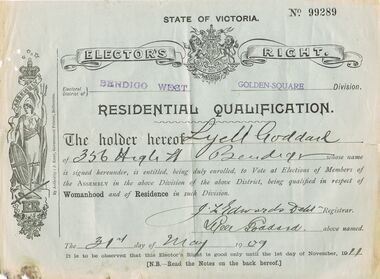 Bendigo Historical Society Inc.
Document - 'ELECTOR'S RIGHT': CERTIFICATE OF RESIDENTIAL QUALIFICATION, 1909
'Elector's Right' - Certificate of Residential Qualification for Lyell Goddard, Bendigo West. Entitled to vote ''in respect of Womanhood and of Residence'' in the Golden Square Division, 1909.person, individual, lyall goddard, womanhood and resistance, golden square division. -
Bendigo Historical Society Inc.
Map - SUTTON GRANGE : COUNTY OF BENDIGO, 21-7-22
Map. Sutton Grange, County of Bendigo, County of Talbot, Mandurang, Ravenswood, Harcourt, Faraday, Hawkestone, Lyell, Sedgwick, Myrtle Creek, Victorian Water Supply - Main Line of Aquaduct from Malmsbury to Sandhurst. By authority A.J. Mullett, Government Printer, Melbourne. Photo-Lithographed at the Department of Lands and Survey, Melbourne by W.J. Butson 21-7-22. Price 1/-. (number 124 in map cupboard 1)A.J. Mullett, Government Printer, Melbourne.map, bendigo, sutton grange -
Bendigo Historical Society Inc.
Map - SEDGWICK : COUNTY OF BENDIGO, 1963
Map. Sedgwick, County of Bendigo, Strathfieldsaye, Mandurang, Sutton Grange, Lyell, Eppalock County of Talbot Border. By authority A.C. Brooks, Government Printer, Melbourne. Drawn and reproduced at the Department of Lands and Survey, Melbourne.1963, Price 2/-. (number 30 in map cupboard 1)A.C. Brooks, Government Printer, Melbourne.map, bendigo, sedgwick -
Bendigo Historical Society Inc.
Map - SEDGWICK : COUNTY OF BENDIGO, 18-12-20
Map. Sedgwick, County of Bendigo,Strathfieldsaye, Mandurang, Sutton Grange, Lyell, Eppalock. Photo-Lithographed at the Department of Lands and Survey, Melbourne by W.j. Butson 18-12-20, Price 1/-. By authority A.J.Mullett, Government Printer, Melbourne. (number 29 in map cupboard 1)A.J. Mullett, Government Printer,Me;bourne.map, bendigo, sedgwick -
Bendigo Historical Society Inc.
Map - REDESDALE : COUNTY OF BENDIGO, 25 -10-77
Map. Redesdale, County of Bendigo, County of Dalhousie, County Of Talbot, Lyell, Kimbolton, Langwornor, Spring Plains, Glenhope, Emberton, Metcalfe, Hawkestone, River Coliban, Campaspe River, Back Creek. Photo-Lithographed at the Department of Lands and Survey, Melbourne by J. Noune, 25-10-77. Compared with original plans 12-11-78 M. Kemp. J.C.Kelsh, Draughtsman April 1876. Examined by E. Downward, 5-6-77. (number 121 in map cupboard 1)J. Nounemap, bendigo, redesdale -
Bendigo Historical Society Inc.
Map - REDESDALE : COUNTY OF BENDIGO, 24-12-24
Map. Redesdale, County of Bendigo, County of Dalhousie, Kimbolton, Langwornor, Spring Plains, Glenhope, Emberton, Metcalfe, Hawkestone, County of Talbot, Campaspe River, Back Creek, River Coliban, Lyell. By authority H.J. Green, Government Printer, Melbourne. Photo-Lithographed at the Department of Lands and Survey, Melbourne by W.J. Butson, 24-12-24, Price 1/-. (number 120 in map cupboard 1)H.J. Green, Government Printer, Melbourne.map, bendigo, redesdale -
Bendigo Historical Society Inc.
Map - CAMPBELL COLLECTION: BENDIGO AND DISTRICT MAPS, 6-4-28
Map. Sedgwick, Parishes of Strathfieldsaye, Lyell, and Sedgwick. Scale 20 chains to 1 inch. Total area 5372 acres. Prepared in W.P.B. from C.L.and A. Plans by W.J.Galbraith 6-4-28. (number 400 in map cupboard 1)W.J.Galbraith.map, bendigo, agricultural lands -
Bendigo Historical Society Inc.
Map - CAMPBELL COLLECTION: BENDIGO AND DISTRICT MAPS, 1963
Map. Sedgwick, County of Bendigo. Scale 20 chains to 1 inch. Strathfieldsaye, Eppalock, Lyell, Mandurang, Sutton Grange, County of Talbot. By Authority A.C. Brooks,Government Printer, Melbourne. Drawn and reproduced at the Department of Lands and Survey, Melbourne.1963. Price 2/-. (number 405 in map cupboard 1)A.C. Brooks, Governmenr Printer, Melbourne.map, bendigo, allotments -
Bendigo Historical Society Inc.
Map - BENDIGO, 1916
Map. Bendigo, Gunbower, Gladstone, Talbot, Dalhousie, Rodney, Jarklan, Calivil, Hayanmi, Mitiamo, Wanurp, Pannoobamawm, Bamawm, Millewa, Ballendella, Janiember West, Janiember East, Pompapiel, Talambe, Dingee, Milloo, Pannoomilloo, Rochester West, Yarrayne, Salisbury, Yallook, Tandarra, Kamarooka, Warragamba, Diggorra, Minto, Bridgewater, Yarraberb, Neilborough, Whirrakee, Egerton, Elmore, Nolan, Goornong, Bagshot, Huntly, Derby, Leichardt, Nerring, Tarnagulla, Woodstock, Marong, Sandhurst, Wellsford, Bendigo, Axedale, Strathfieldsaye, Eppalock, Kimbolton, Lyell, Sedgwick, Mandurang, Lockwood, Ravenswood, Shelbourne, Laanecoorie. Price 3/-. Smaller map of State of Victoria. Lithographed at the Department of Lands and Survey, Melbourne. 1916. Scale : Two miles to one inch. Map was in book form. (number 62 in map cupboard 1)map, bendigo, bendigo -
Bendigo Historical Society Inc.
Map - EPPALOCK : COUNTY OF BENDIGO, 2-11-14
Map. Eppalock, County of Bendigo,Lyell, Sedgwick, Strathfieldsaye, Axedale, Knowsley, Kimbolton. Photo-Lithographed at the Department of Lands and Survey, Melbourne by W.J. Butson, 2-11-14. Price 1/-. (number 39 in map cupboard 1)W.J. Butson.map, bendigo, eppalock -
Bendigo Historical Society Inc.
Map - HAWKESTONE : COUNTY OF BENDIGO, 7-11-15
Map. Hawkestone, County of Bendigo, County of Talbot, Lyell, Sutton Grange, Redcastle, Elphinstone, Metcalfe, Coliban River, Myrtle Creek. Albert J. Mullett, Government Printer, Melbourne. Photo-Lithographed at the Department of Lands and Survey, Melbourne by W.J. Butson,7-11-15. Price 1/-. (number 111 in map cupboard 1)Albert J. Mullett, Government Printer, Melbourne.map, bendigo, hawkestone. -
Bendigo Historical Society Inc.
Map - HAWKESTONE : COUNTY OF BENDIGO, December 1953
Map. Hawkestone, Parish, County of Bendigo, County of Talbot, Sutton Grange, Redesdale, Faraday, Elphinstone, Metcalfe, Lyell, Coliban River, Myrtla Creek. By Authority W.M. Houston, Government Printer. Drawn and reproduced at the Department of Lands and Survey, Melbourne. December 1953. Price 2/-. (number 99 in map cupboard 1)W.M. Houston, Government Printer.map, bendigo, hawkestone. -
Bendigo Historical Society Inc.
Map - HAWKESTONE, COUNTY OF BENDIGO, December 1953
Map, Hawkestone, County of Bendigo, County of Talbot, Sutton Grange, Redesdale, Lyell, Myrtle Creek, By authority W.M.Houston, Government Printer. Drawn and Reproduced at the Dept. of Lands and Survey, Melbourne, Victoria.December 1953. Price 5/-. (number 98 in map cupboard 1)W.M.Houston, Governmemt Printer.map, bendigo, hawkestone.