Showing 50 items
matching main street land allotments
-
 Ringwood and District Historical Society
Flyer, Land Sale Advertisement - State School Estate, Ringwood, Victoria - 1923
The date of the flyer as circa 1920 can be estimated from the references to the (decision on) "electrification of the Croydon Railway Line" which eventually occurred in 1923, letting of tenders for the state school building which opened in 1924, and the "proposed new railway station" (East Ringwood) which opened in 1925, Advertisement for State School Estate, Ringwood - 26 residential allotments for sale near East Ringwood State School development site and 7 minutes walk from proposed new railway station (East Ringwood). Includes location map and terms of sale.Locality plan includes King Street and Government Roads (Later Everard Road, Holland Road, Purser Avenue, and Charles Street). (Agents) J.B. McAlpin, Estate Agent and Subdivisional Manager, Ringwood (Opposite Station), and F.V. Parker, Estate Agent, Main Street, Ringwood. -
 Ringwood and District Historical Society
Flyer, Land Sale Advertisement - Sunbeam Estate, East Ringwood, Victoria - circa 1930
Folded double-sided page advertising private sale of 48 residential allotments, with location map, terms of sale, and details of local features and services. Locality plan includes Holland Road, Everard Road, Sunbeam Avenue, Mount Dandenong Road, and Lilydale Road (later Old Lilydale Road). (Agents) Phillips & Nicholson, 59 Swanston Street, Melbourne, (Phone) Central 10907, in conjunction with C.E. Carter, Bank Chambers, Main Street, Ringwood, Telephone Ringwood 24. -
 Bendigo Historical Society Inc.
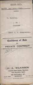
Document - H.A. & S.R. WILKINSON COLLECTION: CONTRACT OF SALE
Conditions of sale by private contract dated 5th July, 1941 between B. Hocking (seller) and Mrs. I.F. Stephenson (buyer) for land situate 25 Reginald Street, Bendigo being Crown allotment 7 section 104C land described in certificate of title volume 2684 folio 536778, together with 5-roomed weatherboard dwelling and all sundry. Also all electric globes and shades, all wire doors and screens and ''Main'' gas stove connected in place of present gas stove. Price 400 pounds. This is the office copy, attached: copy of insurance policy and city of Bendigo rates notice and receipts of paymentsorganization, business, h.a. & s.r wilkinson real estate -
 Bendigo Historical Society Inc.
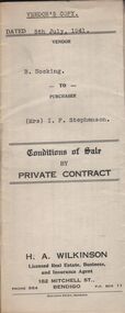
Document - H.A. & S.R. WILKINSON COLLECTION: CONTRACT OF SALE
Conditions of sale by private contract dated 5th July, 1941 between B. Hocking (seller) and Mrs. I.F. Stephenson (buyer) for land situate 25 Reginald Street, Bendigo being Crown allotment 7 section 104C land described in certificate of title volume 2684 folio 536778, together with 5-roomed weatherboard dwelling and all sundry. Also all electric globes and shades, all wire doors and screens and ''Main'' gas stove connected in place of present gas stove. Price 400 pounds.organization, business, h.a. & s.r wilkinson real estate -
 Whitehorse Historical Society Inc.
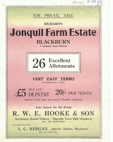
Document, Jonquil Farm Estate
Brochure of Richard's Jonquil Farm EstateBrochure of Richard's Jonquil Farm Estate featuring 26 allotments, 7 minutes from Blackburn Station.Brochure of Richard's Jonquil Farm Estate land subdivision, jonquil farm estate blackburn, laurel grove, blackburn, boongarry avenue, main street, linum street, hooke, r.w.e. & son, keegan, i.c. -
 Kew Historical Society Inc
Document - Urban Planning Document, City of Kew, City of Kew : Minimum Size of Allotment Required, 1945-1955
A document outlining the relevant by-laws produced by the City Of Kew to regulate the minimum size of allotments in Barkers Road, Burke Road, Cotham Road, Glenferrie Road and Studley Park Road, as well as in other streets more generally. The by-laws specify the size of allotments in which single unit dwellings, attached houses and maisonettes, and flats could be built. In the ‘main streets’ a minimum land area for single unit dwellings was 8,100 square feet, with an average frontage of 60’ and a depth of 135’. In other streets this was reduced to an overall size of 6,250 square feet, with an average dimensions of 50’ x 125’. In specifying the land area required by flats, different sizes were regulated for the construction of between two and six flats. Six flats at the time when the regulations were passed must have been the upper limit permitted. Understanding the size of land listed in imperial measurements can be a challenge. Within Australia, the so-called quarter acre block was approximately 11,000 square feet. Those specified in the by-laws would appear to be smaller. The document was pasted on the reverse of a subdivision plan in the collection.This is a rare (undated) document produced by the City of Kew defining how subdivision within the municipality should occur. The document was created to constrain unbridled speculation in subdivisions in the various parts of Kew and East Kew.Undated typed document, issued by the City of Kew (1921-1994) indicating the minimum size of allotment required in Barkers Road, Burke Road, Cotham Road, Glenferrie Road and Studley Park Road. The document is mounted on board and waterstained. It was presumably used by a real estate agent. [Formerly catalogued as MAP.0066].city of kew - by-laws and regulations, subdivisions - kew - studley park -
![Map, Plan of Town Allotments Bacchus Marsh [1891-1897]](/media/collectors/5e461d8021ea67224c82f2a1/items/66acc1c90c778f9f64a3daec/item-media/66acc3990c778f9f64a3e09b/item-fit-380x285.jpg) Bacchus Marsh & District Historical Society
Bacchus Marsh & District Historical SocietyMap, Plan of Town Allotments Bacchus Marsh [1891-1897]
This plan of town allotments in Lerderderg Street and Bennett Street also includes the location of many of the buildings, shops, businesses and houses which were present in the retail and business area of Bacchus Marsh in the 1890s. The precise date of the plan is not known but it must be sometime between 1891 and 1897. The Post Office and the Wesleyan Church are both shown on this plan. Both of these were constructed in 1890. The plan does not show the Baptist Church in Main Street which was constructed in 1898. Hence the date is sometime between 1891 and 1897.This plan of Bacchus Marsh is one of the most detailed visual representations of the location of shops, businesses and houses in the central part of Bacchus Marsh. It provides very precise locations of most of the shops and houses in the town in the 1890s. A single page paper plan showing allotments of land fronting Lerderderg and Bennett Street. Buildings, businesses and houses along most of the streets are identified by hand written annotations. Streets identified on plan: Lerderderg Street - Bennett Street - Main Street - Gell Street - Young Street - Graham Street. Physical boundaries of the map are: North border - Lerderderg Street - South border - Main Street - West border Gell Street - East border - Young Street. The plan is pasted into a bound volume containing 76 maps or plans in total. bacchus marsh victoria maps, shops bacchus marsh -
 Bacchus Marsh & District Historical Society
Map, Village allotments, Parish of Myrniong, County of Bourke
Myrniong is a village 9 kilometers west of Bacchus Marsh. Prior to 1863 the area was known as Blow's Flat. This map which was produced in 1903 and according to the catalogue record of this map held at the State Library of Victoria was based on an earlier map created in 1861. The early layout of streets for the village of Myrniong can be seen on this map. The streets shown are, Main Street, Hardy Street, Blow Street, Myrniong Street, Shuter Street, and Blackwood Street. An area marked as a reserve for a school can be seen between Hardy Street and Main Street.A single page paper map. A cadastral parish map of Myrniong in Victoria, showing numbered land allotments. Photo-lithographed at the Department of Lands & Survey, Melbourne, in 1903. Based on an original map created in 1861. The map is pasted into a bound volume containing 76 maps or plans in total. High resolution digital image stored on BMDHS computer network. Surveyed by John Hardy, Surveyor ; photo-lithographed at the Department of Lands & Survey, Melbourne by T.F. McGauran, 24.12.03myrniong parish plan, myrniong parish maps -
 Bacchus Marsh & District Historical Society
Map, Subdivision of the Manor House Property Bacchus Marsh c.1908
This land sales plan shows allotments of land offered for sale in the inner township area of Bacchus Marsh in 1908. The land put up for sale was from the estate of the late Mr and Mrs J.E. Crook. That being James Elijah Crook and his wife Harriet, (nee Athorn). The Crooks had been resident in Bacchus Marsh since the 1840s and were prominent members of the community. They were prominent in the business, social and civic affairs of the town and district. In the 1850s the Crooks acquired the Manor House and nearby land once owned by the Bacchus family. James Crook died in 1889. When Harriet Crook died in February 1908 their estate was offered for sale. This included the large stone home known as the Manor House and various parcels of land including around 50 allotments of land near the Manor House, bounded by Young, Lerderderg, Crook and Main Streets. Most of these allotments of land were sold in October 1908. The Manor House itself was passed in at the sale and continued to be owned by the Crook family for several decades after 1908.A single page map on a single page of a bound volume of maps. The map shows portions of land for sale from the subdivision of the Manor House property in Bacchus Marsh in 1908. The names of most of the buyers of the portions of land have been hand-written into the various allotments they purchased. The maps are pasted into a bound volume containing 76 maps or plans in total. High resolution digital image stored on BMDHS computer network. bacchus marsh victoria maps, land sales bacchus marsh, manor house bacchus marsh, crook family bacchus marsh -
 Ringwood and District Historical Society
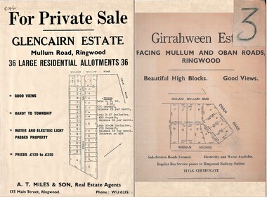
Document - Folder, Land Sale Advertisement, Glencairn Estate and Girrahween Estate, Ringwood - circa 1950s
Single sided advertisement for private sale of residential allotments - undated, circa 1950s.Subdivisions include Mullum Mullum Road,Glen Cairn Avenue (Glencairn), Oban Road, and Norman Avenue (later Hugh Street). Agent - A.T. Miles & Son, 175 Main Street, Ringwood, Phone WU 6215. -
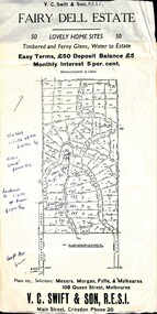 Ringwood and District Historical Society
Flyer, Residential Land Sale Sub-division - Fairy Dell Estate, Warranwood, Vic. - circa 1950s
Land sale advertisement for 50 home sites with map of Sub-division showing layout of streets and allotments, summary of local features and services and terms of sale, and copy of sectional map of Crown Allotments 20 & 21B Parish of Warrandyte also showing layout of Sub-division.Subdivision includes Grandview Grove (later Bemboka Road), Merrill Crescent and Kerry Road, Warranwood. Estate Agents - V.C. Swift & Son R.E.S.I., Main Street, Croydon, Phone 20. Solicitors - Morgan, Fyffe & Mulkearns, 108 Queen Street, Melbourne. Handwritten 1970s real estate price notations for some blocks. -
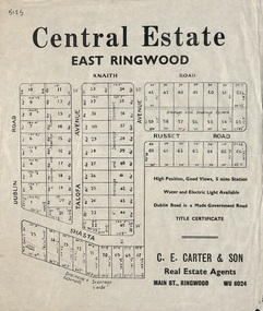 Ringwood and District Historical Society
Flyer, Land Sale Advertisement, Central Estate, East Ringwood - 1948
East Ringwood Central Estate auction sale of allotments previously advertised for Saturday October 23rd (1948). Victorian Collections reference 5138 refers.Single sided leafletSubdivision includes Dublin Road, Knaith Road, Talofa Avenue, Russet Road, and Shasta Avenue. Agent - C.E. Carter & Son, Main Street, Ringwood. WU 6024. -
 Bacchus Marsh & District Historical Society
Map, Maddingley Township, Parish of Parwan, circa 1890s
Maddingley is a locality or township within the broader township area of Bacchus Marsh. This map is not dated. However features in Maddingley which appeared in the 1880s and 1890s are present in the map, These include the Bacchus Marsh Railway Station and the Bacchus Marsh Showgrounds. The main residential and commercial area of Maddingley is shown on this map in an area bounded by Bacchus Street, Barry Street, Griffith Street and Maddingley Road. Other streets visible are Franklin Street, Inglis Street, Labilliere Street, McCrae Street, Moore Street and part of Station Street.A single page paper map showing land allotments, streets, rivers, creeks, park lands, the railway line and Bacchus Marsh railway station in the township of Maddingley. The map is pasted into a bound volume containing 76 maps or plans in total. bacchus marsh victoria maps, maddingley victoria maps, land use, maddingley victoria history -
 Bacchus Marsh & District Historical Society
Map, Maddingley Township, Parish of Parwan, County of Grant, 1856
Maddingley is a locality or township within the broader township area of Bacchus Marsh. This map is dated 1856 but is based on an earlier survey in 1843. The main area of Maddingley shown on this map is an area bounded by Bacchus Street, Moore Street, Griffith Street and Franklin Street. Other streets visible are Inglis Street, Labilliere Street, McCrae Street. The area to the east of Franklin Street is not sub-divided and is described as an 'alluvial flat. A single page paper map showing land allotments, streets, and natural watercourses in the township of Maddingley. The map is pasted into a bound volume containing 76 maps or plans in total. Two inscriptions: 1. A.J. Skene Surveyor, 1843. ; 2. Surveyor-General's Office Melbourne, Sept 6, 1856. (Lithographed by R. Meikle)bacchus marsh victoria maps, maddingley victoria maps, land use, maddingley victoria history -
 Bacchus Marsh & District Historical Society
Map, 'Map of Darley' circa 1877-1897
This map shows the early laid out streets and roads for the village of Darley and the main roads and streets in the central area of the township of Bacchus Marsh. The date of the map is not known. Landmarks indicated on the map including the Anglican Church in Church Street (Gisborne Road), opposite the Presbyterian Church, and the Baptist Church at its pre-1898 Main Street location suggest the map is dated between 1877 and 1897. Landholders names can be seen on some of the allotments of land marked in this map, including the names Clifton, Cosgrove, O'Hagan, McFarlane, Nagle, O'Hagan, Simpson and Vallence.A single page paper map showing the village of Darley and the township of Bacchus Marsh. Scale 10 chains to 1 inch. The map is pasted into a bound volume containing 76 maps or plans in total. High resolution digital image stored on BMDHS computer network. darley victoria maps, bacchus marsh victoria maps -
 Bacchus Marsh & District Historical Society
Map, Plan of Survey of Part of Crown Allotment 9, Parish of Korkuperrimul, 1890
This map documents a transfer of an allotment of land in Clarke Street Bacchus Marsh in 1890. Clarke Street is located on the eastern side of Bacchus Marsh not far from Main Street and Crook Street. It is now known as Candeloro Street. The map indicates J. Booth as the owner of the land and H. Simpson as the occupier. Next to this allotment is a an allotment of land owned by J. Elmore,Single page map showing Crown allotment 9, Parish of Korkuperrimul, County of Bourke. Scale 100 feet to inch. Part of a set of maps which are pasted into a bound volume containing 76 maps or plans in total. High resolution digital image stored on BMDHS computer network. At bottom of map: I hereby certify that I have made this survey expressly for the purpose of an application under the Transfer of Land Statute that this plan is correct. Barry B???, Lic. Surveyor, 16.10.90bacchus marsh victoria maps, clarke street bacchus marsh maps -
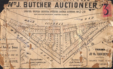 Ringwood and District Historical Society
Poster - Land Sale, Wm J. Butcher, Auctioneer - Albert Park Estate, Ringwood - c.1890
Central section of land sale subdivision advertisement glued to heavy cardboard backing. Photocopied SLV image of original advertisement shows map of 117 allotments for sale in Main Lilydale Road (later Old Lilydale Road), Wandin Road (later Mount Dandenong Road), Joseph Street, Dynes Street, Albert Street (later Wyrunga Street) and Government Road (later Carcoola Road), Ringwood East.Solicitors - Jenningw & Wright, Queen Street. Surveyors - J.&H. Tarrant, Elizabeth Street. Terms £2 10s cash deposit, balance three years at six per cent. -
 Bacchus Marsh & District Historical Society
Map, Plan of the property of Messers Atkins and Clarke to be sold at the Mansion, Bacchus Marsh 19th April 1856. Copy 1
This plan of land allotments for sale indicates the property once owned by the Bacchus family in and around the township area of Bacchus Marsh. The Bacchus family sold their property in Bacchus Marsh to John Atkins and Robert Nalder Clarke in March 1851. Atkins and Clarke kept the property for a number of years until April 1856 when these allotments were put up for sale.This plan is almost identical to another copy held by the Bacchus Marsh and District Historical Society, VC Record 452, BMDHS collection). This plan, VC Record 707 Copy 1, contains a little more detail overall than VC Record 452 Copy 2, such as who did the survey work for the plan (R.C. Bagot) and who the selling agents were, (W.M. Tennent), and on the right side of the plan near the Lerderderg River is indicated the general area for a second parcel of land from this sale which is to be sold. There is also a compass illustration indicating north and south compass points.This is a very early land sales plan for the township of Bacchus Marsh and it therefore provides some clues as to how the early urban development of the township took place. Upon seeing the map in 1911 Bacchus Marsh Express newspaper editor Christopher Crisp wrote "The sale appears to have created the present township, which had a nucleus in earlier times further east", Express, 30 September, 1911, page 3.A single page paper plan showing allotments of land for sale. The subdivided land shown was owned by John Atkins and Robert Nalder Clarke, but previously owned by the Bacchus Family and was in and around their Manor House (Mansion) property in Bacchus Marsh.There are 5 portions of land further divided into numerous small portions. The land for sale is bounded by the present day streets of Main Street, Young Street, McFarland Street, Morton Streets, Crook Street, and part of the eastern section extends to the Lerderderg River. Scale: 8 chains to 1 inch The plan is pasted into a bound volume containing 76 maps or plans in total. BMDHS Loc: AR/B12/S4 Bacchus Marsh Township and Nearby Districts Maps Volume In-house Digital copies: BMDHS, Computer Network: Maps\Bacchus Marsh Township and Nearby Districts Maps VolumeHeading: Plan of the first portion of land. The property of Messers Atkins and Clarke situate at Bacchus Marsh. To be sold by W.M. Tennent & Co. at the Mansion on the Ground on Saturday the 19th April 1856. Below heading: Jas Ferguson, Lithographer On upper right side: Subdivided by R.C. Bagot London and Liverpool Chambers, Melbourne. 'Thos Taubman'. Post Office Stamp: BACCHUS MARSH VICTORIA MY 6, 63bacchus marsh victoria maps, bacchus family, land sales, manor house bacchus marsh -
 Ringwood and District Historical Society
Document - Research Notes, Richard Carter, Land Subdivisions in Ringwood 1890-1950
Handwritten table listing main local pre-1950s subdivisions in the Ringwood area, with estate names, streets, number of allotments for sale, and where known, vendor agent, LP (Lodged Plan) title registration number, and auction/sale date, some with sale price.Pg1 RINGWOOD STATION ESTATE LP3070 (Year?) Station Street, William Street (now Kendall Street), Wantirna Road, Station Street Pg1 RINGWOOD TOWNSHIP ESTATE LP5577 (1913) Station Road (now Warrandyte Road), Pratt Street (part now Aird Street), Whitehorse Road Pg2 RINGWOOD ORCHARD ESTATE LP4315 (1914) Brysons Road, Hillcrest Road, Anzac Avenue, Sulva Road Pg3 RINGWOOD RAILWAY ESTATE LP7522 (1918) Whitehorse Road (now Mount Dandenong Road), Dublin Road, Freeman Street, Patterson Street, Bona Street Pg4 THE RINGWOOD ESTATE LP7578 (1919) Warrandyte Road, Hobart Street, Paxton Street, Arnold Street Pg5 GARDEN FARMS ESTATE (LP?) (1919) Canterbury Road, Armstrong Road, Bungalook Road, Orchard Road, Bayswater Road (now Mountain Highway) Pg6 THE RINGWOOD ESTATE (SECOND SUB-DIVISION) LP7604 (1919) Warrandyte Road, Tamar Street, Derwent Street, Mersey Street Pg7 RINGWOOD STATION ESTATE LP7703 (1919) Bedford Road, Williams Grove (now Lena Grove) Pg8 RINGWOOD TOWNSHIP ESTATE LP8198 (1919) Wantirna Road, Ellison Street, Haig Street, Greenwood Avenue Pg9 EASTFIELD ESTATE (LP?) (1920) Eastfield Road, Longview Road, Pleasant Rise, The Mount Pg10 ELECTRIC RAILWAY ESTATE RINGWOOD LP9473 (1922) Campbell Street, Myrtle Avenue, George Street (now Tudor Court), Henry Street (now Myrtle Avenue), Williams Grove (now Lena Grove) Pg11 RINGWOOD PARK ESTATE LP7884 (1922 - two stages) Wonga Road (now Loughnan Road), William Street, Andrew Street, Harrison Street Pg12 HEATHMONT STATION ESTATE LP11009 (Date? - after 1922) Lisgoold Street, Viviani Crescent, Balrour Avenue, Station Street (now part Heathmont Road and part Wainui Street) Pg13 RINGWOOD RAILWAY ESTATE LP10507 (1923) Whitehorse Road, Sherbrooke Avenue, Burwood Avenue, Bonview Avenue, Heatherbrae Avenue, Grant Crescent Pg14 GARDEN HOMES ESTATE (LP?) (1923) Mullum Road, The Centreway, Wattle Crescent (now Wattle Avenue) Reserve Crescent (now Reserve Road) Pg15 DUBLIN ROAD ESTATE LP11993 (1923) Alexandra Road, Vonadawn Avenue, Green Street, Wood Street, Howard Avenue, Bedford Road, Dublin Road Pg16 CARLINGA ESTATE RINGWOOD LP9620 (1923) Bourke Street, Bond Street, Ringwood Street Pg17 PRATT'S JUNCTION ESTATE (LP?) (1923) Junction Street, Georges Road, Oliver Street, Whitehorse Road Pg18 EAST RINGWOOD ESTATE LP10492 (1923) Bona Street, Patterson Street, Miller Grove, Fairview Avenue, Eastfield Road, Whitehorse Road (now Mount Dandenong Road) Pg19 COLEMAN'S HEATHMONT ESTATE LP9974 (1923) Canterbury Road, Bedford Road, Alvena Crescent, Coleman Street, Leonard Street (now Royal Avenue) Pg20 RINGWOOD HEIGHTS ESTATE LP10506 (1924) Whitehorse Road, Bonview Avenue, Grant Crescent, Hillcrest Avenue, Heatherbrae Avenue, Margaret Street, Mary Street Pg21 EAST RINGWOOD STATION ESTATE LP10551 (1924) Knaith Road, Wenwood Street, Lois Street, Victoria Street, Station Street (now Railway Avenue) Pg22 GRAND VIEW ESTATE LP11019 (1924) Whitehorse Road, Rupert Street, Herbert Street, Leonard Street Pg23 RINGWOOD RAILWAY ESTATE & RINGWOOD HEIGHTS ESTATE - FINAL SECTIONS LP10506 & LP10507 (1924) Whitehorse Road, Sherbrooke Avenue, Burwood Avenue, Bonview Avenue, Heatherbrae Avenue, Margaret Street, Mary Street, Grant Crescent Pg24 RINGWOOD EAST ELECTRIC STATION ESTATE (LP?) (1924) Railway Parade (now Patterrson Street), Federal Road, Howship Avenue (part now French Street), Dublin Road, Rosedale Crescent Pg25 BEDFORD PARK (now Ringwood Secondary College) (LP?) (1924) Bedford Road, Adams Street, Anderson Street, Joyce Street, Graham Road Pg26 CROWN JEWEL ESTATE LP11645 (Private sales after 1924) Mount Dandenong Road, Mirabel Avenue, Valda Avenue, Evon Avenue, Velma Grove Pg27 GRAND CENTRAL ESTATE LP10917 (1925) Heathmont Road, Great Ryrie Street, Douglas Street, Garden Street, Bellevue Avenue Pg28 RINGWOOD (unnamed estate - 1926) Nelson Street, Seymour Street, Whitehorse Road Pg29 EAST RINGWOOD RAILWAY STATION ESTATE (YEAR? - 25 shops 60 villas) Railway Avenue, Dublin Road, Lawrence Grove, Stanley Avenue, Knaith Road Pg30 CHARM VIEW ESTATE (LP?) (year? - after 1926) Canterbury Road, Heathmont Road, Dickasons Road, Bennjett Avenue, Orchid Street Pg31 SUNBEAM ESTATE LP12150 (Circa 1925) Govt Road (now Old Lilydale Road), Sunbeam Avenue, Holland Road, Everard Street (now Everard Road) Pg32 FAIRVIEW ESTATE EAST RINGWOOD LP10853 (Circa 1924) Eastfield Road, Patterson Street, Margaret Street (now Short Street) Pg33 EAST RINGWOOD TOWNSHIP ESTATE LP3025 (Circa 1924 - 35 allotments) Mount Dandenong Road, Grey Street, Eastfield Road Pg34 EAST RINGWOOD TOWNSHIP ESTATE LP3025 (Circa 1924 - 49 allotments) and STATE SCHOOL ESTATE (26 allotments) and EAST RINGWOOD STATION ESTATE (14 shop sites) Mount Dandenong Road, Grety Street, Dunn Street, Eastfield Road, King Street, Holland Road, Dublin Road, Patterson Street, Bona Street Pg35 EAST RINGWOOD CENTRAL ESTATE LP17004 (1948) Knaith Road, Shasta Avenue, Talofa Avenue, Russet Road, Dublin Road Pg36 WARE ESTATE LP43360 (1958) Ware Crescent, Davey Drive, Grey Road (now Grey Street), Mount Dandenong Road Pg37 Lot 57 Kendall Street LP3070 (1939) £75.0.0 Pg37 Lot 14 LP7346 (year?) £225 Pg37 Lot 8 WHITE HORSE ESTATE LP14010 (year?) Maroondah Hwy, Seymour Street £98.9.0 Pg37 Lots 4-14 incl. LP10902 (year?) £300 Pg37 Lots 69&70 LP2216 (1939) Bedford Road, Pitt Street £500 Pg37 Lots 60&70 LP2216 (year?) £460 Pg37 MOUNTAIN VIEW ESTATE LP10902 (1936) Lots 1&2, 19-22 Wantirna Road, Daisy Street £50 Pg38 RAILWAY STATION ESTATE RINGWOOD EAST LP7522 (1925) Lots 16 to 19 £250 Pg38 RINGWOOD PARK ESTATE (LP?) (1924) Lot 112 Munro Street £230 Pg38 RINGWOOD TOWNSHIP ESTATE (LP?) (1925) Lot 57 Wantirna Road £850 Pg38 ELECTRIC RAILWAY ESTATE LP9473 (1925) Lot 98 & 99 £180 (30/- foot) Pg38 ELECTRIC RAILWAY ESTATE LP9473 (year?) Lot 100 £233.12.6 incl improvements (£2.12.6 foot) Pg38 Lot 22&23 Bedford Road Heathmont (LP & year?) £675 incl improvements Pg39 Lot 9 Mullum Mullum Road LP8221 (1923) £150 Pg39 Lot 27 Haig Street LP8198 (1925) £825 Pg39 Lot 56 Haig Street cnr Wantirna Road LP8198 (1923) £171 Pg39 Lots 3 & 4 Loughnan Road LP9626 (192?) £147 Pg39 Lots 98 & 99 Myrtle Avenue LP9473 (1925) £180 Pg39 Lots 80 & 81 Myrtle Avenue LP9473 (1929) £150 Pg39 Lot 30 Sherbrooke Avenue LP10507 (1926) £700 incl improvements Pg40 Lot 10 (year?) LP7703 £750 Pg40 Lot 36 (year?) LP7522 £25 Pg40 Lot 38 Pitt Street LP2216 (year?) £350 Pg40 Lot 7 Dublin Road cnr Green Street LP11993 (year?) £300 -
 Eltham District Historical Society Inc
Document - Property Binder, 616 Main Road, Eltham; Plum Cottage
Plum Cottage is covered by Heritage Overelay HO256 in the Nillumbuk Planning Scheme This two-lot land holding was created as a subdivision and sold to Charles Stuart McNeil by May 1955. Sometime in the period 1955-1960, the builder-designer, John Harcourt had created a pise house on the site, straddling the two subdivision lots. The designer, John M. Harcourt was a pioneer builder in pise-de-terre and mudbrick in the Eltham Shire, Eltham being synonymous with alternative lifestyles and building practises until the onset of suburbia in the late 20th and early 21st centuries. This hipped-roof house is set high above Main Road on a V-shape plan characteristic of the Arts & Crafts style, with rammed earth or pise walls, timber joinery and a cement tiled roof. The V shape plan was used by important English and Eltham Arts & Crafts designers. The use of natural materials such as stone and timber construction is an essential part of the Arts & Crafts style and Harcourt’s work. So too is the application of the style on both the exterior and interior of the house as a holistic concept. The house adjoins the Lim Joon adobe house built and designed by Alistair Knox in the same era (HO119), thus forming a distinctive pair, both using an uncommon plan form. This house was identified in the Shire of Shire of Eltham Heritage 1992 as contributory to the Eltham Gateway Conservation Area, then proposed as an urban conservation area (now Heritage Overlay Area). Land Ownership Emily Jane Smith of 12 Woodside Street Fitzroy owned Crown Allotments 1 & 2 Sections 14, 27 by August 1918, selling to William Henry Smith of 12 Woodside Street, Nth Fitzroy May 1921. (John) James Isherwood of Main Road, Eltham owned the property by 1928 (the year of his death) with the beneficiary of his estate and next owner of this site being his widow, Minnie Maria Isherwood of Cemetery Road, Eltham. His holding in Main Road included parts of what was described in rate records as allotments1 & 2 Section E6. In the late 1930s, early 1940s her son Alfred John Isherwood was also rated for the land around this site, with the rated nett annual value varying between £2 and £5. Alfred Isherwood also lived at Main Road, Eltham with his wife Ellen: her early death at the age of 24 was reported in the Argus of 1923. Part of the Isherwood land was divided off and sold to Charles Stuart McNeil by May1955. Sometime in the period 1955-1960, the builder-designer, John Harcourt had created a pise house on the site, straddling the two subdivision lots. The house is visible on an aerial photograph from 1960s. Reputedly the house was called Plum Cottage and erected for Harcourt’s mother-in-law. A garage was added in 1959. Charles McNeil died in1971 aged 87: he was the son of Don McNeil and Margaret Arkell. Available rate records from the construction era start in the of the 1970s (1972-3) and list Mr H.C. & M/S A.V. Charity at 616 Main Road Eltham of this property with a nett annual value of $740. More recent valuer's data describes the property as lots 1 & 2 LP25668, located in the Central Riding of Eltham Shire, owned by Ann Valerie Charity and later, in 1990, by the Chincarini family. Building Description This hipped roof 11 .5 square house is set high above Main Road on a characteristic-shape plan and has rammed earth or pise walls, timber joinery and a cement tiled roof. The V-shape plan was used by Important designers such as C.F.A. Voysey (UK) who interpreted medieval domestic architecture as part of the Arts & Crafts style of the late 19th and early 20th centuries. The pise walls are covered with a textured render while the cement roofing tiles are also seen in the Harcourt Hill examples. Reputedly the ceiling joists are of a deep section and span long lengths with no need for hanging beams in the roof space. The ceilings are low and panelled in main rooms with apparently Caneite soft board infill panels between the exposed ceiling beams. These are painted white but may have been stained at one time. The focus of the house is the large living area with its vast random stone fireplace. Significance Plum Cottage is significant to the locality of Eltham because: Historically: • Plum Cottage is closely associated with the important historical theme of earth construction evident in Eltham and elsewhere in the Shire since theear1y Arts & Crafts inspired creations at Penleigh Boyd's The Robins (1912, HO101) and those at Montsalvat (1934-, HO82) but more prominent from the Second War period when earth building in Eltham was promoted in national periodicals as an alternative building method that avoided the building materials shortages of that era; • The choice of the earth building technique also expresses the theme of refuge or alternative living, synonymous with Eltham in the early to mid 20th century; • as a good example of domestic architecture from John Harcourt who was the first major post Second War figure in an important phase of Eltham’s earth building development, using his characteristic Old English or Arts& Crafts style that relies in this case on the pise wall construction, pitched roof forms, exposed ceiling joists, half timbering, random stonework, and panelled internal wall finishes. Architecturally: • Plum Cottage's pise wall construction is uncommon among the early earth-walled structures in the Shire, that are mainly of adobe or mud brick, and as a building material is uncommon among the Shire’s suburban dwellings generally which are clad typically with either fired clay bricks or timber boarding. Aesthetically: • Plum Cottage is a good and well preserved example of a modern Old English or Arts & Crafts style earth-walled building in the Shire • For the proximity of the significant Lim Joon adobe house designed by Alistair Knox adjoining to the north, providing a distinctive earth wall house pair, with uncommon plan forms. Reference Heritage Assessment of Plum Cottage, 616 Main Road, Eltham; Graeme Butler & Associates 2010main road, eltham, property, houses, (john) james isherwood, alfred john isherwood, ann valerie charity, arts and crafts style, charles stuart mcneil, chincarini family, eltham gateway zone, emily jane smith, h.c. charity, heritage assessment, john harcourt, john m. harcourt, lim joon house, main road eltham, minnie maria isherwood, pise construction, plum cottage