Showing 42 items
matching map of castlemaine
-
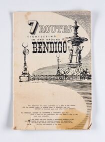 City of Greater Bendigo - Civic Collection
Booklet, J. W. H Publications, 7 Routes. Sightseeing in and around Bendigo, c 1950
A publication promoting visitation and automobile touring around Bendigo and surrounding districts. Suggests seven routes and contains extensive advertising for accommodation, businesses and services within Bendigo and Castlemaine.Thirty two page tourist fold out booklet containing maps and directions for half day and day routes in the district. Booklet also contains advertising promoting Bendigo and District businesses. city of greater bendigo commerce, city of greater bendigo tourism, making a nation exhibition -
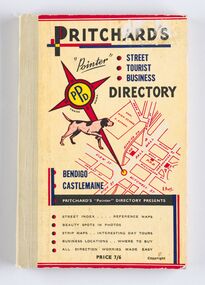 City of Greater Bendigo - Civic Collection
Book - Street Directory, A. E. Pritchard, Pritchards 'Pointer' Street - Tourist - Business - Directory, 1953
As tourism and car culture grew in the early and mid 20th century the need for street and touring directories grew. Bendigo's geographic location within central Victoria and relatively closeness to Melbourne meant that the district has long been an ideal car touring destination. A. E. Pritchard was a licensed surveyor with an office in Bull Street Bendigo and produced these handy bound directories which fit neatly into the car glovebox therefor serving both the local and state demand for high quality printed directories such as these. One hundred and thirty page printed and bound street and touring directory. Includes fold out reference and day touring maps, photographs of local 'beauty' spots and extensive advertising by local businesses. Heavy card used for front and back covers. Three colour print process.Pritchards 'Pointer' Directory Bendigo - Castlemaine.city of greater bendigo commerce, city of greater bendigo tourism, city of greater bendigo leisure, making a nation exhibition, cambridge press, mayor w cambridge -
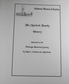 Wodonga & District Historical Society Inc
Book - The Mortlock Family History 1833-2003, R. Polkinghorne & R Mortlock
A detailed history of the Mortlock family, from their convict and then successful settler ancestor, Thomas John Mortlock, through succeeding generations of high-country settlers. Later branches of the family settled in the Castlemaine area, Wagga Wagga and Bethanga near Wodonga, Victoria. The history is profusely illustrated with maps, family photographs provided by Maud Cadman. There is some detail of the methods of settling the high country of the Monaro before the new Land Acts of 1861 and anecdotal reference to one family member running the Post Office at the Prisoner of War Camp at Cowra during World War IInon-fictionA detailed history of the Mortlock family, from their convict and then successful settler ancestor, Thomas John Mortlock, through succeeding generations of high-country settlers. Later branches of the family settled in the Castlemaine area, Wagga Wagga and Bethanga near Wodonga, Victoria. The history is profusely illustrated with maps, family photographs provided by Maud Cadman. There is some detail of the methods of settling the high country of the Monaro before the new Land Acts of 1861 and anecdotal reference to one family member running the Post Office at the Prisoner of War Camp at Cowra during World War IImortlock family, high country, bethanga, thomas mortlock, monaro -
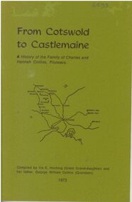 Bendigo Historical Society Inc.
Booklet - From Cotswold to Castlemaine
A history of the Family of Charles and Hannah Collins, Pioneers. 24-page booklet. Compiled in 1973 by Iris E. Hocking (Great Granddaughter) and her father, George William Collins (Grandson). Sketch map of Victorian Goldfields area on title page. B&W photos of George C R Collins and Jemima on page 13. B&W photo of family of George and Jemima on page 14. Printed by Advertiser (Jamieson) Printery.Signature of Iris E. Hocking in ink at bottom of page 1.charles and hannah collins, family history, george c r collins, hannah charlotte whitaker-clarke, jemima martin, charles collins, hannah collins -
 Bendigo Historical Society Inc.
Map - SECTIONS ACROSS BENDIGO GOLDFIELD
Map in three sections showing sections across Bendigo Gold Field, showing anticlines, synclines, faults, stratigraphical zones and mines along the reef lines. Key shows rock types Castlemaine, Bendigo B1, B2, B3 and B4, and Lancefieldian. First part of map shows sections A-A, B-B and C-C. Reef lines drawn with mines listed: Fault line shown are the Carshalton, Stafford, New Chum, Virginia and Clarence. A datum line shows 600 ft above sea level. On bottom of plan: ' Prepared in the Geological Survey Office, Bendigo, under the direction of H. Herman, late Director of Geological Survey, from surveys by H.S. Whitelaw, Field Geologist, assisted by E.S. Usher, A.J.J. Moore and R.A. Keble.' Second section of map shows sections D-D, and E-E. Fault lines listed are the Tambour Major fault, Carshalton fault, Stafford fault, Nell Gwynne fault, New Chum fault, Deborah fault. Third section shows sections F-F and G-G. Fault lines listed are the Bird Reef fault, Kangaroo Gully fault, Langdon fault, Carshalton fault, Nell Gwynne fault, Spring Gully fault, Hustlers fault, Gravel Hill fault, Ordes fault, Thanet fault. This map forms part of the Geological Survey of Victoria, Structure of Bendigo Goldfield report, No. 47, 1923. H.Herman, late Director of Geological Survey.Geological Survey of Victoriabendigo, gold mining, reef line maps -
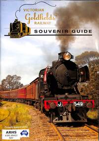 Victorian Railway History Library
Naylor, Andrew, Victorian Goldfields Railway Souvenir Guide, 2017
A souvenir guide book for the Victorian Goldfields Railway from Castlemaine to Maldon in Victoria.ill, maps, p.47.non-fictionA souvenir guide book for the Victorian Goldfields Railway from Castlemaine to Maldon in Victoria.preserved locomotives - victoria - history, tourist railways and museums - victoria -
Lakes Entrance Historical Society
Book, Government Printer, Reports of the Mining Registrars for the quarter ended 31st December 1887, 1887
Reports of the Mining Registrars for Mining Districts of Ballarat Beechworth Sandhurst Maryborough castlemaine Ararat and Gippsland to 31st December 1887 Geological details mine plans and maps are included.mines and mining, government, geographic -
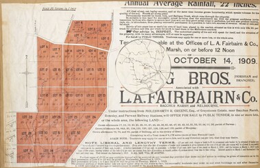 Bacchus Marsh & District Historical Society
Map, Greystones Estate Land Sale 1909
... A single page paper map showing portions of land for sale... to Melbourne, Geelong, Ballarat and Castlemaine. The top of the map ...This map was produced sometime around mid 1909 to advertise portions of land from the Greystones Estate for sale by public tender. The selling agents were Young Brothers of Horsham and L.A. Fairbairn of Bacchus Marsh and Melbourne. The seller was Molesworth R. Greene who was a pioneer pastoralist in the Bacchus Marsh area and had also acquired other properties in Victoria and interstate. Molesworth Greene died in 1916 so this sale came towards the end of his life. A total of 4,176 acres was offered for sale in multiple lots. Successful tenderers could buy single or multiple lots. The results of the sale were reported in the Bacchus Marsh Express newspaper on the 16th October 1909, page 3. At the sale a total of 3, 420 acres was sold. A single page paper map showing portions of land for sale from the Greystones Estate near Bacchus Marsh. The map includes extensive details about the property, number of allotments for sale, terms and conditions of the sale and prices. The map includes an inserted reference map showing the location of the property in relation to Melbourne, Geelong, Ballarat and Castlemaine. The top of the map appears to be missing resulting in some loss of the text. The sale notice in the Bacchus Marsh Express of 10 July, 1909, page 3, column 1 appears to duplicate the text overall in the auction plan. Based on this the missing text is likely to be: "Important Subdivisional Sale 'Of Portion of One of the Best and Most Favourably known Estates IN THE RENOWNED BACCHUS MARSH DISTRICT. And situated only six miles from that prosperous township, two miles from Rowsley, and three miles from Parwan, all Railway towns, connected with the Estate by metal roads." Scale: 20 chains to 1 inch The map is pasted into a bound volume containing 76 maps or plans in total. bacchus marsh victoria maps, land sales, land sales bacchus marsh, greystones estate bacchus marsh, molesworth r. green 1827-1916, land sales rowsley -
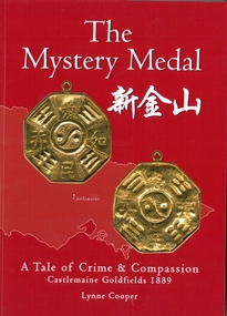 Bendigo Historical Society Inc.
Book - The Mystery Medal. A Tale of Crime and Compassion. Castlemaine Goldfields 1889, Lynne Cooper, 2024
Biography of Henry William Frood who served 32 years as a member of the Victorian Police Force. Written by his great granddaughter Lynne Cooper. Soft cover book. Red soft cover with images of two sides of a gold coloured medal. map of Victoria outline in background. Illustrated with black and white and coloured photographs. 98 pp. Hand written on the Dedication page in gold coloured texta "Lynne Cooper Bendigo 2024 Available from: Goldfields Library & The Golden dragon Museum".henry william frood, chinese, medals -
 Bendigo Military Museum
Map - TRENCH MAP, FRANCE WW1, FRAMED
... rear: The Union Studio - Castlemaine sticker. Trench map ...Belonged to JOHN WILLIAM GRINTON No 1043 C Coy 38th Batt AIF. Refer Reg No 1280 for Service Details also 1317P, 1319P. Refer 1634P for the story on the map.Trench map of France - Edition 5A Bellicourt - Montbrahain - Bran Court. Tan, wooden frame, glass front with white cardboard backing. Hanging wire attached at back with centre strengthening brace. Map stuck on white background. German trenches in blue. Top middle: France. RHS bottom rear: The Union Studio - Castlemaine sticker.documents - maps, frame accessories, military history - army -
 Bendigo Historical Society Inc.
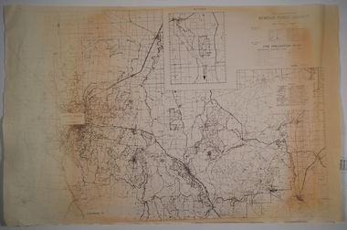
Map - CAMPBELL COLLECTION: BENDIGO AND DISTRICT MAPS
... Area, Castlemaine F.D. Map CAMPBELL COLLECTION: BENDIGO ...Map. Forest Commission Victoria, Bendigo Forest District, Basic information prepared 1982, scale 1:100,000. Fire Prevention Strategy Plan. Mitiamo, Greater Bendigo Area, Castlemaine F.D.map, bendigo, forest district -
 Bendigo Historical Society Inc.
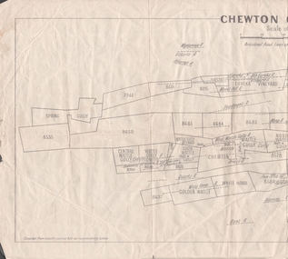
Map - MINING REPORTS - PLAN OF CHEWTON GOLDFIELD 1937
Plan of the Chewton Goldfield with Scale Measurement in chains. Plan shows the township of Chewton with the reefs and leases, the railway line and the Main Castlemaine - Melbourne Road. Also, the Eureka Vineyard. Issued by The Stock Exchange of Melbourne, April 1937. Leases named are: Central Wattle Gully, Wattle Gully United, Wattle Gully Extended, South Wattle Gully, Golden Wattle, Chewton, White Horse, Wattle Gully, North Wattle Gully, North Chewton, Upper Barkly, Post Office Hill, Misima United, Argus Hill, Chapmans, Chewton Prospecting Co, Fiji Gold & Gold Mines of Fiji and Nimrod. Stamp in the top right corner: Edward Dyason & Co. - Queen St. Melbourne. Sharebrokers.map, mining reports, plan of chewton goldfield, edward dyason & co, the stock exchange of melbourne, central wattle gully, wattle gully united, wattle gully extended, south wattle gully, golden wattle, chewton, white horse, wattle gully, north wattle gully, north chewton, upper barkly, post office hill, misima united, argus hill, chapmans, chewton prospecting co, fiji gold & gold mines of fiji, nimrod