Showing 518 items
matching map of mine
-
 Bendigo Historical Society Inc.
Document - FOSTERVILLE GOLD MINE COLLECTION: OPEN DAY 2018
... , and a map of the mine site showing location of various displays.... to visitors on the 2018 Open Day, and a map of the mine site showing ...2 page document, coloured, titled 'Kirkland Lake Gold' and 'Welcome to the Fosterville Gold Mine Open Day 2018'. Document describes activities available to visitors on the 2018 Open Day, and a map of the mine site showing location of various displays.bendigo, mining, fosterville gold mine -
 Bendigo Historical Society Inc.
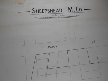
Administrative record - Sheepshead M. Co
... Draftsman's drawing Sheepshead Mine Map. Forms part...Bendigo Margaret Roberts gold Map Mine Sheepshead M.Co ...Draftsman's drawing Sheepshead Mine Map. Forms part of the Margaret Roberts Collection of mining records.bendigo, margaret roberts, gold, map, mine, sheepshead m.co -
 Bendigo Historical Society Inc.
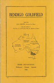
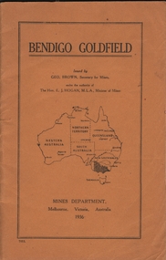
Book - 'BENDIGO GOLDFIELD', 1936
... . Underneath the Map is printed 'Mines Department, Melbourne, Victoria... by Mines Department Victoria Yellow cover with a map of Australia ...Bendigo Goldfield. Produced by Mines Department Victoria Yellow cover with a map of Australia depicting the states and highlighting Victoria. Issued by Geo Brown Secretary of Mines. Underneath the Map is printed 'Mines Department, Melbourne, Victoria, Australia 1936. Maps at the back of book.Mines Department Victoriabendigo, mining, early history., bendigo - history, mining, and bendigo goldmines. -
 Coal Creek Community Park & Museum
Mine Map
... Mine Map...6295.1 - Large map of Korumburra coal mine; shows seams... Korumburra gippsland 6295.1 - Large map of Korumburra coal mine ...6295.1 - Large map of Korumburra coal mine; shows seams, tunnels, railways, roads and Leura Creek. There is a grid over the main area and a scale legend. -
 Federation University Historical Collection
Booklet - Exercise Book, Sebastopol Mines and Socialism
... .1) Black notebook with red spine .2) hand drawn map...) hand drawn map showing location of Sebastopol mines Sebastopol ...Sebastopol is a suburb of Ballarat..1) Black notebook with red spine .2) hand drawn map showing location of Sebastopol minesHandwritten pageswilliam robertson, new lady don company, kohinor company, leviathon company, newington, copenhagen company, hand in hand company, tannery ground, ballarat freehold company, rough and ready company, park company, inkerman alluvial lead, band & albion consols, gravel pits lead, robert gay, sebastopol mines, ballarat east, alluvial, dalton's flat, canadian gully, red streak, montezuma company, great republic company, golden point, gravel pits, j. hardy, scott's boot shop, lady don company, cgt -
 Bendigo Historical Society Inc.
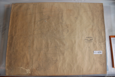
Administrative record - Mine Map
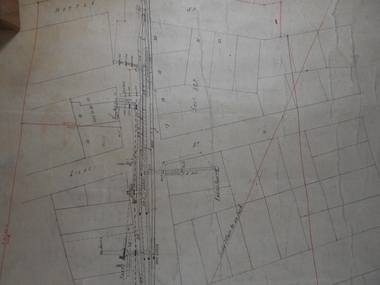
... Mine Map...Draftsman's drawing Mine Map. Additional pencil markings...Bendigo Margaret Roberts gold Map Mine Draftsman's drawing ...Draftsman's drawing Mine Map. Additional pencil markings. Forms part of the Margaret Roberts Collection of mining records.bendigo, margaret roberts, gold, map, mine -
 Bendigo Historical Society Inc.
Administrative record - St Mungo Co
... Draftsman's drawing St Mungo Co Mine Map. Forms part...Bendigo Margaret Roberts gold Map Mine St Mungo Co ...Draftsman's drawing St Mungo Co Mine Map. Forms part of the Margaret Roberts Collection of mining records.bendigo, margaret roberts, gold, map, mine, st mungo co -
 Bendigo Historical Society Inc.
Administrative record - Central Blue Section
... Draftsman's drawing Central Blue Section Mine Map. Forms...Bendigo Margaret Roberts gold Map Mine Central Blue Section ...Draftsman's drawing Central Blue Section Mine Map. Forms part of the Margaret Roberts Collection of mining records.bendigo, margaret roberts, gold, map, mine, central blue section -
 Bendigo Historical Society Inc.
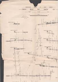
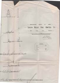
Map - STRUGNELL COLLECTION: UNDERGROUND SURVEY OF MINES BENDIGO, 25/05/01
... Map, Underground Survey of Mines, Bendigo, South Belle Vue...MAP Bendigo belle vue united coy A.S.Whitelaw Map ...Map, Underground Survey of Mines, Bendigo, South Belle Vue United Coy, New Chum Line, Surveyed under the Supervision of H.Herman,B.C.E.,F.G.S.,Acting Government Geologist.A.S.Whitelawmap, bendigo, belle vue united coy -
 Bendigo Historical Society Inc.
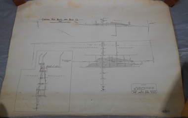
Administrative record - Central Red White and Blue Mine
... Draftsman's drawing Central Red, White, and Blue Mine Map...Bendigo Margaret Roberts gold Map Mine Central Red White ...Draftsman's drawing Central Red, White, and Blue Mine Map. Forms part of the Margaret Roberts Collection of mining records.bendigo, margaret roberts, gold, map, mine, central red white and blue -
 Bendigo Historical Society Inc.
Administrative record - Sheepshead or Red White and Blue Mine
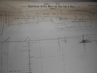
... Draftsman's drawing Sheepshead or Red White and Blue Mine...Bendigo Margaret Roberts gold Map Mine Sheepshead or Red ...Draftsman's drawing Sheepshead or Red White and Blue Mine Map. Forms part of the Margaret Roberts Collection of mining records. Notes in pencil bendigo, margaret roberts, gold, map, mine, sheepshead or red white and blue reef -
 Bendigo Historical Society Inc.
Administrative record - North Red White and Blue and Sheepshead Mine
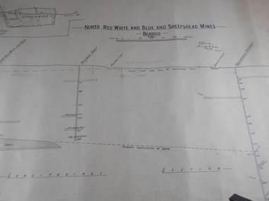
... and Sheepshead Mine Map. Forms part of the Margaret Roberts Collection...Bendigo Margaret Roberts gold Map Mine North Red White Blue ...Draftsman's drawing Central Red, White, and Blue and Sheepshead Mine Map. Forms part of the Margaret Roberts Collection of mining records.Handwritten on plan, Warden's Camp Bendigo Exhibit, Apportion for Forfeiture 8.8.10 (1910) Notes in pencil of measurementsbendigo, margaret roberts, gold, map, mine, north red white blue and sheepshead -
 Bendigo Historical Society Inc.
Administrative record - Lansell's Concord Mine Map
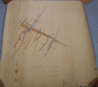
... Lansell's Concord Mine Map...Draftsman's drawing Lansells Concord Mine Map. Additional...Bendigo Margaret Roberts gold Map Mine Lansell's Concord ...Draftsman's drawing Lansells Concord Mine Map. Additional pencil markings for legend Forms part of the Margaret Roberts Collection of mining records.bendigo, margaret roberts, gold, map, mine, lansell's concord -
 Bendigo Historical Society Inc.
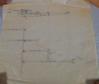
Map - STRUGNELL COLLECTION: UNDERGROUND SURVEY OF MINES, BENDIGO, 29-3-01
... Map, Underground Survey of Mines, Bendigo, South Belle Vue... Inc. History House 11 Mackenzie Street Bendigo goldfields MAP ...Map, Underground Survey of Mines, Bendigo, South Belle Vue United Co.,New Chum Line.Transverse Section. Signed H.S.Whitelaw29.3.01 Drawing appears to show samples of connecting horizontal shafts with their respective mineral contentsH.S.Whitelawmap, bendigo, south belle vue united co.. -
 Coal Creek Community Park & Museum
Mine Map, 1933
... Mine Map...6299.1 - Very faded map of Outtrim coal mine area detailing... Korumburra gippsland 6299.1 - Very faded map of Outtrim coal mine ...6299.1 - Very faded map of Outtrim coal mine area detailing mine tunnels, tramways, topography and other information. Shows later small addendum/modification in ball point pen, Done 26/06/1953 -
 Bendigo Historical Society Inc.
Map - MAP: VIRGINIA MINE GARDEN GULLY LINE OF REEF
... MAP: VIRGINIA MINE GARDEN GULLY LINE OF REEF...Map of Virginia Mine on the Garden Gully line of reef... Victoria, Geological Survey Office, Bendigo. Map of Virginia Mine ...Map of Virginia Mine on the Garden Gully line of reef, Eaglehawk, transverse section. Shaft, levels and Garden Gully anticlinal axial line drawn. Key shows types of formations - quartz, spurs, sandstone, slate, cleavage, lava. This map forms part of the Geological Survey of Victoria, Structure of Bendigo Goldfield report, No. 47, 1923. H.Herman, late Director of Geological Survey.Geological Survey Victoria, Geological Survey Office, Bendigo.bendigo, gold mining, virgina mine eaglehawk, eaglehawk, bendigo, gold mining, virginia mine, garden gully line of reef. -
 Bendigo Historical Society Inc.
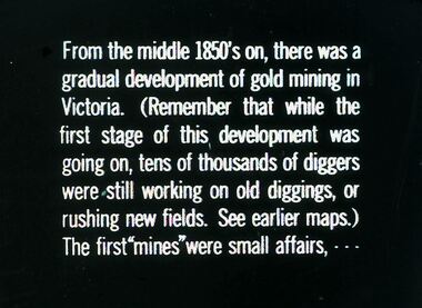
Slide - DIGGERS & MINING. DIGGERS AND MINERS, c1850s
... diggings, or rushing new fields. See earlier maps.) The first.... See earlier maps.) The first ''mines'' were small affairs ...Diggers & Mining. Diggers and miners. From the middle 1850's on, there was a gradual development of gold mining in Victoria. (Remember that while the first stage of this, development was going on, tens of thousands of diggers were still working on old diggings, or rushing new fields. See earlier maps.) The first ''mines'' were small affairs, - - - Markings: 25 994:LIF I. Used as a teaching aid.hanimounteducation, tertiary, goldfields -
 Bendigo Historical Society Inc.
Document - GREAT EXTENDED HUSTLERS: MAPS OF HUSTLERS MINE SITE
... Three maps, copies. Great Extended Hustlers mine site... and reserve. Document GREAT EXTENDED HUSTLERS: MAPS OF HUSTLERS MINE ...Three maps, copies. Great Extended Hustlers mine site. Hustlers Royal Reserve No. 2 Mine. Streets around Great Extended Hustlers mine site and reserve.bendigo, mining, great extended hustlers -
 Bendigo Historical Society Inc.
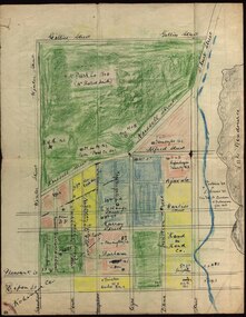
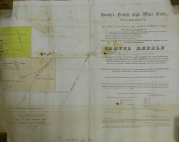
Document - MARKS COLLECTION: BOUNDY'S FREEHOLD GOLD MINES MALMSBURY
... freehold land. Document contains map of mines, names include... contains map of mines, names include O'Connors Freehold Company ...Plan/advertisement 1888 for the sale of the Boundy's Freehold Gold Mines Malmsbury, 260 acres of auriferous and arable freehold land. Document contains map of mines, names include O'Connors Freehold Company, Egyptian Company, Queen's Birthday Company, No.1 South Queen Company, Madam O'Connor's company, Extended South Queen's Birthday Company. Scale 10 chains to one inch. Taken from Mr. H. Archdale's Plan by Walter Sleeman, Mining Mgr., Oct 9th. 1888. On RH side of map Daylesford Road to Malmsbury marked. The land is only about two miles from the Malmsbury railway station. On back of document letter from Henry Nutman, Mining Manager, Queens Birthday Company; Report on Plan Walter Skleeman, M.M.; letter to S. Deeble, 35 Queen St., Melbourne with report on mine from George Jenkyn and Mining Manager's Report in Argus 24th.October 1888.mine, gold, boundy's freehold gold mine -
 Bendigo Historical Society Inc.
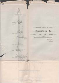
Map - STRUGNELL COLLECTION: UNDERGROUND SURVEY OF MINES BENDIGO, 27-3-01
... Map, Underground Survey of Mines, Shamrock Co., New Chum... Inc. History House 11 Mackenzie Street Bendigo goldfields MAP ...Map, Underground Survey of Mines, Shamrock Co., New Chum Line, Bendigo. Transverse Section, Garibaldi Reef, Young Chum Reef, Thorpe's Reef, Mundic Reef, Shenandoah Reef, New Chum Railway Reef, Surveyed under the Supervision of H.Herman.H.S.Whitelaw.map, bendigo, shamrock co. -
 Bendigo Historical Society Inc.
Document - UNDERGROUND SURVEY OF BENDIGO MINES
... on Constellation Company's Mine on northern extension of the Garden Gully...BENDIGO Mining garden gully line of reef mines Jems ...Two page document, 'Underground survey of Bendigo, report on Constellation Company's Mine on northern extension of the Garden Gully line of reef. Report on the New Chum Railway Reserve Company and the Shenandoah Company, the New Chum Railway Co being immediately south and the Shenandoah Co immediately north of the railway line. Two maps Constellation Co. Mine shaft and New Chum Railway and Shenandoah auriferous reef below 2700 feet.Jems Stirling, geologist and W.H Cundy Underground Surveyor, Department of Minesbendigo, mining, garden gully line of reef mines -
 Bendigo Historical Society Inc.
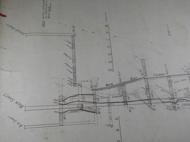
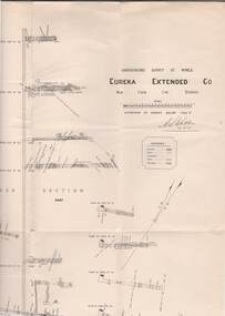
Map - STRUGNELL COLLECTION: UNDERGROUND SURVEY OF MINES, BENDIGO, 29-4-01
... Map, Underground Survey of Mines, Bendigo.Eureka Extended... Inc. History House 11 Mackenzie Street Bendigo goldfields MAP ...Map, Underground Survey of Mines, Bendigo.Eureka Extended Co., New Chum Line. Signed H.A.Whitelaw 29.4.01 Drawing shows mine shaft from 1871 feet to over 3030 feet deep and appears to show samples of connecting horizontal shafts with their respective mineral contents.A>S>Whitelawmap, bendigo, eureka extended co. -
 Bendigo Historical Society Inc.
Administrative record - Central Red, White and Blue Mine map
... Central Red, White and Blue Mine map...Draftsman's drawing of Central Red, White and Blue Mine Map...Bendigo Margaret Roberts gold Map Mine Central Red White ...Draftsman's drawing of Central Red, White and Blue Mine Map. Printed by Troedel & Cooper Pty Ltd. Mr. H. Cumby, Surveyor Forms part of the Margaret Roberts Collection of mining records.bendigo, margaret roberts, gold, map, mine, central red white & blue -
 Bendigo Historical Society Inc.
Map - STRUGNELL COLLECTION: UNDERGROUND SURVEY OF MINES BENDIGO
... Map, Underground Survey of Mines, Bendigo, New Chum Railway.... Drawing shows mine shafts to over 3100 feet deep Map STRUGNELL ...Map, Underground Survey of Mines, Bendigo, New Chum Railway Reef, Shenandoah Co's Shaft, Shamrock Co's Shaft.Young Chum Reef, Thorpe's Reef, Shenandoah Reef, Consolidated Reef, Sheet 3.Survey under the Supervision of H.Herman. Drawing shows mine shafts to over 3100 feet deepmap, bendigo, shamrock & shenandoah co's -
 Bendigo Historical Society Inc.
Map - GREAT EXTENDED HUSTLER'S MINE - PLAN OF THE GREAT EXTENDED HUSTLER'S MINE
... No 7382. Plan has map of streets. Mine was located in the block...MINING Parish Map Great Extended Hustler's Mine Hustler's ...Plan of the Great Extended Hustler's Mine on the Hustler's Line of Reefs, Bendigo. Bulletin No 33, Plate No X. Lease No 7382. Plan has map of streets. Mine was located in the block bounded by Langston and Anderson Streets and was between the Hustler's Anticline at Surface and the Lightning Hill Anticline at Surface. Latham & Watson's Shaft is also mentioned. Levels are numbered and a table shows the Levels and their Depths. Geological Survey of Victoria. Signed by H A Whitelaw, Underground Survey Office, Bendigo, September 1913. This item has not been scanned or photographed.mining, parish map, great extended hustler's mine, hustler's line of reefs, mining lease no 7382, geological survey of victoria, underground survey office bendigo, h a whitelaw, latham & watson's shaft -
 Bendigo Historical Society Inc.
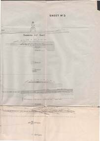
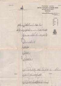
Map - STRUGNELL COLLECTION: UNITED HUSTLER'S & REDAN MINE, September 1913
... Map, United Hustler's & Redan Mine, Transverse Section... Bendigo hustler's & redan mine Underground Survey Office Map ...Map, United Hustler's & Redan Mine, Transverse Section, Hustler's Line of Reefs, Bendigo. Plate No. XX1X (29).Bulletin No 33 Signed H.A.Whitelaw. Drawing shows the vertical shaft descending to over 1805 feet and appears to show samples of connecting horizontal shafts with their respective mineral contents. One level shows respective water levels .Underground Survey Officemap, bendigo, hustler's & redan mine -
 Bendigo Historical Society Inc.
Book - BENDIGO GOLDFIELD
... and mines. Map of goldfield showing reef lines and mines attached... goldfield and major lines of reef and mines. Map of goldfield ...booklet, 51 pages. 'Bendigo Goldfield' issued by Geo Brown, Secretary for Mines. Mines Department 1936. Contains information on the geology of the Bendigo goldfield and major lines of reef and mines. Map of goldfield showing reef lines and mines attached to back cover.bendigo, mining, bendigo goldfield -
Bendigo Historical Society Inc.
Book - 'BULLETINS OF THE GEOLOGICAL SURVEY OF VICTORIA NO. 30'. THE PEARL AND HERCULES AND ENERGETIC MINES, BENDIGO, 1914
... and sections. By W. Baraganath Underground maps of the 4 (four) mines... Underground maps of the 4 (four) mines referred to in this book ...Bulletins of the Geological Survey of Victoria No. 30. The Pearl and Hercules and Energetic Mines, Bendigo, with plans and sections. By W. Baraganath Underground maps of the 4 (four) mines referred to in this book. Priced six pence Inscribed on the front cover: A. Richardson, 29 Harrison Street, Bendigo.Department of Mines. By W. Baraganathbendigo, mining, early history., mining, pearl, hercules and energetic mines. -
 Eltham District Historical Society Inc
Folder, Victorian Goldfields Project: Historic gold mining sites in St Andrews mining division, 1999
... of map headed: Location of mines and reefs from Geological survey... of map headed: Location of mines and reefs from Geological survey ...Heritage site report and gazetteer by David Bannear, head consultant for archealogy for the Department of Natural Resources and Environment. Includes information on the Warrandyte Goldfield and the Caledonia Goldfield, Queenstown (now known as St Andrews), One Tree Hill, Kingston (now known as Panton Hill), Kangaroo Grounds, You You Hill, Kingstown, South Morang, Nillumbik, (now known as Diamond Creek), Steele's Creek, Yarrambet and Kinglake. Photocopy of map headed: Location of mines and reefs from Geological survey of Victoria, Yan Yean with the Diamond Creek prominant on the map. no date35 page report with map and print out of cover letter (email form) from donorcaledonian gold fields, caledonina gold field, david bannear, gold mining, harry gilham collection, queenstown, st andrews, warrandyte goldfield -
Clunes Museum
Map, DEPARTMENT OF MINES, Untitled, c1859
... .1 Map of Creswick Clunes - lists 45 mines in the Clunes...All maps show names and locations of mines operating ...All maps show names and locations of mines operating in the district (see reference section link to article).1 Map of Creswick Clunes - lists 45 mines in the Clunes enlargement and 100 mines in the Creswick enlargement .2 Department of Mines map of Clunes Creswick and shows the McDonald & Co. Pre-emptive area. Indexes for quartz and alluvial mine locations .3 Topographical map Ref GF23 Clunes Mt. Greenock Talbot.1 360 Scale 1:2500 .2 303/59 33 hand written in ink "received 15 October 1859" signed by R Broughton, James Stevenson - District Mining Surveyor .3 40 chains to an Inchgold mining, dept of mines