Showing 670 items matching "mine shaft"
-
 Bendigo Historical Society Inc.
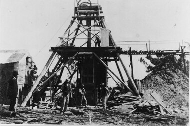
Photograph - Nell Gwynne Mine Site, 1934
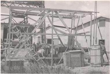
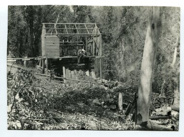
... Mine SHAFT gold mining sinking winch headframe Written ...Significant to mining history of Bendigo.Black and white photograph of Nell Gwynne mine site. Bottom level of metal headframe on left hand side of image, three men working on wooden construction immediately in front of headframe.Written in pencil on back of photograph in pencil:' Erecting Nell Gwynne Sinking Winch 16/2/35'nell gwynne gold mine, shaft, gold mining, sinking winch, headframe -
 Bendigo Historical Society Inc.
Photograph - Nell Gwynne Mine Site, 1935
... Mine SHAFT Written in pencil on back of photograph in pencil ...Significant to mining history of Bendigo.Black and white photograph of Nell Gwynne shaft showing the installation of a temporary pump at No. 3 level on 17.9.1935. Pump is supported by a metal framing.Written in pencil on back of photograph in pencil:' Erecting Nell Gwynne Sinking Winch 16/2/35'nell gwynne gold mine, shaft -
 Federation University Historical Collection
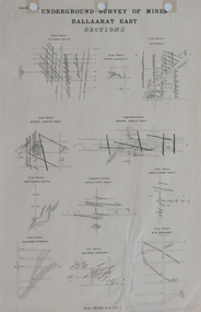
Plan, Underground Survey of Mines, Ballaarat East Sections, c1890
... Printed plan showing cross sections of various mine shafts... sections of various mine shafts Underground Survey of Mines ...Printed plan showing cross sections of various mine shaftsplan, underground survey, ballaarat east, mining -
 Stawell Historical Society Inc
Photograph, Trolly Wheel found underground when mine reopened
... Colour Photograph of underground mine shaft containing... 1982-1983 stawell Colour Photograph of underground mine shaft ...Wire Cable found underground when mine workings re-opened 1982-1983Colour Photograph of underground mine shaft containing relics used in miningstawell -
 Stawell Historical Society Inc
Photograph, Trolly Sued Underground
... Colour Photograph of underground mine shaft containing... 1982-1983 stawell Colour Photograph of underground mine shaft ...Wire Cable found underground when mine workings re-opened 1982-1983Colour Photograph of underground mine shaft containing relics used in miningstawell -
 Bendigo Historical Society Inc.
Document - HUSTLERS REEF - PLANS & SECTIONS TO ACCOMPANY BULLETIN NO 33
... Hustler's Royal Reserve Mine Park Shaft... Reserve Mine Park Shaft, Great Extended Hustler's Mine, Hustler's... Royal Reserve No 2 Mine Hustler's Royal Reserve Mine Park Shaft ...Pink page pasted onto cream card titled Plans and Sections to accompany Bulletin No 33. Hustler's Line of Reef, Bendigo by H S Whitelaw, by Authority: Albert J. Mullett, Government Printer, Melbourne. Plate No 1 to No 34. Mines mentioned: Fortuna Hustler's Mine, Hustler's Royal Reserve No 2 Mine, Hustler's Royal Reserve Mine Park Shaft, Great Extended Hustler's Mine, Hustler's Reef and Hustler's Reef No 1 Mines, Hustler's Reef Mine, Comet Mine, United Hustler's and Redan Mine, K. K. Mine, Hustler's Consols Mine, Fortuna Hustler's Mine. Department of Mines Geological Survey of Victoria 1914. Written on the back: Lightning Hill area to Summer Hill.document, hustlers reef, plans & sections to accompany bulletin no 33, geological survey of victoria, department of mines, hustler's line of reef, h s whitelaw, fortuna hustler's mine, hustler's royal reserve no 2 mine, hustler's royal reserve mine park shaft, great extended hustler's mine, hustler's reef mine, hustler's reef no 1 mine, comet mine, united hustler's mine, redan mine, k k mine, hustler's consols mine, fortuna hustler's mine, hustler's consols mine, albert j mullett, government printer melbourne -
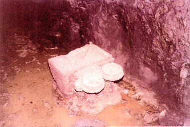
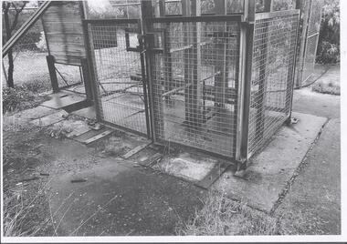
 Bendigo Historical Society Inc.
Photograph - Kangaroo Flat Gold Mine Collection: Williams United shaft
... Kangaroo Flat Gold Mine Collection: Williams United shaft... Kangaroo Flat Gold Mine Collection: Williams United shaft Western ...Black and white photocopy of original photo. Image shows close-up of Williams United shaft entry with two steel plates on top. Concrete pad surrounds shaft entry. Steel square mesh fence visible on LH side of image. On back in pencil: Williams United prior to cappingwestern mining corporation, goldmining, capping, shaft, mining regulations, williams united shaft -
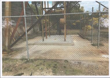 Bendigo Historical Society Inc.
Photograph - Kangaroo Flat Gold Mine Collection: Williams United shaft
... Kangaroo Flat Gold Mine Collection: Williams United shaft... Kangaroo Flat Gold Mine Collection: Williams United shaft ...Colour photocopy of original photo. Image shows Williams United shaft with steel capping on concrete base and surround. Steel ring-lock fence surrounding shaft area. On back in pencil: Williams United New Cap - Kralcopicwestern mining corporation, goldmining, capping, shaft, mining regulations, williams united shaft -
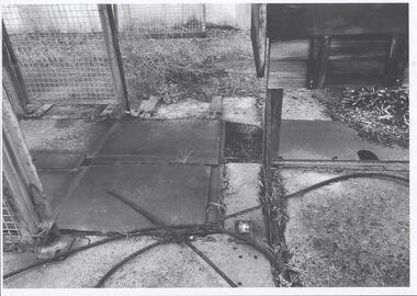
 Bendigo Historical Society Inc.
Photograph - Kangaroo Flat Gold Mine Collection: Williams United shaft, Western Mining Corporation, Bendigo Office
... Kangaroo Flat Gold Mine Collection: Williams United shaft.... Photograph Kangaroo Flat Gold Mine Collection: Williams United shaft ...Black and white photocopy of photo. Image shows square mesh steel fence around perimeter of Williams United shaft, two gates in front to allow entry to shaft area. Concrete pad surrounds shaft area. Ring-lock security fence in background.On back in pencil: Williams United prior to cappingwestern mining corporation, goldmining, capping, shaft, mining regulations, williams united shaft -
 Halls Gap & Grampians Historical Society
Photograph - B/W, C 1900
... Photo shows Poppet bead over mine shaft Five men pictured... Poppet bead over mine shaft Five men pictured Photograph B/W ...Photo shows Poppet bead over mine shaft Five men picturedPaper shows 2 copies only 1 at this timemining, gold mining, mafeking -
 Stawell Historical Society Inc
Photograph, Joe Mitchell's Mine
... down a mine shaft in bushland.... Photograph of a Group of people standing, looking down a mine shaft ...Stawell Historical Society Members visit Joe Mitchell's mine in the Ironbark, forest near Deep Lead. L to R Ian Jackson, Carmel Loats, Thelona Bullock, Allan Kingston, Betty Jackson, Betty Collins, Dorothy King, Leslie Bennett, Lawrie Bennett.Colour Photograph of a Group of people standing, looking down a mine shaft in bushland.mining, gold mininging, stawell historical society, deep lead -
 Stawell Historical Society Inc
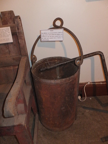
Memorabilia - Realia
... up mine shaft.... mullock and ore up mine shaft. Memorabilia Realia ...Iron Kibble Bucket for mining. Used to lift mullock and ore up mine shaft.stawell -
 Stawell Historical Society Inc
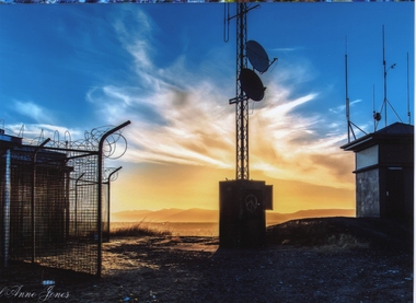
Photograph, Big Hill Sunset looking South West -- Coloured
... in the center. Stawell gold mine ventilation shaft on the left with barb.... Stawell gold mine ventilation shaft on the left. ... in the center. Stawell gold mine ventilation shaft on the left with barb ...Sunset from Big Hill looking Southwest. Fire Tower on right. Fire watch tower on right of photo. Communication Tower in the center. Stawell gold mine ventilation shaft on the left with barb wire around the fence. Spectacular sky in the background.Colored photo of sunset looking southwest on Big Hill. Fire watch tower on right of photo. Communication Tower in the center. Stawell gold mine ventilation shaft on the left. Carol Anne Jonesstawell -
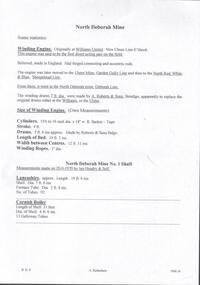 Bendigo Historical Society Inc.
Document - NORTH DEBORAH MINE - SOME STATISTICS OF THE NORTH DEBORAH MINE
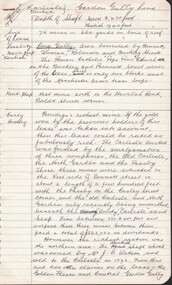
... North Deborah Mine No 1 Shaft... and Cornish boilers at the North Deborah Mine No 1 Shaft which were... Bendigo North Deborah Mine No 1 Shaft Ian Hendry Handwritten pages ...BHS CollectionHandwritten pages and typed copy of same, with information about the winding engine, winding drums and measurements of winding engine and drums. Also measurements of the Lancashire and Cornish boilers at the North Deborah Mine No 1 Shaft which were measured by Ian Hendry and Self on 20/9/1970. Albert Richardson Collection.document, gold, north deborah mine, north deborah mine, some statistics on the north deborah mine, williams united, new chum line, ulster mine, garden gully line, north red white & blue, sheepshead line, deborah line, a roberts & sons bendigo, north deborah mine no 1 shaft, ian hendry -
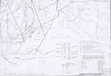 Ringwood and District Historical Society
Map - Maps, Geological Map Donvale to Chirnside Park, also Victorian Railways Maps of Hawthorn to Lilydale Line incl Ringwood to East Ringwood - 1881
... map includes location of mine shafts circa 1920..... Geological map includes location of mine shafts circa 1920 ...Faint photocopies of sections of larger maps. Geological map includes location of mine shafts circa 1920.Victory Shaft, North Victory Shaft, South Caledonia Shaft, Caledonia Shaft, North Caledonia Shaft, Black Swan Shaft, Reward Shaft, Consols Shaft, Blocks Shaft, Devonshire Shaft, Crown Shaft, Yarra Tunnel Reef Working, Bright's Shaft, Kingwood Antimony Company Shaft (Boardman's Shaft), Southern Shaft. -
 Stawell Historical Society Inc
Photograph, Amalgamated Scotchmans Mine Workings Stawell
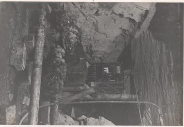
... Underground view down mine shaft or tunnel showing timbers... preserved. stawell Underground view down mine shaft or tunnel ...Black and white photograph of Amalgamated Scotchman Mine workings Stawell. Western Mining Operations - because the wooden props have been immersed in water for a century they are well preserved. Underground view down mine shaft or tunnel showing timbers holding rock walls. This photograph is in a brown cover.stawell -
 Stawell Historical Society Inc
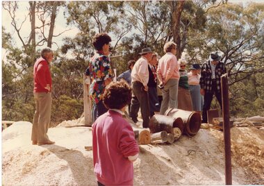
Photograph, The Magdala Mine Site, 1984
... at Magdala Mine Shaft, which is surrounded by a tall wire fence.... a large group of people looking at Magdala Mine Shaft, which ...Colour Photgraph showing a large group of people looking at Magdala Mine Shaft, which is surrounded by a tall wire fence.heritage week, magdala mine -
 Stawell Historical Society Inc
Book, Greg Cameron, The Pictorial History of Stawell Gold Mines 1944-2009 Volume -1, Feb 2020
... a mine shaft, wire fence and drain pipe on right of photo... with colour photo of a vechile emerging from a mine shaft, wire fence ...Also By the Same Author: The Gold Mines of of Stawell - 2014 A Pictorial HistoryCard Cover with colour photo of a vechile emerging from a mine shaft, wire fence and drain pipe on right of photoThe Pictorial History of Stawell Gold mines 1944-2009 Volume 1mining gold gold mining -
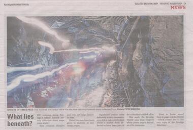 Bendigo Historical Society Inc.
Newspaper - Article on the School of Mines Natural History Collection, Sat Mar 06 2021
... , then part of it was dumped down mine shafts...., then part of it was dumped down mine shafts. bendigo school of mines ...Bendigo once had an amazing natural history collection, then part of it was dumped down mine shafts.Bendigo Weekly: Full page article entitled 'What Lies Beneath us?' bendigo school of mines, bendigo tafe, bendigo natural history collection -
Clunes Museum
Ephemera - STICKER
... . 3 x images - Clunes township, a sheep, windlass over mine... - Clunes township, a sheep, windlass over mine shaft Ephemera ...Stickers are traditionally placed on vehicle to promote destination/s traveled. This sticker essentially promotes tourism to Clunes and images gives clues about the town.Coloured adhesive backed sticker on the shape of a shield. 3 x images - Clunes township, a sheep, windlass over mine shaftClunes Vicsouvenir, sticker -
 Greensborough Historical Society
Photograph - Digital Image, Mystery mine photographs: Workers at top of shaft, 1935c
... of the mine shaft. A ladder can be seen at centre of photo.... at the mine site, at the top of the mine shaft. A ladder can be seen ...This photograph shows workers at the mine site, at the top of the mine shaft. A ladder can be seen at centre of photo..An interesting collection of photographs, the connection to Greensborough remains a mystery. Digital copy of black and white photograph, one of 30 photos of mining operations. Photos have no markings or dates. Donor unknown.tasmania, mines and mining, mining machinery -
 Stawell Historical Society Inc
Photograph, Mr Randle with the large hat at a mining scene
... Mr. Randle - Mining Scene. Three men and a boy with mine... grampians Mr. Randle - Mining Scene. Three men and a boy with mine ...Mr. Randle - Mining Scene. Three men and a boy with mine shaft. Man with large hat is Mr Randle.stawell -
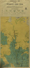 Federation University Historical Collection
Map, Geological Map of The Stieglitz Gold Field, 1940
... Kinglock Mine Engine Shaft... Garibaldi Reef Yankee Gully Kinglock Mine Engine Shaft herbert ...At the bottom of the 2nd page, there is text that reads "Geologically and topographically surveyed in 1909 by W.H. Ferguson, Assistant Field Geologist. Published 1940."Rectangular geological map edged in masking tape showing Steiglitz, Victoria. Scale 48 chains to 4 inches.steiglitz, geology, geological map, north albion, moreep, mining, mine, caribald reef, durdidwarrah, gilbraltar hill, mount pleasant gully, township of steiglitz, w.h. ferguson, garibaldi reef, yankee gully, kinglock mine engine shaft, herbert werner frederick de nully, albion gully, virago reef, mulrooney's reef -
 Bendigo Historical Society Inc.
Photograph - NEW RED, WHITE & BLUE CONSOLIDATED MINE - PHOTOS OF THE NEW RED, WHITE & BLUE CONSOLIDATED MINE
... Red White & Blue Consolidated Mine Union Shaft Dairy Hill ...Three black and white photos of the New Red, White & Blue Consolidated Mine. (a) is a small photo of the poppet legs and buildings. There are mullock heaps on the right of the picture. In the foreground are grass and a shrub. There is also an area of sand. On the back is written: New Red White and Blue Consolidated. Originally the Union Shaft. (b) is a photo of the poppet legs and buildings with a large chimney. The overhead tramway is behind the buildings. A man is standing in front of the buildings. There is grass in the foreground. Written on the back: New Red White & Blue Consolidated. Near Dairy Hill Golden Square. (c -) Photo of the buildings, poppet legs and tramway going from the poppet legs to a tall building. The building on the left has a tall chimney. On the front of this building is a sign with the name of the mine on it. In front of the building on the right is a large fuel-type tank with two ladders leaning against it. Written on the back: New Red, White & Blue Consolidated. 2,416 ft.photo, new red, white & blue consolidated mine, photos of the new red, white & blue consolidated mine, union shaft, dairy hill golden square -
 Bendigo Historical Society Inc.
Document - CARLISLE UNITED MINE GARDEN GULLY LINE
... PLACE Mining site carlisle united mine Carlisle United Mine Kent ...4 hand written foolscap pages of information about the Carlisle United Mine. Information such as area of lease, depth, locality, early history, plant & equipment, gold obtained and dividends. Also some information on the Kent Shaft. The Carlisle United was formed by the amalgamation of three companies, the Old Carlisle, the North Garden and the Passby. Also mentioned are: the Golden Fleece, Central Garden Gully, Garden Gully United and its Tribute Companies, the Constellation, Specimen Hill Mine, Kocks Pioneer, Bendigo Amalgamated Mines, the Pandora Reef, the Unity Reef, Guilford Plateau and the Nell Gwynne Reefs Mine. Also 2 typed copies of notes on foolscap paper.place, mining site, carlisle united mine, carlisle united mine, kent shaft, old carlisle, north garden, passby, mr j b watson, golden fleece, central garden gully, garden gully united, tribute companies, constellation, bendigo amalgamated mines, specimen hill mine, kocks pioneer, pandora reef, unity reef, guilford plateau, nell gwynne reefs mine -
 Bendigo Historical Society Inc.
Map - GREAT EXTENDED HUSTLER'S MINE - TRANSVERSE SECTION OF THE GREAT EXTENDED HUSTLER'S MINE
... Section of the Great Extended Hustler's Mine Old Shaft Mr Walker ...Transverse Section of the Great Extended Hustler's Mine on the Hustler's Line of Reef. Bulletin No 33, Plate No XII. Shows Poppet legs at the surface and Sill of Shaft at 788.99 feet above Sea Level, Cross Cuts and their depths, stone and geographical features encountered and their references and a number of enlarged drawing of sections of the crosscuts, Geological Survey of Victoria emblem and signed by H A Whitelaw, Underground Survey Office Bendigo, September 1913. The depths of crosscuts to No 21 were taken from plans of surveys by Mr. Walker and Mr. Craven, noted under Reference. Another note: This Saddle Reef is sketched from Mr. Walker's plan. Dividends amounting to 360,000 pounds were obtained from it. mining, parish map, great extended hustler's mine, transverse section of the great extended hustler's mine, old shaft, mr walker, mr craven, geological survey of victoria, underground survey office bendigo, h a whitelaw -
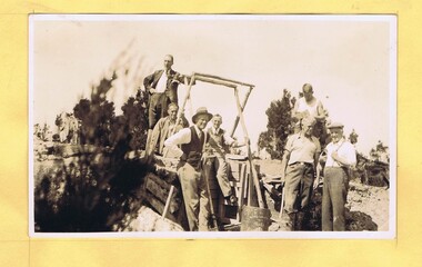
 Orbost & District Historical Society
black and white photograph, first half 20th century
... a forested gully and a mine shaft.... and a mine shaft. black and white photograph ...There is no information with this item.A black / white photograph of four men - three standing and one sitting in a half built wooden hut. It is overlooking a forested gully and a mine shaft.mining -
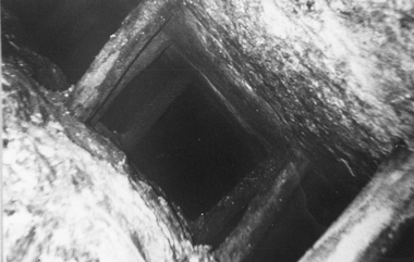
 Bendigo Historical Society Inc.
Photograph - AUSTIN COLLECTION:BRAKEMAN AT TOP OF SHAFT
... hard hat working at top of mine shaft. Central Deborah Mine... of mine shaft. Central Deborah Mine,Bendigo Photograph AUSTIN ...Black and white photo of John Murdoch,brakeman, wearing his hard hat working at top of mine shaft. Central Deborah Mine,Bendigomining, business, central deborah gold mine -
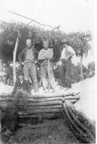
 Clunes Museum
Photograph
... MARTIN POWER WORKING A WINDLASS OVER ONE OF HIS MINE SHAFTS ... WORKING A WINDLASS OVER ONE OF HIS MINE SHAFTS Photograph ...MARTIN POWER. STORY OF HIS LIFE IN 'IF ONLY I'D LISTENED TO GRANDPA'.1 .2 .3 .4 .5 .6 BLACK AND WHITE PHOTOGRAPHS OF MR MARTIN POWER WORKING A WINDLASS OVER ONE OF HIS MINE SHAFTS MARTIN POWER - STORY OF HIS LIFE - 'IF ONLY I'D LISTENED TO GRANDPA'local history, photography, photographs, mining -
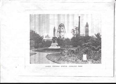 Bendigo Historical Society Inc.
Photograph - PHOTOCOPIED PHOTO OF QUEEN VICTORIA STATUE, ROSALIND PARK
... Statue , Rosalind park. Hustlers Royal Reserve City Mine shaft... Victoria Statue , Rosalind park. Hustlers Royal Reserve City Mine ...faded Photocopied black and white photo of Queen Victoria Statue , Rosalind park. Hustlers Royal Reserve City Mine shaft workings, and Post Office in the background.photograph, building