Showing 93 items matching "mount dandenong north"
-
 Ringwood and District Historical Society
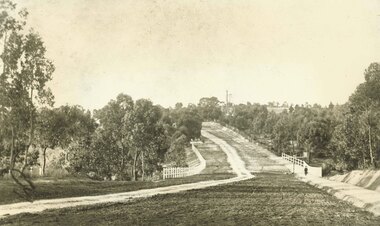
Photograph, Maroondah Highway East, Ringwood- 1900. Sandy Creek Bridge, Maroondah Hwy
3 photographs ( 2 large black and white, 1 small sepia)Written on all copies: "New Sandy Creek Bridge". Typed below large photograph: "Maroondah Highway Ringwood looking east. To right of bridge is now Ringwood Lake. Mount Dandenong Road turnoff to right at top of rise with antimony mine in background - 1900". -
 Ringwood and District Historical Society
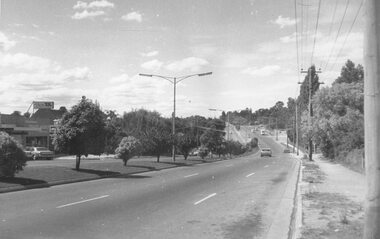
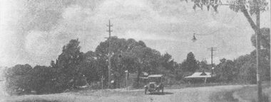
Photograph, Maroondah Highway East, Ringwood in 1973. Eastward view along Maroondah Highway towards Mount Dandenong Road
Black and white photographTyped on back of photograph: "Maroondah Highway by the lake. Looking east towards Mt. Dandenong Rd. - 1973". Ringwood Lake is on the right hand side of the highway. -
 Ringwood and District Historical Society
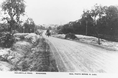
Photograph, Maroondah Highway East, Ringwood- c.1920. "Healesville Road, Ringwood" postcard featuring westward view along Whitehorse Road towards Mount Dandenong Road
4 photographs (2 large black and white, 2 small sepia postcard)Postcard labelled Healesville Road, Ringwood. Typed under large copy: "Looking down a dry Maroondah Highway from outside (eventual) Civic Centre site towards Mt. Dandenong Rd corner." -
 Ringwood and District Historical Society
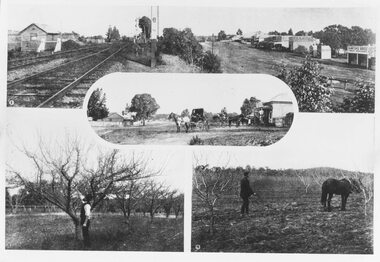
Photograph, Photos from a Weekly Times newspaper article featuring images of early Ringwood and East Ringwood circa 1910 (6 photos), Circa 1910
Shops, houses and hotel(s) were originally regarded as being in central Ringwood and later as Ringwood East after the commercial and residential developments gradually centered further west around the Railway Station precinct after train services commencedFive photographs; Ringwood Railway Crossing; Ringwood Shopping Strip; Pruning Demonstration; Shops, houses and hotel(s) in Mount Dandenong Road; Ploughing.Written on backing sheet, "Photos from Weekly Times. Check with H.A." -
 Ringwood and District Historical Society
Photograph, Club Hotel, Mount Dandenong Road, Ringwood East - 1960
Written on back of photographs, "Club Hotel Ringwood East. 1960." "Club Hotel, Mt. Dande Rd. 1960" and "1960 Club Hotel" -
 Ringwood and District Historical Society
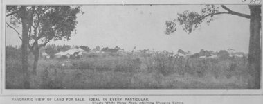
Photograph, Image used for land sale promotion of Pratt's Junction Estate opposite Mount Dandenong Road, Ringwood - 24/11/1923
Catalogue card reads, "Pratt's Junction Estate - 24/11/1923, 86 lots". -
 Ringwood and District Historical Society
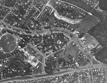
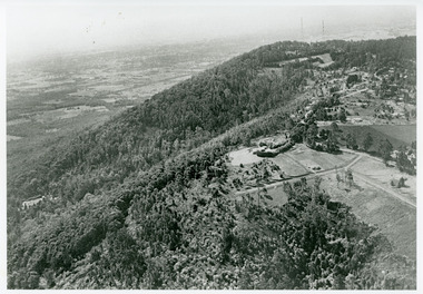
Photograph, Aerial view showing East Ringwood oval, Mount Dandenong Road, and Civic Centre, Braeside Avenue/Maroondah Hwy, c.1970
Aerial view showing East Ringwood oval, Mount Dandenong Road, and Civic Centre, Braeside Avenue/Maroondah Hwy, c.1970. -
 Ringwood and District Historical Society
Photograph, Whitehorse Road and Mount Dandenong Road, including early electric installation of street lighting. (Undated)
Written on back of photograph, "Whitehorse Road and Mount Dandenong Road". Catalogue card reads, "Early electric installation of street lighting". -
 Ringwood and District Historical Society
Photograph, Ringwood's first Police Station, 32 Mount Dandenong Road. (note room at left)
Written on back of photograph, "32 Mount Dandenong Road. Ringwood's first Police Station (note room at left). -
 Ringwood and District Historical Society
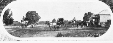
Photograph, Mount Dandenong Road, Ringwood. Blood's store on right, Club Hotel behind tree, Cornell's store on left. c.1900-1910
Written on backing sheet, "Blood's store on right, Club Hotel behind tree, Cornell's store on left". -
 Ringwood and District Historical Society
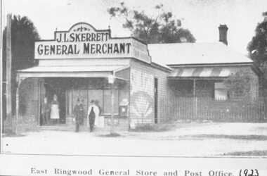
Photograph, Skerrett's Store and Post Office, 1923. Diagonally opposite from Club Hotel in Mount Dandenong Road
Catalogue card reads, "Skerrett's Store and Post Office, 1923. Diagonally opposite from Club Hotel." -
 Ringwood and District Historical Society
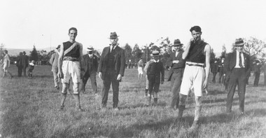
Photograph, Footballers at Mount Dandenong Road Recreation Ground oval circa 1914
Footballers at Mount Dandenong Road Recreation Ground oval circa 1914. Man in centre with hat and pipe possibly A. J. (Jun) Sugden, headmaster of Wantirna School, and Bob Skerrett on right hand side with hat.Catalogue card reads, "Possible? Man in centre with hat and pipe A. J. (Jun) Sugden, headmaster of Wantirna School. RHS with hat (front) ? Bob Skerrett?" -
 Ringwood and District Historical Society
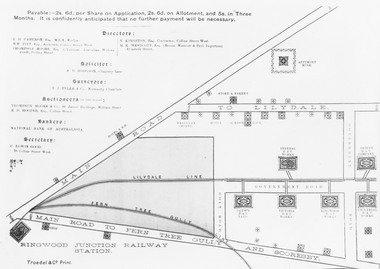
Photograph, Land sale brochure map of Ringwood's early main central area around Mount Dandenong Road - c.1880s
Catalogue card reads, 'Map of Ringwood East'. -
 Ringwood and District Historical Society
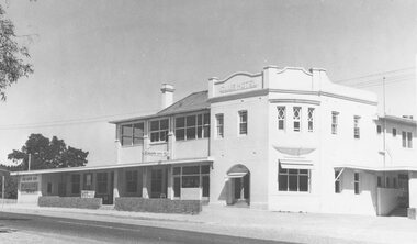
Photograph, Club Hotel, Mount Dandenong Road, East Ringwood in February 1960
Black and white photographs of Club Hotel February 1960 (1 original, three copies). The hotel has a long association with the Reddish family, thus given the name of "Daisy's Hotel". Included 2 copies of the photograph. Ryman Healthcare bought the site in 2019, including the garden supply business next door, making up a 2.2ha area. The proposal was for a $220 million retirement village to be built. The location is next to Ringwood Lake with the old hotel being knocked down in the early 2020s. -
 Ringwood and District Historical Society
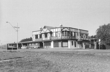
Photograph, Club Hotel, Mount Dandenong Road, Ringwood East 1973
Black and white photographs of Tudor style Club hotel -
 Marysville & District Historical Society
Booklet - Paperback booklet, Maroondah Bushwalking Club Inc, Day Walks Around Marysville, 1996
A booklet outlining day walks of various difficulties in and around the surrounds of Marysville.Paperback booklet. Front cover shows title with a cartoon drawing of a pair of walking boots. Back cover shows details of the publisher and distributor of the publication.non-fictionA booklet outlining day walks of various difficulties in and around the surrounds of Marysville.marysville, victoria, day walks, bushwalking, maroondah bushwalking club, cathedral range, sugarloaf peak, neds gully, maroondah highway, woods lookout, cement creek, acheron, lake mountain, snowy hill, cumberland reserve, wilks creek, mount strickland, the beeches, mount margaret, stevensons falls, steavensons falls, de la rue lookout, oxlee lookout, keppel lookout, keppel hut, north jawbone peak, cumberland scenic reserve, acheron road, buxton, man o war track, phantom falls, keppel falls, athols abbey, sunds road, trestle track, booklet -
 Marysville & District Historical Society
Photograph (Item) - Black and white photograph, Fernshaw, c1900
An early black and white photograph taken at Fernshaw.An early black and white photograph taken at Fernshaw. Fernshaw was a rural township 63 km north-east of Melbourne and 10 km north-east of Healesville. Situated on the Watts River, near where a log had fallen making a convenient crossing, Fernshaw was settled in the 1860s. It provided good country for orchards and berry growing. The location was at the foot of Blacks Spur, with Mounts Juliet and Mondah rising on either side, providing spectacular scenery. There were nearby fern gullies giving rise to the name – ‘shaw’ is old English for thicket or wood. By 1875 Fernshaw had a post office (1865), two hotels, a school (1871) and stores. It was famed for its beauty, attracting tourists. In 1886 the Melbourne and Metropolitan Board of Works began work on the Watts River water catchment scheme – later to become Maroondah – and the Board obtained approval for the catchment country to be reserved and kept free of settlement. This required the removal of the Fernshaw township, which was completed by about 1890. The area was described in the 1903 Australian handbook:ARMSTRONG COLLECTION 42 STATION STREET/ SANDRINGHAM 3191/ TEL. (03) 9521 5442/ IAN M.L. ARMSTRONG OAMfernshaw, healesville, watts river, orchard, berry orchard, blacks spur, black spur, mount juliet, mount mondah, maroondah dam, victoria -
 Ringwood and District Historical Society
Document - Copy of Lands Department Field Notes - Subdivision of Police Reserve at Ringwood, County of Mornington, Field Notes 1900/293 - Part of O.P. R72C surveyed 1900
Foolscap size photocopy of survey map with handwritten notations. References include Mount Dandenong Road, Dublin Road, Patterson Street, Melbourne to Lilydale railway line, I certify that this is a correct copy of recorded observations made by my assistant (signed) W. Thorn, Staff Surveyor. -
 Ringwood and District Historical Society
Document - Copy of Lands Department Field Notes - Subdivision of Ringwood, Victoria, Field Notes 1904/188 - Part of O.P. R72D Surveyed 28.4.1904
Foolscap size photocopy of survey map with handwritten notations. References include Mount Dandenong Road to Lilydale, M. Dickson (sold), Church of England, P. Schonnenberger, Helen Lindsay, W.B. iron roof & shingles, I certify that this is a correct copy of the recorded observations and measurement made by me and my assistant (signed) W. Thorn 12/5/04 -
 Ringwood and District Historical Society
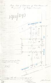
Document - Copy of Lands Department Field Notes - Survey of Extension to Recreation Reserve, Township of Ringwood, Victoria, Field Notes 1907/436 - Part of O.P. R72D Surveyed 6.8.1907
Foolscap size photocopy of survey map with handwritten notations. References include New Lilydale Road 3 chains wide (Mount Dandenong Road), Silurian, undulating, poor grass, Corner cut off to allow for road in future subdivision, Old recreation reserve, (circled area) oval now in use, A. Gisler, I certify that this is a correct copy of the recorded observations & measurements made by me personally (signed) R.J. Gray 6/8/07. -
 Ringwood and District Historical Society
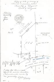
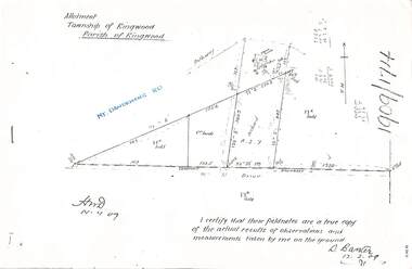
Document - Copy of Lands Department Field Notes - Parish of Ringwood, Victoria, Field Notes 1909/174 - Part of O.P. R72D surveyed 12.3.1909
Foolscap size photocopy of survey map with handwritten notations. References include Mount Dandenong Road, pathway, 2 room house, scillion, shed, WC, 17C sold, Cr lands, orchard, 17E sold, Township boundary, I certify that these field notes are a true copy of the actual results of observations and measurements taken by me on the ground (signed) D. Barker 12.3.09. -
 Ringwood and District Historical Society
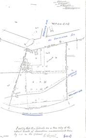
Document - Copy of Lands Department Field Notes - Parish of Ringwood, Victoria, Field Notes - OP34838 - surveyed in 1919 by D. Barker
5615b Foolscap size photocopy of survey map with handwritten notations. References include Braeside Avenue, Mount Dandenong Road, Rosedale Court, Railway Avenue, cyclone fence, Sec A, WB house, old tennis court netted, stable, old shed, tank stand, orchard, Township Boundary, netting fence, Railway fence, Ringwood to Lilydale Railway, I certify that these fieldnotes are a true copy of the actual results of observations & measurements taken by me on the ground (signed) D. Barker (1919). -
 Ringwood and District Historical Society
Map, Plan of Country Lands in the Parishes of Nunawading Ringwood and Scoresby - circa 1855
Blueprint copy of Survey Map detailing original Selectors' names and property locations. List of Parish map references including property bearings, distances in Links, and markings on trees. Descriptive remarks include areas marked "Farmer's Common", "Poor soil thickly/moderately timbered with stringy bark", and location of water and firewood reserves."Surveyed and plotted by N.M. Bickford, Superintendant of Mr. Hodgkinson's Field Party". "The land comprised in this survey is of inferior quality, moderately undulating, and thickly wooded. It is watered by Dandenong Creek and Deep Creek." Inset map showing location of (*proposed) cemetery on southern corner of Lillydale Road from Melbourne and Sawmill Road, later Mount Dandenong Road. (*Cemetery did not eventuate.) -
Ringwood and District Historical Society
Legal record - Fire Insurance document (C.E.Carter), Fire Insurance - Commercial Union Assurance Co Ltd for Charles W Bruce, 1943
Standard form of Fire Insurance Policy issued by Commercial Union Assurance Co LtdPolicy issued to Charles W. Bruce, for dwelling in Mount Dandenong Road, Ringwood. -
 Mt Dandenong & District Historical Society Inc.
Photograph, View Towards Mt Dandenong 1961, 1961
Looking north towards Mt Dandenong 'City Lights' estate 1961. Viola Court in foreground, Ridge Road winding up the hill towards the Observatory.mount dandenong, ridge road, viola court, city lights estate -
 Mt Dandenong & District Historical Society Inc.
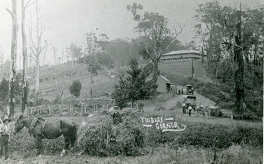
Photograph, The Busy Corner, 1907
View of Kalorama gap taken in 1907 showing Eliza Hand outside Beulah Tea Rooms, Briartys Coach, Dodd's Grocery cart and Meat Cutting cart. In foreground Fred Jeeves is standing and Theo Hand on hay. Mountjoy is in the background.This photograph has a detailed inscription on the back handwritten by John Lundy-Clarke in 1974.The Kalorama Gap in 1907. The coach road comes from right behind old stump. The shop was Hand's Beulah Tea Rooms soon to become the Mt Dandenong North Post Office. Big woman in black was Mrs Hand. wagon was Dodd's Grocery cart. "Mountjoy" on hilltop. The wagon with man was the first coach on the mount (Briartys). Small cart was Dodd's meat cutting cart. Horse at sledge was "Blossom" boy at her head was Fred Jeeves. Boy on sledge was Theo hand. Elm trees in centre of picture with Prices sign advertising shop and newsagency above them.mountjoy, beulah tea rooms, fred jeeves, theo hand, dodd's grocery cart, cart, coach, briartys -
 Mont De Lancey
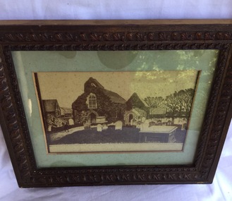
Drawing - Picture, Unknown
A black and white drawing of St. Sampson's Church and surrounds, Guernsey. It has a brown wooden decorative frame with a green mount and glass front. pictures, drawings, st sampson's church -
 Mont De Lancey
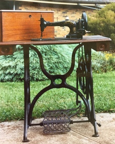
Functional object - Sewing Machine, Wertheim, early 1900's
Wedding gift to Mrs. and Mrs. Wandin Sebire in 1905. From their home in Sebire Avenue Wandin.An antique black painted cast iron treadle sewing machine with gold decoration on the front and mounted on a wooden base with one small drawer on each side and a foot operated treadle below. It has a wooden detachable cover. There are two cotton reels included.Plate reads "Deutsche Nahmaschinen Fabrik. Vormals. Jos. Werthheim : Frankfurt a/m".Stamped Hugo Werthheim.sewing machines, cabinet sewing machines, machines, sewing equipment -
 Mont De Lancey
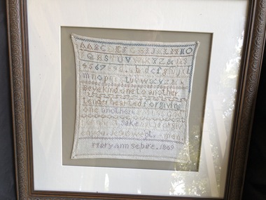
Sampler, Circa 1869
Sampler worked by Mary Ann Sebire at age 11. Eldest child of Henry and Martha Sebire.Embroidered Sampler with letters of the Alphabet and words. Cream mount in a wooden frame.textile samplers -
 Mont De Lancey
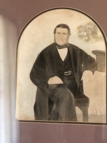
Framed Photograph, 1860's
Hand painted glass plate photograph of a gentleman, in frame with tray mount board and wood grain frame.photographic plates