Showing 75 items
matching mt dandenong north
-
 Ringwood and District Historical Society
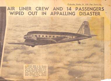
Newspaper - clipping, The Sun News Pictorial, DC2 Kyeema crashed into Mt Dandenong. Crew and 14 passengers killed, 25-Oct-38
The Sun News Pictorial newspaper reports of aircraft disaster. -
 Ringwood and District Historical Society
Document - Recollection, Unknown, Story of William and James Smith - Ringwood from 1868 to 1920, c.1950
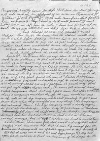
Single page handwritten notes by unknown author briefly outlining family history of William and James Smith in Ringwood from 1868 to 1920. Page ends mid-sentence however no trace of subsequent page/s. Further information on the William and James Smith and family (expanding on these notes?), is contained in the book " A History of Croydon - Second Volume" by Muriel McGivern (pages 170-176) +Additional Keywords: Smith, William / Smith, James / Boardman / Pierce / Robason / antimony William and James Smith were credited for discovering antimony ore near the corner of Mt Dandenong Road and Maroondah Highway, with the main mine later developed by Pierce Boardman. -
 Ringwood and District Historical Society
Map, Department of Mines, Plan of area applied for under the mining leases regulations in the township of Ringwood between Maroondah Highway and Mt. Dandenong Road. Mining District of Castlemaine, County of Mornington, Parish of Ringwood T Area 58(A) 2 (R)15(P) Acres, Roods, Perches. 1934, 20-Feb-34
Map of the township of Ringwood with subdivisions between Maroondah Highway and Mt. Dandenong Road. the area applied for on lease No.8210 by E.G.Browne.Mining District of Castlemaine, County of Mornington, Parish of Ringwood T Area 58(A) 2 (R)15(P) Acres, Roods, Perches.Buff coloured sheet foolscap with black printing showing map of the township of Ringwood between Maroondah Highway and Mt. Dandenong Road. Mining District of Castlemaine, County of Mornington, Parish of Ringwood T Area 58(A) 2 (R)15(P) Acres, Roods, Perches +Additional Keywords: Browne E.G. -
 Ringwood and District Historical Society
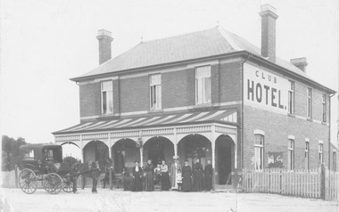
Photograph - Newspaper Clipping, Early View of Club Hotel, Ringwood East
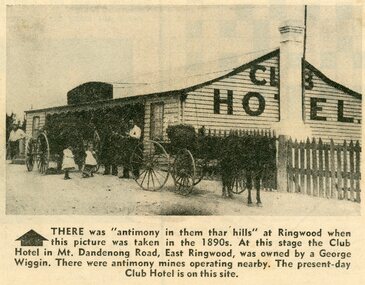
The newspaper clipping caption is incorrect. The Club Hotel featured in the article was located on the north side of Mount Dandenong Road. It was destroyed by fire in 1890 prior to re-opening later on the south side where it operated until sale and demolition in 2020 to make way for a retirement village. (See PDF attached - "SS0067 Vic Collections 3754b - Club Hotel Fire 1890").Early View of Club Hotel, Ringwood East. Weatherboard with iron roof. Single chimney on one end. Picket fence on RHS. Two horse-drawn vehicles standing out front including three adults and two children. Source/date of newspaper unknown. Later newspaper item also attached reporting hotel being destroyed by fire in 1890.Caption: There was 'antimony in them thar hills' at Ringwood when this picture was taken in the 1890s. At that time the Club Hotel in Mt Dandenong Road, East Ringwood was owned by a George Wiggin. There were antimony mines operating nearby. The present-day Club Hotel is on this site. -
 Ringwood and District Historical Society
Photographs, Rebboch, Myil, Restaurants and cafes in Ringwood/Ringwood East photographed by Myil Rebboch - 1999-2000, 1999 - 2000
Bundle of 21 photographs in Agfa folder. Restaurants and cafes in Ringwood/Ringwood East 1999 - 2000. Taken by Myil Rebboch. Smorgy's - corner of Oban Road and Maroondah Highway (3211_Smorgy's_001) Red Rooster - corner of Beaufort Road and Maroondah Highway (3211_Red Rooster_002) Kublai Mongolian - corner of Beaufort Road and Maroondah Highway (3211_Kublai_003) Nikos Greek Tavern - Mt Dandenong Road opposite Carcoola Road (3211_Nikos Greek Tavern_004) Turtle Den - Railway Avenue Ringwood East (3211_Turtle Den_005) Maroondah Sporting Club - Mt Dandenong Road (3211_Maroondah Sporting Club_006) Hungry Jack's - corner of Mt Dandenong Road and Maroondah Highway (3211_Hungry Jack's_007) Daisey's Hotel - Mt Dandenong Road (3211_Daisey's Hotel_008) Lone Star - Maroondah Highway (3211_Lone Star_009) Canton - Murray Place (3211_Canton_010) Cafe Thirty-Five - Ringwood Street (3211_Cafe Thirty-Five_011) Cafe Ringwood Market (3211_Cafe Ringwood Market_012) Phoolwari - Eastland (3211_Phoolwari_013) Jamaica Blue - Eastland (3211_Jamaica Blue_014) Gourmet - Eastland (3211_Gourmet_015) Muffin Break - Eastland (3211_Muffin Break_016) Food Terrace - Eastland (3211_Food Terrace_017) Croissant - Eastland (3211_Croissant_018) Emerald Hill - Eastland (3211_Emerald Hill_019) Fasta Pasta - Eastland (3211_Fasta Pasta_020) Eating In - Eastland (3211_Eating In_021) -
 Ringwood and District Historical Society
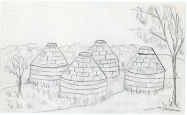
Work on paper - Pencil sketch, Artist unknown, initials D.M, Sketch of pottery kilns at East Ringwood, corner of Velma Grove and Mount Dandenong Road (Oxford Road). Kilns shut down in 1926, c.1926
Sketch of the four pottery kilns at East Ringwood, corner of Velma Grove and Mount Dandenong Road (Oxford Road). The kilns shut down in 1926. Judging by the handwriting, the artist and author appears to be John Rodaughan, East Ringwood historian, whose other works include history on Burnt Bridge Hotel and other parts of East Ringwood. The back of the sketch includes a rough hand-drawn map, that appears to be of the insulator works area, between Mt Dandenong Road and Evon Avenue. The timeline includes generic milestones in blue ink and those associated with Ringwood in red writing.Kilns; D.M. -
 Ringwood and District Historical Society
Photograph, House and shops, Corner Whitehorse and Mt. Dandenong Roads, Ringwood 1964 (4 views)
Written on backing sheets: SS0087: Corner Whitehorse and Mt. Dandenong Roads 1964. Demolished for roadworks. Originally a shop SS0088: Corner Whitehorse and Mt. Dandenong Roads 1964 SS0089: House corner Mt. Dandenong and Federal Roads. One time butchers shop. January, 1964 SS0090: Geraghty home 1964. Corner Mt. Dandenong Rd. and Federal (East Cr.). Originally a butchers shop for Ringwood East. Now demolished. -
 Ringwood and District Historical Society
Photograph, Mt. Dandenong Road, Ringwood. Klix's Tea Rooms. 1920s
Written on backing sheet, "Mt. Dandenong Road. Klix's Tea Rooms. 1920s". -
 Ringwood and District Historical Society
Photograph, Club Hotel, Mount Dandenong Road, (East) Ringwood in 1897
Black and white photograph.(several copies) of brick hotel with veranda. Horse and card outside and group of people standing in front of veranda.Typed below one photograph, "Club Hotel Mt. Dandenong Rd. 1897". Another adds "Incorporated in present structure". A third copy is labelled "Mrs Sweeney", possible owner. -
 Ringwood and District Historical Society
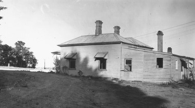
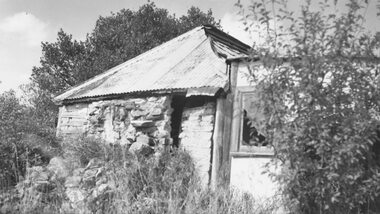
Photograph, Stone Cottage - 1965, probably not 32 Mt Dandenong Rd
Old Stone Cottage with tin roof.Written on backing sheet, "1965 - I don't think this is 32 Mt. Dand." -
 Ringwood and District Historical Society
Photograph, Laying pipeline near Mt. Dandenong Road, in Whitehorse Road, Ringwood (undated)
Written on back of photograph, "Laying pipeline near Mt. Dandenong Road, in Whitehorse Road". -
 Ringwood and District Historical Society
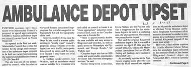
Newspaper, Newspaper articles on proposed ambulance depot in North Ringwood
Proposed ambulance depot at 127-9 Oban Road, North Ringwood in 1995-6 but, due to protests, considered 8 Grey Street, East Ringwood. The ambulance depot, at 2021, is located at the corner of Dublin and Mt Dandenong Roads.Newspaper articles from Eastern Post and Ringwood Mail pasted on A4 sheets -
 Ringwood and District Historical Society
Photograph, Maroondah Highway East, Ringwood in 1973. Eastward view along Maroondah Highway towards Mount Dandenong Road
Black and white photographTyped on back of photograph: "Maroondah Highway by the lake. Looking east towards Mt. Dandenong Rd. - 1973". Ringwood Lake is on the right hand side of the highway. -
 Ringwood and District Historical Society
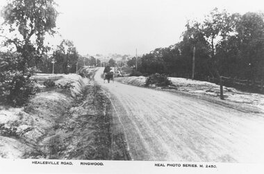
Photograph, Maroondah Highway East, Ringwood- c.1920. "Healesville Road, Ringwood" postcard featuring westward view along Whitehorse Road towards Mount Dandenong Road
4 photographs (2 large black and white, 2 small sepia postcard)Postcard labelled Healesville Road, Ringwood. Typed under large copy: "Looking down a dry Maroondah Highway from outside (eventual) Civic Centre site towards Mt. Dandenong Rd corner." -
 Ringwood and District Historical Society
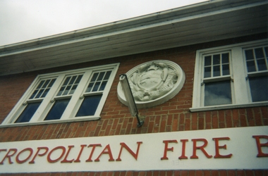
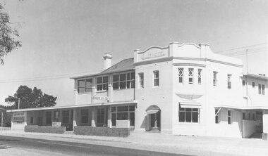
Photographs, Ringwood Fire Station at 255 Maroondah Highway circa 1998
This fire station was closed and a new one opened on Maroondah Highway on the site of the old miner's cottage near the corner of the Highway and Mt Dandenong Road.Five coloured photographs of the Ringwood fire station at 255 Maroondah Highway and of the fireman's house when it was sold. It later became 'The Fire Station Restaurant.' -
 Ringwood and District Historical Society
Photograph, Club Hotel, Mount Dandenong Road, Ringwood East - 1960
Written on back of photographs, "Club Hotel Ringwood East. 1960." "Club Hotel, Mt. Dande Rd. 1960" and "1960 Club Hotel" -
 Ringwood and District Historical Society
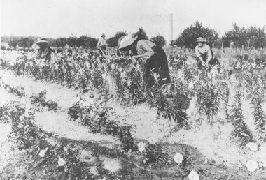
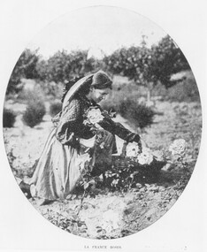
Photograph, Gathering Lancifolium Lilies and Queen Victoria Roses at Mr. John Hill's Nursery, Ringwood. 1905
Black and white photograph (2 copies)Typed under photograph: Gathering Lancifolium lillies and Queen Victoria roses at Mr John Hill's nursery, Ringwood. Typed below heading of one copy- "Mr. J. Hill's Nursery, Mt Dandenong Rd, Ringwood East. 1905. Written on back of photograph: "Hill Bros. Nursery 1905. (Mr. John Hill and daughters). Mt Dandenong Rd Ringwood East." Additional words- "Note Chimney stack (125' ?) from one of Ringwood brickworks on Dublin Rd. -
 Ringwood and District Historical Society
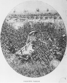
Photograph, Collecting Dahlias - Mr. Hill's Flower Farm - Mt. Dandenong Rd, Ringwood 1905
Black and white photograph (4 copies)Typed note at bottom of one photograph- "Mr. Hill's Flower Farm - Mt. Dandenong Rd. Miss Hill collecting dahlias. 1905." Typed note on back of separate photograph- "John Hill's flower farm 29/3/05, Mt Dandenong Rd, Ringwood East. Later Howship's flower farm, subdivided, name retained in street name. Miss Elvie Hill. -
 Ringwood and District Historical Society
Photograph, Collecting dahlias Hill Bros Flower Farm, Ringwood 1905
Black and white photograph (2 copies)Written under one photograph- "Hill Bros Nursery, Mt Dandenong Rd, 1905. In 1912 sold to Howships. Written on back of one copy, " 'Australian' 29.3.05. John Hill's Flower Farm Mt. Dandenong Rd., later Howship's Flower Farm, subdivided, name retained in street name. Miss Elvie Hill." -
 Ringwood and District Historical Society
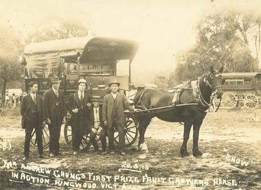
Photograph, Andrew Chung, Orchardist, of Mt. Dandenong Rd Ringwood. 1913
Sepia photograph (original), with 3 black and white copies. Photographer- George Wall & Co Photo Experts, 131 Chapel Sr, Balaclava.Written on original photograph- "Mr. Andrew Chung's first prize, Fruit Growers Horse in Action. Ringwood. Vict. Aust. 22.3.13." Typed beneath one copy- "Andrew Chung, Orchardist, of Mt. Dandenong Rd. 1913"agriculture -
 Ringwood and District Historical Society
Photograph, Ringwood Birdseye - Looking towards Ringwood from later site of Civic Centre in Braeside Avenue, Ringwood East
Typed below photograph, "Looking towards Ringwood from present site of Civic Centre. Old Catholic Church which stood on Maroondah Hwy. and Mt. Dandenong Rd. intersection can be seen on right. Maroondah Hwy. can be seen where it goes past lake, also station masters residence, and houses in Pitt St. and Bedford Rd." -
 Ringwood and District Historical Society
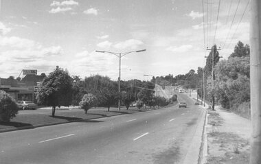
Photograph, Civic Centre, Ringwood, 1970
Written on back of photograph, "Civic Centre, Ringwood, 1970" and "Mt. Dandenong Road just widened". -
 Ringwood and District Historical Society
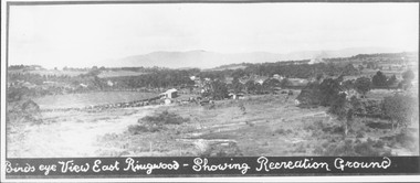
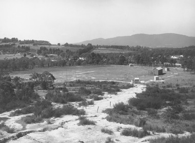
Photograph, Birds eye view East Ringwood - Showing Recreation Ground. Mt. Dandenong Rd. on right. Taken from present Civic Centre site. Football final in progress - 1923
Written below photograph, "Birds eye view East Ringwood - Showing Recreation Ground". Typed below photograph, "Mt. Dandenong Rd. on right. Taken from present Civic Centre site. Football final in progress - 1923". -
 Ringwood and District Historical Society
Photograph, East Ringwood oval c.1928
Typed below photograph, "View of East Ringwood oval from present site of Civic Centre. Mt. Dandenong Rd. on right - 1935". Catalogue card reads, "Suggest this photo is taken early 1920s.... E.R.F.C. was established approx. 1928. Prior to this the Ringwood F.C. played on the oval". -
 Ringwood and District Historical Society
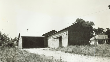
Photograph, Guest's Bakehouse, Mt. Dandenong Rd. Corner Braeside Ave. 1964". Catalogue card states demolished 1972
Typed below photograph, "Guest's Bakehouse, Mt. Dandenong Rd. Corner Braeside Ave. 1964". Catalogue card states demolished 1972. -
 Ringwood and District Historical Society
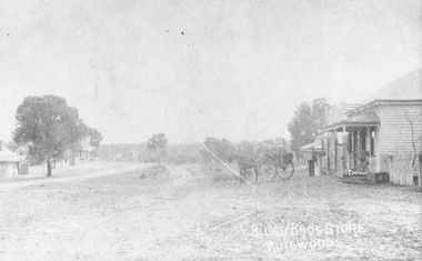
Photograph, Original Blood Bros. store, Ringwood - Mt. Dandenong Rd. looking to Whitehorse Rd. c.1900
Written on backing sheet, "Original Blood Bros. store, Ringwood - Mt. Dandenong Rd. looking to Whitehorse Rd. Possibly Club Hotel on left and Blood Store late J. Skerrett." c1900. -
 Ringwood and District Historical Society
Photograph, Club Hotel, Ringwood from Whitehorse Road. Mt. Dandenong Road to old East Ringwood looking south. Taken about 1900-10
Catalogue card reads, "Club Hotel, Ringwood from Whitehorse Road. Mt. Dandenong Road to old East Ringwood looking south. Taken about 1900-10". Label below photograph is dated 1904. -
 Ringwood and District Historical Society
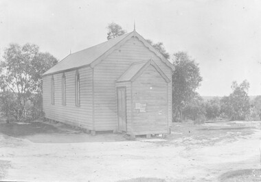
Photograph, United Methodist Church - 1904
Black and white photograph of wooden church.Typed below photograph, "United Methodist Church 1904 - Cnr. Mt. Dandenong Rd. & Whitehorse Road." Similar inscription on backing sheet. -
 Ringwood and District Historical Society
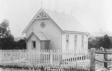
Photograph, Roman Catholic Church, Ringwood 1915 (Built 1893)
Black and white photograph of small wooden church.Typed below photograph, "Roman Catholic Church - Whitehorse Rd. opposite Mt. Dandenong Rd. intersection - 1915" Written on back of another copy: Built 1893 at (one stage) in grounds of R.C. School. Photographer Brian Pump. -
 Ringwood and District Historical Society
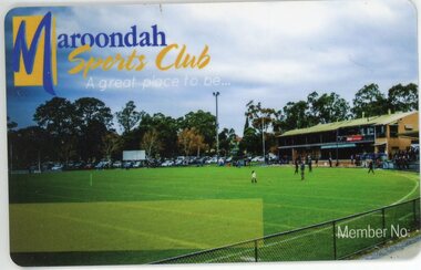
Card - Membership, Maroondah Sports Club Membership Card, Ringwood C2021
Plastic Membership card from the defunct Maroondah Sports Club, cnr Mt Dandenong and Dublin Roads, Ringwood East. (Found in disused club area when building was being used a voting Centre for Federal Elections).