Showing 38 items matching "nell street greensborough"
-
 Greensborough Historical Society
Document - Leaflet, Berry Street Victoria North East Region, North East Foster Care for children & adolescents, 2000c
Publicity brochure for North East Foster Care, Nell Street Watsonia WestTri-fold leaflet, printed in colour both sidesnon-fictionfoster care, north east foster care, watsonia, berry street victoria -
 Greensborough Historical Society
Flyer - Leaflet, Diamond Valley Arts Society, Diamond Valley Arts Society: Subscription form, Classes and Entry form for Artists on Parade, 2005c
... college nell street watsonia 3 documents, printed in black on pink ...Leaflets on various aspects of the Diamond Valley Arts Society's operations, including handwritten details on the reverse of the entry form: "The Diamond Valley Arts Society, formed 1970, is thriving in its new home at Greensborough College, Nell St, Watsonia. The Society offers a range of programmes for both beginners and experienced painters, potters and sculptors. Classes are also conducted for juniors on Saturdays"; contact details follow.3 documents, printed in black on pink, yellow and orange paperdiamond valley arts society, greensborough college, nell street watsonia -
 Greensborough Historical Society
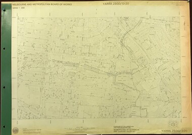
Map, Melbourne and Metropolitan Board of Works. Survey Division, MMBW, Yarra 2500 / 13.20. Greensborough, Montmorency and Watsonia, 1979_03
Melbourne and Metropolitan Board of Works. Yarra 2500 [base map] 13-20. Greensborough, Montmorency and Watsonia. Parishes of Nillumbik 3310 and Keelbundora 2856. Municipalities of Eltham 238 and Diamond Valley 257. Prominent streets include: Nell Street, Nepean Street and Alexandra Street. Includes Montmorency High School.MMBW Map in 1:2500 [scale] series. Cream parchment with green tape reinforcing on edges and punched holes on left edge.mmbw, melbourne and metropolitan board of works, shire of diamond valley, greensborough - maps, montmorency - maps, watsonia - maps -
 Greensborough Historical Society
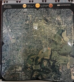
Aerial Photograph, AAM Photographics, Heidelberg AAM1969c 106, 24/11/1991
... , Greensborough & Viewbank. North boundary Nell Street, East boundary... boundary Nell Street, East boundary Plenty River, South boundary ...One of an overlapping series of aerial photographs of the Heidelberg/Greensborough areas in 1991, covering the Simpson Barracks, Greensborough & Viewbank. North boundary Nell Street, East boundary Plenty River, South boundary Lower Plenty Road.Laminated colour aerial photographsimpson barracks, greensborough, viewbank -
 Greensborough Historical Society
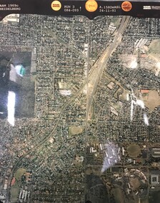
Aerial Photograph, AAM Photographics, Heidelberg AAM1969c 084, 24/11/1991
One of an overlapping series of aerial photographs of the Heidelberg/Greensborough areas, covering Greensborough, Macleod, Viewbank & Yallambie. North boundary Nell Street, South boundary Simpson BarracksLaminated colour aerial photographgreensborough, viewbank, yallambie -
 Greensborough Historical Society
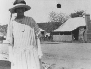
Photograph - Digital image, Nell Herbert - Main Street, 1925c
... ) standing in Main Street Greensborough circa 1925.. main street ...Photograph of woman (Nell Herbert) standing in Main Street Greensborough circa 1925..Digital copy of black and white photograph.main street greensborough, nell herbert -
![Pamphlet, Greensborough Secondary College Senior Campus 1991 [Gr8750], 1991_](/media/collectors/4f729f5697f83e03086015b8/items/598bb93821ea6919dc9e17bc/item-media/5992c3da21ea671398d0e5d5/item-fit-380x285.jpg) Greensborough Historical Society
Greensborough Historical SocietyPamphlet, Greensborough Secondary College Senior Campus 1991 [Gr8750], 1991_
The College was established in 1990. The Senior Campus was located in Nepean Street, near the Junior Campus in Nell Street. This is an information flyer outlining the Senior Campus services.Printed in blue and black , with colour photographs 4 pages.greensborough secondary college -
 Greensborough Historical Society
Poster - Planning Document, City of Heidelberg, Subdivision Plan # G 27, Greensborough and Diamond Creek, 1922 and 1963
Plan of Subdivisions in City of Heidelberg: Side 1: 2 plans, Parish of Keelbundoora: plan 1: Henry Street, Vermont Avenue, Lyell Street, Nell Street, McDowell Street, 1922. Plan 2: Henry Street, Nepean Street, Charles Street, 1922. Side 2: 2 plans Parish of Nillumbik, Portion 13: Plan 1: Diamond Creek Road, Delfin Crescent, Ridge Road, 1963. Plan 2: Kinglake Road, Eltham Road, 1963.An example of hard copy subdivision plans from the Greensborough area. Mainly from the Shire of Diamond Valley era (1964-1994).Plan (2 sided) mounted on heavy card. Contains 2 sheets pasted together.Stamped and handwritten Council permissions, dates and other details.subdivision plans, city of heidelberg