Showing 111 items matching "old lilydale road"
-
 Ringwood and District Historical Society
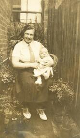
Photograph, Ruby Oke, Ringwood Scouts and Ringwood Guides, with Bob at 5 months
... Lilydale Road, East Ringwood. ...) Oke, who both lived in Old Lilydale Road, East Ringwood. Ruby ...Scanned on 30th January, 2008 from Ida Oke's albums. Ida lives in East Ringwood and also contributed to the East Ringwood Recollections book. Wife of Bob (Robert William) Oke. Both Ida and Bob were heavily involved in the Scout movement, as were Bob's parents - Corrie and Ruby (Guides) Oke, who both lived in Old Lilydale Road, East Ringwood. -
 Ringwood and District Historical Society
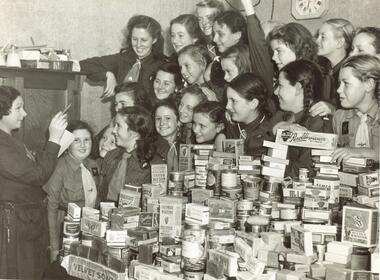
Photograph, Ruby Oke and Ringwood Guides, collecting food for soldiers overseas (Herald)
... Lilydale Road, East Ringwood. ...) Oke, who both lived in Old Lilydale Road, East Ringwood. Ruby ...Scanned on 30th January, 2008 from Ida Oke's albums. Ida lives in East Ringwood and also contributed to the East Ringwood Recollections book. Wife of Bob (Robert William) Oke. Both Ida and Bob were heavily involved in the Scout movement, as were Bob's parents - Corrie and Ruby (Guides) Oke, who both lived in Old Lilydale Road, East Ringwood. -
 Ringwood and District Historical Society
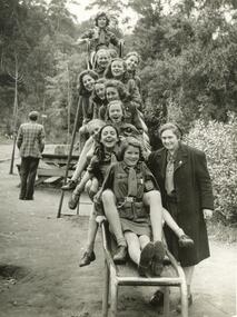
Photograph, Ruby Oke and Ringwood Guides
... Lilydale Road, East Ringwood. ...) Oke, who both lived in Old Lilydale Road, East Ringwood. Ruby ...Scanned on 30th January, 2008 from Ida Oke's albums. Ida lives in East Ringwood and also contributed to the East Ringwood Recollections book. Wife of Bob (Robert William) Oke. Both Ida and Bob were heavily involved in the Scout movement, as were Bob's parents - Corrie and Ruby (Guides) Oke, who both lived in Old Lilydale Road, East Ringwood. -
 Ringwood and District Historical Society
Photograph, Ruby Oke in Guide's uniform, Ringwood identity
... Lilydale Road, East Ringwood. ...) Oke, who both lived in Old Lilydale Road, East Ringwood. Ruby ...Scanned on 30th January, 2008 from Ida Oke's albums. Ida lives in East Ringwood and also contributed to the East Ringwood Recollections book. Wife of Bob (Robert William) Oke. Both Ida and Bob were heavily involved in the Scout movement, as were Bob's parents - Corrie and Ruby (Guides) Oke, who both lived in Old Lilydale Road, East Ringwood. -
 Ringwood and District Historical Society
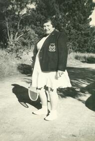
Photograph, Ruby Oke playing tennis, Ringwood identity
... Lilydale Road, East Ringwood. ...) Oke, who both lived in Old Lilydale Road, East Ringwood. Ruby ...Scanned on 30th January, 2008 from Ida Oke's albums. Ida lives in East Ringwood and also contributed to the East Ringwood Recollections book. Wife of Bob (Robert William) Oke. Both Ida and Bob were heavily involved in the Scout movement, as were Bob's parents - Corrie and Ruby (Guides) Oke, who both lived in Old Lilydale Road, East Ringwood. -
 Ringwood and District Historical Society
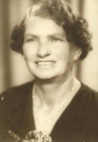
Photograph, Ruby Oke's ( Ringwood Guides identity) mother
... Lilydale Road, East Ringwood. ...) Oke, who both lived in Old Lilydale Road, East Ringwood. Ruby ...Scanned on 30th January, 2008 from Ida Oke's albums. Ida lives in East Ringwood and also contributed to the East Ringwood Recollections book. Wife of Bob (Robert William) Oke. Both Ida and Bob were heavily involved in the Scout movement, as were Bob's parents - Corrie and Ruby (Guides) Oke, who both lived in Old Lilydale Road, East Ringwood. -
 Ringwood and District Historical Society
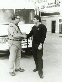
Photograph, Sheen Panels sponsored 3rd Ringwood scout truck, with Bob Oke
... Lilydale Road, East Ringwood. ...) Oke, who both lived in Old Lilydale Road, East Ringwood. Sheen ...Scanned on 30th January, 2008 from Ida Oke's albums. Ida lives in East Ringwood and also contributed to the East Ringwood Recollections book. Wife of Bob (Robert William) Oke. Both Ida and Bob were heavily involved in the Scout movement, as were Bob's parents - Corrie and Ruby (Guides) Oke, who both lived in Old Lilydale Road, East Ringwood. -
 Ringwood and District Historical Society
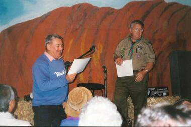
Photograph, Ted Egan and Bob Oke, 3rd Ringwood Scouts identity, at concert in hall
... Lilydale Road, East Ringwood. ...) Oke, who both lived in Old Lilydale Road, East Ringwood. Ted ...Scanned on 30th January, 2008 from Ida Oke's albums. Ida lives in East Ringwood and also contributed to the East Ringwood Recollections book. Wife of Bob (Robert William) Oke. Both Ida and Bob were heavily involved in the Scout movement, as were Bob's parents - Corrie and Ruby (Guides) Oke, who both lived in Old Lilydale Road, East Ringwood. -
 Ringwood and District Historical Society
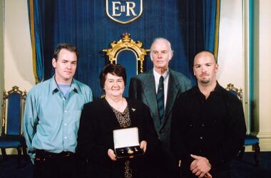
Photograph, Stewart and Ida Oke, Bob Foulkes and Trev Oke at Bob Oke's OA award (Scouts)
... Lilydale Road, East Ringwood. ...) Oke, who both lived in Old Lilydale Road, East Ringwood ...Scanned on 30th January, 2008 from Ida Oke's albums. Ida lives in East Ringwood and also contributed to the East Ringwood Recollections book. Wife of Bob (Robert William) Oke. Both Ida and Bob were heavily involved in the Scout movement, as were Bob's parents - Corrie and Ruby (Guides) Oke, who both lived in Old Lilydale Road, East Ringwood. -
 Ringwood and District Historical Society
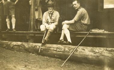
Photograph, Taken by Corrie Oke, of Baden-Powell (BP) and probably Cribbes (Scouts)
... Lilydale Road, East Ringwood. ...) Oke, who both lived in Old Lilydale Road, East Ringwood. Taken ...Scanned on 30th January, 2008 from Ida Oke's albums. Ida lives in East Ringwood and also contributed to the East Ringwood Recollections book. Wife of Bob (Robert William) Oke. Both Ida and Bob were heavily involved in the Scout movement, as were Bob's parents - Corrie and Ruby (Guides) Oke, who both lived in Old Lilydale Road, East Ringwood. -
 Ringwood and District Historical Society
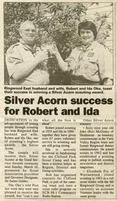
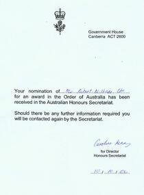
Photograph, Bob and Ida receiving Scouting Acorn awards. In the Ringwood Post on 11 March 1997
... Lilydale Road, East Ringwood. ...) Oke, who both lived in Old Lilydale Road, East Ringwood. Bob ...Scanned on 30th January, 2008 from Ida Oke's albums. Ida lives in East Ringwood and also contributed to the East Ringwood Recollections book. Wife of Bob (Robert William) Oke. Both Ida and Bob were heavily involved in the Scout movement, as were Bob's parents - Corrie and Ruby (Guides) Oke, who both lived in Old Lilydale Road, East Ringwood. -
 Ringwood and District Historical Society
Photograph, Robert William "Bob" Oke Scouting awards (3rd Ringwood)
... Lilydale Road, East Ringwood. ...) Oke, who both lived in Old Lilydale Road, East Ringwood ...Scanned on 30th January, 2008 from Ida Oke's albums. Ida lives in East Ringwood and also contributed to the East Ringwood Recollections book. Wife of Bob (Robert William) Oke. Both Ida and Bob were heavily involved in the Scout movement, as were Bob's parents - Corrie and Ruby (Guides) Oke, who both lived in Old Lilydale Road, East Ringwood. -
 Ringwood and District Historical Society
Photograph, Ida Oke Scouting awards (3rd Ringwood)
... Lilydale Road, East Ringwood. ...) Oke, who both lived in Old Lilydale Road, East Ringwood. Ida ...Scanned on 30th January, 2008 from Ida Oke's albums. Ida lives in East Ringwood and also contributed to the East Ringwood Recollections book. Wife of Bob (Robert William) Oke. Both Ida and Bob were heavily involved in the Scout movement, as were Bob's parents - Corrie and Ruby (Guides) Oke, who both lived in Old Lilydale Road, East Ringwood. -
 Ringwood and District Historical Society
Photograph, Bob Oke OA award and scouting records (3rd Ringwood)
... Lilydale Road, East Ringwood. ...) Oke, who both lived in Old Lilydale Road, East Ringwood. Bob ...Scanned on 30th January, 2008 from Ida Oke's albums. Ida lives in East Ringwood and also contributed to the East Ringwood Recollections book. Wife of Bob (Robert William) Oke. Both Ida and Bob were heavily involved in the Scout movement, as were Bob's parents - Corrie and Ruby (Guides) Oke, who both lived in Old Lilydale Road, East Ringwood. -
 Ringwood and District Historical Society
Photograph, Ruby Oke, Ringwood Guides
... Lilydale Road, East Ringwood. ...) Oke, who both lived in Old Lilydale Road, East Ringwood. Ruby ...Scanned on 30th January, 2008 from Ida Oke's albums. Ida lives in East Ringwood and also contributed to the East Ringwood Recollections book. Wife of Bob (Robert William) Oke. Both Ida and Bob were heavily involved in the Scout movement, as were Bob's parents - Corrie and Ruby (Guides) Oke, who both lived in Old Lilydale Road, East Ringwood. -
 Ringwood and District Historical Society
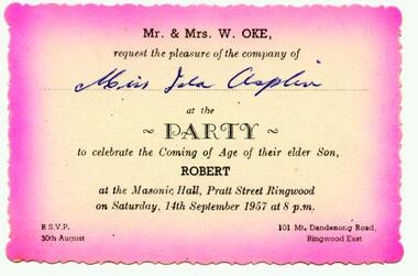
Photograph, Invitation from Mr and Mrs W Oke (101 Mt Dandenong Road, East Ringwood) to celebrate son Robert ("Bob") on his 21st at Ringwood Masonic Hall, Pratt St, Ringwood 1957
... Lilydale Road, East Ringwood. ...) Oke, who both lived in Old Lilydale Road, East Ringwood ...Scanned on 30th January, 2008 from Ida Oke's albums. Ida lives in East Ringwood and also contributed to the East Ringwood Recollections book. Wife of Bob (Robert William) Oke. Both Ida and Bob were heavily involved in the Scout movement, as were Bob's parents - Corrie and Ruby (Guides) Oke, who both lived in Old Lilydale Road, East Ringwood. -
 Ringwood and District Historical Society
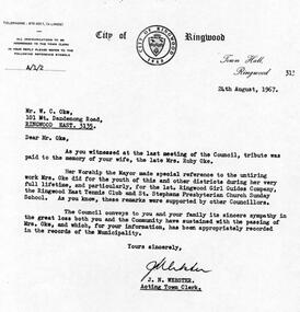
Photograph, Letter from Ringwood Council to change name of street to Oke Street, October 1964
... Lilydale Road, East Ringwood. ...) Oke, who both lived in Old Lilydale Road, East Ringwood ...Scanned on 30th January, 2008 from Ida Oke's albums. Ida lives in East Ringwood and also contributed to the East Ringwood Recollections book. Wife of Bob (Robert William) Oke. Both Ida and Bob were heavily involved in the Scout movement, as were Bob's parents - Corrie and Ruby (Guides) Oke, who both lived in Old Lilydale Road, East Ringwood. -
 Ringwood and District Historical Society
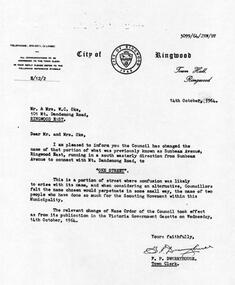
Photograph, Letter from Scouting Australia to Ida and Bob Oke in 2002, suggesting naming of buildings at Clifford Park to "Oke"
... Lilydale Road, East Ringwood. ...) Oke, who both lived in Old Lilydale Road, East Ringwood ...Scanned on 30th January, 2008 from Ida Oke's albums. Ida lives in East Ringwood and also contributed to the East Ringwood Recollections book. Wife of Bob (Robert William) Oke. Both Ida and Bob were heavily involved in the Scout movement, as were Bob's parents - Corrie and Ruby (Guides) Oke, who both lived in Old Lilydale Road, East Ringwood. -
 Ringwood and District Historical Society
Flyer, Executor's Auction Subdivision Advertisement, Lilydale Road and Oban Road, Ringwood East, Vic. - 1937
... Subdivision includes Old Lilydale Road, Joseph Street... Road Ringwood North melbourne Subdivision includes Old Lilydale ...Single page advertisement for Executor's Auction of land in Ringwood East on Saturday, May 29, 1937 with locality map showing 26 building sites for auction highlighted in brown, and brief summary of local services available. Subdivision includes Old Lilydale Road, Joseph Street, Dynes Street, Albert Street (later Wyrunga Street), Carcoola Road, and Mount Dandeong Road. (Carcoola Road incorrectly shown as Oban Road on the subdivision plan). Auctioneer - C.E. Carter, (Phone Ringwood 24. -
 Ringwood and District Historical Society
Flyer, Land Sale Advertisement - Sunbeam Estate, East Ringwood, Victoria - circa 1930
... Avenue, Mount Dandenong Road, and Lilydale Road (later Old..., and Lilydale Road (later Old Lilydale Road). (Agents) Phillips ...Folded double-sided page advertising private sale of 48 residential allotments, with location map, terms of sale, and details of local features and services. Locality plan includes Holland Road, Everard Road, Sunbeam Avenue, Mount Dandenong Road, and Lilydale Road (later Old Lilydale Road). (Agents) Phillips & Nicholson, 59 Swanston Street, Melbourne, (Phone) Central 10907, in conjunction with C.E. Carter, Bank Chambers, Main Street, Ringwood, Telephone Ringwood 24. -
 Ringwood and District Historical Society
Document - Research Notes, Richard Carter, Land Subdivisions in Ringwood 1890-1950
... LP12150 (Circa 1925) Govt Road (now Old Lilydale Road), Sunbeam... LP12150 (Circa 1925) Govt Road (now Old Lilydale Road), Sunbeam ...Handwritten table listing main local pre-1950s subdivisions in the Ringwood area, with estate names, streets, number of allotments for sale, and where known, vendor agent, LP (Lodged Plan) title registration number, and auction/sale date, some with sale price.Pg1 RINGWOOD STATION ESTATE LP3070 (Year?) Station Street, William Street (now Kendall Street), Wantirna Road, Station Street Pg1 RINGWOOD TOWNSHIP ESTATE LP5577 (1913) Station Road (now Warrandyte Road), Pratt Street (part now Aird Street), Whitehorse Road Pg2 RINGWOOD ORCHARD ESTATE LP4315 (1914) Brysons Road, Hillcrest Road, Anzac Avenue, Sulva Road Pg3 RINGWOOD RAILWAY ESTATE LP7522 (1918) Whitehorse Road (now Mount Dandenong Road), Dublin Road, Freeman Street, Patterson Street, Bona Street Pg4 THE RINGWOOD ESTATE LP7578 (1919) Warrandyte Road, Hobart Street, Paxton Street, Arnold Street Pg5 GARDEN FARMS ESTATE (LP?) (1919) Canterbury Road, Armstrong Road, Bungalook Road, Orchard Road, Bayswater Road (now Mountain Highway) Pg6 THE RINGWOOD ESTATE (SECOND SUB-DIVISION) LP7604 (1919) Warrandyte Road, Tamar Street, Derwent Street, Mersey Street Pg7 RINGWOOD STATION ESTATE LP7703 (1919) Bedford Road, Williams Grove (now Lena Grove) Pg8 RINGWOOD TOWNSHIP ESTATE LP8198 (1919) Wantirna Road, Ellison Street, Haig Street, Greenwood Avenue Pg9 EASTFIELD ESTATE (LP?) (1920) Eastfield Road, Longview Road, Pleasant Rise, The Mount Pg10 ELECTRIC RAILWAY ESTATE RINGWOOD LP9473 (1922) Campbell Street, Myrtle Avenue, George Street (now Tudor Court), Henry Street (now Myrtle Avenue), Williams Grove (now Lena Grove) Pg11 RINGWOOD PARK ESTATE LP7884 (1922 - two stages) Wonga Road (now Loughnan Road), William Street, Andrew Street, Harrison Street Pg12 HEATHMONT STATION ESTATE LP11009 (Date? - after 1922) Lisgoold Street, Viviani Crescent, Balrour Avenue, Station Street (now part Heathmont Road and part Wainui Street) Pg13 RINGWOOD RAILWAY ESTATE LP10507 (1923) Whitehorse Road, Sherbrooke Avenue, Burwood Avenue, Bonview Avenue, Heatherbrae Avenue, Grant Crescent Pg14 GARDEN HOMES ESTATE (LP?) (1923) Mullum Road, The Centreway, Wattle Crescent (now Wattle Avenue) Reserve Crescent (now Reserve Road) Pg15 DUBLIN ROAD ESTATE LP11993 (1923) Alexandra Road, Vonadawn Avenue, Green Street, Wood Street, Howard Avenue, Bedford Road, Dublin Road Pg16 CARLINGA ESTATE RINGWOOD LP9620 (1923) Bourke Street, Bond Street, Ringwood Street Pg17 PRATT'S JUNCTION ESTATE (LP?) (1923) Junction Street, Georges Road, Oliver Street, Whitehorse Road Pg18 EAST RINGWOOD ESTATE LP10492 (1923) Bona Street, Patterson Street, Miller Grove, Fairview Avenue, Eastfield Road, Whitehorse Road (now Mount Dandenong Road) Pg19 COLEMAN'S HEATHMONT ESTATE LP9974 (1923) Canterbury Road, Bedford Road, Alvena Crescent, Coleman Street, Leonard Street (now Royal Avenue) Pg20 RINGWOOD HEIGHTS ESTATE LP10506 (1924) Whitehorse Road, Bonview Avenue, Grant Crescent, Hillcrest Avenue, Heatherbrae Avenue, Margaret Street, Mary Street Pg21 EAST RINGWOOD STATION ESTATE LP10551 (1924) Knaith Road, Wenwood Street, Lois Street, Victoria Street, Station Street (now Railway Avenue) Pg22 GRAND VIEW ESTATE LP11019 (1924) Whitehorse Road, Rupert Street, Herbert Street, Leonard Street Pg23 RINGWOOD RAILWAY ESTATE & RINGWOOD HEIGHTS ESTATE - FINAL SECTIONS LP10506 & LP10507 (1924) Whitehorse Road, Sherbrooke Avenue, Burwood Avenue, Bonview Avenue, Heatherbrae Avenue, Margaret Street, Mary Street, Grant Crescent Pg24 RINGWOOD EAST ELECTRIC STATION ESTATE (LP?) (1924) Railway Parade (now Patterrson Street), Federal Road, Howship Avenue (part now French Street), Dublin Road, Rosedale Crescent Pg25 BEDFORD PARK (now Ringwood Secondary College) (LP?) (1924) Bedford Road, Adams Street, Anderson Street, Joyce Street, Graham Road Pg26 CROWN JEWEL ESTATE LP11645 (Private sales after 1924) Mount Dandenong Road, Mirabel Avenue, Valda Avenue, Evon Avenue, Velma Grove Pg27 GRAND CENTRAL ESTATE LP10917 (1925) Heathmont Road, Great Ryrie Street, Douglas Street, Garden Street, Bellevue Avenue Pg28 RINGWOOD (unnamed estate - 1926) Nelson Street, Seymour Street, Whitehorse Road Pg29 EAST RINGWOOD RAILWAY STATION ESTATE (YEAR? - 25 shops 60 villas) Railway Avenue, Dublin Road, Lawrence Grove, Stanley Avenue, Knaith Road Pg30 CHARM VIEW ESTATE (LP?) (year? - after 1926) Canterbury Road, Heathmont Road, Dickasons Road, Bennjett Avenue, Orchid Street Pg31 SUNBEAM ESTATE LP12150 (Circa 1925) Govt Road (now Old Lilydale Road), Sunbeam Avenue, Holland Road, Everard Street (now Everard Road) Pg32 FAIRVIEW ESTATE EAST RINGWOOD LP10853 (Circa 1924) Eastfield Road, Patterson Street, Margaret Street (now Short Street) Pg33 EAST RINGWOOD TOWNSHIP ESTATE LP3025 (Circa 1924 - 35 allotments) Mount Dandenong Road, Grey Street, Eastfield Road Pg34 EAST RINGWOOD TOWNSHIP ESTATE LP3025 (Circa 1924 - 49 allotments) and STATE SCHOOL ESTATE (26 allotments) and EAST RINGWOOD STATION ESTATE (14 shop sites) Mount Dandenong Road, Grety Street, Dunn Street, Eastfield Road, King Street, Holland Road, Dublin Road, Patterson Street, Bona Street Pg35 EAST RINGWOOD CENTRAL ESTATE LP17004 (1948) Knaith Road, Shasta Avenue, Talofa Avenue, Russet Road, Dublin Road Pg36 WARE ESTATE LP43360 (1958) Ware Crescent, Davey Drive, Grey Road (now Grey Street), Mount Dandenong Road Pg37 Lot 57 Kendall Street LP3070 (1939) £75.0.0 Pg37 Lot 14 LP7346 (year?) £225 Pg37 Lot 8 WHITE HORSE ESTATE LP14010 (year?) Maroondah Hwy, Seymour Street £98.9.0 Pg37 Lots 4-14 incl. LP10902 (year?) £300 Pg37 Lots 69&70 LP2216 (1939) Bedford Road, Pitt Street £500 Pg37 Lots 60&70 LP2216 (year?) £460 Pg37 MOUNTAIN VIEW ESTATE LP10902 (1936) Lots 1&2, 19-22 Wantirna Road, Daisy Street £50 Pg38 RAILWAY STATION ESTATE RINGWOOD EAST LP7522 (1925) Lots 16 to 19 £250 Pg38 RINGWOOD PARK ESTATE (LP?) (1924) Lot 112 Munro Street £230 Pg38 RINGWOOD TOWNSHIP ESTATE (LP?) (1925) Lot 57 Wantirna Road £850 Pg38 ELECTRIC RAILWAY ESTATE LP9473 (1925) Lot 98 & 99 £180 (30/- foot) Pg38 ELECTRIC RAILWAY ESTATE LP9473 (year?) Lot 100 £233.12.6 incl improvements (£2.12.6 foot) Pg38 Lot 22&23 Bedford Road Heathmont (LP & year?) £675 incl improvements Pg39 Lot 9 Mullum Mullum Road LP8221 (1923) £150 Pg39 Lot 27 Haig Street LP8198 (1925) £825 Pg39 Lot 56 Haig Street cnr Wantirna Road LP8198 (1923) £171 Pg39 Lots 3 & 4 Loughnan Road LP9626 (192?) £147 Pg39 Lots 98 & 99 Myrtle Avenue LP9473 (1925) £180 Pg39 Lots 80 & 81 Myrtle Avenue LP9473 (1929) £150 Pg39 Lot 30 Sherbrooke Avenue LP10507 (1926) £700 incl improvements Pg40 Lot 10 (year?) LP7703 £750 Pg40 Lot 36 (year?) LP7522 £25 Pg40 Lot 38 Pitt Street LP2216 (year?) £350 Pg40 Lot 7 Dublin Road cnr Green Street LP11993 (year?) £300 -
 Eltham District Historical Society Inc
Album - Photograph Album, J.A. McDonald, Bridge and Road Reconstruction Works, Shire of Eltham, 1952-1962
J.A. McDonald produced this record in the course of his responsibilities as Shire Engineer for Eltham Shire Council.Record of various Shire of Eltham infrastructure works undertaken during the period of 1952-1962 involving bridge and road reconstruction projects, sometimes with Eltham Shire Council Project Reference numbers quoted. It was during this period that a number of significant improvements were made to roads and new bridges constructed within the shire that remain in place as of present day (2022). In many situations, the photos provide a tangible visible record of infrastructure that existed throughout the early days of the Shire. The album was put together by or under the direction of the Shire Engineer, J.A. McDonald.a. gillies, alistair knox park, benchmark studies, bend of islands, blease road, box hill state school, box hill teachers college, box hill tip, bridge construction, bridge street bridge, bridge, brisbane street, brougham steet, bulldozer, cecil street, charis pelling, cherry tree road, city of preston, cr. a. brinkkotter, cr. charis pelling, cranes, cromwell street, diamond creek (creek), diamond street, dixons creek bridge, dixon's creek road, drott, eltham leisure centre, eltham north, eltham police station, eltham, eltham-yarra glen road, f. wood, fitzsimons lane bridge, flat rock road, flood damage, floods, floodwater, footpaths and gutters, ford service garage, g. blair, garden hill, glen park bridge, glenauburn road, grand hotel, haldane road, healesville, healesville-yarra glen road, heidelberg-kinglake road, henley road bridge, henley road, hill property, hurstbridge water scheme, hurstbridge, hurstbridge-arthurs creek road, infrastructure, j. jolly, kangaroo ground, kangaroo ground-queenstown road, kangaroo ground-st andrews road, lilydale shire office, long gully bridge, long gully creek, long gully road, long gully, lower plenty bridge, lower plenty footbridge, lower plenty oval, lower plenty road, lower plenty, main road, methodist church, montmorency, mount pleasant road, new holland, old healesville road, opening ceremony, oxley bridge, para road, paul creek bridge, paul creek road, paul krafeznk, pinnacle lane, plaques, plenty river trail, plenty river, presbyterian church, prof donald thomson, pryor street, railway crossing, railway parade, rattray road, reconstruction works, reichelt avenue, research (vic.), research oval, road construction, rymers corner, shire of eltham, shire of whittlesea, silvan road bridge, silver street bridge, silver street, sir dallas brooks, smedley property, st andrews, steels creek, susan street, tarrawarra, tony carberry, uniting church, upper yarra dam, upper yarra reservoir, w.e. wolf, waterfall property, watsons creek, wattletree road bridge, wattletree road, wattletree road bridge, worlingworth, yarra glen, york street, yow yow creek -
 Eltham District Historical Society Inc
Photograph, Upper Yarra Dam, Spring Tour, 22 Oct 1995, 22/10/1995
EXPLORING THE UPPER YARRA (Newsletter No. 105, November 1995, by Bettina Woodburn) We enjoyed the Spring Excursion, this year "Exploring the Upper Yarra" - in spite of the constant rain and the countryside under the cloud cover, especially in the valleys, being mainly shiny shades of green. The occasional fields of buttercups, clumps of arum lilies and splendid rhododendron and other flowering bushes became very special. The Cobb and Co coach was warm and a cosy retreat as we zig-zagged on the highways and byways to glimpse the Yarra River, upstream and down, its secret places, and particularly the many bridges. Russell excelled as 'Poet Laureate', reading from Dacre Smyth's book. This 1979 publication includes paintings of all the bridges along the river with poems and brief descriptions of each one. Some of the bridges are in out of the way places and are not very well known. We looked forward to hearing the poetry as much as seeing the ' constructions'…Big Pat (was he short or tall, lean or fat? He did win the two hundred pound reward for discovering gold and had the creek named after him), about the 'Eddies'?, and the disliked 'meccano' bridge in Warburton, etc. etc. The hot roast lunch in the old Reefton Hotel was also most welcome. It was easy to imagine it peopled by miners and early settlers. Starting by crossing the new (1974) concrete bridge at Warrandyte we headed through Wonga Park with views to the Christmas Hills and to the escarpment of the Yering Gorge, which causes flood waters to back up through the Yarra Glen plain, so avoiding disasters downstream. At the end of a long driveway we found the wooden, privately owned Henley Bridge (1935 after the 1934 floods). This facilitates access to different parts of Henley Farm and to Lilydale. Everard Park, named after Blanche Shallard's father, a State Member for 17 years, below the Highway Yarra crossing was in need of care. It is 10 miles from Yarra Glen by road but, as "Yarra Marra” canoeists well know, 32 winding miles down by water. After more delightful countryside scenes we joined the Warburton Highway at Woori Yallock. From the old Railway Station at Launching Place the Centennial Trail for walkers, cyclists and ' horse riders has replaced the rails. The line from Lilydale was opened in 1901, and the last diesel freight train ran to Warburton in 1965. It continued to rain as we had morning tea in Warburton in a shelter between footbridges. From here we continued upstream past the Bridge to O'Shannasy Lodge and Reservoir, Starvation Creek, and the Peninsular tunnel (miners dug it as at Pound Bend) which we visited (scrambling down those steps!) on our return after lunch. Our furthermost point was the Upper Yarra Dam Reserve (and vast catchment area). Finished in 1957 after ten years work and 100 years after Yan Yean, it supplies much of Melbourne's water. After crossing the 30m Launching Place Bridge to the Eltham side of the Yarra and Healesville, we saw in the distance the Yarra Glen Timber Trestle Bridge over the river flats "the longest for years in the land it was said!" Harry's dream of "better weather over the Divide" unfortunately didn't come true, but I'm sure we 36 members will retain happy memories of a day that was wet and green and filled with Bridges. Bettina Woodburn - October 1995 Record of the Society's history of activities - Spring 1995 excursionColour photographshire of eltham historical society, activities, upper yarra dam, henley bridge -
 Eltham District Historical Society Inc
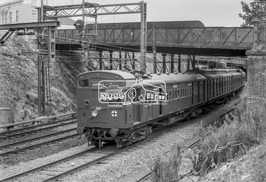
Photograph, George Coop, Elgin Street railway overpass, Hawthorn, c.1962, 1962
Looking southwest towards the Burwood Road overpass on the Camberwell line. GC took this photograph as he liked the laciness of the bridge supports. It is GC's assumption that shortly after the Granville disaster in NSW (18 January 1977) where a train derailment wiped out the bridge supports causing the bridge to collapse and crush the train, that bridges of this kind were replaced to have a single arch bridge structure and that the opportunity was taken when the third line went out the Camberwell, Box Hill, Lilydale lines. There are now three lines there. Back then there used to be the old line coming from Hawthorn to Kew across Barkers Road behind Xavier College and into what is now the VicRoads building in the heart of Kew and a single carriage train like the shuttle service between Eltham and Hurstbridge operated on this line.Digital TIFF file Scan of 35mm Ilford FP3 black and white transparency458m, burwood road, camberwell line, elgin road, hawthorn, lilydale line, overpass, red rattler, tait train, -
 Eltham District Historical Society Inc
Photograph, Upper Yarra Dam, Spring Tour, 22 Oct 1995, 22/10/1995
EXPLORING THE UPPER YARRA (Newsletter No. 105, November 1995, by Bettina Woodburn) We enjoyed the Spring Excursion, this year "Exploring the Upper Yarra" - in spite of the constant rain and the countryside under the cloud cover, especially in the valleys, being mainly shiny shades of green. The occasional fields of buttercups, clumps of arum lilies and splendid rhododendron and other flowering bushes became very special. The Cobb and Co coach was warm and a cosy retreat as we zig-zagged on the highways and byways to glimpse the Yarra River, upstream and down, its secret places, and particularly the many bridges. Russell excelled as 'Poet Laureate', reading from Dacre Smyth's book. This 1979 publication includes paintings of all the bridges along the river with poems and brief descriptions of each one. Some of the bridges are in out of the way places and are not very well known. We looked forward to hearing the poetry as much as seeing the ' constructions'…Big Pat (was he short or tall, lean or fat? He did win the two hundred pound reward for discovering gold and had the creek named after him), about the 'Eddies'?, and the disliked 'meccano' bridge in Warburton, etc. etc. The hot roast lunch in the old Reefton Hotel was also most welcome. It was easy to imagine it peopled by miners and early settlers. Starting by crossing the new (1974) concrete bridge at Warrandyte we headed through Wonga Park with views to the Christmas Hills and to the escarpment of the Yering Gorge, which causes flood waters to back up through the Yarra Glen plain, so avoiding disasters downstream. At the end of a long driveway we found the wooden, privately owned Henley Bridge (1935 after the 1934 floods). This facilitates access to different parts of Henley Farm and to Lilydale. Everard Park, named after Blanche Shallard's father, a State Member for 17 years, below the Highway Yarra crossing was in need of care. It is 10 miles from Yarra Glen by road but, as "Yarra Marra” canoeists well know, 32 winding miles down by water. After more delightful countryside scenes we joined the Warburton Highway at Woori Yallock. From the old Railway Station at Launching Place the Centennial Trail for walkers, cyclists and ' horse riders has replaced the rails. The line from Lilydale was opened in 1901, and the last diesel freight train ran to Warburton in 1965. It continued to rain as we had morning tea in Warburton in a shelter between footbridges. From here we continued upstream past the Bridge to O'Shannasy Lodge and Reservoir, Starvation Creek, and the Peninsular tunnel (miners dug it as at Pound Bend) which we visited (scrambling down those steps!) on our return after lunch. Our furthermost point was the Upper Yarra Dam Reserve (and vast catchment area). Finished in 1957 after ten years work and 100 years after Yan Yean, it supplies much of Melbourne's water. After crossing the 30m Launching Place Bridge to the Eltham side of the Yarra and Healesville, we saw in the distance the Yarra Glen Timber Trestle Bridge over the river flats "the longest for years in the land it was said!" Harry's dream of "better weather over the Divide" unfortunately didn't come true, but I'm sure we 36 members will retain happy memories of a day that was wet and green and filled with Bridges. Bettina Woodburn - October 1995 Record of the Society's history of activities - Spring 1995 excursionRoll of 35mm colour negative film, 3 stripsKodak Gold 200-4shire of eltham historical society, activities, upper yarra dam, henley bridge -
 Eltham District Historical Society Inc
Photograph, Upper Yarra Dam, Spring Tour, 22 Oct 1995, 22/10/1995
EXPLORING THE UPPER YARRA (Newsletter No. 105, November 1995, by Bettina Woodburn) We enjoyed the Spring Excursion, this year "Exploring the Upper Yarra" - in spite of the constant rain and the countryside under the cloud cover, especially in the valleys, being mainly shiny shades of green. The occasional fields of buttercups, clumps of arum lilies and splendid rhododendron and other flowering bushes became very special. The Cobb and Co coach was warm and a cosy retreat as we zig-zagged on the highways and byways to glimpse the Yarra River, upstream and down, its secret places, and particularly the many bridges. Russell excelled as 'Poet Laureate', reading from Dacre Smyth's book. This 1979 publication includes paintings of all the bridges along the river with poems and brief descriptions of each one. Some of the bridges are in out of the way places and are not very well known. We looked forward to hearing the poetry as much as seeing the ' constructions'…Big Pat (was he short or tall, lean or fat? He did win the two hundred pound reward for discovering gold and had the creek named after him), about the 'Eddies'?, and the disliked 'meccano' bridge in Warburton, etc. etc. The hot roast lunch in the old Reefton Hotel was also most welcome. It was easy to imagine it peopled by miners and early settlers. Starting by crossing the new (1974) concrete bridge at Warrandyte we headed through Wonga Park with views to the Christmas Hills and to the escarpment of the Yering Gorge, which causes flood waters to back up through the Yarra Glen plain, so avoiding disasters downstream. At the end of a long driveway we found the wooden, privately owned Henley Bridge (1935 after the 1934 floods). This facilitates access to different parts of Henley Farm and to Lilydale. Everard Park, named after Blanche Shallard's father, a State Member for 17 years, below the Highway Yarra crossing was in need of care. It is 10 miles from Yarra Glen by road but, as "Yarra Marra” canoeists well know, 32 winding miles down by water. After more delightful countryside scenes we joined the Warburton Highway at Woori Yallock. From the old Railway Station at Launching Place the Centennial Trail for walkers, cyclists and ' horse riders has replaced the rails. The line from Lilydale was opened in 1901, and the last diesel freight train ran to Warburton in 1965. It continued to rain as we had morning tea in Warburton in a shelter between footbridges. From here we continued upstream past the Bridge to O'Shannasy Lodge and Reservoir, Starvation Creek, and the Peninsular tunnel (miners dug it as at Pound Bend) which we visited (scrambling down those steps!) on our return after lunch. Our furthermost point was the Upper Yarra Dam Reserve (and vast catchment area). Finished in 1957 after ten years work and 100 years after Yan Yean, it supplies much of Melbourne's water. After crossing the 30m Launching Place Bridge to the Eltham side of the Yarra and Healesville, we saw in the distance the Yarra Glen Timber Trestle Bridge over the river flats "the longest for years in the land it was said!" Harry's dream of "better weather over the Divide" unfortunately didn't come true, but I'm sure we 36 members will retain happy memories of a day that was wet and green and filled with Bridges. Bettina Woodburn - October 1995 Record of the Society's history of activities - Spring 1995 excursionRoll of 35mm colour negative film, 3 stripsKodak Gold 200-4shire of eltham historical society, activities, upper yarra dam, henley bridge