Showing 42 items
matching orchard avenue
-
 Park Orchards Community House
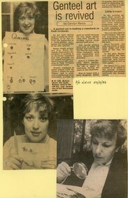
Photograph, Quilling class at the Park Orchards Community House with Robyn Floyd of Euston Avenue, Park Orchards. Doncaster-Templestowe News on 28 February 1984
... House with Robyn Floyd of Euston Avenue, Park Orchards ...Unknown year -
 Park Orchards Community House
Photograph, Park Orchards, corner of Park Road and Enfield Avenue
-
 Bacchus Marsh & District Historical Society
Photograph, Osage Orange Avenue Taverner Street Bacchus Marsh
A.C. (Arthur Charles) Simon a pioneer orchardist in the Bacchus Marsh district planted this avenue of Osage orange trees in about 1883, creating an imposing entrance to his property from Taverner Street. Simon also believed that the trees on his orchard property would provide a protective shelter for his other plants. Osage orange trees (Maclura pomifera) are a small deciduous tree or large shrub, native to the south-central United States. It usually grows to about 8 to 15 metres high. The distinctive fruit, a multiple fruit that resembles an immature orange, is roughly spherical in shape, about 8 to 15 centimetres in diameter, and turns bright yellow-green in the autumn. A. C. Simon is believed to have imported the Osage orange seeds from America around the 1860s and later used them to plant the trees depicted in this image. The date of this image is not certain but it probably shows the trees around the 1900s or 1910s. The avenue of trees was known for many years in Bacchus Mars as 'Simons Avenue', and were featured in a Rose series postcard dating from around 1900-1920. The remnants of this avenue or grove of trees can be seen on some of the properties on the north side of Taverner Street Bacchus Marsh and along the Werribee River west of the FIsken Street bridge.The Bacchus Marsh Heritage Study of 1995 described the Osage Orange Tree avenue as being of regional historical significance as a landscaping practice, pioneering of its type, It was also described as of local significance as a well-known landmark due to it be being represented on widely distributed post cards which depicted scenes of Bacchus Marsh in the early part of the twentieth century. This early photographic image is evidence of this social and cultural significance.A black and white photograph print mounted on mounting board showing an avenue of Osage orange trees. trees, osage orange trees, simon family bacchus marsh, arthur charles simon 1833-1924, orchardists -
 Eltham District Historical Society Inc
Photograph - Digital Photograph, Alan King, Golden King Mine poppet-head, Yarrambat Primary School, 1 February 2008
The Golden King Mine poppet-head stands at the school’s Yan Yean Road exit gate. Published: Nillumbik Now and Then / Marguerite Marshall 2008; photographs Alan King with Marguerite Marshall.; p23 Early Yarambat - Tanck's Corner Its early settlers, who in the 1840s were amongst the first non-Aboriginal people in the area, found life tough as they grazed their sheep and cattle. Yarrambat was then known as Tanck’s Corner or Reynolds Corner, after wood carter, Frederick Tanck, who owned land north of Ironbark Road, at the corner of Yan Yean Road, and Thomas Reynolds, owner of the opposite property. After Reynolds sold his land, the corner became known as Tanck’s Corner. In 1929 the district’s name was changed to Yarrambat, believed to mean ‘high hill’ in the Wurundjeri language. Tanck’s Corner was in the centre of gold-bearing country and the district is honeycombed with old tunnels and shafts. However although gold played a dominant role for decades, there was insufficient to develop a substantial township. Meat and agricultural produce made a greater impact. Until the mid-20th century the only substantial building was the primary school. The first gold rush occurred around 1860, the second after 1900; then during the Depression, the Government paid men to pan for gold. The first rush attracted hundreds of Chinese people to Smugglers Gully, who constructed round diggings to keep away spirits. Alluvial miners lived along the Plenty River in tents or humpies - some fenced with gardens - and some miners distilled their own ‘plonk’. It was a wild time and bushrangers - and later gangster Squizzy Taylor - were said to hide4 in the old Pioneer Tunnel in Dunne’s Gully between Heard Avenue and Pioneer Road. Mines opposite Tanck’s Corner included Beer’s Line, Golden Crown and Golden Stairs. Some of the big mines had batteries and stampers to process quartz. At first there was plenty of alluvial gold, as much as two ounces to the ton. At times gold was exposed after heavy rains so fossickers panned for gold around orchard irrigation trenches. Gold was mined until 1984 when Yarrambat’s last operating goldmine, the Golden King Mine, in North Oatlands Road, closed. The Clayton family operated it full-time, making a comfortable living and in the 1960s it was the only private family gold mine in Victoria.5 Gold was such an important part of Yarrambat’s history that a gold poppet-head is the Yarrambat Primary School’s logo. The Golden King Mine poppet-head stands at the school’s Yan Yean Road exit gate. However this school was built in 1988. The original school No 2054, at the corner of Ironbark and Yan Yean Roads, was opened in 1878 and modified to its present form in the 1920s. In 2000 it was relocated to the Heritage Museum at Yarrambat Park.7 The school, whose first head teacher was Charles Planner, consisted of one room with a three-roomed residence. The school was also the community centre. On Saturday nights it was crammed for dances or euchre parties, community singing or other social events. On Sundays, services for different denominations took turns each week. However the school had its teething problems. Parents accused Charles Planner of neglecting his duties and the school closed several times. When it closed in 1892, only church services continued. Social activities moved elsewhere, such as the tennis club to the Stuchbery tennis court opposite. A sports day and woodchop on Boxing Day around 1900 was held at the Evelyn Hill Hotel, also called Evelyn Arms and Tunnel Hill Hotel, on the Greensborough–Diamond Creek Road. An annual agricultural show in Diamond Creek paraded through the town, and New Year’s Day picnics at the Yan Yean Reservoir included highland dancing and competitions. Also popular were the Indian hawkers who visited every three months, selling trinkets, clothing and other items. One called Jimmy ‘Allem dem Bedi’, gave presents and told stories, played draughts and sold delicious curries he cooked over his camp fire at night.This collection of almost 130 photos about places and people within the Shire of Nillumbik, an urban and rural municipality in Melbourne's north, contributes to an understanding of the history of the Shire. Published in 2008 immediately prior to the Black Saturday bushfires of February 7, 2009, it documents sites that were impacted, and in some cases destroyed by the fires. It includes photographs taken especially for the publication, creating a unique time capsule representing the Shire in the early 21st century. It remains the most recent comprehenesive publication devoted to the Shire's history connecting local residents to the past. nillumbik now and then (marshall-king) collection, golden king mine, tanck's corner, yarrambat primary school -
 Eltham District Historical Society Inc
Photograph - Digital Photograph, Alan King, Ellis Cottage, Diamond Creek, 23 January 2008
Built by William Ellis in 1865 of local uncut stone about 30cm thick, the cottage is now a museum and home to the Nillumbik Historical Society. Ellis Cottage is historically significant for its association with the Ellis family, who were pioneers of the Diamond Creek district and the benefactors of the notable Nillumbik Cemetery gateway. It illustrates the development of farming in the area. Ellis Cottage is historically and technically significant for its rare use of uncut local stone for building purposes. Covered under Heritage Overlay, Nillumbik Planning Scheme. National Estate Published: Nillumbik Now and Then / Marguerite Marshall 2008; photographs Alan King with Marguerite Marshall.; p79 Ellis Cottage, built by William Ellis, is a memorial to the courage of pioneers in the Diamond Valley area.1 Now a museum and home to the Nillumbik Historical Society, it is a fine example of an early settler’s house in Diamond Creek – and one of the few original buildings standing from the middle of the 19th century. It is a poor man’s cottage – typical of the dwellings of those who had to work hard to wrest a living in this district, because most of the land was not fertile enough for major forms of farming. The pretty stone cottage at 10 Nillumbik Square, built in 1865, is made of local uncut stone about one foot (30 cm) thick. It once stood near the centre of the 147 acres (59.4ha) Ellis bought in 1850. The property extended from Diamond Creek to Reynolds Road and from Perversi Avenue to the Wattle Glen School. It stood in the electoral parish of Nillumbik. The Nillumbik township (later called Diamond Creek) was not created until 1867. In 1912 the property was cut in half by the new railway to Hurstbridge. Ellis paid £147/10/- for the land - about three times what a Victorian farmer would usually earn in a year. Despite the poor quality soil Ellis became a very successful farmer with an orchard, vegetables and a dairy herd. Five years later, in 1855, Ellis bought 70 acres (28.3ha) from neighbour, Hugh Larimour. In 1857 Ellis bought 208 acres (84ha) at Yarra Glen. In 1877 he bought 122 acres (49.3ha) at Diamond Creek and later bought land at Greensborough and Woodstock. Ellis was born in 1815 at Blackawton, a small Devonshire village, and became a tenant farmer. It is not known why Ellis came out to Australia or settled in Diamond Creek. In 1847 he married Margaret Child at the Melbourne Presbyterian Church. Ellis and Child had no children and 18 years after the wedding, while probably living in Kangaroo Ground, Ellis built this small cottage. The simple cottage has a central hall and two rooms on each side. To maximise the small space the ceiling cavity was designed large enough to provide sleeping accommodation accessed via a ladder. Each room was heated by an open fireplace and the one in the kitchen was large enough to roast a sheep. A large cellar under the front room probably stored farm produce. Water came from a well as reticulated water did not arrive at Diamond Creek until 1914. In 1870 Ellis’ 22 year-old nephew Nathaniel joined him from England.2 Until 1890 they developed Ellis Park, praised in The Evelyn Observer, May 30,1890 as a model farm. Ellis had become wealthy, and on his death in 1896 his estate was valued at £9000. In his will he left £100 to construct memorial gates at the Nillumbik Cemetery where he was buried.3 Ellis left the farm to his second wife Louisa. As he had no children, upon her death the farm passed to Nathaniel, but he did not take it up. The farm was sold and leased several times until 1967, when engineer Phillip Lovitt bought the property and carried out major structural works. The Shire of Diamond Valley bought it in the 1980s and in 1989 restored it with the Nillumbik Historical Society. The stone walls of the cottage had been plastered with mud and straw mortar, which were removed as they were riddled with vermin. Doors, windows and a floor were replaced and the original roof of timber shingles had been replaced with slate. The well was too deeply cracked to be restored, so was used for a flower bed. Two mature Italian Cypresses at the entry are also heritage protected as they relate to similar trees planted at Shillinglaw Cottage and other early buildings in Nillumbik Shire.This collection of almost 130 photos about places and people within the Shire of Nillumbik, an urban and rural municipality in Melbourne's north, contributes to an understanding of the history of the Shire. Published in 2008 immediately prior to the Black Saturday bushfires of February 7, 2009, it documents sites that were impacted, and in some cases destroyed by the fires. It includes photographs taken especially for the publication, creating a unique time capsule representing the Shire in the early 21st century. It remains the most recent comprehenesive publication devoted to the Shire's history connecting local residents to the past. nillumbik now and then (marshall-king) collection, ellis cottage, diamond creek, nillumbik historical society, william ellis -
 Ringwood and District Historical Society
Document - Department of Lands and Survey, Wire Netting Branch, Melbourne, Victoria, Application for Vermin-Proof Fence Certificate - L.J. Mills vs John Collins, Grandview Grove, Ringwood, Victoria - 1939
Photocopied file of corresponence and documentation relating to a claim by L.J. Mills, Nurseryman, that adjoining property owner, J. Collins, Farmer, assists with replacement of a vermin proof wire netting dividing fence destroyed by 1939 bushfire. File includes 1939 and 1940 detailed property inspection reports by Vermin and Noxious Weeds Branch, Lands Department, Lilydale, describing land use in the area and signs of vermin activity. Application approved 18th April, 1940. Appeal lodged by Mr Collins disallowed in May, 1940. File closed June, 1940 with Departmental suggesion that Mr Mills consider further legal action through a Solicitor as fence had still not been wire-netted. TRANSCRIPTS: Vermin & Noxious Weeds Inspection Reports "19/9/1939 (To) Superintendent (Department of Lands and Survey, Melbourne) Re L.J. Mills application for Vermin Proof Fence. I called on Mr Mills yesterday 18th instant in connection with this matter. Mr Mills has a flower farm and claims that rabbits and hares are damaging his flowers. He showed me a bed of carnations which he stated were being damaged by rabbits. There was evidence of some leaves being nipped off, but I am unable to say whether this is due to rabbits or grubs. Very little if any real damage is being done. The property is netted on the east and south boundary and on half the north and west boundary. The surrounding country is undlating and fairly steep in places. The land to the east across Grandview Avenue (sic) is all planted out in old established orchards and well cultivated. Cleared grass land adjoins the south boundary and bush land adjoins the north and west boundaries. I walked over a large area surrounding Mr Mills land and never saw any rabbits or hares or any indications of rabbits. This locality is not rabbit infested and very little wire netting is being used. I do not consider that a vermin proof fence is necessary between these allotments. - Jas H Allison (Inspector, Vermin and Noxious Weeds Branch, Lands Department, Lilydale)." Follow up report following renewal of application for Certificate by Mr Mills, citing rabbits causing considerable damage to his flowers. He laid poison and obtained 9 carcases and stated that there is evidence of rabbit infestation from the adjoing land. "19/3/1940 (To) Mr Hannah (Superintendant, Department of Lands and Survey, Melbourne) Re L.J. Mills, Grandview Grove Ringwood, Lot 4 Grandview Estate Pt CG20 Ph of Warrandyte. I interviewed Mr Mills at his home on 15th inst. He showed me carcases of rabbits which he stated had been poisoned on his land. In places young plants had been nipped off apparently by rabbits. I made an inspection of adjoining properties and found one live burrow close to Mr Mills northern boundary. There were scratches and other evidence of rabbits on land north and west of Mr Mills property. In view of the present evidence of rabbits I consider that a vermin proof fence is now necessary to protect the flowers grown by Mr Mills. His land is netted on whole of east and south boundary and half way on west and north boundary. The adjoining land on west and north boundaries is owned by Mrs Linda Collins and John Collins resp of Brysons Road East Ringwood. - Jas H Allison (Inspector, Vermin and Noxious Weeds Branch, Lands Department, Lilydale)." -
 Ringwood and District Historical Society
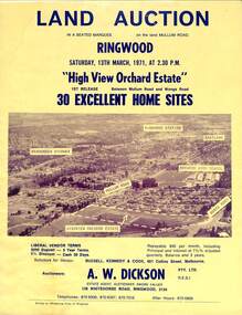
Flyer, Land Auction Sale Brochure, High View Orchard Estate, Ringwood, Vic. - 1971
Double-sided advertisement for Ringwood High View Orchard Estate land auction sale on Saturday, 13th March, 1971, including aerial photograph, map, and summary of local facilities and services.Subdivision includes Wonga Road, Oban Road, Sang Court, Ambrie Avenue, Hendra Grove, and Mullum Mullum Road. Agent - A.W. Dickson Pty. Ltd., 136 Whitehorse Road, Ringwood, 3134. Telephones: 870 6000, 870 6007, 870 7016, after hours 870 6868. A separate copy of the advertisement includes a local newspaper follow-up clipping reports thirty home sites grossing $102,350 at the auction. -
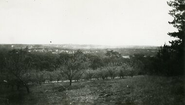 Ringwood and District Historical Society
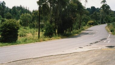
Photograph, Looking from Royal Avenue, Heathmont towards Heathmont Road. This was the westerly end Herman Pump orchard
-
 Ringwood and District Historical Society
Document - Research Notes, Richard Carter, Land Subdivisions in Ringwood 1890-1950
Handwritten table listing main local pre-1950s subdivisions in the Ringwood area, with estate names, streets, number of allotments for sale, and where known, vendor agent, LP (Lodged Plan) title registration number, and auction/sale date, some with sale price.Pg1 RINGWOOD STATION ESTATE LP3070 (Year?) Station Street, William Street (now Kendall Street), Wantirna Road, Station Street Pg1 RINGWOOD TOWNSHIP ESTATE LP5577 (1913) Station Road (now Warrandyte Road), Pratt Street (part now Aird Street), Whitehorse Road Pg2 RINGWOOD ORCHARD ESTATE LP4315 (1914) Brysons Road, Hillcrest Road, Anzac Avenue, Sulva Road Pg3 RINGWOOD RAILWAY ESTATE LP7522 (1918) Whitehorse Road (now Mount Dandenong Road), Dublin Road, Freeman Street, Patterson Street, Bona Street Pg4 THE RINGWOOD ESTATE LP7578 (1919) Warrandyte Road, Hobart Street, Paxton Street, Arnold Street Pg5 GARDEN FARMS ESTATE (LP?) (1919) Canterbury Road, Armstrong Road, Bungalook Road, Orchard Road, Bayswater Road (now Mountain Highway) Pg6 THE RINGWOOD ESTATE (SECOND SUB-DIVISION) LP7604 (1919) Warrandyte Road, Tamar Street, Derwent Street, Mersey Street Pg7 RINGWOOD STATION ESTATE LP7703 (1919) Bedford Road, Williams Grove (now Lena Grove) Pg8 RINGWOOD TOWNSHIP ESTATE LP8198 (1919) Wantirna Road, Ellison Street, Haig Street, Greenwood Avenue Pg9 EASTFIELD ESTATE (LP?) (1920) Eastfield Road, Longview Road, Pleasant Rise, The Mount Pg10 ELECTRIC RAILWAY ESTATE RINGWOOD LP9473 (1922) Campbell Street, Myrtle Avenue, George Street (now Tudor Court), Henry Street (now Myrtle Avenue), Williams Grove (now Lena Grove) Pg11 RINGWOOD PARK ESTATE LP7884 (1922 - two stages) Wonga Road (now Loughnan Road), William Street, Andrew Street, Harrison Street Pg12 HEATHMONT STATION ESTATE LP11009 (Date? - after 1922) Lisgoold Street, Viviani Crescent, Balrour Avenue, Station Street (now part Heathmont Road and part Wainui Street) Pg13 RINGWOOD RAILWAY ESTATE LP10507 (1923) Whitehorse Road, Sherbrooke Avenue, Burwood Avenue, Bonview Avenue, Heatherbrae Avenue, Grant Crescent Pg14 GARDEN HOMES ESTATE (LP?) (1923) Mullum Road, The Centreway, Wattle Crescent (now Wattle Avenue) Reserve Crescent (now Reserve Road) Pg15 DUBLIN ROAD ESTATE LP11993 (1923) Alexandra Road, Vonadawn Avenue, Green Street, Wood Street, Howard Avenue, Bedford Road, Dublin Road Pg16 CARLINGA ESTATE RINGWOOD LP9620 (1923) Bourke Street, Bond Street, Ringwood Street Pg17 PRATT'S JUNCTION ESTATE (LP?) (1923) Junction Street, Georges Road, Oliver Street, Whitehorse Road Pg18 EAST RINGWOOD ESTATE LP10492 (1923) Bona Street, Patterson Street, Miller Grove, Fairview Avenue, Eastfield Road, Whitehorse Road (now Mount Dandenong Road) Pg19 COLEMAN'S HEATHMONT ESTATE LP9974 (1923) Canterbury Road, Bedford Road, Alvena Crescent, Coleman Street, Leonard Street (now Royal Avenue) Pg20 RINGWOOD HEIGHTS ESTATE LP10506 (1924) Whitehorse Road, Bonview Avenue, Grant Crescent, Hillcrest Avenue, Heatherbrae Avenue, Margaret Street, Mary Street Pg21 EAST RINGWOOD STATION ESTATE LP10551 (1924) Knaith Road, Wenwood Street, Lois Street, Victoria Street, Station Street (now Railway Avenue) Pg22 GRAND VIEW ESTATE LP11019 (1924) Whitehorse Road, Rupert Street, Herbert Street, Leonard Street Pg23 RINGWOOD RAILWAY ESTATE & RINGWOOD HEIGHTS ESTATE - FINAL SECTIONS LP10506 & LP10507 (1924) Whitehorse Road, Sherbrooke Avenue, Burwood Avenue, Bonview Avenue, Heatherbrae Avenue, Margaret Street, Mary Street, Grant Crescent Pg24 RINGWOOD EAST ELECTRIC STATION ESTATE (LP?) (1924) Railway Parade (now Patterrson Street), Federal Road, Howship Avenue (part now French Street), Dublin Road, Rosedale Crescent Pg25 BEDFORD PARK (now Ringwood Secondary College) (LP?) (1924) Bedford Road, Adams Street, Anderson Street, Joyce Street, Graham Road Pg26 CROWN JEWEL ESTATE LP11645 (Private sales after 1924) Mount Dandenong Road, Mirabel Avenue, Valda Avenue, Evon Avenue, Velma Grove Pg27 GRAND CENTRAL ESTATE LP10917 (1925) Heathmont Road, Great Ryrie Street, Douglas Street, Garden Street, Bellevue Avenue Pg28 RINGWOOD (unnamed estate - 1926) Nelson Street, Seymour Street, Whitehorse Road Pg29 EAST RINGWOOD RAILWAY STATION ESTATE (YEAR? - 25 shops 60 villas) Railway Avenue, Dublin Road, Lawrence Grove, Stanley Avenue, Knaith Road Pg30 CHARM VIEW ESTATE (LP?) (year? - after 1926) Canterbury Road, Heathmont Road, Dickasons Road, Bennjett Avenue, Orchid Street Pg31 SUNBEAM ESTATE LP12150 (Circa 1925) Govt Road (now Old Lilydale Road), Sunbeam Avenue, Holland Road, Everard Street (now Everard Road) Pg32 FAIRVIEW ESTATE EAST RINGWOOD LP10853 (Circa 1924) Eastfield Road, Patterson Street, Margaret Street (now Short Street) Pg33 EAST RINGWOOD TOWNSHIP ESTATE LP3025 (Circa 1924 - 35 allotments) Mount Dandenong Road, Grey Street, Eastfield Road Pg34 EAST RINGWOOD TOWNSHIP ESTATE LP3025 (Circa 1924 - 49 allotments) and STATE SCHOOL ESTATE (26 allotments) and EAST RINGWOOD STATION ESTATE (14 shop sites) Mount Dandenong Road, Grety Street, Dunn Street, Eastfield Road, King Street, Holland Road, Dublin Road, Patterson Street, Bona Street Pg35 EAST RINGWOOD CENTRAL ESTATE LP17004 (1948) Knaith Road, Shasta Avenue, Talofa Avenue, Russet Road, Dublin Road Pg36 WARE ESTATE LP43360 (1958) Ware Crescent, Davey Drive, Grey Road (now Grey Street), Mount Dandenong Road Pg37 Lot 57 Kendall Street LP3070 (1939) £75.0.0 Pg37 Lot 14 LP7346 (year?) £225 Pg37 Lot 8 WHITE HORSE ESTATE LP14010 (year?) Maroondah Hwy, Seymour Street £98.9.0 Pg37 Lots 4-14 incl. LP10902 (year?) £300 Pg37 Lots 69&70 LP2216 (1939) Bedford Road, Pitt Street £500 Pg37 Lots 60&70 LP2216 (year?) £460 Pg37 MOUNTAIN VIEW ESTATE LP10902 (1936) Lots 1&2, 19-22 Wantirna Road, Daisy Street £50 Pg38 RAILWAY STATION ESTATE RINGWOOD EAST LP7522 (1925) Lots 16 to 19 £250 Pg38 RINGWOOD PARK ESTATE (LP?) (1924) Lot 112 Munro Street £230 Pg38 RINGWOOD TOWNSHIP ESTATE (LP?) (1925) Lot 57 Wantirna Road £850 Pg38 ELECTRIC RAILWAY ESTATE LP9473 (1925) Lot 98 & 99 £180 (30/- foot) Pg38 ELECTRIC RAILWAY ESTATE LP9473 (year?) Lot 100 £233.12.6 incl improvements (£2.12.6 foot) Pg38 Lot 22&23 Bedford Road Heathmont (LP & year?) £675 incl improvements Pg39 Lot 9 Mullum Mullum Road LP8221 (1923) £150 Pg39 Lot 27 Haig Street LP8198 (1925) £825 Pg39 Lot 56 Haig Street cnr Wantirna Road LP8198 (1923) £171 Pg39 Lots 3 & 4 Loughnan Road LP9626 (192?) £147 Pg39 Lots 98 & 99 Myrtle Avenue LP9473 (1925) £180 Pg39 Lots 80 & 81 Myrtle Avenue LP9473 (1929) £150 Pg39 Lot 30 Sherbrooke Avenue LP10507 (1926) £700 incl improvements Pg40 Lot 10 (year?) LP7703 £750 Pg40 Lot 36 (year?) LP7522 £25 Pg40 Lot 38 Pitt Street LP2216 (year?) £350 Pg40 Lot 7 Dublin Road cnr Green Street LP11993 (year?) £300 -
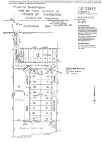 Ringwood and District Historical Society
Document - Subdivision Plan, LP23855 Part of Crown Allotment 14B, Parish of Ringwood, County of Mornington, Vol 6687 Fol 394 - 1952
... Map includes Cuthbert Street, Orchard Grove, and Lowen...Map includes Cuthbert Street, Orchard Grove, and Lowen ...LANDATA Land Victoria plan printout circa 2008Map includes Cuthbert Street, Orchard Grove, and Lowen Avenue (formerly part of Balfour Avenue), Heathmont. Other markings include SP25736, LP98835 and LP40209. -
 Ringwood and District Historical Society
Document - Subdivision Map, Part of Crown Sections 18, 19, 24 & 25, Parish of Warrandyte, County of Evelyn, Vol 5228 Fol 472 - 1926. (Park Orchards, Victoria)
A3 and A4 sized photocopies showing map section of land title showing streets, easements and allotment numbers, some with handwritten names and pricing notations circa mid 1950s.Map includes Valley Road, Granard Avenue, Park Road, Arundel Avenue, Hylton Avenue, Aviemore Avenue, Bowmore Avenue, Hopetoun Road, Colin Avenue, Daintree Avenue, Brucedale Crescent, Feversham Avenue, Ennismore Crescent, Iona Grove, Elgin Crescent and Gosford Crescent, Park Orchards, Victoria. -
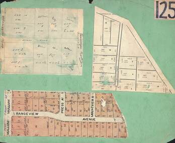 Ringwood and District Historical Society
Card, Collage of Residential Subdivision Map Clippings - Ringwood, Victoria - (Undated)
Three maps mounted on green cardboard - Hand-drawn map of residential allotments off Warrandyte Road in Milne Road and Berringa Road Park Orchards. Map with acres roods and perches measurements of allotments in Canterbury Road and Miller Street Heathmont. Clipping from a land sale brochure with street names not existing together in the area - Rangeview Avenue, Press Avenue and Mountview Avenue.