Showing 347 items
matching panoramic
-
 Bendigo Military Museum
Map, 11 April 1917
Panoramic sketch by George W Bleach A 2nd Anzac Topographical Section. April 11th 1917. View from Heath Trench. Co-ords of O.P.U13.b 30.20Panoramic view of Messines. Printed on cream card. Sepia image. By George W Bleach A 2nd Anzac Topographical Section. April 11th 1917. George W Bleach A 2nd Anzac Topographical Section. April 11th 1917.panoramic view of messines -
 Lakes Entrance Regional Historical Society (operating as Lakes Entrance History Centre & Museum)
Postcard, 1920 c
Also panoramic postcard view from southern part of Rigby Island to Lakes Entrance township 04336.1, 5 x 30 cmBlack and white panoramic folding postcard of the Gippsland Lakes including Reeves Channel, Rigby Island, the entrance, Bullock Island and Lakes Entrance township taken from Jemmys Point Lakes Entrance Victoriaaccommodation, guesthouses -
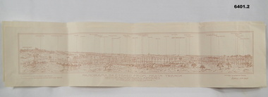
 Stawell Historical Society Inc
Drawing, Town & Big Hill from King Street area -- Sketch
Town & Big Hill from King Street areaBlack and White sketch drawn from King Street area St Patrick's church just right of centre. Poppet heads on skyline. A Panoramic View of Stawellstawell -
 Kew Historical Society Inc
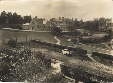
Photograph, Burke Hall, Xavier Preparatory School, circa 1930, c. 1930
This work forms part of the collection assembled by the historian Dorothy Rogers, that was donated to the Kew Historical Society by her son John Rogers in 2015. The manuscripts, photographs, maps, and documents were sourced by her from both family and local collections or produced as references for her print publications. Many were directly used by Rogers in writing ‘Lovely Old Homes of Kew’ (1961) and 'A History of Kew' (1973), or the numerous articles on local history that she produced for suburban newspapers. Most of the photographs in the collection include detailed annotations in her hand. The Rogers Collection provides a comprehensive insight into the working habits of a historian in the 1960s and 1970s. Together it forms the largest privately-donated collection within the archives of the Kew Historical Society.A panoramic photograph of the grounds of Xavier Preparatory School taken from the vicinity of Studley House, looking north east towards Burke Hall (originally Studley Hall). The foreground to the left of the chapel is an oval known as the Chapel Oval (later known as Studley Oval). The ground to the right front is now known as the Jack Gervasoni oval. The house to the far right (part view) is "Campion".Burke Hall (Xavier Preparatory School) formerly Waverley. Built by Charles Griffiths ca. 1869 (Panoramic view from East [sic]) burke hall, studley hall, xavier preparatory school, kew, studley park, dorothy rogers, chapel oval, jack gervasoni oval, burke hall chapel, studley oval, charles griffiths -
 Port Fairy Historical Society Museum and Archives
Photograph, A.C. Aberline, Gardens, Port Fairy
Gardens, Port Fairy panoramic view. The Port Fairy Botanical Gardens were formed in 1856 making it one of the earliest gardens in Victoria. The first curator was James Prior, he was paid fifty-two pounds per annum. He was an outstanding curator having been apprenticed to the trade in England at the age of 12, his brother Edward in later years was the Curator of the Koroit Gardens. Prior retired in 1903. During the years of his curatorship Port Fairy was said to have the best gardens outside the city of Melbourne, he was constantly in touch with Baron Von Mueller and later Guilfoyle of the Royal Botanical Gardens of Melbourne. In the early years plants from all over the world were planted here with varying rates of success many of them sent by Baron Von Mueller. In the 1930’ and 40’s the gardens were still very beautiful, and the curator was Roy Manuell. The beautiful iron gates at the entrance were destroyed in the 1946 floods and were replaced in 1989 using some of the material from the original gates. From the 1950’s on the gardens went into a state of decline, much being taken up by the caravan park until in 1986, after a public meeting ‘Friends of the Gardens’ was founded when the entrance section was restored. Black and white panoramic photograph of the bare limbed trees in the botanical gardensGardens, Port Fairy- A.C.Aberline, 26 Faversham Road, Canterburygardens, winter, trees, botanical -
 National Wool Museum
Photograph
panoramic, panoramic photograph -
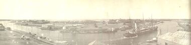
Glenelg Shire Council Cultural Collection
Photograph - Photograph - Portland Harbour, n.d
Black and white photo. View over harbour to Portland, taken from Battery Point.Back: 'Panoramic view of Portland from Battery Point'portland harbour, battery point -
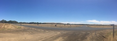 Ballarat Heritage Services
Photograph, Henty, 2015, 22/12/2015
Panoramic view of farmlandy at Henty. -
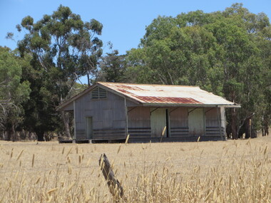 Ballarat Heritage Services
Photograph, Henty Railway Siding, 2015, 22/12/2015
Panoramic view of farmlandy at Henty. -
 Ballarat Heritage Services
Photograph, Henty Fire Brigade, 2015, 22/12/2015
Panoramic view of farmlandy at Henty. -
Port Fairy Historical Society Museum and Archives
Photograph
Men's bathing boxes South Beach with group of men and boysBlack and white panoramic photograph South Beach beach, bathing boxes - men's, diving board, south beach, pea soup -
 Clunes Museum
Photograph, PHOTOGRAPH BY C.J. ROWE
COLOUR PHOTOGRAPH OF A PANORAMIC VIEWlocal history, photography, photograph, panoramic view -
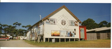 Orbost & District Historical Society
coloured photographs, Hogeman, Trudi, 2000 - 2010
The first two photographs are of the Marlo Picture Theatre which used to be next to the general store.It was a cream coloured timber building with steps leading to a door. There are large poster type paintings on the outside walls. In about 1930, the Ozone Picture Theatre was constructed, serving as a hall and venue for entertainment. In 1925 Walter Rice built a general store in Marlo and in 1930 built the "Ozone Picture Theatre". The third photograph is of the Snowy River Store, a Budget Rite Store. Jack Unmade and his son, Brad ran the store in the 1990s and had a caravan behind the store.This is a pictorial record of a community building no longer standing.Three panoramic format coloured photographs. -
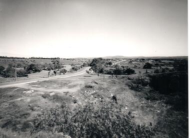 Hume City Civic Collection
Photograph, Early 1970s
A panoramic view of Sunbury looking west.sunbury township, macedon street, george evans collection -
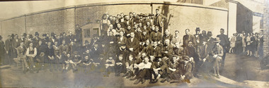
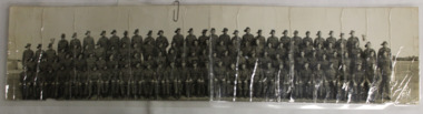 Dandenong/Cranbourne RSL Sub Branch
Photograph, 60th Battallion AIF
Panoramic photograph of the 60th Battallion AIF -
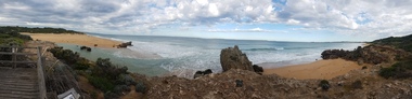
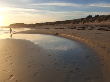 Ballarat Heritage Services
Photograph - Photograph - Colour, Clare Gervasoni, Killarney Beach, Victoria, 26/12/2019
Killarney Beach is located at the end of Mahoney's Road. It is sheltered from wave action by offshore reefs. Panoramic photograph of Killarney Beach, Victoria.killarney beach, coast, beach -
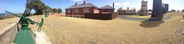
 Ballarat Heritage Services
Photograph - Photograph - Colour, Clare Gervasoni, Fort Queenscliff, 2015, 15/03/2015
Fort Queenscliff was established in 1860 when an open battery was constructed on Shortland's Bluff to defend the Port Phillip Bay entrance. The Fort, which underwent major redevelopment in the late 1870s and 1880s, became the headquarters for an extensive chain of forts around Port Phillip Heads. Its garrison included volunteer artillery, engineers, infantry and naval militia, and it was manned as a coastal defence installation continuously from 1883 to 1946. The other fortifications and armaments around the Heads were completed by 1891, and together made Port Phillip one of the most heavily defended harbours in the British Empire. It is claimed that the first British Empire artillery shots of World War One were fired when a gun at Fort Nepean fired across the bow of the German freighter Pfalz, as she was attempting to escape to sea. The orders to fire came from Fort Queenscliff. It is alleged that the same gun, with a different barrel, also fired the first Australian artillery shot of World War II. By 1946 coastal artillery was outmoded, and the Fort became home of Army's Staff College. After the three Service Staff Colleges were combined in Canberra, it became the base for Army's Soldier Career Management Agency in 2001.Colour panoramic photograph of Fort Queenscliffqueenscliff, fort queenscliff, army, volunteer forces -
 Ballarat Heritage Services
Photograph - Photograph - Colour, Fort Queenscliff, 2015, 15/03/2015
Fort Queenscliff was established in 1860 when an open battery was constructed on Shortland's Bluff to defend the Port Phillip Bay entrance. The Fort, which underwent major redevelopment in the late 1870s and 1880s, became the headquarters for an extensive chain of forts around Port Phillip Heads. Its garrison included volunteer artillery, engineers, infantry and naval militia, and it was manned as a coastal defence installation continuously from 1883 to 1946. The other fortifications and armaments around the Heads were completed by 1891, and together made Port Phillip one of the most heavily defended harbours in the British Empire. It is claimed that the first British Empire artillery shots of World War One were fired when a gun at Fort Nepean fired across the bow of the German freighter Pfalz, as she was attempting to escape to sea. The orders to fire came from Fort Queenscliff. It is alleged that the same gun, with a different barrel, also fired the first Australian artillery shot of World War II. By 1946 coastal artillery was outmoded, and the Fort became home of Army's Staff College. After the three Service Staff Colleges were combined in Canberra, it became the base for Army's Soldier Career Management Agency in 2001.Colour panoramic photograph of Fort Queenscliffqueenscliff, fort queenscliff, army, volunteer forces -
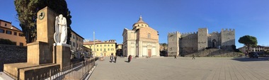 Ballarat Heritage Services
Photograph - Colour, Prato, Italy, 2017, 2017
Monash University has a campus in Prato.Colour panoramic photograph of Prato, Italy. prato, architecture, italy -
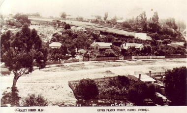 Clunes Museum
Photograph, VALENTINE & SONS PUBLISHING CO.LTD MELBOURN, SYDNEY, BRISBANE
PANORAMIC VIEW OF UPPER FRASER STREET, CLUNESMERRY CHRISTMAS TO ALL FROM CARIN CLUNES.YAlocal history, photography, photographs, clunes township, upper fraser street. -
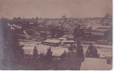
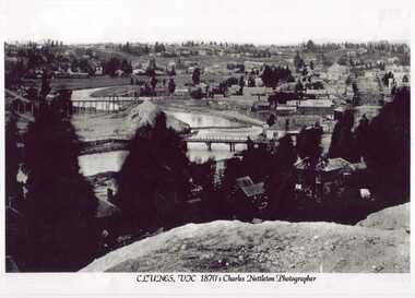 Clunes Museum
Photograph - PHOTOGRAPH CLUNES 1870, PHOTOGRAPHER - CHARLES NETTLETON
BLACK AND WHITE PANORAMIC VIEW OF CLUNES 1870local history, clunes landscape, township, photograph clunes -
 Ballarat Heritage Services
Digital photographs, L.J. Gervasoni, Hopkins River Mouth - panorama, c2010 - 2017
Panoramic photograph of the mouth of the Hopkin's River at Warrnambool.hopkins river, mouth, point ritchie, bluehole, warrnambool, coast, coastal, beach, seascape, coastal geomorphology, pano -
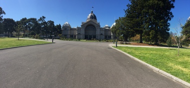 Ballarat Heritage Services
Photograph - Photograph - Colour, Clare Gervasoni, Royal Exhibition Building Melbourne, 2018, 10/2018
Panoramic photograph of the Royal Exhibition Building in Melbourne. royal exhibition building, architecture, carlton gardens -
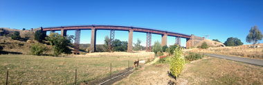 Ballarat Heritage Services
Photograph - Photograph - Colour, Clare Gervasoni, Taradale Viaduct, 2015, 29/03/2015
The contractors for the Melboirne to Sandhurst railway line were Conish and Bruce. The five bluestone columns stand up to 36.6 metres above Back Creek. In 1933-1934, after heavier steam trains with longer loads commenced usng the bridge pre fabricated steel columns were placed under the bridge.Panoramic photographs of the bluestone viaduct at Taradale, Victoriataradale viaduct, taradale, bluestone, bridge, cornish & cruce, railway -
 Port Fairy Historical Society Museum and Archives
Photograph
Black and white panoramic photograph of the Moyne rivership, boat, sea, river, ss casino -
 Clunes Museum
Photograph, HORNBY STUDIOS - CLUNES, PORT PHILLIP MINE
.1 BLACK AND WHITE PHOTOGRAPH PANORAMIC VIEW PORT PHILLIP MINE 1870. .2 MOUNTED SEPIA PHOTOGRAPH PANORAMIC VIEW OF PORT PHILLIP MINEPORT PHILLIP 1870photographs, port phillip mine, mine 1870 -
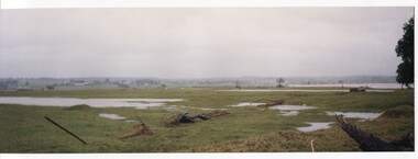 Orbost & District Historical Society
coloured photographs, Hogeman, Trudi, 2000 - 2010
These photographs are of floodwaters on the river flats of Orbost, near Gilberts Gulch on the Marlo Road showing large lumps of wood in the middle of the road and a red vehicle in the background. 3090.4 has been taken looking down onto theSnowy Rive from near Mitchells / Griebenows Road Newmerella.This is a pictorial record of a significant flood event in Orbost.Four panoramic colour photographs showing the aftermath of a flood. flood-orbost-2000s -
4th/19th Prince of Wales's Light Horse Regiment Unit History Room
Panoramic Post Card, Early 1900's
A four part panoramic post card photograph of AleppoPlatin Crayon O.I.M 677:06 Carte Postalepost card, aleppo -
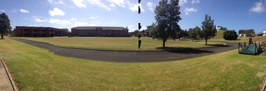
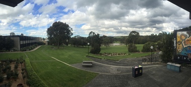 Federation University Historical Collection
Photograph, Clare Gervasoni, Federation University Gippsland Campus, 2017, 03/10/2017
Federation University Australia was established on 1 January 2014. Formerly known as the University of Ballarat, its enabling legislation was the University of Ballarat Amendment (Federation University Australia) Act 2013. On 1 January 2014, the University of Ballarat amalgamated with the Monash University Gippsland Campus to form Federation University Australia. The Gippsland Campus also had a long lineage dating back to 1928 with the establishment of the Yallourn Technical School which became a predecessor institution to the Gippsland College of Advanced Education formed in 1968. In 1990, it was renamed the Monash University College and in 1993 became the Gippsland Campus of Monash University. In 2016, Federation University Australia announced plans to take possession, over a two-year period, of Monash’s Berwick Campus in the south-east corridor of Melbourne. Federation University Australia, or FedUni, is headquartered in Ballarat and offers programs in Higher Education and Vocational Education and Training to regional Victoria and beyond. The University’s commitment to educational and social equity, teaching excellence, research distinction, environmental sustainability and regional capacity building has enabled it to develop in a way that draws on its proud heritage to inform its future. Its regional character sets a framework for the University’s priorities but does not constrain it from serving wider community interests, nationally and internationally. The name Federation University Australia was chosen to convey the scope and capacity of an expanded regional university with a federated network of campuses. Colour panoramic photorgraph of the Federation University Gippsland Campus.federation university, gippsland campus, churchill campus -
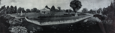 Federation University Historical Collection
Photograph - Black and White, Ballarat Botanic Gardens, c.1880, c 1880
Panoramic, black and white photograph of Ballarat Botanic Gardensballarat, photograph, black and white, botanic gardens, ballarat botanic gardens, ballarat botanical gardens, statue pavillion