Showing 171 items matching "phillip island map"
-
 Phillip Island and District Historical Society Inc.
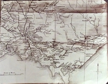
Photograph, Rail Lines of Victoria, Early to mid 20th century
Map showing extensive railway network in Victoria in early C20th.Sepia photo of map of Victoria showing rivers and railway lines and stations.Names of towns, rivers, bays etcsepia photograph, rail transport, victoria, map -
 Phillip Island and District Historical Society Inc.
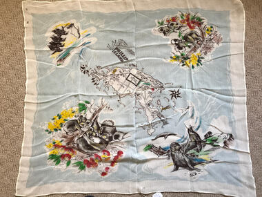
Scarf, Scarf with Map, flowers and animals of Phillip Island, c 1950's
... , flowers and animals of Phillip Island. Scarf with Map, flowers ...Scarf possibly owned by Alice Robinson (nee Clark)Nylon scarf with map, flowers and animals of Phillip Island.Phillip Island and names of towns and places of interest.souvenir scarf, alice robinson -
 Phillip Island and District Historical Society Inc.
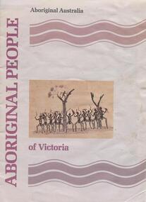
book, Aboriginal people of Victoria, 1990
15 p. : ill. (some col.), map, ports. ; 30 cm. Cover title. Cat. no. 8907893. Bibliography: p. 15. ISBN 0644101547Stamped: Phillip Island & District Historical Societyrichard broome, aboriginal people of victoria, aboriginal australia. culture and society, aboriginal australians -- australia -- victoria., aboriginal and torres strait islander commission -
 Phillip Island and District Historical Society Inc.
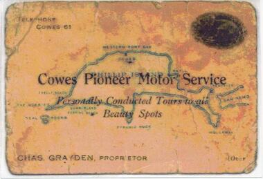
Photograph, 1925 - 1936
... Business Card. Map of Phillip Island in the background. 2. Colour... of Charles Grayden's Business Card. Map of Phillip Island ...Two of a collection of 6 photographs donated by Anne Grayden. First photograph "Registration" No. 199-05 Second Photograph "Registration" No. 199-061. Colour photograph of front of Charles Grayden's Business Card. Map of Phillip Island in the background. 2. Colour photograph of back of Charles Grayden's Business Card.1. On Front: Telephone Cowes 61 - Cowes Pioneer Motor Service - Personally Conducted Tours to all Beauty Spots - Chas. Grayden, Proprietor - [over On Back: Business Card of Charles Grayden 1925 - 1936. 2. On Front: Personally Conducted Tours to all Beauty Spots including Nobbies & Summerland Surfing Beach, Newhaven, Forrest's Caves & Rhyll. Evening Trips to Mutton Bird & Penguin Rookeries. Agents for Ideal Summerland. Booking Office, opposite Pier, near Koala Cafe.charles grayden, cowes pioneer motor service, anne grayden, tourism phillip island -
 Phillip Island and District Historical Society Inc.
Book, Aboriginal string bags : nets and cordage, 1999
xv, 157 p. : ill., maps ; 24 cm. Occasional papers, Anthropology and History ; To The Phillip Island and District Historical Society, With best wishes, Alan West, July 2001fibers, string craft, australia, rope, aboriginal australians, industries -
Phillip Island and District Historical Society Inc.
Book, Aboriginal string bags : nets and cordage, 1999
xv, 157 p. : ill., maps ; 24 cm. Occasional papers, Anthropology and History ; Inscribed 'To Phillip Island & District Historical Society with best wishes from Alan West, January 2000'.fibers, string craft, australia, rope, aboriginal australians, industries -
Phillip Island and District Historical Society Inc.
Book, Broadbent's Official Road Guides Company, Broadbent's official guide : Gippsland and south-east corner of N.S.W. incorporating large scale maps, 1950
J.P. Anderson, 97 Salmon St., Hastings'victoria, guidebooks -
Phillip Island and District Historical Society Inc.
Book, Chambers, Chambers's encyclopaedia : a dictionary of universal knowledge for the people, illustrated with maps and numerous wood engravings, 1862
Museum holds v.4. Elephant to Gongora. Stamped 'Phillip Island & District Historical Society'. -
Phillip Island and District Historical Society Inc.
Book, WELLS, John, Colourful tales of old Gippsland, 1990
Maps on endpapers. First published Rigby, 1977. Includes bibliographical references.gippsland, history -
Phillip Island and District Historical Society Inc.
Book, William Collins, library atlas : consisting of one hundred and ten maps of modern, historical, and classical geography, &c., with descriptive letterpress of Modern geography by James Bryce, Historical geography by William F. Collier, Classical geography by Leonard Schmitz; with copious indices, 1876?
Inscribed: Hazel Fair, 37 Laura St., E. Bruns. N. 10. Stamped: J.R. Mann, Bookseller, Victoria Market ; Phillip Island & District Historical Society -
Phillip Island and District Historical Society Inc.
Book, LOVE, Don, Shipwrecks on the South Gippsland Coast, 2005
Maps on endpapers. Includes bibliographical references and indexes.shipwrecks, victoria, south gippsland, history -
Phillip Island and District Historical Society Inc.
Book, F.E. Hiscocks &? Co, F.E. Hiscocks &? Co.'s new Victorian counties atlas, 1874 [cartographic material] : together with map of Victoria, indicating roads, distances, relative position of counties, &?c, 1874
Labelled 'Cowes Free Public Library', 'Phillip Island Historical Society, Cleeland Bequest'.victoria, maps -
Phillip Island and District Historical Society Inc.
Book, Whitehead, Whitehead's new map of Victoria with alphabetical key 1867-8, 1868
-
 Phillip Island and District Historical Society Inc.
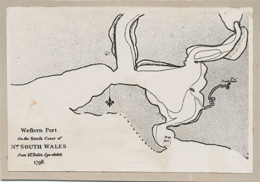
Photograph, Bryant West, 1798
... Photograph of the First Map of Phillip Island ever drawn... documents maps george bass phillip island bryant west john jenner ...One of a collection of over 400 photographs in an album commenced in 1960 and presented to the Phillip Island & Westernport Historical Society by the Shire of Phillip IslandPhotograph of the First Map of Phillip Island ever drawn. An eye sketch by Bass.As written on front of map - "Western Port on the South Coast of Nw. South Wales from GE Bass's Eye-sketch 1798"local history, photography, photographs, exploration, maritime, documents, maps, george bass, phillip island, bryant west, john jenner -
 Phillip Island and District Historical Society Inc.
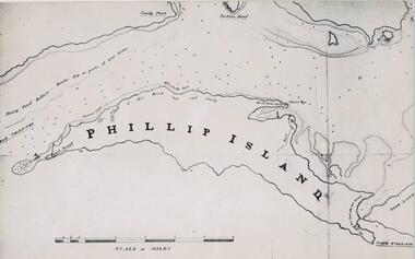
Photograph, Bryant West
... Photograph of a Map of Phillip Island. The first to show... documents maps phillip island john jenner bryant west Photograph ...One of a collection of over 400 photographs in an album commenced in 1960 and presented to the Phillip Island & Westernport Historical Society by the Shire of Phillip IslandPhotograph of a Map of Phillip Island. The first to show Fort Dumaresq, track to beach and beginning of road to South coast. local history, photography, photographs, exploration, maritime, documents, maps, phillip island, john jenner, bryant west -
 Phillip Island and District Historical Society Inc.
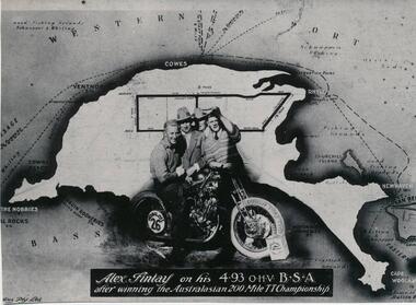
Photograph
... on a map of Phillip Island... motor cycle superimposed on a map of Phillip Island Photograph ...One of a collection of over 400 photographs in an album commenced in 1960 and presented to the Phillip Island & Westernport Historical Society by the Shire of Phillip IslandPhotograph of Alex Findlay on his motor cycle superimposed on a map of Phillip IslandAlex Findlay on his 4.93 OHV B.S.A. after winning the Australasian 200 mile TT Championshiplocal history, photography, souvenir, phillip island's first motor cycle race, black & white photograph, phillip island race track, motor cycle racing, alex findlay, john jenner, bryant west -
 Phillip Island and District Historical Society Inc.
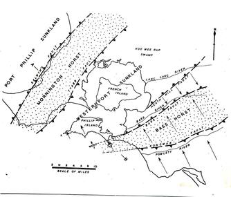
Sketch
One of a collection of over 400 sketches & photographs in an album commenced in 1960 and presented to the Phillip Island & Westernport Historical Society by the Shire of Phillip IslandSketch Map of Westernport region and environs showing physiographical faults and warps. Drawn by Dr G Bakerlocal history, illustrations, pen & ink, westernport region, black & white sketch, physiography, dr g baker, e s hill d.sc, john jenner, bryant west -
 Phillip Island and District Historical Society Inc.
Sketch
One of a collection of over 400 sketches & photographs in an album commenced in 1960 and presented to the Phillip Island & Westernport Historical Society by the Shire of Phillip IslandSketch map of Westernport Bay region showing probable drainage directions of the ancient river system. Drawn by Dr G Baker from original maps by E S Hills D.Sc.local history, illustrations, pen & ink, westernport bay region, black & white sketch, physiography, dr g baker, e s hill d.sc, john jenner, bryant west -
 Phillip Island and District Historical Society Inc.
Photograph
... map of phillip island... Island local history photography map of phillip island black ...One of a collection of over 400 photographs in an album commenced in 1960 and presented to the Phillip Island & Westernport Historical Society by the Shire of Phillip IslandPhotograph of the original draft of the map making of the end papers for the book "Phillip Island in Picture & Story"local history, photography, map of phillip island, black & white photograph, maps & mapping, phillip island in picture & story, john jenner, bryant west -
 Eltham District Historical Society Inc
Book, Melway Great Melbourne street directory including Geelong, Phillip Island Healesville, Bellarine & Mornington Peninsulas, 1998
25th edition. Coloured detailed maps accessed by a street or location index. Cover: (Includes) New Southbank map including Crown Complex, enlargements of Footscray and Kensington, bike paths, walking tracks & horse trails, latest public transport information, South east Australia tours maps, Vic Roads new route numbers, map of Australia1 atlas (22, 772 p.) : col. maps ; ISSN 03113957streets, maps, roads, melbourne -
 Eltham District Historical Society Inc
Book, Melway Publishing, Melway Greater Melbourne street directory : including Geelong, Phillip Island, Healesville, Bellarine & Mornington Peninsulas, 2002
Edition 29. Coloured detailed maps accessed by a street or location index. Cover: 20 additional pages of new maps, extended coverage of Bellarine Peninsula, further coverage of Werribee South, Public Transport Information, latest official suburb boundaries, CBD "hook turn" intersections map, over 1200 new streets, 1 atlas (24, 886 p.) : col. maps ; ISSN 03113957streets, roads, melbourne, maps, melway -
 Federation University Historical Collection
Map, Portarlington, 1929, 09/1929
Printed colour mapport arlington, corio bay, port phillip bay, clifton springs, swan bay, swan island, duck island, point wilson -
 Flagstaff Hill Maritime Museum and Village
Book, The Logbooks of The Lady Nelson, 1915
This hardcover book, The logbooks of the 'Lady Nelson' : with the journal of her first commander, Lieutenant James Grant, R.N., by Ida Lee (Mrs Charles Bruce Marriott) was published over 100 years after the Lady Nelson arrived in Australia to navigate and survey this ‘new colony’. Included in the book are sixteen charts and illustrations from the originals in the Admiralty Library, showing the surveyed land and water. The transcribed Contents, below, summarise the trips of the Lady Nelson during this time. Book’s Content PLUS text of the Chart of ‘Part of Bass Strait’ - Chapter 1: The Lady Nelson built with centreboards. Her voyage to Sydney under James Grant. The first ship to pass through Bass Strait. - Chapter 2: Returns to explore the Strait. Her visits to Jervis Bay and to Western Port in 1801 - Chapter 3: Colonel Paterson and Lieutenant Grant survey Hunter River - Chapter 4: Murray appointed commander of the Lady Nelson. His voyage to Norfolk Island. - Chapter 5: Murray’s exploration of Bass Strait. - Chapter 6: Discovery of Port Phillip. - Chapter 7: The Lady Nelson in company with HMS Investigator examines the North-Eastern shores of Australia. - Chapter 8: The French ships in Bass Strait. The founding of Hobart. - Chapter 9: Symons succeeds Curtoys as commander of the Lady Nelson. His voyages to Tasmania, Port Phillip and New Zealand. - Chapter 10: The Lady Nelson in Tasmania. The founding of Port Dalrymple. - Chapter 11: The Estramina is brought to Sydney. The Lady Nelson visits Norfolk Island and Port Dalrymple. - Chapter 12: Tippahee and his four sons are conveyed to New Zealand in the Lady Nelson. - Chapter 13: The Lady Nelson accompanies HMS Tamar to Melville Island. - Chapter 14: The loss of the Lady Nelson Text included with the ‘Chart of Bass Strait’ … “Part of Bass Strait, including the discoveries made by Acting Lieut. J. Murray, commander of His Majesty’s armed surveying vessel Lady Nelson, between November 1801 and March 1802. By command of His Excellency Governor King.” “This chart, which bears Murray’s autograph, shows his explorations of Western Port, Port Phillip and King Island. It should be noted that Flinders Island is named Grand Capuchin. This is one of the charts referred to as "unfortunately missing” in the Historical Records of N.S. Wales, vol. iv. P. 764” The story of the Lady Nelson In 1798 the British Admiralty ordered a cutter of 60 tons to be built along the design of the armed cutter Trial that was developed by Captain John Schanck, with three sliding keels or centreboards that could be individually raised and lowered, for use on the River Thames. The new cutter was to be named Lady Nelson. Philip Gidley King, prior to taking up his appointment as third Governor of the colony of New South Wales, was in England at the time of the Lady Nelson’s fit-out and was aware of the need for such a ship for survey work in the colony in New South Wales. He convinced Captain Schanck, the Commissioner of Transport in England, to construct and rig the Lady Nelson as a brig rather than a cutter, keeping the feature of the three sliding keels, which would be very useful for mapping in shallow waters. The new Lady Nelson was launched at Deptford, England on the River Thames in November 1798, with the official commission to discover and survey the unknown parts of the coast of New Holland (Australia) and establish British sovereignty over the continent. The Lady Nelson sailed from Portsmouth, England on March 1800 under the command of Lieutenant James Grant. She carried an armament of two original and four extra brass carronade carriage guns and set sail as part of a convoy heading to Port Jackson, in New South Wales, New Holland. After a while she continued to sail on her own. Her journey was troubled with problems at times; damaged and broken keels, troublesome crew and leaking topsides between the waterline and the deck due to poor seals. She arrived at the Cape of Good Hope in July and waited for the winter to pass to avoid the strong winds of the ‘Roaring Forties’. While at the Cape, Grant received a despatch to travel to Port Jackson via the newly discovered Bass Strait, rather than the usual route via the tip of Van Diemen’s Land (Tasmania). This also gave him the opportunity to survey the strait on the way. He departed the Cape in October and in December he made his first sighting of New Holland near Mount Gambier in what is now South Australia. A report by Ecclestone in 2012, ‘The Early Charting of Victoria’s Coastline’, mentions that Grant charted and named Capes Banks and Northumberland, and sighted inland hills that he named Mt Gambier and Mt Schanck, the latter after the designer of his ship. Grant then reached the south-western shores of what is now Victoria on 3-4 December 1800, and from Cape Bridgewater he examined the coast eastward to Cape Patton. Although he had not continuously sighted the coast in the vicinity of Port Fairy and Warrnambool, the western part of Victoria became known as Grant’s Land. The Lady Nelson continued eastward and passed through Bass Strait, becoming the first vessel to reach the east coast of New Holland from the west, and arrived at her destination of Port Jackson later in December 1800. Grant, in the Lady Nelson, then left Port Jackson and began survey work. He discovered Port Phillip on Victoria’s coast and explored King Island, he helped establish the first European settlement in Tasmania on the Derwent River, and Port Dalrymple, Newcastle and Port Macquarie. He made several trips from Norfolk Island to Hobart Town. Governor Macquarie sailed on with him to Van Diemen’s Land for a tour of inspection in 1811. Grant helped establish the first settlement on Melville Island in Northern Australia. The Lady Nelson was used to transport cargo, civilians and convicts and to source pigs from Timor. In February 1825 the Lady Nelson sailed again for Timor and never returned. One report said that “Every soul on board, we regret to state, was cruelly massacred, and the hull of the vessel was seen some time after with the name painted on her stern.” The hull was sighted on the island of Babar, which is almost 200 kilometres east of Timor. This particular copy of the book ... This item is from the ‘Pattison Collection’, a collection of books and records that was originally owned by the Warrnambool Mechanics’ Institute, which was founded in Warrnambool in 1853. By 1886 the Warrnambool Mechanics’ Institute (WMI) had grown to have a Library, Museum and Fine Arts Gallery, with a collection of “… choice productions of art, and valuable specimens in almost every branch and many wonderful national curiosities are now to be seen there, including historic relics of the town and district.” It later included a School of Design. Although it was very well patronised, the lack of financial support led the WMI in 1911 to ask the City Council to take it over. In 1935 Ralph Pattison was appointed as City Librarian to establish and organise the Warrnambool Library as it was then called. When the WMI building was pulled down in 1963 a new civic building was erected on the site and the new Warrnambool Library, on behalf of the City Council, took over all the holdings of the WMI. At this time some of the items were separated and identified as the ‘Pattison Collection’, named after Ralph Pattison. Eventually the components of the WMI were distributed from the Warrnambool Library to various places, including the Art Gallery, Historical Society and Flagstaff Hill. Later some were even distributed to other regional branches of Corangamite Regional Library and passed to and fro. It is difficult now to trace just where all of the items have ended up. The books at Flagstaff Hill Maritime Village generally display stamps and markings from Pattison as well as a variety of other institutions including the Mechanics’ Institute itself. RALPH ERIC PATTISON Ralph Eric Pattison was born in Rockhampton, Queensland, in 1891. He married Maude Swan from Warrnambool in 1920 and they set up home in Warrnambool. In 1935 Pattison accepted a position as City Librarian for the Warrnambool City Council. His huge challenge was to make a functional library within two rooms of the Mechanics’ Institute. He tirelessly cleaned, cleared and sorted a disarrayed collection of old books, jars of preserved specimens and other items reserved for exhibition in the city’s museum. He developed and updated the library with a wide variety of books for all tastes, including reference books for students; a difficult task to fulfil during the years following the Depression. He converted all of the lower area of the building into a library, reference room and reading room for members and the public. The books were sorted and stored using a cataloguing and card index system that he had developed himself. He also prepared the upper floor of the building and established the Art Gallery and later the Museum, a place to exhibit the many old relics that had been stored for years for this purpose. One of the treasures he found was a beautiful ancient clock, which he repaired, restored and enjoyed using in his office during the years of his service there. Ralph Pattison was described as “a meticulous gentleman whose punctuality, floorless courtesy and distinctive neat dress were hallmarks of his character, and ‘his’ clock controlled his daily routine, and his opening and closing of the library’s large heavy doors to the minute.” Pattison took leave during 1942 to 1945 to serve in the Royal Australian Navy, Volunteer Reserve as Lieutenant. A few years later he converted one of the Museum’s rooms into a Children’s Library, stocking it with suitable books for the younger generation. This was an instant success. In the 1950’s he had the honour of being appointed to the Victorian Library Board and received more inspiration from the monthly conferences in Melbourne. He was sadly retired in 1959 after over 23 years of service, due to the fact that he had gone over the working age of council officers. However he continued to take a very keen interest in the continual development of the Library until his death in 1969 This book about the logbooks of the Lady Nelson is locally significant for its association with the brig Lady Nelson, in which Lt. James Grant made the first documented European discovery of the area later known as Warrnambool in December 1800. This book is also nationally significant for its association with Grant in the Lady Nelson being the first to sail from west to east through Bass Strait, opening up a shorter, faster route to the colony of Port Jackson rather than going all the way south around Van Diemen’s Land. The book is nationally significant for its contents of the logbooks of the journeys of the Lady Nelson under various commanders and the copies of the charts created from the surveyed information and the new land of Australia was discovered. This book is also significant for its association with the full-size non-sailing replica of the Lady Nelson from Mount Gambier’s visitor centre, which was restored by Flagstaff Hill’s Master Boat Builder in Warrnambool in 2012, and with a ship mode of the Lady Nelson in our Collection The Pattison Collection, along with other items at Flagstaff Hill Maritime Village, was originally part of the Warrnambool Mechanics' Institute’s collection. The Warrnambool Mechanics’ Institute Collection is primarily significant in its totality, rather than for the individual objects it contains. Its contents are highly representative of the development of Mechanics' Institute libraries across Australia, particularly Victoria. A diversity of publications and themes has been amassed, and these provide clues to our understanding of the nature of and changes in the reading habits of Victorians from the 1850s to the middle of the 20th century. The collection also highlights the Warrnambool community’s commitment to the Mechanics’ Institute, reading, literacy and learning in the regions, and proves that access to knowledge was not impeded by distance. These items help to provide a more complete picture of our community’s ideals and aspirations. The Warrnambool Mechanics Institute book collection has historical and social significance for its strong association with the Mechanics Institute movement and the important role it played in the intellectual, cultural and social development of people throughout the latter part of the nineteenth century and the early twentieth century. The collection of books is a rare example of an early lending library and its significance is enhanced by the survival of an original collection of many volumes. The Warrnambool Mechanics' Institute’s publication collection is of both local and state significance. The Logbooks of The Lady Nelson Author: Ida Lee ( Mrs Charles Bruce Marriott) Publisher: Grafton & Co Date: 1915Label on spine with typed text RA 910.994 LEE Inside front cover has a sticker that reads Warrnambool Mechanics Institute and Free Library shipwrecked-coast, flagstaff-hill, warrnambool, flagstaff-hill-maritime-museum, maritime-museum, shipwreck-coast, flagstaff-hill-maritime-village, shipwrecked-artefact, book, warrnambool library, warrnambool mechanics’ institute, warrnambool city librarian, mechanics’ institute library, victorian library board, warrnambool books and records, warrnambool children’s library, great ocean road, the logbooks of the lady nelson, ida lee, mrs charles bruce marriott, captain john schanck, sliding keels or centreboards, lady nelson, british brig hms lady nelson, lieutennant james grant, bass strait discovery, surveying king island and port phillip bay, philip gidley king, survey map -
 Ringwood and District Historical Society
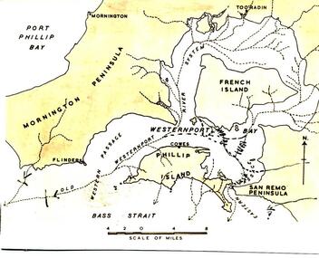
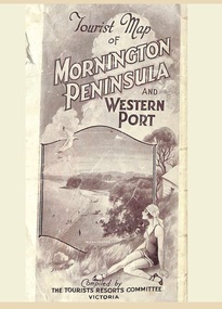
Memorabilia, Tourist Map of Mornington Peninsula and Western Port - 1929
Multi-fold pictorial map of towns, railways and main roads east of Port Phillip Bay from Melbourne to Yarra Junction and south to Phillip Island and Wonthaggi, backed by details of main features and points of interest.Photo-Lithographed by Department of Lands and Survey, Melbourne, 2.8.1929. -
 National Vietnam Veterans Museum (NVVM)
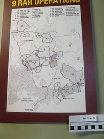
Poster - Poster, Information Board, 9 RAR Operations
Map of 9 RAR operations with a burgundy background. there is a list of operations and dates on the board9 rar, map of operations, poster, information board -
 National Vietnam Veterans Museum (NVVM)
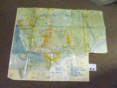
Map, C. 1969 - 70
Colour map of Vietnam with military locations shown.map, vietnam -
 National Vietnam Veterans Museum (NVVM)
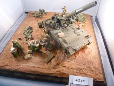
Model - Diorama, M-107 Self propelled artillery
Self propelled gun with blade to dig its own bund. Crew of seven. At rest, one soldier is with a map, one soldier is looking at a magazine, while another soldier is unpacking ammunition.Word PACHELBEL? appears on the gun barrelpachelbel, m-107, self propelled artillery, diorama -
National Vietnam Veterans Museum (NVVM)
Audio - Audio, CD, Coral/Balmoral Map for NVVM
Package contains 1 Audio, CD of the map; paperwork pertaining to the battlevietnam war, 1961-1975 - battlefields - balmoral, vietnam war, 1961-1975 - battlefields - coral -
 National Vietnam Veterans Museum (NVVM)
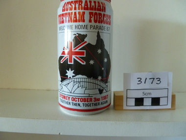
Memorabilia, Beer Can
Commemoration Australian Vietnam Forces Welcome Home Parade '87. Map of Australia with flag superimposed and picture of the Sydney Harbour Bridge and the OperaHhouse.Australian Vietnam Forces Welcome Home Parade '87, Sydney October 3rd 1987, together then, together againbeer can, welcome home parade -
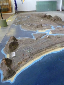 National Vietnam Veterans Museum (NVVM)
Map - Map, Relief, PHU
Raised relief map of Phuoc Tuy province. Six pieces showing land features from Long Hai hills to coast at Vung Tau baserelief map, phuoc tuy