Showing 77 items
matching pioneer reserve
-
 Eltham District Historical Society Inc
Photograph, Tom Prior, Group of scenes from the Eltham District, c.1905
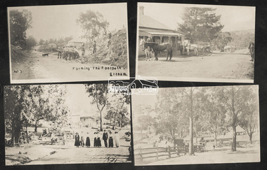
Photo shows four images from the Shire of Eltham Pioneers Photograph Collection: SEPP_0501: West's Research Hotel, Main Road, Research, c.1907 SEPP_0612: Eltham, Main Road. Looking north from corner of Dudley Street, c.1904 SEPP_0616: Forming the footpath, Eltham, c.1906 SEPP_1000: Main Road, Hurstbridge, c.1905 Black and white/sepia photograph of four individual photographsbakery, eltham, eltham village reserve, footpath, gahan house, general store, haley's paddock, hurstbridge, luther haley, luther haley general store, main road, old mac (horse), picnic, pioneers and painters, punch (horse), railway store, research (vic.), research hotel, reynolds prior collection, richard reynolds, road construction, sepp, shire of eltham pioneers photograph collection, summer drinks, tilley lamp, york street -
 Eltham District Historical Society Inc
Negative - Photograph, The Bridge, Hurstbridge, Vic, c.1925
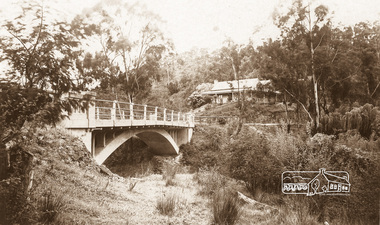
Copied from brochure "Wattle Valley Estate" 7 minutes from the bridge. The new bridge designed by Sir John Monash over the Diamond Creek near Hurst's home of 'Mia Mia' at Hurstbridge. The Wattle Valley Estate was first advertised in August 1925 as weekend building allotments by the Greater Melbourne Land and Development Company. Advertised from £28.10.0 or £60 per block. In August 1926, 30 picked allotments of 60x150 feet were put up for auction Saturday August 14, 1926 with frontages to Valley View Road and Fawkner Crescent advertised in the “Heart of the Glorious Wattle Country” and “Within 15 Minutes of the Newly Electrified Railway Station”. The Advertiser on August 13, 1926 in an article promoting the auction stated “the estate is regarded as one of the best in the district, and will be sold practically without reserve.” It is noted that an advertisement running in The Argus February 22, 1951 offered the remaining 16 blocks for sale at £12.10.0 or £200 the lot. By March 7, the remaining blocks were advertised at £17.10.0 The Wattle Valley Estate took over 20 years to sell and then people could not build on them This image was also used in a brochure advertising the "Wattle Valley Estate", which forms part of the Shire of Eltham Pioneers Photograph Collection (Cross Reference Photo No.(s): 1056, 1057)This photo forms part of a collection of photographs gathered by the Shire of Eltham for their centenary project book,"Pioneers and Painters: 100 years of the Shire of Eltham" by Alan Marshall (1971). The collection of over 500 images is held in partnership between Eltham District Historical Society and Yarra Plenty Regional Library (Eltham Library) and is now formally known as the 'The Shire of Eltham Pioneers Photograph Collection.' It is significant in being the first community sourced collection representing the places and people of the Shire's first one hundred years.Digital image 4 x 5 inch B&W Negshire of eltham pioneers photograph collection, hurstbridge, bridge, diamond creek (creek), monash bridge, wattle valley estate -
 Eltham District Historical Society Inc
Negative - Photograph, Rose Stereograph Company, The Bridge, Hurstbridge, Vic, c.1925
Copied from brochure "Wattle Valley Estate". The new bridge designed by Sir John Monash over the Diamond Creek near Hurst's original home "Mia Mia" seen in the distance. Reprinted from brochure advertising "Wattle Valley Estate" 7 minutes from bridge. The Wattle Valley Estate was first advertised in August 1925 as weekend building allotments by the Greater Melbourne Land and Development Company. Advertised from £28.10.0 or £60 per block. In August 1926, 30 picked allotments of 60x150 feet were put up for auction Saturday August 14, 1926 with frontages to Valley View Road and Fawkner Crescent advertised in the “Heart of the Glorious Wattle Country” and “Within 15 Minutes of the Newly Electrified Railway Station”. The Advertiser on August 13, 1926 in an article promoting the auction stated “the estate is regarded as one of the best in the district, and will be sold practically without reserve.” It is noted that an advertisement running in The Argus February 22, 1951 offered the remaining 16 blocks for sale at £12.10.0 or £200 the lot. By March 7, the remaining blocks were advertised at £17.10.0 The Wattle Valley Estate took over 20 years to sell and then people could not build on them This image was also used in a brochure advertising the "Wattle Valley Estate", which forms part of the Shire of Eltham Pioneers Photograph Collection (Cross Reference Photo No.(s): 1056, 1057). Also cross reference SEPP_1028 / 29 for other views of Mia Mia. Part of a slide show presentation "Bridges & Waterways of the Shire" by Russell Yeoman to the 13 September 1989 Society meeting. The presentation included slides of historic photos from the Shire of Eltham Pioneers collections as well as several recent views. This photo forms part of a collection of photographs gathered by the Shire of Eltham for their centenary project book,"Pioneers and Painters: 100 years of the Shire of Eltham" by Alan Marshall (1971). The collection of over 500 images is held in partnership between Eltham District Historical Society and Yarra Plenty Regional Library (Eltham Library) and is now formally known as the 'The Shire of Eltham Pioneers Photograph Collection.' It is significant in being the first community sourced collection representing the places and people of the Shire's first one hundred years.Digital image 4 x 5 inch B&W Negshire of eltham pioneers photograph collection, hurstbridge, mia mia, bridge, diamond creek (creek), monash bridge, wattle valley estate -
 Eltham District Historical Society Inc
Negative - Photograph, Popular Picnicing at Hurstbridge, c.1925
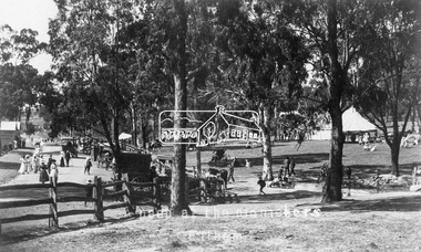
Picnickers enjoying a Sunday outing near the Wattle Valley Estate at Hurstbridge. Copied from brochure "Wattle Valley Estate". It is believed the picture is taken at the northwest corner of the intersection of Wattletree Road and Hurstbridge-Arthurs Creek Road looking southeast towards the township (most likely where the house is located on the property of what is today No. 2 Wattletree Road)- https://goo.gl/maps/VDorwCe1rJJUapjE6 According to a comment by Jean Verso (via @nillumbikcouncil FB page 3 Jan 2020) - "This view is from Wattle Tree Road with Haleys Gully Road to the right and across the creek to William Gray's nursery at Allwood. The building to the far left looks like Dorset House. The building on the left in the middle distance is still there today and has been used for storage and as a stable/tack room for a number of years." The Wattle Valley Estate was first advertised in August 1925 as weekend building allotments by the Greater Melbourne Land and Development Company. Advertised from £28.10.0 or £60 per block. In August 1926, 30 picked allotments of 60x150 feet were put up for auction Saturday August 14, 1926 with frontages to Valley View Road and Fawkner Crescent advertised in the “Heart of the Glorious Wattle Country” and “Within 15 Minutes of the Newly Electrified Railway Station”. The Advertiser on August 13, 1926 in an article promoting the auction stated “the estate is regarded as one of the best in the district, and will be sold practically without reserve.” It is noted that an advertisement running in The Argus February 22, 1951 offered the remaining 16 blocks for sale at £12.10.0 or £200 the lot. By March 7, the remaining blocks were advertised at £17.10.0 The Wattle Valley Estate took over 20 years to sell and then people could not build on them Cross Ref EDHS_02665 Rose Series Postcard P. 4341, "View at Hurstbridge, Vic." Also, other images from sales brochure SEPP_1055 / 1056This photo forms part of a collection of photographs gathered by the Shire of Eltham for their centenary project book,"Pioneers and Painters: 100 years of the Shire of Eltham" by Alan Marshall (1971). The collection of over 500 images is held in partnership between Eltham District Historical Society and Yarra Plenty Regional Library (Eltham Library) and is now formally known as the 'The Shire of Eltham Pioneers Photograph Collection.' It is significant in being the first community sourced collection representing the places and people of the Shire's first one hundred years.Digital image 4 x 5 inch B&W Neg1925, dorset house, fawkner crescent, haleys gully road, hurstbridge, hurstbridge-arthurs creek road, picnic, postcards, shire of eltham pioneers photograph collection, valley view road, wattle valley estate, wattletree road, exhibition yprl 2019-12 -
 Eltham District Historical Society Inc
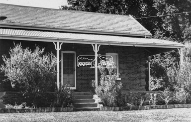
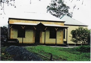
Negative - Photograph, Leader Publishing Co, Wingrove Cottage, c.1970
Wingrove Cottage is historically significant for its long association with Charles Wingrove, a prominent figure in Victorian local government, as secretary to the Eltham District Road Board and Shire Council from 1858 to 1904, and Shire Engineer and Secretary to the Heidelberg Road Board. The cottage was also used as the office of the Eltham District Road Board and Council for many years . One of the Shire's oldest dwellings, and one of the few surviving 19th century buildings associated with early Eltham and located in the original Eltham Village Reserve. Wingrove Cottage is considered historically significant to the Shire of Nillumbik and is registered on the Victorian Heritage Database. This photo forms part of a collection of photographs gathered by the Shire of Eltham for their centenary project book,"Pioneers and Painters: 100 years of the Shire of Eltham" by Alan Marshall (1971). The collection of over 500 images is held in partnership between Eltham District Historical Society and Yarra Plenty Regional Library (Eltham Library) and is now formally known as the 'The Shire of Eltham Pioneers Photograph Collection.' It is significant in being the first community sourced collection representing the places and people of the Shire's first one hundred years.Digital image 4 x 5 inch B&W Neg Print 20 x 25 cmsepp, shire of eltham pioneers photograph collection, eltham, wingrove cottage, charles wingrove, houses -
 Eltham District Historical Society Inc
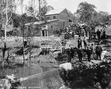
Negative - Photograph, Opening of St. Andrews Battery, Queenstown, 29 Aug. 1919
Reproduced on p31 of 'Pioneers & Painters' Was destroyed in 1962 bushfire. Now Peter Franks Reserve, St Andrews On Friday 29th (August 1919) …, the Hon. S. Barnes, M. L. A., Minister of Mines, accompanied by Mr W. Everard, M.L.A., Mr. V. Dickson, secretary for Mines, and Mr. Merrin, Chief Mining Inspector, visited Smith's Gully for the purpose of opening, the new Government battery which has recently been erected. The party arrived punctually at 12.30, and was received by an assemblage of about 200 residents, including, those representing local prospecting and mining interests. At the mill house the Minister wished prosperity to mining on the old Queenstown field, and, in a few appropriate remarks, gave the battery the name of St. Andrew's. Then, as the stamps began to fall, three hearty cheers were given by the gathering. ….. The Queenstown field, dating back to the early sixties, might be regarded as a link that took them back to the Augustine age of gold mining in Victoria…From 1868 to 1918 the total yield of gold from the field was 274,606 fine oz. It might be that here, as elsewhere, deeper prospecting would give new life to the Queenstown goldfield. The miners of Queenstown, who through long year's had never lost faith in the possibilities of the field, felt that the purpose for which they were that day marked the beginning of a new era in the history of local reefing. …. The new mill is situated on the bank of the creek opposite the Queenstown Cemetery, and consists of a five head battery (Berdan pan) and 12 h.p. portable steam engine housed in a spacious structure of wood and iron. A concrete weir across the creek provides a good water supply, and all the necessary pumps, settling dams, etc., have been installed. Later on, should circumstances warrant it, it is pro-posed to erect Wilfley tables for concentrates. Eltham and Whittlesea Shires Advertiser and Diamond Creek Valley Advocate, Friday 5 September 1919, page 3This photo forms part of a collection of photographs gathered by the Shire of Eltham for their centenary project book,"Pioneers and Painters: 100 years of the Shire of Eltham" by Alan Marshall (1971). The collection of over 500 images is held in partnership between Eltham District Historical Society and Yarra Plenty Regional Library (Eltham Library) and is now formally known as the 'The Shire of Eltham Pioneers Photograph Collection.' It is significant in being the first community sourced collection representing the places and people of the Shire's first one hundred years.Digital image 4 x 5 inch B&W Neg Print 20 x 25 (2)shire of eltham pioneers photograph collection, queenstown, st andrews, st. andrews battery, gold mining, s. barnes, merrin, st andrews battery, v. dickson, william h. everard, peter franks reserve -
 Eltham District Historical Society Inc
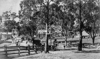
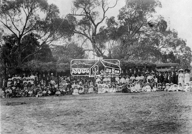
Negative - Photograph, Tom Prior (prob.), A peep at the picnickers, Eltham, c.1904
Reproduced ‘Pioneers & Painters’ pp 52-53. Picnickers enjoying a Sunday outing in the fields opposite Eltham Railway Station. Looking north towards Research along Main Road near the intersection with Dudley Street. Luther Hayley’s Bakery and General Store on left promoting refreshments and summer drinks. With the opening of the railway to Eltham in 1902, Melbourne residents would regularly enjoy a Sunday excursion journey on the train to Eltham for a day’s outing to the countryside. Possibly the annual State schools picnic held by the Board of Advice at Haley's Paddock near Eltham railway station on 11 March, 1904. Haley’s Paddock (now occupied by Eltham shopping centre) was capable of accommodating 10,000 people, with ample shade and hilly surroundings, an ideal place for any gathering. The main foreground is the site of the present day Eltham Village and Coles Shopping Centre. This photo forms part of a collection of photographs gathered by the Shire of Eltham for their centenary project book,"Pioneers and Painters: 100 years of the Shire of Eltham" by Alan Marshall (1971). The collection of over 500 images is held in partnership between Eltham District Historical Society and Yarra Plenty Regional Library (Eltham Library) and is now formally known as the 'The Shire of Eltham Pioneers Photograph Collection.' It is significant in being the first community sourced collection representing the places and people of the Shire's first one hundred years.Digital image 4 x 5 inch B&W Neg Print 20 x 25 cmshire of eltham pioneers photograph collection, eltham, main road, bakery, eltham village reserve, general store, haley's paddock, luther haley, luther haley general store, picnic, pioneers and painters, railway store, summer drinks -
 Eltham District Historical Society Inc
Photograph, Queenstown (St. Andrews); sports meeting Easter Monday on the Football reserve, c.1910
Note bush mia mia.This photo forms part of a collection of photographs gathered by the Shire of Eltham for their centenary project book,"Pioneers and Painters: 100 years of the Shire of Eltham" by Alan Marshall (1971). The collection of over 500 images is held in partnership between Eltham District Historical Society and Yarra Plenty Regional Library (Eltham Library) and is now formally known as the 'The Shire of Eltham Pioneers Photograph Collection.' It is significant in being the first community sourced collection representing the places and people of the Shire's first one hundred years.Digital image, 9 x 12.5 cm print and 4 x 5 inch B&W Negsepp, shire of eltham pioneers photograph collection, queenstown -
 Eltham District Historical Society Inc
Photograph - Photograph postcard, A peep at the picnickers, Eltham, c.1904
Postcards scanned from the collection of Michael Aitken on loan to EDHS, 13 Feb 2018 Reproduced ‘Pioneers & Painters’ pp 52-53. Picnickers enjoying a Sunday outing in the fields opposite Eltham Railway Station. Looking north towards Research along Main Road near the intersection with Dudley Street. Luther Hayley’s Bakery and General Store on left promoting refreshments and summer drinks. With the opening of the railway to Eltham in 1902, Melbourne residents would regularly enjoy a Sunday excursion journey on the train to Eltham for a day’s outing to the countryside. Possibly the annual State schools picnic held by the Board of Advice at Haley's Paddock near Eltham railway station on 11 March, 1904. Haley’s Paddock (now occupied by Eltham shopping centre) was capable of accommodating 10,000 people, with ample shade and hilly surroundings, an ideal place for any gathering. The main foreground is the site of the present day Eltham Village and Coles Shopping Centre. 1904 'STATE SCHOOLS' PICNIC.', Record (Emerald Hill, Vic. : 1881 - 1954), 19 March, p. 3. http://nla.gov.au/nla.news-article165173087Digital file only Postcards scanned from the collection of Michael Aitken on loan to EDHS, 13 Feb 2018michael aitken collection, postcards, eltham, main road, bakery, eltham village reserve, general store, haley's paddock, luther haley, luther haley general store, picnic, pioneers and painters, railway store, shire of eltham pioneers photograph collection, summer drinks -
 Eltham District Historical Society Inc
Photograph - Postcard, Rose Stereograph Company, View at Hurstbridge, Vic, c.1925
Rose Series Postcard P. 4341 “View at Hurstbridge, Vic.” Picnickers enjoying a Sunday outing near the Wattle Valley Estate at Hurstbridge. Copied from brochure "Wattle Valley Estate". It is believed the picture is taken at the northwest corner of the intersection of Wattletree Road and Hurstbridge-Arthurs Creek Road looking southeast towards the township (most likely where the house is located on the property of what is today No. 2 Wattletree Road)- https://goo.gl/maps/VDorwCe1rJJUapjE6 According to a comment by Jean Verso (via @nillumbikcouncil FB page 3 Jan 2020) - "This view is from Wattle Tree Road with Haleys Gully Road to the right and across the creek to William Gray's nursery at Allwood. The building to the far left looks like Dorset House. The building on the left in the middle distance is still there today and has been used for storage and as a stable/tack room for a number of years." The Wattle Valley Estate was first advertised in August 1925 as weekend building allotments by the Greater Melbourne Land and Development Company. Advertised from £28.10.0 or £60 per block. In August 1926, 30 picked allotments of 60x150 feet were put up for auction Saturday August 14, 1926 with frontages to Valley View Road and Fawkner Crescent advertised in the “Heart of the Glorious Wattle Country” and “Within 15 Minutes of the Newly Electrified Railway Station”. The Advertiser on August 13, 1926 in an article promoting the auction stated “the estate is regarded as one of the best in the district, and will be sold practically without reserve.” It is noted that an advertisement running in The Argus February 22, 1951 offered the remaining 16 blocks for sale at £12.10.0 or £200 the lot. By March 7, the remaining blocks were advertised at £17.10.0 The Wattle Valley Estate took over 20 years to sell and then people could not build on them Cross Ref SEPP_1057, “Popular Picnicing at Hurstbridge” rcopied from Wattle Valley estate sales brochure.Digital file only Postcards scanned from the collection of Michael Aitken on loan to EDHS, 13 Feb 20181925, dorset house, exhibition yprl 2019-12, fawkner crescent, haleys gully road, hurstbridge, hurstbridge-arthurs creek road, michael aitken collection, picnic, postcards, rose stereograph company, shire of eltham pioneers photograph collection, valley view road, wattle valley estate, wattletree road -
 Eltham District Historical Society Inc
Photograph - Postcard, The Bridge, Hurstbridge, Vic
Arched Bridge (Monash Bridge) The Rose Series P. 4036 Reproduced in a brochure advertising the "Wattle Valley Estate" 7 minutes from the bridge. The new bridge designed by Sir John Monash over the Diamond Creek near Hurst's original home "Mia Mia" seen in the distance. The Wattle Valley Estate was first advertised in August 1925 as weekend building allotments by the Greater Melbourne Land and Development Company. Advertised from £28.10.0 or £60 per block. In August 1926, 30 picked allotments of 60x150 feet were put up for auction Saturday August 14, 1926 with frontages to Valley View Road and Fawkner Crescent advertised in the “Heart of the Glorious Wattle Country” and “Within 15 Minutes of the Newly Electrified Railway Station”. The Advertiser on August 13, 1926 in an article promoting the auction stated “the estate is regarded as one of the best in the district, and will be sold practically without reserve.” It is noted that an advertisement running in The Argus February 22, 1951 offered the remaining 16 blocks for sale at £12.10.0 or £200 the lot. By March 7, the remaining blocks were advertised at £17.10.0 The Wattle Valley Estate took over 20 years to sell and then people could not build on them.Digital file only Postcards scanned from the collection of Michael Aitken on loan to EDHS, 13 Feb 2018michael aitken collection, postcards, hurstbridge, monash bridge, bridge, diamond creek (creek), mia mia, shire of eltham pioneers photograph collection, wattle valley estate -
 Marysville & District Historical Society
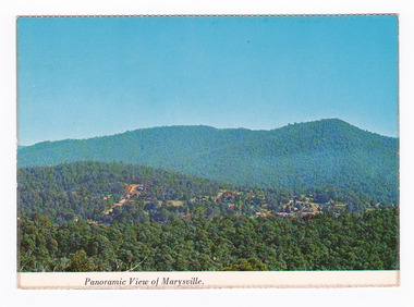
Postcard (item) - Colour postcard, Nucolorvue Productions Pty. Ltd, Panoramic View of Marysville, Pre 2009
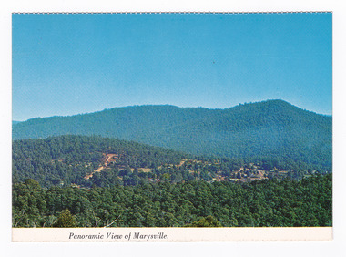
A colour photograph of the view of Marysville from Barton's Lookout which is near the Cumberland Valley in Victoria.A colour photograph of the view of Marysville from Barton's Lookout which is near the Cumberland Valley in Victoria. The Cumberland Valley is notable for its giant mountain ash (Eucalyptus regnans) trees within the Cumberland Memorial Scenic Reserve, and relics from former sawmills and gold mining. The Big Culvert is located nearby on the Marysville-Woods Point Road, which was historically part of the Yarra Track. Cambarville, which is in the Cumberland Valley, was established as a timber mill town in the 1940s. Timber mill owners A Cameron and FJ Barton named Cambarville. They established the mill to salvage timber from trees destroyed in the 1939 bushfires. Cambarville was impacted by the 2009 Black Saturday bushfires and any remaining structures were destroyed. Barton's Lookout was named after a member of the Barton Family who were amongst Marysville's earliest pioneering families. This postcard was produced by Nucolorvue Productions as a souvenir of Marysville.NU-COLOR-VUE/ OF/ AUSTRALIA MARYSVILLE, VICTORIA Panoramic View of Marysville from/ CUMBERLAND. PLACE/ STAMP/ HERE POST CARD NUC.171 - NUCOLORVUE PRODUCTIONS PTY. LTD./ COPYRIGHT Printed in Australiamarysville, barton's lookout, victoria, nucolorvue productions, postcard, souvenir, cumberland valley, cumberland memorial scenic reserve, big culvert, marysville-wood's point road, yarra track, mining, timber mills, a cameron, fj barton, cambarville, 1939 bushfires, 2009 black saturday bushfires -
 Marysville & District Historical Society
Postcard (item) - Colour postcard, Nucolorvue Productions Pty. Ltd, Panoramic View of Marysville, Pre 2009
A colour photograph of the view of Marysville from Barton's Lookout which is near the Cumberland Valley in Victoria.A colour photograph of the view of Marysville from Barton's Lookout which is near the Cumberland Valley in Victoria. The Cumberland Valley is notable for its giant mountain ash (Eucalyptus regnans) trees within the Cumberland Memorial Scenic Reserve, and relics from former sawmills and gold mining. The Big Culvert is located nearby on the Marysville-Woods Point Road, which was historically part of the Yarra Track. Cambarville, which is in the Cumberland Valley, was established as a timber mill town in the 1940s. Timber mill owners A Cameron and FJ Barton named Cambarville. They established the mill to salvage timber from trees destroyed in the 1939 bushfires. Cambarville was impacted by the 2009 Black Saturday bushfires and any remaining structures were destroyed. Barton's Lookout was named after a member of the Barton Family who were amongst Marysville's earliest pioneering families. This postcard was produced by Nucolorvue Productions as a souvenir of Marysville.NU-COLOR-VUE/ OF/ AUSTRALIA MARYSVILLE, VICTORIA Panoramic View of Marysville from/ CUMBERLAND. PLACE/ STAMP/ HERE POST CARD NUC.171 - NUCOLORVUE PRODUCTIONS PTY. LTD./ COPYRIGHT Printed in Australia Hi There! how are you? fine I hope....Hows school/ treating you?/ Isn't it beautiful now Autumns back again./ You'll have to come up soon and see us, where/ really you/ Ok! it beautiful, the air so fresh and/ clean it makes you want to cry. There are/ so many magnificent and brill marysville, barton's lookout, victoria, nucolorvue productions, postcard, souvenir, cumberland valley, cumberland memorial scenic reserve, big culvert, marysville-wood's point road, yarra track, mining, timber mills, a cameron, fj barton, cambarville, 1939 bushfires, 2009 black saturday bushfires -
 Eltham District Historical Society Inc
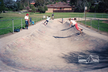
Photograph, The Snake Run, Bulleen Skatepark, Swanston Street Reserve, 96 Swanston Street, Bulleen, c.1985, 1985c
One of the pioneering skateparks in Victoria.Roll of 35mm colour negative film, 2 stripsFuji 100bullen skatepark, skate park, snake run -
 Eltham District Historical Society Inc
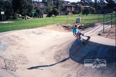
Photograph, The Snake Run, Bulleen Skatepark, Swanston Street Reserve, 96 Swanston Street, Bulleen, c.1985, 1985c
One of the pioneering skateparks in Victoria.Roll of 35mm colour negative film, 2 stripsFuji 100bullen skatepark, skate park, snake run -
 Federation University Historical Collection
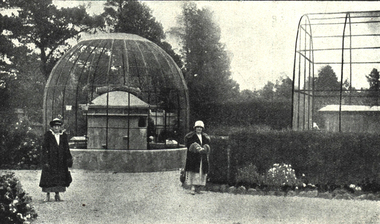
Photograph - Image, Scene in the Ballarat Zoological Gardens, c1923, c1923
In 1923 the Ballarat Zoo was open 2-5pm daily and 10-5 on Saturday. The entrance fee was 3 pence. When Ballarat pioneer citizen, Ben Jahan, died he left his fortune of nearly 11,000 pounds to the City of Ballarat for the purpose of establishing a zoo.Black and white image of the Ballarat zoo which was situated in the north-west corner of the Ballarat Botanical Gardens Reserve.ballarat zoo, ballarat zoological gardens, ballarat botanical gardens, ben jahn, parks and gardens -
 Federation University Historical Collection
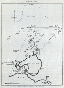
Image, Batman's Map of Port Phillip
Scanned from "The Old Pioneers' Memorial History of Melbourne From the Discovery of Port Phillip to the World War". It is a facsimile map from the House of Commons Reports of Committee.John Batman's map of Port Phillip showing Dutigalla (Batman's Tract), a township reserve, open plains, public common reserve, fresh water"A tract of country [called?] by the native chief of Southern Ausralia to be John Batman 6th June 1935."port phillip bay, john batman, melbourne, iramoo, r. sarsh, river sarsh, river batman, yarra river -
 City of Moorabbin Historical Society (Operating the Box Cottage Museum)
Photograph, 2 B&W, 1898 The O'Maras', Sandringham Fishermen : Date Unknown, Mud Brick House, 1898 The O'Maras', Sandringham Fishermen Date Unknown, Mud Brick House, 1898
The O'Maras, of Sandringham fishermen. Early mud brick house. Located in Moorabbin and was still there in 1940. The house was situated in Reserve Road, almost opposite Wangara Road, (formerly Cemetery Road). About twelve years ago, (* the writer states no year), there was a vacant block where the house used to be - it was next to a electrical factory. 2x Black and White Photographs. (i) An 1898 photograph showing two men with a fishing boat on the beach. A beach house / shed , paling fence and tall tea-trees are seen in the background. (ii) A large early mud brick house with a tin roof, chimney and a water tank sitting on a block of grassed landWritten on back (i) The O'Maras / Sandringham / fishermen 1898 (ii) Mud brick house at Moorabbin ( house was there in 1940) / Situated in Reserve Road almost opposite Wangara Road / ( formerly Cemetery Road ). About 12 years ago there was a vacant block where the house used to be and it was next to an electrical factory. unsigned undatedthe o'maras, sandringham fisherman, 1898, mud brick house, moorabbin, wangara road, reserve road, electrical factory, early settlers, pioneers, shire of moorabbin, sandringham, beaumaris, mentone, fishermen, dairy farmaers, poultry farmers, market gardeners, -
 City of Moorabbin Historical Society (Operating the Box Cottage Museum)
Photograph (collection) - Bentleigh Recreational Reserve, Gathering of East Bentleigh Residents, c 1915
bentleigh, city of moorabbin, bentleigh recreational reserve, william burgess, fundraising, volunteers, sportbentleigh, city of moorabbin, bentleigh recreational reserve, william burgess, fundraising, volunteers, sport -
 City of Moorabbin Historical Society (Operating the Box Cottage Museum)
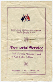
Programme - Memorial Service - Bentleigh Recreation Reserve, Unveiling Memorial Tablet to Our Fallen Soldiers, 1918
The memorial service held at the Bentleigh Recreation Reserve on Sunday, December 8, 1918. It was largely attended. The president of the Sire, Cr. D. White, was introduced to those present, by Cr T Marriott. Mr O. R. Snowball, M.L.A., unveiled the memorial tablet, which was inscribed as follows :-- “To the memory of Bentleigh boys who died for their country in the Great War 1914.18,. Greater love hath no Man than this, that a man lay down his life for his friends.” OUR FALLEN HEROES Austin, R J, (M.M.); Mitchell, R A; Baker, O R; Manfield G S; Bevis, D E; Norris, H; Crutchfield, C; Odgen, A.; Dodson, H E; Perry, L.; Dunigan, F J; Sharpin, G; Hill, G; Searle, J H; Jones, C; Smith, E R Bentleigh residents remembers the "Bentleigh Boys" that were killed in World War One, the sons of pioneer familiies of the districtFour page Programme, for the Memorial Service and unveiling of memorial Table to the Shire of Moorabbin's fallen Soldiers.world war one, wwi, memorial, bentleigh recreation reserve, moorabbin, bentleigh, shire of moorabbin, austin, mitchell, baker, manfield g s, bevis, norris, crutchfield, odgen, perry, dunigan, sharpin, hill, searle, smith, dodson -
 Bendigo Historical Society Inc.
Document - MINE SAFETY CAGES & FEDDER DUSTER
Three pages of extracts titled Mine Safety Cages, Old Bendigonians, memories of 'Fedder Duster', a Chinese Market Gardener; and a book review. The Safety Cage was an invention to stop the cage falling down the shaft if the rope gave way. Fedder Duster was a Chinese Market Gardener who was forced off his garden lease. His name was Ah Louey. The Book Review was 'Land, Labour and Gold' or Two Years in Victoria, with visits to Sydney and Van Diemen’s Land, by William Howitt.document, names of bendigo pioneers, mine safety cages & fedder duster, tasmanian foundry, mr j h seymour, dr stewart, conflecua mine malmsbury, thomas dunne, mr frank fitzpatrick, mr a llewellun, old bendigonians, mr john robshaw, mr hugh mcdevitt, alexander bayne, mr f sciallero, camp reserve, art gallery, hon. w i winter-irvine, george avery fletcher, great central goldfield, dear old bendigo 1892, fedder duster, mrs chancellor, ah louey, market gardener, mr curnow, technical school art class, bendigo benevolent home, joch, land labour and gold 1855, two years in victoria with visits to sydney and van diemen's land, william howitt, lowden publishing co, government camp, stars & stripes of america, odd fellows, freemasons, miss f kingerlee -
 Bendigo Historical Society Inc.
Document - NOTES FOR RHSV BENDIGO BRANCH NEWSLETTER ''BENDIGO MEMORIES, 1860 TO 80''
Notes for Aug. 1973 RHSV Bendigo Branch Newsletter ''Bendigo Memories, 1860 -80'' by G Meudell, author of ''The pleasant reflections of a spend thrift and his later reflections'', article submitted by Mr R Buick - continuation of this article in the Nov 1973 issue (see Mosaic #6544) - reference to George Lansell; Baranet Lazarus; William Hunter; Joseph Hunter; Robert Hunter; Burnewang Park; William Moffat; Andrew O'Keefe; David Grant; Thomas Luxton; James Vickery; James Taylor; Jim Maddox; Cocky Brown (caretaker of Camp Reserve); W D C Donovan; Eureka Stockade. 2. Article entitled ''Looking Back'' by Joch - re Historical Societies of Bendigo - mention of a long list of Bendigo names involved with the early Society and a call for readers of the article to research and record the History of Bendigo!!!document, names of bendigo pioneers, bendigo -
 Bendigo Historical Society Inc.
Document - LANSELL RELATED DOCUMENTS
Document.Copy of Williamstown Historical Society Newsletter No 17 (1977).On the second and third page of this Newsletter is an article entitled ''The guns of the 'Nelson''', written by Doug Mills, Castlemaine. The Warship NELSON underwent alterations in 1860, including cut down to two decks and lengthened, her armaments reduced to 72 guns. Two 7inch 68 pounder guns were added to her armament. In February 7 1867 she was officially given to the Colony of Victoria by the Imperial Government. At the time her Commander was Captain Charles B. Payne. The Warship reached Melbourne in 4th February 1868. Relics of the NELSON were auctioned at Williamstown Victoria Naval Depot, and her two anchors are preserved for public display at Williamstown. An active demand for a share of the guns from various towns in the State. Ballarat received four (4) guns, Bendigo and Castlemaine two (2) each, while one has been given to each of the following towns: - Ararat, Tarnagulla, Hamilton, Bacchus Marsh, Echuca and Geelong. Collection of Lansell related documents: a. Copy of photograph - Lansell's Big 180 Victoria Hill - early 1870s - New Chum Hill in background. B. Lansell Estate mines - compiled from the annual report of the Hon Minister of Mines for Victoria, 1906. A listing of the George Lansell Mining Company interests at the time of his death. These were, New Moon Co, N.L., Clarence, New Prince Of Wales Co. N.L., Virginia G. M. Co., Catherine Reef United Co N.L., Great Northern Co N.L., Williams United, McDuff Amalgamated Co, South Mungo Co, South Prince Of Wales Consolidated, Constellation Co. Golden Pyke Co, Johnson's Reef Extended Company, Golden Age Co., Princess Dagmar Co, New St Mungo Co, Johnson's Reef Co, North Johnson's Co, Collman and Tacchi Co, Confidence Extended Co, G. Lansell Sandhurst Mines, Pearl Co., Windmill Hill Co., United Hustlers and Redan, Koch's Pioneer Co., Hercules and Energetic Co., Lansell's Comet, Cornish United Co., Ironbark Co., Hustler's Reef Co., and No. 1 Lansell's 83, Carlisle Co., Great Extended Hustler's Co., Victoria Consolidated Co., Great Central Victoria Co., Victoria Quartz Co., Victory and Pandora , Lansell's Big 180, Tambour Major, New Chum and Victoria Co., Garden Gully United Co., G. Lansell, Lansell's 222, Lazarus Co., Sea Amalgamated Co., Hustler's Royal Reserve Co., Horwood and Burrowe's Co., New Chum Consolidated Co., G Lansell's Sheepshead, Gariboldi Co., Londonderry Co., Shamrock Co., Great Britain Co., Fortuna Hustler's Co., Eureka Extended Co., G. Lansell's G.V.L., New Red White and Blue Consolidated, Great Southern Co., Lansell's Concord Mines, True Blue Co., G. G. Consolidated Co., Extended Red White and Blue Co., Great Columbian, Sedgwick and New Birthday. Also, a listing: ''Among the biggest yields to ate (sic) (date?) in ozs or Pounds were''; New Moon.Co. N.L. 180,087 ounces, Clarence £303,932, Catherine Reef United N.L. £762,815, Great Northern Co Ltd £394,525, Johnson's Reef Co 277,320ounces, Windmill Hill Co. 113,842ounces, Hustler's Reef Co. And No.1 1,144,923ounces, Carlisle Co 307,835ounces, Great Extended Hustlers Co £1,038,125, Garden Gully United Co. £1,653,900, Great Southern 97,752ounces, New Chum Consolidated 89,526ounces. This part (b) has handwritten inscription ''compiled by J Sarvaas MCE(??) Certified Mining Surveyor; 22/8/06''; c. Copy of Deed dated Dec 1886 between George Lansell, Wooten Lansell and the Bank of New South Wales relating to a wall and windows and openings etc etc. (3 pages of legalese!!!!!). Also, a (related?) page copy of a Grant -by purchase to the Bank of New South Wales with a date of August 1855 on it ''Enrolled in the Office of the Registrar of the Supreme Court of the Colony of Victoria - signed by Acting Registrar.document, gold, mines -
 Whitehorse Historical Society Inc.
Letter - Correspondence, Nunawading Park Tennis Club, 1983
Letter to the editor, Nunawading Gazette, from Alan Macgillicuddy Figgis about the history of Nunawading Park Tennis Club formed 1919.Letter to the editor, Nunawading Gazette, from Alan Macgillicuddy Figgis about the history of Nunawading Park Tennis Club formed 1919. It was located corner of Canterbury and Middleborough Roads and is now incorporated in the R.H.L. Sparks Reserve. Alan was a foundation member of the club. Also describes his work with the E.S. & A. Bank pioneering agencies in the district.Letter to the editor, Nunawading Gazette, from Alan Macgillicuddy Figgis about the history of Nunawading Park Tennis Club formed 1919. tennis, nunawading park tennis club, figgis, alan, r.h.l. sparks reserve, banks, english, scottish and australian bank -
 Whitehorse Historical Society Inc.
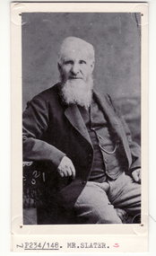
Photograph, William Slater
Mrs Slater and her husband William Slater migrated from Mitcham, Surrey, England in 1855 and established a herb farm in Nunawading - the first in Victoria. The farm was located in Blackburn Road, North Blackburn. When Mrs Slater died in 1895 the farm was sold. Slater Avenue and Slater Reserve is named for them.4 copies of black and white photo of William Slaterpioneers, slater, william, herb farms, slater avenue, blackburn north, slater reserve -
 Whitehorse Historical Society Inc.
Photograph, Slaters Cottage - Original Cottage, 1/08/2009 12:00:00 AM
See the following relating Slater & the Reserve NP2000, 3558, 4396, 5141 & 5824.Coloured Photograph of the original cottage built by William Slater Jnr the son of William Henry Slater the pioneer involved in the establishment of the early herb and lavender farm in this district.|Note that the house was being renovated. It is on the Heritage Overlay of the Cityslater william, slater william jnr, surrey road blackburn north no 106, heritage overlay -
 Ballarat Tramway Museum
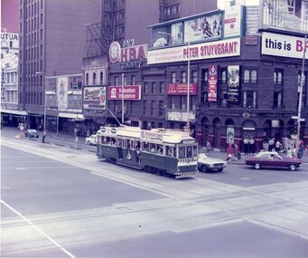
Photograph - Colour Photocopy/photocopies, John Phillips, 28/01/1980 12:00:00 AM
Yields information about the operation of a Ballarat (ex Melbourne) tram in Melbourne during an Australia Day celebrations by the BTPS and the city skyline at the time.Colour photograph of BTM Ballarat Tram No. 40 at the corner of Swanston St and Flinders St. Melbourne on 28 Jan. 1980. Tram fitted with Pioneer Settlement and Peters Ice Cream Roof Ads, showing Sebastopol destination. Taken during the Australia Day celebrations. Young & Jackson Hotel in the background with many advertisements. Photo taken from the Princes Bridge Station Plaza. Taken by John Phillips. Second copy added 9/11/2005 to display box D2. See also Reg Item 4131 and 4132 for other photos of the day - Wellington Parade. See 1979-1980 Annual Reportaustralia day, melbourne, btps, tram 40 -
 Ballarat Tramway Museum
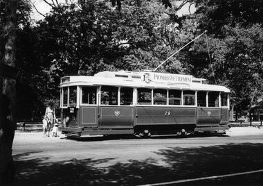
Photograph - Black & White Photograph/s, William. F. Scott, c1990
Black and White Photograph of Ballarat No. 28 in BTM Service, Wendouree Parade, picking up passengers, north bound at Depot Junction. Taken by William F. Scott. Taken c1990. Fitted with Pioneer Settlement sign. On Agfa paper.On rear in bottom left hand corner on a label - stamped "William F. Scott" in black ink and "T19 31A" written in black ink.trams, tramways, btm, 28, passengers, wendouree parade, tram 28 -
 Ballarat Tramway Museum
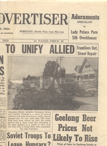
Newspaper, Geelong Advertiser, "Tramlines out, street repair", "Vandal damage tram to become scrap", 27/10/1959 12:00:00 AM
Newspaper clipping from the Geelong Advertiser, 27/10/1959. Page 1 - top right hand corner, article and photograph - "Tramlines out, street repair", of the removal of tram track in Aberdeen Street between Pakington Street and Latrobe St. Page 2 - top right hand corner, article and photograph - "Vandal damage tram to become scrap" - about the decision by the Newtown and Chilwell Council to give the tram in Queens Park to the 3rd Geelong Flinders Pioneers as scrap metal. Tram No. 38. Contained originally within Reg Item 5623 at the front of this note book. For items see btm5623 loose items list.pdf.geelong, closure, track removal, preserved trams, queens park -
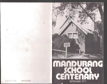 Bendigo Historical Society Inc.
Book - JOHN JONES COLLECTION: MANDURANG SCHOOL CENTENARY SEPTEMBER 1977, September 1977
Small booklet titled Mandurang School Centenary September 1977. It has a black and white picture of the school on the front cover. Mentioned in the book is the History of Mandurang State School and District, Industries, Wine, Milk, Gold, Tannery, The Look-Out, Timber, Hotels, Water Race, Floods, Post Office, Sports, Churches, Fire Brigade, List of Head Teachers 1861 - 1975, The School opens 1877 and Mothers' Club. Photos include Mr & Mrs J T Deravin Pioneer settlers of Mandurang, Deravin's Barn & Wine Cellars, Bernado Togno's Vineyard, Hargreave's Milk Cart, J Pearce & Sons Milk Delivery Bike, The Tannery, Wooden Poppet Head Tower, Kerr's Hotel, The Wine Hall (Previously Junction Hotel), Harry & Len Kofoed's Wood Trucks, Mandurang Recreation Reserve 1977, Mandurang Cricket Club (1889 or thereabouts), Methodist Church, School Pupils 1894, Early School Group, School Pupils 1960 and 1962, Working Bee before shifting School Building to it's Present Site, School Pupils 1922 and School Pupils 1977.Edwin J. Watts. Express Print, Bendigoeducation, primary, mandurang primary school no 1952, john jones collection - mandurang school centenary september 1977, edwin j watts, kevin o'brien, g pearce, j sloan, v togno, r pearce, j french, i adams, b adams, g grose, i kofoed, j pearce, f pentland, g shaw, n todd, i grose, h koefoed, m macdonald, k pearce, t french