Showing 84 items
matching places - bakery hill
-
 Ballarat Heritage Services
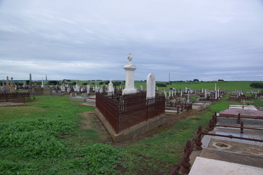
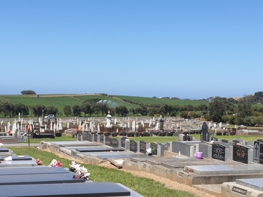
Photograph - Photograph - Colour, Clare Gervasoni, Tower Hill Cemetery, 2009, 26/07/2009
The Tower Hill Cemetery is located near Koroit on the north side of the Princes Highway The, between Port Fairy and Warrnambool. The first burial at Tower Hill Cemetery took place in 1856. Over 150 years there has been over 8,000 burials. Around 45 percent of the burials are in unmarked graves.Colour photograph of a headstone in the Tower Hill Cemetery.tower hill cemetery, william rutledge, eliza rutledge -
 Ballarat Heritage Services
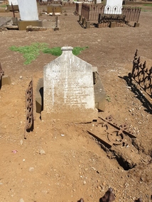
Photograph - Photograph - Colour, Clare Gervasoni, Tower Hill Cemetery, 2009, 26/07/2009
The Tower Hill Cemetery is located near Koroit on the north side of the Princes Highway The, between Port Fairy and Warrnambool. The first burial at Tower Hill Cemetery took place in 1856. Over 150 years there has been over 8,000 burials. Around 45 percent of the burials are in unmarked graves.Colour photograph of a headstone in the Tower Hill Cemetery.tower hill cemetery -
 Ballarat Heritage Services
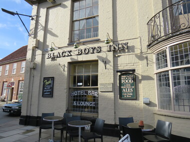
digital photographs, Inn, Aylesham, England, 2016
Black Boys Inn is in the market square of Aylesham, England. "Archaeological evidence shows that the site of the town has been occupied since prehistoric times. Aylsham is just over two miles (3 km) from a substantial Roman settlement at Brampton, linked to Venta Icenorum at Caistor St Edmund, south of Norwich, by a Roman road which can still be traced in places - that site was a bustling industrial centre with maritime links to the rest of the empire. Excavations in the 1970s provided evidence of several kilns, showing that this was an industrial centre, pottery and metal items being the main items manufactured. Aylsham is thought to have been founded around 500 AD by an Anglo Saxon thegn called Aegel, Aegel's Ham, meaning "Aegel's settlement". The town is mentioned in the Domesday Book of 1086 as Elesham and Ailesham, with a population of about 1,000. Until the 15th century, the linen and worsted industry was important here, as well as in North Walsham and Worstead and Aylsham webb or 'cloth of Aylsham' was supplied to the royal palaces of Edward II and III. John of Gaunt was lord of the manor from 1372 and Aylsham became the principal town of the Duchy of Lancaster. Although John of Gaunt probably never came to Aylsham, the townspeople enjoyed many privileges, including exemption from jury service outside the manor and from payment of certain taxes. The village sign depicts John of Gaunt. In 1519 Henry VIII granted a market on Saturdays and an annual fair to be held on 12 March, which was the eve of the feast of St Gregory the pope. Aylsham markets have always been an important feature of the town, and businesses developed to meet the needs of the town and the farming lands around it. Besides weekly markets there were cattle fairs twice a year and, in October, a hiring fair. The historic Black Boys Inn in the Market Place is one of Aylsham's oldest surviving buildings, and has been on the site since the 1650s, although the present frontage dates to between 1710 and 1720. There is a frieze of small black boys on the cornice and a good staircase and assembly room. The Black Boys was a stop for the post coach from Norwich to Cromer, had stabling for 40 horses, and employed three ostlers and four postboys. A thatched waterpump was built in 1911 at Carr's Corner in memory of John Soame by his uncle, a wealthy financier. An artesian well 170 feet (52 m) deep, its canopy is thatched in Norfolk reed. As with many of the other market towns in the county, the weaving of local cloth brought prosperity to the town in medieval times. Until the 15th century it was the manufacture of linen which was the more important, and Aylsham linens and Aylsham canvases were nationally known. From the 16th century linen manufacture declined and wool became more important, a situation that continued until the coming of the Industrial Revolution. Thereafter the principal trade of the town for the 19th century was grain and timber, together with the range of trades to be found in a town which supported local agriculture. Records show that Aylsham had markets and fairs, certainly from the 13th century. Such weekly and annual events were important for the trade that they brought. Annual horse fairs would bring many other traders to the town, and the weekly market would be the occasion for more local trade. The rights of the stallholders in the market place today date back to the rights established in medieval times." See wikipediaDigital photograph colouredinn, aylsham, england, black boys inn, market square -
 Ballarat Heritage Services
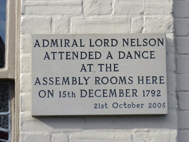
Photograph - Digital photograph, Lord Nelson Plaque, 2016
Black Boys Inn is in the market square of Aylsham, England. "Archaeological evidence shows that the site of the town has been occupied since prehistoric times. Aylsham is just over two miles (3 km) from a substantial Roman settlement at Brampton, linked to Venta Icenorum at Caistor St Edmund, south of Norwich, by a Roman road which can still be traced in places - that site was a bustling industrial centre with maritime links to the rest of the empire. Excavations in the 1970s provided evidence of several kilns, showing that this was an industrial centre, pottery and metal items being the main items manufactured. Aylsham is thought to have been founded around 500 AD by an Anglo Saxon thegn called Aegel, Aegel's Ham, meaning "Aegel's settlement". The town is mentioned in the Domesday Book of 1086 as Elesham and Ailesham, with a population of about 1,000. Until the 15th century, the linen and worsted industry was important here, as well as in North Walsham and Worstead and Aylsham webb or 'cloth of Aylsham' was supplied to the royal palaces of Edward II and III. John of Gaunt was lord of the manor from 1372 and Aylsham became the principal town of the Duchy of Lancaster. Although John of Gaunt probably never came to Aylsham, the townspeople enjoyed many privileges, including exemption from jury service outside the manor and from payment of certain taxes. The village sign depicts John of Gaunt. In 1519 Henry VIII granted a market on Saturdays and an annual fair to be held on 12 March, which was the eve of the feast of St Gregory the pope. Aylsham markets have always been an important feature of the town, and businesses developed to meet the needs of the town and the farming lands around it. Besides weekly markets there were cattle fairs twice a year and, in October, a hiring fair. The historic Black Boys Inn in the Market Place is one of Aylsham's oldest surviving buildings, and has been on the site since the 1650s, although the present frontage dates to between 1710 and 1720. There is a frieze of small black boys on the cornice and a good staircase and assembly room. The Black Boys was a stop for the post coach from Norwich to Cromer, had stabling for 40 horses, and employed three ostlers and four postboys. A thatched waterpump was built in 1911 at Carr's Corner in memory of John Soame by his uncle, a wealthy financier. An artesian well 170 feet (52 m) deep, its canopy is thatched in Norfolk reed. As with many of the other market towns in the county, the weaving of local cloth brought prosperity to the town in medieval times. Until the 15th century it was the manufacture of linen which was the more important, and Aylsham linens and Aylsham canvases were nationally known. From the 16th century linen manufacture declined and wool became more important, a situation that continued until the coming of the Industrial Revolution. Thereafter the principal trade of the town for the 19th century was grain and timber, together with the range of trades to be found in a town which supported local agriculture. Records show that Aylsham had markets and fairs, certainly from the 13th century. Such weekly and annual events were important for the trade that they brought. Annual horse fairs would bring many other traders to the town, and the weekly market would be the occasion for more local trade. The rights of the stallholders in the market place today date back to the rights established in medieval times." See wikipediaDigital photograph"Admiral Lord Nelson attended a dance at the Assembly rooms here on 15th December 1792 - 21st October 2005"aylsham, lord nelson, 1792, plaque -
 Ballarat Heritage Services
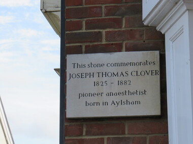
Photograph - Digital photograph, Dorothy Wickham, Plaque to Joseph Thomas Clover, ć2016
Lord Nelson plaque is in the town of Aylsham. "Archaeological evidence shows that the site of the town has been occupied since prehistoric times. Aylsham is just over two miles (3 km) from a substantial Roman settlement at Brampton, linked to Venta Icenorum at Caistor St Edmund, south of Norwich, by a Roman road which can still be traced in places - that site was a bustling industrial centre with maritime links to the rest of the empire. Excavations in the 1970s provided evidence of several kilns, showing that this was an industrial centre, pottery and metal items being the main items manufactured. Aylsham is thought to have been founded around 500 AD by an Anglo Saxon thegn called Aegel, Aegel's Ham, meaning "Aegel's settlement". The town is mentioned in the Domesday Book of 1086 as Elesham and Ailesham, with a population of about 1,000. Until the 15th century, the linen and worsted industry was important here, as well as in North Walsham and Worstead and Aylsham webb or 'cloth of Aylsham' was supplied to the royal palaces of Edward II and III. John of Gaunt was lord of the manor from 1372 and Aylsham became the principal town of the Duchy of Lancaster. Although John of Gaunt probably never came to Aylsham, the townspeople enjoyed many privileges, including exemption from jury service outside the manor and from payment of certain taxes. The village sign depicts John of Gaunt. In 1519 Henry VIII granted a market on Saturdays and an annual fair to be held on 12 March, which was the eve of the feast of St Gregory the pope. Aylsham markets have always been an important feature of the town, and businesses developed to meet the needs of the town and the farming lands around it. Besides weekly markets there were cattle fairs twice a year and, in October, a hiring fair. The historic Black Boys Inn in the Market Place is one of Aylsham's oldest surviving buildings, and has been on the site since the 1650s, although the present frontage dates to between 1710 and 1720. There is a frieze of small black boys on the cornice and a good staircase and assembly room. The Black Boys was a stop for the post coach from Norwich to Cromer, had stabling for 40 horses, and employed three ostlers and four postboys. A thatched waterpump was built in 1911 at Carr's Corner in memory of John Soame by his uncle, a wealthy financier. An artesian well 170 feet (52 m) deep, its canopy is thatched in Norfolk reed. As with many of the other market towns in the county, the weaving of local cloth brought prosperity to the town in medieval times. Until the 15th century it was the manufacture of linen which was the more important, and Aylsham linens and Aylsham canvases were nationally known. From the 16th century linen manufacture declined and wool became more important, a situation that continued until the coming of the Industrial Revolution. Thereafter the principal trade of the town for the 19th century was grain and timber, together with the range of trades to be found in a town which supported local agriculture. Records show that Aylsham had markets and fairs, certainly from the 13th century. Such weekly and annual events were important for the trade that they brought. Annual horse fairs would bring many other traders to the town, and the weekly market would be the occasion for more local trade. The rights of the stallholders in the market place today date back to the rights established in medieval times." See wikipediaDigital photograph"This stone commemorates JOSEPH THOMAS CLOVER 1825-1882 pioneer anaesthetist born in Aylsham"aylsham, joseph thomas clover, anaesthetist -
 Ballarat Heritage Services
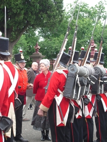
Photograph - Eureka Commemoration at the Ballaarat Old Cemetery, Cr Judy Verlin inspects the 40th Regiment reenactors on Eureka Sunday 2008, 12/2008
Two colour photographs of inspection of the 40th Regiment by Cr Judy Verlin. The event took place on Eureka Sunday in the Ballaarat Old Cemetery. Doug Sera is seen in the background,eureka stockade, eureka sunday, 40th regiment, ballaarat old cemetery, commemoration -
 Ballarat Heritage Services
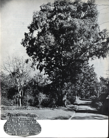
Photograph - Image, Separation Tree, Melbourne, c1951
The Colony of Victoria separated from New South Wales on 01 July 1851.Photograph of Melbourne's Separation TreeSeparation Tree' Under this tree on 15th November 1850 public rejoicings of citizens of Melbourne took place in Celebration of the Colony of Victoria from New South Wales on 1st July 1851.victoria, melbourne, separation tree, colony of victoria -
 Ballarat Heritage Services
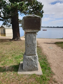
Photograph - Boathouse, Clare Gervasoni, Cairn displaying the place were William Cross Yuille Camped, 2021
Lake Wendouree was originally known as Yuille's Swamp.Colour photograph of a cairn displaying the place were William Cross Yuille CampedNear this spot was the camp of the first resident of Ballarat William Cross Yuille in March 1938. Presented by Cr A.J. Darling. Mayor of Ballarat 1034. Ballt Historical Socylake wendouree, william cross yuille, a.j. darling, yuille's swamp, marker -
 Ballarat Heritage Services
Photograph, Clare Gervasoni, Victory House, Geelong Road, Canadian, 2023, 2023
Victory House, named after the 1902 Melbourne Cup winner The Victory, was built in 1906 near goldmines and was home to the family of Chinese goldmine manager James Wong Chung. The Chung family lived in the Geelong Road home until 2008, when it was sold. The home was widely known as a welcoming place that hosted large gatherings of Chinese people to celebrate culture and heritage. It is recognised for its strong links to Ballarat's goldrush history and Chinese history in Ballarat. Colour photographs of Victory House in Main Road Ballarat East.victory house, chinese, ballarat, james wong chung, canadian -
 Ballarat Heritage Services
Film - Video, Clare Gervasoni, Lal Lal Waterfall, 15/10/2022
Lal Lal Waterfall is situated in the Lal Lal Reserve. It has an impressive drop into a rocky gorge. Culturally, the Falls are believed to be the earthly home of Bunjil, the All Father or Creator to most Victorian Aboriginal tribes. The name Lal Lal is thought to be Aboriginal for "dashing of waters". The Lal Lal Falls is listed on the Site Registry of Aboriginal Affairs Victoria as a spiritual place.Video of the Lal Lal Waterfall after heavy rain.lal lal, lal lal waterfall -
 Ballarat Heritage Services
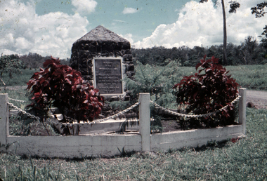
Slide, Dorothy Wickham, Kokoda Trail Monument, Papua New Guinea, 1958
The Kokoda Trail or track is a place of historic significance to many Australians. It is outside Australia in Papua New Guinea.Scanned from a coloured slideView from this sidepapua new guinea, papuan, kokoda, kokoda trail, military, soldiers, fuzzy wuzzy angels -
 Ballarat Heritage Services
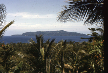
Slide, Dorothy Wickham, Scene, Papua New Guinea, 1958
The Kokoda Trail or track is a place of historic significance to many Australians. It is outside Australia in Papua New Guinea.Scanned from a coloured slideView from this sidepapua new guinea, papuan, scene -
 Ballarat Heritage Services
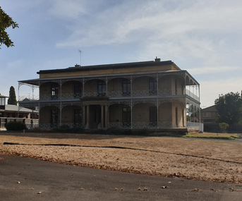
Photograph - Colour, Clare Gervasoni, Armytage House, Geelong, 2019, 24/03/2019
'Armytage House' formerly 'The Hermitage' a two storey Barrabool freestone ashlar and basalt rubble mansion was upon completion in 1860 one the finest colonial regency style mansion houses in Victoria. The Ionic portico and exquisitely proportioned, encircling wrought iron verandah is the most distinctive feature of this mansion, which is undoubtedly Edward Prowse's most impressive work. The mansion has considerable and important historical associations, firstly with the Armytage family, and finally with the Geelong C.E.G.G.S (1905-1973) (https://vhd.heritagecouncil.vic.gov.au/places/21747/download-report, accessed 25/03/2019) 03 May 1858 - Tender Notice in Geelong Advertiser 27 April 1860 - tender for iron gates 15 October 1860 - tender for stone wall and iron railing.armytage, armytage house, geelong, edward prowse, barrabook freestone, the hermitage -
 Ballarat Heritage Services
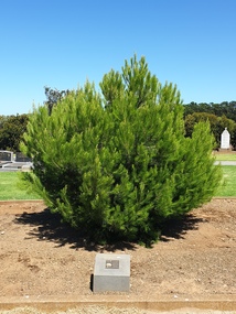
Photograph - Photograph - Colour, Clare Gervasoni, Aleppo Pine, Tower Hill Cemetery, 2019, 03/01/2019
The Tower Hill Cemetery is located near Koroit on the north side of the Princes Highway The, between Port Fairy and Warrnambool. The first burial at Tower Hill Cemetery took place in 1856. Over 150 years there has been over 8,000 burials. Around 45 percent of the burials are in unmarked graves. In 2023 this tree was no longer in existence, and a smaller tree was struggling in this site.Colour photographs of an Aleppo Pine planted in the Tower Hill Cemetery to mark the centenary of the landing at Galipolli.aleppo pine, anzac centenary, centenary, anniversary, tower hill cemetery, gallipoli -
 Ballarat Heritage Services
Photograph - Photograph - Colour, Clare Gervasoni, Tower Hill Cemetery, 2019, 03/01/2019
The Tower Hill Cemetery is located near Koroit on the north side of the Princes Highway The, between Port Fairy and Warrnambool. The first burial at Tower Hill Cemetery took place in 1856. Over 150 years there has been over 8,000 burials. Around 45 percent of the burials are in unmarked graves. Colour photograph of the Tower Hill Cemetery. with potatoes being irrigated in te background. The cemetery is laid out on design of a Celtic Cross.tower hill cemetery, tower hill, cemetery -
 Ballarat Heritage Services
Photograph - Photograph - Colour, Clare Gervasoni, Headstone of Patrick Carroll in Tower Hill Cemetery, 2019, 03/01/2019
The Tower Hill Cemetery is located near Koroit on the north side of the Princes Highway The, between Port Fairy and Warrnambool. The first burial at Tower Hill Cemetery took place in 1856. Over 150 years there has been over 8,000 burials. Around 45 percent of the burials are in unmarked graves.Colour photograph of the headstone of Patrick Carroll in the Tower Hill Cemetery. . by Patrick Carroll InLoving Remembrance of my beloved son Patrick Who departed this life the 20th day of April 1874 Aged 2 years and 2 months Also his beloved mother Who departed this life 15th Sept 1876 Aged 74 years Also his who died 16th November 1890 Aged 89 Years Also Patrick Carroll Who died 10 July 1906 aged 72 years Rest in Peace tower hill cemetery, patrick carroll -
 Ballarat Heritage Services
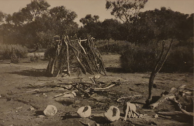
Photograph - Image, "A Native Burial Place (Weeping Caps in Foreground), c1918, c1918
A burial place, surrounded with bark. central australia, aborigines, aboriginal burial place, burial caps, aboriginal -
 Ballarat Heritage Services
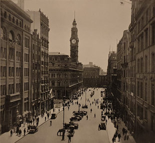
Image, Martin Place, Sydney, c1918, c1918
martin place, sydney gpo -
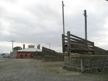 Ballarat Heritage Services
Photograph, L.J. Gervasoni, Cattle Race at the Ballarat Saleyards, 2008, 27/06/2008
The last sale at the Delacombe Saleyards took place in December 2018. The closure comes after around 130 years after the parcel of land that is home to the Ballarat saleyards was permanently reserved from sale by then Colony of Victoria Governor, Sir Henry Brougham Loch, with advice of the Executive Council.Colour photographs of the Ballarat Sale yards, LaTrobe Street, Delacombe. ballarat saleyards, saleyards, cattle yards, cattlerace, agriculture -
 Ballarat Heritage Services
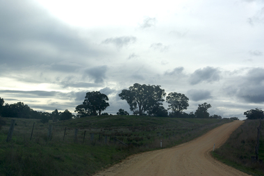
Photograph - Photograph - Colour, Clare Gervasoni, Tarilta, 2017, 16/07/2017
Tarilta is a rural locality and former gold-mining town 12 km south of Castlemaine, 4 km north-west of Guildford and 3 km north-east of Vaughan. The last gold mining activity took place around the 1880s. It was originally Kangaroo Flat, being located where the Kangaroo Creek enters the Loddon River. It was surveyed and named in 1864. Gold was discovered at Tarilta in 1853. The Tarilta School was opened in 1860 in a Wesleyan chapel, and closed i n1925. In 1864 a township was surveyed and named Tarilta, the word being derived from an Aboriginal expression thought to mean kangaroo. In 1865 Bailliere’s Victorian gazetteer described Tarilta as being an alluvial and quartz gold-mining town with three quartz-crushing mills, three horse-puddling machines and two hotels. The elevated nature of the land around Tarilta made it accessible only by horse and dray, or on horseback. Colour photograph of Tarilta in Central Victoria. tarilta, central victoria, landcape -
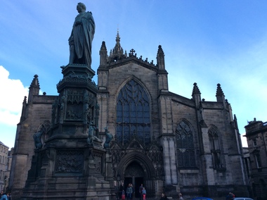 Ballarat Heritage Services
Digital Photograph, St Giles Cathedral, Edinburgh, Scotland, 10/2016
St Giles, also known as the High Kirk of Edinburgh is the principal place of worship for the Church of Scotland. It is very interesting for the mason's marks found on its many stone columns inside the church, and for its connections to the graveyard outside. According to wikipedia, "There is record evidence of a church here, very likely on the present site, in the year 854. In 1120 King Alexander I, rebuilt the church in the Norman style. Of this building characteristic features survived until 1798. During the fourteenth century, Edinburgh was captured and plundered by the English under Edward II. and Edward III., and twice St Giles was laid waste. After restoration, the church was more thoroughly ruined at the Burnt Candlemas in 1387, when Richard II. sacked the city. The western part of the fabric was soon in use again ; but the restoration of the choir and transepts, which were much enlarged, lasted on into the sixteenth century. In 1467 the city endowed St Giles as a collegiate church. It now became usual to speak of the nave, where the stonework was ancient, as the Old Kirk, while the eastern part of the building was called the New Kirk. When the movement for reform drew large crowds to St Giles, separate services began to be regularly held in the Old and New Kirks. Soon this was not enough, and the great church was partitioned off into smaller sections. In 1571 St Giles was seized by Kirkcaldie of Grange, and held by him as a stronghold for Queen Mary. This resulted in serious damage to the structure.Colour photograph of St Giles Cathedral, Edinburgh, Scotlandst giles cathedral, edinburgh, scotland, architecture -
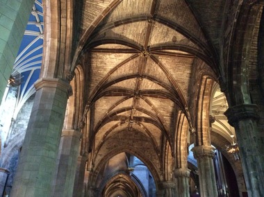 Ballarat Heritage Services
Digital Photograph, Dorothy Wickham, Interior, St Giles Cathedral, Edinburgh, Scotland, 10/2016
St Giles, also known as the High Kirk of Edinburgh is the principal place of worship for the Church of Scotland. It is very interesting for the mason's marks found on its many stone columns inside the church, and for its connections to the graveyard outside. According to wikipedia, "There is record evidence of a church here, very likely on the present site, in the year 854. In 1120 King Alexander I, rebuilt the church in the Norman style. Of this building characteristic features survived until 1798. During the fourteenth century, Edinburgh was captured and plundered by the English under Edward II. and Edward III., and twice St Giles was laid waste. After restoration, the church was more thoroughly ruined at the Burnt Candlemas in 1387, when Richard II. sacked the city. The western part of the fabric was soon in use again ; but the restoration of the choir and transepts, which were much enlarged, lasted on into the sixteenth century. In 1467 the city endowed St Giles as a collegiate church. It now became usual to speak of the nave, where the stonework was ancient, as the Old Kirk, while the eastern part of the building was called the New Kirk. When the movement for reform drew large crowds to St Giles, separate services began to be regularly held in the Old and New Kirks. Soon this was not enough, and the great church was partitioned off into smaller sections. In 1571 St Giles was seized by Kirkcaldie of Grange, and held by him as a stronghold for Queen Mary. This resulted in serious damage to the structure.Two colour photographs of the interior if St Giles Cathedral, Edinburgh, Scotlandst giles cathedral, architecture, mason's marks, stonemasons, church of scotland -
 Ballarat Heritage Services
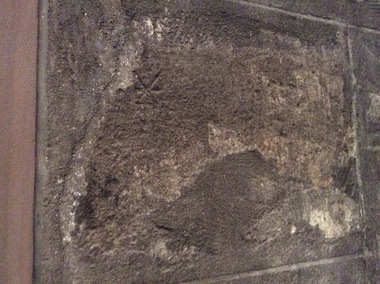
Digital Photograph, Stonemason's marks, St Giles Cathedral, Edinburgh, Scotland, 10/2016
St Giles, also known as the High Kirk of Edinburgh is the principal place of worship for the Church of Scotland. It is very interesting for the mason's marks found on its many stone columns inside the church, and for its connections to the graveyard outside. According to wikipedia, "There is record evidence of a church here, very likely on the present site, in the year 854. In 1120 King Alexander I, rebuilt the church in the Norman style. Of this building characteristic features survived until 1798. During the fourteenth century, Edinburgh was captured and plundered by the English under Edward II. and Edward III., and twice St Giles was laid waste. After restoration, the church was more thoroughly ruined at the Burnt Candlemas in 1387, when Richard II. sacked the city. The western part of the fabric was soon in use again ; but the restoration of the choir and transepts, which were much enlarged, lasted on into the sixteenth century. In 1467 the city endowed St Giles as a collegiate church. It now became usual to speak of the nave, where the stonework was ancient, as the Old Kirk, while the eastern part of the building was called the New Kirk. When the movement for reform drew large crowds to St Giles, separate services began to be regularly held in the Old and New Kirks. Soon this was not enough, and the great church was partitioned off into smaller sections. In 1571 St Giles was seized by Kirkcaldie of Grange, and held by him as a stronghold for Queen Mary. This resulted in serious damage to the structure.Colour photographs of tonemason's marks, St Giles Cathedral, Edinburgh, Scotlandmason's marks, st giles cathedral -
 Ballarat Heritage Services
Photograph - Digital Photograph, Stonemason's marks, St Giles Cathedral, Edinburgh, Scotland, 10/2016
St Giles, also known as the High Kirk of Edinburgh is the principal place of worship for the Church of Scotland. It is very interesting for the mason's marks found on its many stone columns inside the church, and for its connections to the graveyard outside. According to wikipedia, "There is record evidence of a church here, very likely on the present site, in the year 854. In 1120 King Alexander I, rebuilt the church in the Norman style. Of this building characteristic features survived until 1798. During the fourteenth century, Edinburgh was captured and plundered by the English under Edward II. and Edward III., and twice St Giles was laid waste. After restoration, the church was more thoroughly ruined at the Burnt Candlemas in 1387, when Richard II. sacked the city. The western part of the fabric was soon in use again ; but the restoration of the choir and transepts, which were much enlarged, lasted on into the sixteenth century. In 1467 the city endowed St Giles as a collegiate church. It now became usual to speak of the nave, where the stonework was ancient, as the Old Kirk, while the eastern part of the building was called the New Kirk. When the movement for reform drew large crowds to St Giles, separate services began to be regularly held in the Old and New Kirks. Soon this was not enough, and the great church was partitioned off into smaller sections. In 1571 St Giles was seized by Kirkcaldie of Grange, and held by him as a stronghold for Queen Mary. This resulted in serious damage to the structure.Three photographs of stonemason's marks, St Giles Cathedral, Edinburgh, Scotlandmason's marks, st giles cathedral -
 Ballarat Heritage Services
Photograph - Numismatics, Daylesford Borough Queen Victoria Jubilee Medallion, 1887, 1887
Queen Victoria's jubilee took place in 1887.Bronze coin featuring the Daylesford Town Hall on one side, and a profile of Queen Victoria on the other. daylesford borough queen victoria jubilee medallion, daylesford, queen victoria, numismatics, medallion, anniversary, jubilee -
 Ballarat Heritage Services
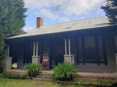
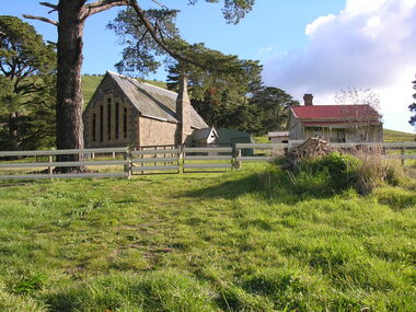
Photograph - Photograph - Colour, Clare Gervasoni, Former School at Weatherboard, Victoria, c2010
Weatherboard is a small town in Western Victoria.Anecdotally the name is thought to have originated because it was the first place in the region to have a home built using weatherboard rather than corrugated iron, stone or bricks. It is in the boundaries of the City of Ballarat. The School, Number 656, was opened on 01 August 1862 and closed on 04 February 1948. it was also known as Weatherboard Hill Common School and Weatherboard Hill State School.The bluestone school building had a slate roofand its first head teacher was James Richmond..In 1915 Health Officer, Dr Willis, strongly condemned the old bluestone building as being damp and unsanitary. in 1948 enrolments dropped to 6 and the school closed. The Weatherboard State School World War One Honour Board is located at Burrumbeet Hall. An early bluestone school known as the Weatherboard School.weatherboard school, former weatherboard school, education, weatherboard hill common school, weatherboard hill state school -
 Ballarat Heritage Services
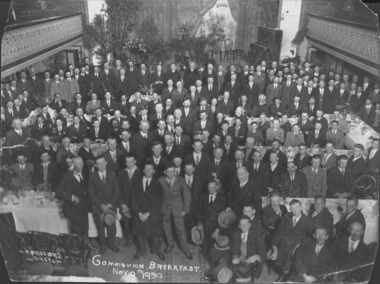
Photograph - Photograph - Black and White, St Peter's Daylesford Communion Breakfast, 1930, 09/11/1930
"ST. PETER'S DAYLESFORD. General Communion and Breakfast. On Sunday November 9, a general Communion of the men; of the parish will be held in St Peter's Church, Daylesford. A communion breakfast will subsequently take place." Melbourne Advocate, 30 October 1930. "General Communion and Breakfast, Daylesford War Memorial Protest by Rev. Dr. Collins Rights of Catholics Ignored THE splendid Catholicity of the Daylesford parish was demonstrated on Sunday morning last when a general Communion of the men of the parish took place at the 8 o'clock Mass at St. Peter's Church. This proud and edifying demonstration of faith concluded a very successful mission in the parish, conducted by the Rev. Fr. O'Flynn, C.SS.R., and Rev. Fr. Frean, C.SS.R., Daylesford parish is fairly scattered, and from every corner of it came men to take their part in the general Communion. The missioners and the Rev. W. M. Collins. D.D., P.P.. have reason to be deeply gratified at the result of the mission. His Grace the Archbishop of Melbourne (Most Rev. Dr. Mannix) was the celebrant of the Mass. He was assisted in administering the Sacrament by Rev. Dr. Collins. At the close of the Mass the hymn, "Faith of Our Fathers." was sung. The breakfast was served in the Daylesford Town Hall, the men marching there from the church. More than 250 partook of breakfast. In the balcony were lady parishioners who wished to listen to the speeches. His Grace the Archbishop was at the head table, and with him were Rev. W. M. Collins, P.P.; Crs. Bolton and Gleeson (Shire of Glenlyon), and Courtney (Shire of Davlesford); Messrs. Cleary and Egan (Blampied). Mr. J. T. Murphy. Mr. Considine, and Mr. O'Donnell (BuIIarto). Several selections were played by the Holy Cross Convent orchestra, Daylesford, and the catering was admirably carried out by Mrs. Mann. It was a well-organised and successful function, and the general arrangements reflected the highest credit on the Rev. Dr. Collins and those associated with him. Much favourable comment was made upon the great success achieved. A WAR MEMORIAL SERVICE. Strong Protest by Rev. Dr. Collins. The Rev. Dr. Collins said it was no exaggeration for him to say that he was a proud pastor that day. He had reason to be proud of the magnificent demonstration of faith made by the Catholic men of the parish at St. Peter's Church. It was promoted by a supernatural motive, and the men were sure to get their reward. He knew that many men had attended at great sacrifice, and that numbers had to grope about in the early hours to get everything in readiness at their farms and dairies. He was deeply thankful for the fine response made by the men to his invitation, and no greater encouragement could be given to him in his work in the parish. They had made a creditable demonstration before the people of Daylesford, whose good opinion they valued and wanted to retain. Catholics were part of the community, and the community's troubles were their troubles. Generally they had a few of their own troubles, but they were not wanting in helping the community to bear its troubles. Just now they were passing through a difficult time. The surrounding shires seemed to be better off than Daylesford, but the municipal fathers at Daylesford had spent a lot of money wisely in attracting tourists to the beautiful district. The money spent, he was certain, would come back a hundredfold. They appreciated the good work done by the municipal authorities, and were prepared to do their part in shoulder-ing their civic obligations. A Frankly Protestant Memorial Service. He could not let the occasion pass without calling the attention of the Daylesford people to an injustice that was being done the Catholic body, unwittingly he believed. Hie referred to the ceremony for the unveiling of the Soldiers' Memorial. It had been decided to adopt a frankly Protestant service. Catholics could not take part in a non-Catholic service, and that was not due in any way to any recent whim or caprice. Catholics had made common sacrifices, and the war memorial should stand for the Catholic boys who had fallen as well as non-Catholic soldiers. Catholics had contributed towards the cost of the memorial, and yet a programme had been adopted on the occasion of the public unveiling that excluded Catholics from taking part. They had a right to be at the ceremony, but it was asking them too much to shed their principles in order to be present. Their forefathers did not shed their principles when there was much more at stake, and they did not intend to shed theirs. They took that stand for Faith, and were still loyal citizens of Australia. The great majority, he was certain, did not realise the difficulties of Catholics, and that the stand taken was a matter of principle. There was always a minority, however, who were ever ready to score a victory over Rome at any price. Thanks to Non-Catholics. Having made his protest, he would not be honest if he did not express his gratitude to many non-Catholics in Daylesford for their help. In the Boxing Day carnival, which was their principal effort on behalf of the schools, non-Catholics gave splendid support, which he very much appreciated. The success of the carnival was dependent to a large extent on the generous help of Protestants. He trusted that the Catholic men generally would take note of what he said, and turn over a new leaf, as so many new leaves had been turned over since the mission. Missioners and Nuns Thanked. The work of the Redemptorist Fathers had been fruitful of results in the parish, and what they had done had paved the way for the magnificent men's demonstration. He wished heartily to thank the Fathers, and his thanks were also due to the Holy Cross Convent. If the Faith were strong in Daylesford, it was largely due to the Catholic schools in the district. They should never forget the Presentation nuns, and should be prepared to help them in every possible way. He was very thankful to the Rev. Mother for her kindness in entertaining many at the convent, and also for providing the orchestra at the Communion breakfast. A Splendid Success. He was greatly delighted at the presence of his Grace the Archbishop. When he started to talk about the breakfast, many told him it would not be a success. First of all, it was intended to hold the breakfast in the schoolroom, but the response was so good that it was considered they should get the Rex Theatre. Finally, they were compelled to take the Town Hall in order to accommodate the large number who purchased tickets. The presence of his Grace gave additional lustre to the successful demonstration. He was proud of the men of the parish, and hoped God would bless them and their families. (Applause.) The first toast honoured was that of "The Pope and the King." WELCOME TO HIS GRACE Proposing the toast of "His Grace the Archbishop," Cr. J. Bolton said he wished to congratulate the Rev. Dr. Collins on the wonderful success of the two functions. All parts of the parish were represented at the general Communion in St. Peter's Church, and it was an inspiring spectacle. It showed that the Faith was deep and strong in Daylesford. A great privilege had been given to them, and they owed grateful thanks to the Rev. Dr. Collins. He wished to welcome his Grace the Archbishop, and he trusted that he would enjoy his visit to the district. The country was passing through a difficult time at present, and it required plenty of clear thinking and acting to put things right again. He hoped his Grace would touch on the situation, and give them the benefit of his thoughtful and wellreasoned views. Whatever his Grace said would be worth listening to. (Applause.) THE ARCHBISHOP CONGRATULATES PASTOR AND PEOPLE. DAYLESFORD A MODEL PARISH. His Grace the Archbishop said he need not assure them that he came to Daylesford with great pleasure. His visits to Daylesford were always pleasant, but the present visit was additionally pleasant and memorable because he had the opportunity of assisting at one of the most inspiring functions that it had ever been his good fortune to attend. He was really touched to the heart when he stood on the altar and saw the beautiful St. Peter's Church—there were few churches to compare with it in the country—filled with the men of Daylesford and of the surrounding districts. Practically all the Catholic men in the parish were present at the general Communion, and it gave him very deep satisfaction and genuine pleasure to be amongst them. As the Rev. Dr. Collins and Cr. Bolton had said, it was a proof of the depth and soundness of the Faith of the Catholic people of the parish. He wished to congratulate the Rev. Dr. Collins upon the magnificent success that had attended his efforts since he came to Daylesford. He thought the Rev. Dr. Collins had been a very happy man since he took up work in the parish. He came to Daylesford more or less broken in health, and his best friends were doubtful whether his health would stand the strain of parochial duty. However, he had never looked back. He doubted if Dr. Collins would care to leave Daylesford, unless he were appointed Prefect of Propaganda, Rome, or some very high distinction was conferred on him. At all events, things had gone on well with Dr. Collins since he came to Daylesford, and he could see some of the reason for it in looking at the fine gathering before him. The Rev. Dr. Collins was a very zealous and spiritual man, and his lot had been cast amongst people who had responded to his labours. ... (Melbourne Advocate, 13 November 1930) Black and white photograph taken in Daylesford Town Hall depicting numerous men standing, and sitting at tables during the St Peter's Catholic Church Communion Breakfast. Arch Bishop Daniel Mannix stands centre back.st peter's catholic church, daylesford, communion breakfast, daylesford town hall, daniel mannix, george gervasoni, gus gervasoni -
 Ballarat Heritage Services
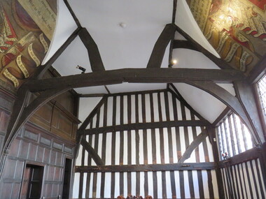
Photograph - Digital Photograph, Leicester Guildhall
The Leicester Guildhall is adjacent to Leicester Cathedral where King Richard III has been reinterred. The interpretative centre nearby is situated upon the car park where his remains were uncovered. The Great Hall was built in 1390 and dates back to medieval days. It was a meeting place for the Guild of Corpus Christi, a select group of influential businessmen and gentry founded in 1343. The Guild had their own altar in the Church of St Martin (now Leicester Cathedral) and used the Great Hall for banquets. By 1563 the building was Leicester's Town Hall. guild hall -
 Ballarat Heritage Services
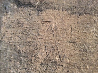
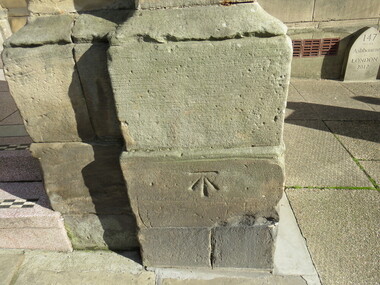
Digital Photograph, Stonemason mark, Ashbourne Town Hall, UK
Ashbourne is one of Derbyshire's fines and most vibrant market towns. It combines a wealth of historic buildings and shops. The Market Place is cobbles with hidden alleys and yards that lead to the carparks behind the main street. The wide and elegant Church Street is considered to be the finest street of Georgian buildings in Derbyshire. Tissington Hall and Village are in the nearby vicinity. Built by Francis Fitzherbert in 1609 Tissington Hall has been lived in by the Fitzherbert family ever since. The estate village has a number of micro businesses and a beautiful duck pond. Reference: Information from the Ashbourne Tourist pamphletmason marks ashbourne derbyshire market town francis fitzherbert tissington -
 Ballarat Heritage Services
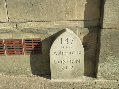
Digital Photograph, Milestone, Ashbourne, UK
Ashbourne is one of Derbyshire's fines and most vibrant market towns. It combines a wealth of historic buildings and shops. The Market Place is cobbles with hidden alleys and yards that lead to the carparks behind the main street. The wide and elegant Church Street is considered to be the finest street of Georgian buildings in Derbyshire. Tissington Hall and Village are in the nearby vicinity. Built by Francis Fitzherbert in 1609 Tissington Hall has been lived in by the Fitzherbert family ever since. The estate village has a number of micro businesses and a beautiful duck pond. Reference: Information from the Ashbourne Tourist pamphlet