Showing 40 items matching "plain shaft"
-
 Ballarat Heritage Services
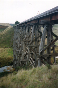
Photograph - Photograph - Colour, Clare Gervasoni, Nimon's Bridge, 1999, 04/10/1999
... plains intersected by deep wide valleys occasionally subject to severe flooding. Nimons Bridge is aesthetically significant for its visually impressive viaduct form, crossing a deep and steep-sided valley that is part of a rich cultural landscape. Within close proximity of the bridge are mullock dumps, tailings, shaft...plains intersected by deep wide valleys occasionally subject to severe flooding. Nimons Bridge is aesthetically significant for its visually impressive viaduct form, crossing a deep and steep-sided valley that is part of a rich cultural landscape. Within close proximity of the bridge are mullock dumps, tailings, shaft ...Nimons Bridge was built in 1890, as part of the then Ballarat-Linton railway. The bridge is 17 spans with tall timber piers of four driven piles each, with triple sets of diagonal cross-bracing and walers and a single row of longitudinal horizontal bracing between piers. The spans are of a uniform twenty feet (6.1 metres), originally supported by four 21-inch x 9-inch (535 mm x 230 mm) Kauri timber beams per span, following the standard V.R. design of the period. When the superstructure was rebuilt after the 1953 fire, the timber beams were replaced with two 24-inch (610mm) deep rolled-steel-joists on each span. These are marked 'Lancashire Steel Co., Scotland' and are believed to have been second-hand. The deck of transverse-timber planks is 103.6 metres in length. Overall the bridge has an impressive appearance with its exceptionally tall triple-cross-braced piers creating a 'three-tiered' effect, with the deck 19.2 metres above the Woady Yaloak River. The Ballarat-Skipton line closed in 1985. Nimons Bridge has been recently restored, as part of the Ballarat-Skipton Rail Trail. How is it significant? Nimons Bridge is significant for technical, historic and aesthetic reasons at a State level. Why is it significant? Nimons Bridge is technically significant as Victoria's fourth-tallest timber trestle bridge when built, and as the third-tallest surviving example. It is also the second-largest composite bridge combining traditional timber piers with RSJ spans and a timber deck and falls within a select group of fewer than ten timber railway bridges with horizontal longitudinal bracing between the piers and three sets of double cross-bracing on its tallest piers, creating a visually striking 'three tiered' effect that enhances its viaduct form. Nimons Bridge is historically significant as having served initially the mining community at Linton, then the Western District agricultural area and in later years a kaolin quarry at Pittong. Nimons Bridge is historically significant as a representative of the 'light' branch line methodology that stimulated the explosion of railway construction in Victoria during the 1880s, and provides an interesting contrast with the more solid and vastly more expensive railway viaducts built in similar terrain on Victorian main lines, at Moorabool and Taradale, in the late 1850s. Approached by a deep cutting and high embankment at either end, the bridge represents a very cost-effective late 19th century engineering solution to the characteristic physiography of western Victoria with flat basalt plains intersected by deep wide valleys occasionally subject to severe flooding. Nimons Bridge is aesthetically significant for its visually impressive viaduct form, crossing a deep and steep-sided valley that is part of a rich cultural landscape. Within close proximity of the bridge are mullock dumps, tailings, shaft sites and other relics of the deep-lead alluvial mining era. The bridge is the most visually spectacular timber-trestle rail bridge in Western Victoria and is among the most spectacular timber-trestle rail bridges surviving anywhere in Victoria. It is part of the Ballarat-Skipton Rail Trail. Classified by the National Trust :02/10/2000 (http://vhd.heritagecouncil.vic.gov.au/places/67986)Colour photograph of a log bridge known as Nimon's Bridge.ballarat-linton, nimons bridge, nimon's bridge, log bridge, viaduct, timber-trestle rail bridge -
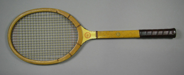
 Tennis Australia
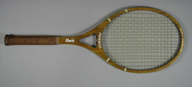
Racquet, Circa 1981
... plain leather handle grip. Model name features across base of head. Davis logo features along shaft TAD trademark features on rubber butt cap. ...plain leather handle grip. Model name features across base of head. Davis logo features along shaft TAD trademark features on rubber butt cap. ...A Davis Imperial, walnut-fibreglass composite tennis racquet, with an open throat and large head. Racquet features ribbon whipping around shoulders, and plain leather handle grip. Model name features across base of head. Davis logo features along shaft TAD trademark features on rubber butt cap. Materials: Wood, Nylon, Ink, Glue, Lacquer, Metal, Ribbon, Leather, Adhesive tape, Rubber, Fibreglass, Painttennis -
 Tennis Australia
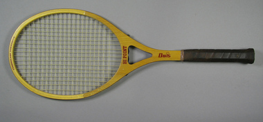
Racquet, Circa 1981
... plain leather handle grip. Model name features across base of head. Davis logo features along shaft. ...plain leather handle grip. Model name features across base of head. Davis logo features along shaft. ...A Davis Hi Point, fibreglass composite tennis racquet, with an open throat and large head. Racquet features plain leather handle grip. Model name features across base of head. Davis logo features along shaft. TAD trademark features on rubber butt cap. Materials: Wood, Nylon, Ink, Glue, Lacquer, Metal, Leather, Adhesive tape, Rubber, Fibreglass, Painttennis -
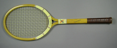
 Tennis Australia
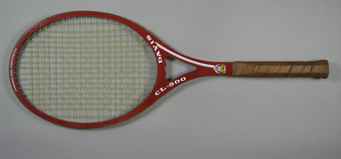
Racquet, Circa 1977
... plain leather handle grip. Davis logo features across base of head. Model name features along split shaft. ...plain leather handle grip. Davis logo features across base of head. Model name features along split shaft. ...A Davis CL-500, fibreglass composite tennis racquet, with an open throat and large head. Racquet features plain leather handle grip. Davis logo features across base of head. Model name features along split shaft. TAD "Kings of the Court" trademark features on lower shaft on reverse. Davis coat-of-arms "Duce virtute comite fortuna" trademark features on lower shaft on obverse. TAD trademark features on rubber butt cap. Materials: Wood, Nylon, Ink, Glue, Lacquer, Metal, Leather, Adhesive tape, Rubber, Fibreglass, Painttennis -
 Tennis Australia
Racquet, Circa 1947
... A Spalding 'Johnny Lamb' tennis racquet, with whipping around shoulders and shaft, and a plain leather handle grip. Model name features across throat on obverse; logo of the Valley Hunt Club features on throat on reverse. ...Tennis Australia Melbourne Park Olympic Boulevard Melbourne Park Melbourne melbourne Tennis A Spalding 'Johnny Lamb' tennis racquet, with whipping around shoulders and shaft, and a plain leather handle grip. Model name features across throat on obverse; logo of the Valley Hunt Club features on throat on reverse. ...A Spalding 'Johnny Lamb' tennis racquet, with whipping around shoulders and shaft, and a plain leather handle grip. Model name features across throat on obverse; logo of the Valley Hunt Club features on throat on reverse. Latin American version of Spalding ball trademark features on shaft (i.e. MARCA REGISTRADA/SPALDING). Materials: Wood, Glue, Metal, Lacquer, Nylon, Leather, Ink, Paint, String, Ribbontennis -
 Tennis Australia
Racquet, Circa 1945
... plain leather handle grip. Manufacturer's name features across base of head, and on cloth butt cover. Model name features across collar. Spalding wreathed ball trademark (i.e. MARCA REGISTRADA/SPALDING), features on shaft...plain leather handle grip. Manufacturer's name features across base of head, and on cloth butt cover. Model name features across collar. Spalding wreathed ball trademark (i.e. MARCA REGISTRADA/SPALDING), features on shaft ...A Spalding 'Olympic' tennis racquet, with an open throat, plastic whipping around shoulders and plastic molded collar, and a plain leather handle grip. Manufacturer's name features across base of head, and on cloth butt cover. Model name features across collar. Spalding wreathed ball trademark (i.e. MARCA REGISTRADA/SPALDING), features on shaft, on obverse. Materials: Wood, Glue, Metal, Lacquer, Nylon, Leather, Ink, Enamel, String, Plastic, Cloth, Adhesive tapetennis -
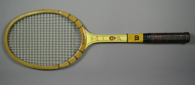 Tennis Australia
Racquet, Circa 1963
... Throat features plain gold trophy cup device. Shaft features decal head and neck illustration of Kramer. ...Throat features plain gold trophy cup device. Shaft features decal head and neck illustration of Kramer. ...A Wilson, Jack Kramer Cup tennis racquet. Base of head features Wilson logo. Throat features plain gold trophy cup device. Shaft features decal head and neck illustration of Kramer. Shaft and butt cap feature 'W' trademark. Leather handle grip features triangle-pattered perforations. Materials: Wood, Nylon, Leather, Ink, Glue, Lacquer, Metal, Plastic, Paint, Ribbon, Adhesive tape, Stringtennis -
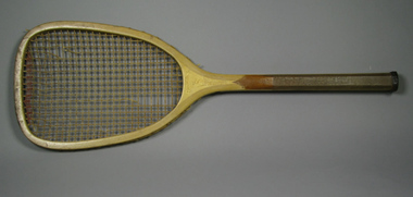 Tennis Australia
Racquet, Circa 1885
... A John Wanamaker Belmont flat top tennis racquet, with solid concave throat, and plain, slender handle. Hand etched inscription across throat and shaft on obverse: W.J. ...Tennis Australia Melbourne Park Olympic Boulevard Melbourne Park Melbourne melbourne Tennis A John Wanamaker Belmont flat top tennis racquet, with solid concave throat, and plain, slender handle. Hand etched inscription across throat and shaft on obverse: W.J. ...A John Wanamaker Belmont flat top tennis racquet, with solid concave throat, and plain, slender handle. Hand etched inscription across throat and shaft on obverse: W.J. POWNALL, NEWTON/P.A./1896 ASBURY...DEL VILLA. Materials: Wood, Lacquer, Glue, Metal, Leather, Gut, Inktennis -
 Bendigo Historical Society Inc.
Map - RAYWOOD GOLD FIELD MAP, 1902
... Mentions the Parish of Yallook, Parish of Neilborough, Yarraberb, Mushroom Flat, Murray Valley Plain, Eaglehawk and Kerang Railway, Green Hill, Doughboy, Redmond's Gully, Pickpocket Lead, Raywood Lead, Inglewood Lead, Shaw's Road, Nuggety Shaft, Barkly Shaft, Maori Bend...Mentions the Parish of Yallook, Parish of Neilborough, Yarraberb, Mushroom Flat, Murray Valley Plain, Eaglehawk and Kerang Railway, Green Hill, Doughboy, Redmond's Gully, Pickpocket Lead, Raywood Lead, Inglewood Lead, Shaw's Road, Nuggety Shaft, Barkly Shaft, Maori Bend Map RAYWOOD GOLD FIELD MAP ...Map. Raywood Gold Field Map. Linen backed map of Raywood and Neilborough Township and surrounds showing the location of varying underground workings. Surveyed by H S Whitelaw 1/6/02. It shows underground workings from The Perseverance Party and moreshed and Party and underground workings on the Old Pioneer Reef. Mentions the Parish of Yallook, Parish of Neilborough, Yarraberb, Mushroom Flat, Murray Valley Plain, Eaglehawk and Kerang Railway, Green Hill, Doughboy, Redmond's Gully, Pickpocket Lead, Raywood Lead, Inglewood Lead, Shaw's Road, Nuggety Shaft, Barkly Shaft, Maori Bendmap, gold field map, raywood gold field map, neilborough, h s whitelaw, geological survey of victoria bulletin no 12 plate 11 -
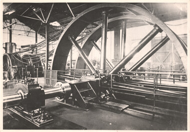 Melbourne Tram Museum
Photograph - Interior of a cable tram Engine House, c1900
... shafts. Location not known, though it could be Brunswick given the location of a doorway. Also known as winding houses or power houses. Yields information about the interior of an engine house. Tramways Engine Houses cable trams winding houses Black and white print with plain ...Photograph of the interior of a Melbourne cable tram engine house showing the rope drives and the drive shafts. Location not known, though it could be Brunswick given the location of a doorway. Also known as winding houses or power houses.Yields information about the interior of an engine house.Black and white print with plain backtramways, engine houses, cable trams, winding houses