Showing 25572 items matching "plenty-township-estate"
-
 Ringwood and District Historical Society
Map, Two Partially Trimmed Copies of Ringwood Township Estate subdivision advertisement - 1919
Clippings on cardboard backing. Handwritten sales notations on numbered allotments in Ellison Street, Haig Street and Wantirna Road, Ringwood.One copy includes three oval rubber stamp impressions - F. Parker, Estate Agent, Ringwood. -
 Greensborough Historical Society
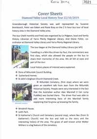
Booklet and article, Diamond Valley Local History Tour 2019, by Yarra Plenty Regional Library, 22/10/2019
Cover article written by Rosie Bray. In addition to YPRL booklets which have a brief history of each site visited, there are leaflets on Anglican parish of Diamond Creek; Nillumbik Cemetery; Ellis Cottage; Greensborough Cemetery and Sutherland Homes for ChildrenBooklet (2 copies) containing a brief history of sites visited on the Library's Diamond Valley Tour 2019, with 21 p. of supplementary information by various writers and 6 photographs taken on the tour.diamond valley, yarra plenty regional library, sutherland homes, st katherines church st helena, andrew yandell reserve, greensborough rsl, greensborough war memorial park, greensborough cemetery -
 Greensborough Historical Society
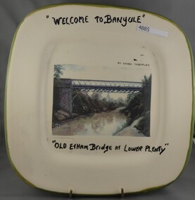
Plate, Serge Daeffler, Old Eltham Bridge at Lower Plenty, 1980s
Ceramic plate, decorated by Serge Daeffler. Hand painted text with transfer illustration of the Old Eltham Bridge at Lower Plenty which was opened on 8/3/1867.Ceramic plate, off-white with green edges, colour transfer photograph, glazed"Welcome to Banyule", "Old Etham (sic) Bridge at Lower Plenty", by Serge Daeffler. Card of Banyule's Heidelberg School Heritage Artist, Robert S, Phillips attached to rear, with price label from Savers.plates, lower plenty -
 Rutherglen Historical Society
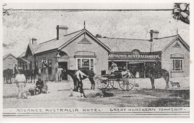
Image, Advance Australia Hotel - Great Northern Township, c1893
Black and white photograph of a hotel, with a number of people, dogs and horses, and two horse carts shown in the foreground.Written on back of photo "Opened 19/4/1893"advance australia hotel, hotels -
 City of Kingston
Pamphlet - Colour, R. Malcolm Estate Agents et al, Last Chance Land Sale Heritage Estate Cheltenham, c.1994
Sales plan for land in the suburb of Cheltenham, bounded by Chesterville Road and Bernard Street, and incorporating Clendon Court, Tintern Grove and Tintern MewsThis land sale pamphlet illustrates one of the last subdivisions of the century in Cheltenham, incorporating house and land packages. It shows that land sales and subdivision for the area had slowed considerably by the end of the 1900s and that the infrastructure was significantly developed. Colour pamphlet advertising last chance land sale of Heritage Estate Cheltenham. Incorporates a map of the estate bordered by Chesterville Road and Bernard Street, and including Clenton Court, Tintern Grove and Tintern Mews.cheltenham, land sales, estate -
 Phillip Island and District Historical Society Inc.
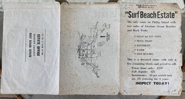
Booklet, Surf Beach Estate, About 1950
W. Davie was a local real estate agentHistoricalBooklet advertising the Surf Beach Estate . Large sheet printed on both sides. One side has map of the estate. other has information about estate, agent and location on Island" Surf Beach Estate" '"The only estate on Phillip island with two miles of Glorious Ocean Beaches and Rock Pools." Prices from only 250 pound.surf beach, real estate, w davie, town planning -
 Eltham District Historical Society Inc
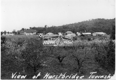
Photograph, View of Hurstbridge township
View across an orchard of flowering fruit trees towards the small township of Hurstbridge. Around 1920s.This photo forms part of a collection of photographs gathered by the Shire of Eltham for their centenary project book, "Pioneers and Painters: 100 years of the Shire of Eltham" by Alan Marshall (1971). The collection of over 500 images is held in partnership between Eltham District Historical Society and Yarra Plenty Regional Library (Eltham Library) and is now formally known as 'The Shire of Eltham Pioneers Photograph Collection.' It is significant in being the first community sourced collection representing the places and people of the Shire's first one hundred years.Digital imageView of Hurstbridge townshipsepp, shire of eltham pioneers photograph collection, hurstbridge, orchards -
 Greensborough Historical Society
Photograph - Digital Image, Plenty Bridge Hotel Lower Plenty c1920, 1920s
Plenty Bridge Hotel Lower Plenty, 1920s. This photograph shows the Plenty Bridge Hotel circa 1920. Digital copy of black and white photographlower plenty, plenty bridge hotel, lower plenty hotel -
 Eltham District Historical Society Inc
Photograph, Yallambie Estate, Lower Plenty
Black and white photograph of Yallambie Estate prior to residential subdivision, 'Yallambie' in backgroundyallambie, lower plenty -
 City of Kingston
Pamphlet - Colour, S. M. Reynolds, Estate Agent, Moorabbin Shire Hall Estate Second Section, c. 1930
Sales plan for land in the suburb of Moorabbin, bounded by South Road and Highbury Street, including Prince Street, Charming Street, Thomas Avenue and Keith Road.The developing urban area of Moorabbin within the City of Kingston. This land sale pamphlet illustrates the subdivision of land within the municipality and the changing demographic of the district as new houses are constructed close to infrastructure.Colour pamphlet advertising for private sale the Moorabbin Shire Hall Estate, Moorabbin. Incorporates a map of the estate bordered by South Road and Highbury Street, including Prince Street, Charming Street, Keith Road and Thomas Avenue.Handwritten in grey pencil on subdivision map below subdivision 63: £4 Handwritten in grey pencil on subdivision map below subdivision 66: 4 Handwritten in grey pencil on subdivision map below subdivision 80: 3. Handwritten in grey pencil on subdivision map below subdivision 81: 4 Handwritten in grey pencil on subdivision map below subdivision 83: 2 Handwritten in grey pencil on subdivision map below subdivision 96: £3 Handwritten in grey pencil on subdivision map below subdivision 97: 3 Handwritten in grey pencil on subdivision map to the left of subdivision 102: 3 Handwritten in grey pencil on subdivision map on the corner of Thomas Avenue and Highbury Street: vertical line next to a square with a cross in it.land sales, estate, moorabbin -
 Greensborough Historical Society
Photograph - Digital Image, Lower Plenty and Yallambie Roads Lower Plenty 1974, 1974_
Lower Plenty 1974. This photograph shows the corner of Lower Plenty Road and Yallambie Road Lower Plenty in 1974. This road is now controlled by traffic lights and Lower Plenty Road is duplicated.Digital copy of black and white photographlower plenty, yallambie road lower plenty, main road lower plenty, lower plenty road lower plenty -
 City of Kingston
Pamphlet - Colour, W. H. Wood Estate Agent, Subdivisional Land Auction Barker's Estate Cheltenham, 1919
Sales plan for land in the suburb of Cheltenham, along Barker StreetThe developing urban area of Cheltenham within the City of Kingston. This land sale pamphlet illustrates the subdivision of land within the municipality and the changing demographic of the district as new houses are constructed.Colour pamphlet advertising subdivisional land auction of Barker's estate, on Barker Street Cheltenham.Handwritten in grey pencil on the subdivision map: a series of numbers on each block possibly indicating the sale price. Handwritten in grey pencil on the subdivision map: Roy- joined to subdivision 6 Handwritten in grey pencil on the subdivision map: x on the border between subdivision 17 and 16, and again on the border between subdivision 12 and 11.cheltenham, land sales, estate -
 Ringwood and District Historical Society
Flyer, Land Sale Advertisement - East Ringwood Township Estates, East Ringwood, Victoria - circa 1920
The date of the flyer as circa 1920 can be estimated from the references to the (decision on) "electrification of the Croydon Railway Line" which eventually occurred in 1923, letting of tenders for the state school building which opened in 1924, and the "proposed new railway station" (East Ringwood) which opened in 1925, Advertisement for three retail and residential allotment land sales in East Ringwood Township including maps showing layout of subdivisions. Township Estate, State School Estate, and East Ringwood Station Estate.Subdivision plans include Mount Dandenong Road, Grey Street, Eastfield Road, King Street, Everard Road, Holland Road, Purser Avenue, and Charles Street. (Agents) Spencer Jackson, Subdivider & Homebuilder, 341 Collins Street, Melbourne, Phones: M2327 (3 lines), also at Dromana, Phone 65. -
 Greensborough Historical Society
Photograph - Digital Image, Plenty Bridge Hotel, Lower Plenty, 1870s
Lower Plenty Hotel. This photograph shows the original Plenty Bridge hotel with Lower Plenty bridge in the foreground. The hotel was built c1858 and the bluestone bridge in the 1860s to replace the earlier toll bridge built in 1858.The close proximity of the hotel to the bridge is an indication of the importance of these river crossings in the mid 19th centuryDigital copy of black and white photographlower plenty, plenty river, plenty bridge hotel, lower plenty bridge, lower plenty hotel -
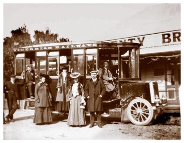 Greensborough Historical Society
Photograph - Digital Image, Plenty Bridge Hotel Lower Plenty c1910, 1910s
Plenty Bridge Hotel Lower Plenty, 1910s. This photograph shows a group of travellers with a Victorian Railways bus outside the Plenty Bridge Hotel circa 1910. A day trip to the countryside was a popular pastime for city dwellers.Digital copy of black and white photographlower plenty, plenty bridge hotel, lower plenty hotel, victorian railways -
![Advertising Leaflet, John McEwen and Co, Heidelberg Park Estate [Lower Plenty], 1913c](/media/collectors/4f729f5697f83e03086015b8/items/5dcfb52321ea671434e9ca4c/item-media/5dcfb56321ea671434ea0352/item-fit-380x285.jpg) Greensborough Historical Society
Greensborough Historical SocietyAdvertising Leaflet, John McEwen and Co, Heidelberg Park Estate [Lower Plenty], 1913c
Copy of auction leaflet for the sale of land fronting the Plenty River. Known as Heidelberg Park, this land is in what is now Lower Plenty. Sale circa 1913Digital copy of auction leaflet, 1 page.heidelberg park, lower plenty, land sales -
 Tatura Irrigation & Wartime Camps Museum
Photograph, Eildon Township, 1957
Taken by photographer for State Rivers and Water Supply Commission.Medium sized black and white photo. Aerial photograph - looking down on township in middle foreground - overflow dam to the right, middle distance - dam wall with reservoir beyond - mountain tops forming horizonOn frame below photo: "Eildon Township."victoria state rivers and water supply commission, eildon -
Greensborough Historical Society
Maps, Plenty River, 1837o
These maps show the land use along the Plenty River. Both Aboriginal and white settlements are shown.Set of maps showing the Plenty River. -
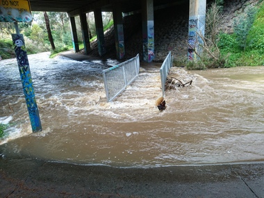 Greensborough Historical Society
Photograph - Photograph - Digital Image, Marilyn Smith, Plenty River high water 2020, 24/08/2020
Digital images of high water in the Plenty River at Greensborough 24/08/2020. Part of a collection of miscellaneous historical images with a connection to the local area.7 Digital colour photographs of the Plenty River. plenty river, floods -
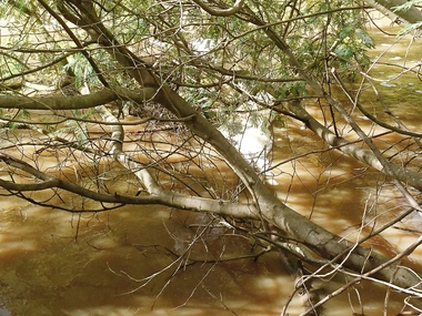 Greensborough Historical Society
Photograph - Photograph - Digital Image, Marilyn Smith, Plenty River high water 2020, 24/08/2020
Digital images high water in the Plenty River at Greensborough 24/08/2020. Part of a collection of miscellaneous historical images with a connection to the local area.7 Digital colour photographs of the Plenty River. plenty river, floods -
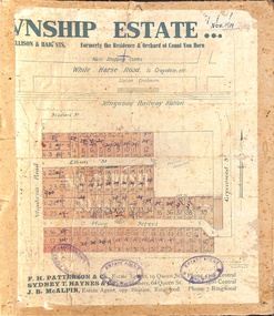
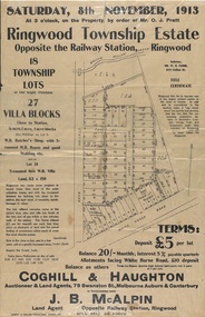 Ringwood and District Historical Society
Flyer, Auction Sale Advertisements - Ringwood Township Estate, Ringwood, Victoria - 1913
Advertisements for auction sale of retail and residential blocks opposite the Ringwood Railway Station on Saturday, 8th November, 1913, showing subdivision layout, terms of sale, and summary of local features and services. Auction at 3 o'clock on the property by order of Mr. O.J. Pratt - 18 township lots, 27 villa blocks, also weatherboard butcher's shop with 5-roomed weatherboard house and good stabling, and 5-roomed new weatherboard villa. Subdivision includes Station Road (later Warrandyte Road), Pratt Street, and Whitehorse Road. Agents - Coghill & Haughton, 79 Swanston Street, Melbourne, Auburn & Canterbury, in conjunction with J.B. McAlpin, Opposite Railway Station, Ringwood. Additional 2 partially trimmed copies allotment maps on cardboard backing with handwritten sales notations. -
Ringwood and District Historical Society
Pamphlet, Carter Real Estate, Carter & Son Pty Ltd Real Estate - Client newsletter 1995, Sep-95
Newsletter to clients including article related to the "Australia Remembers" celebrations.|The single page has ads for C.E. Carter and A.T. Miles plus The Mocha Cafe.3 A4 pages headed Client Newsletter - Carter & Son Pty Ltd Real Estate; Single photocopied page with ads and map +Additional Keywords: Carter, Richard / Miles, A.T. -
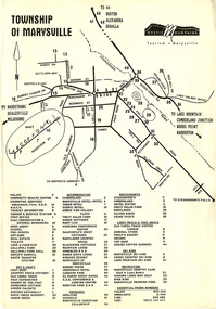 Marysville & District Historical Society
Flyer (Item) - Town map, Mystic Mountains Tourism, TOWNSHIP OF MARYSVILLE, Unknown
A map of the township of Marysville published by Mystic Mountains Tourism in Marysville. The map shows a legend of various services, accommodation sites, shops restaurants and recreation spots in the township.A map of the township of Marysville published by Mystic Mountains Tourism in Marysville.marysville, victoria, australia, mystic mountains tourism, map -
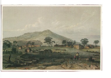 Buninyong & District Historical Society
Artwork, other - Colour reproduction of lithograph "Township of Buninyong" c1852, "Township of Buninyong" c1852
Early image of Buninyong c1852 showing evidence of land clearing, cultivation, residential and farm buildings and Mount Buninyong with tree coverBuninyong was one of the earliest settlements Victoria and became a very important place in the history of the goldrushColour reproduction of lithograph "Township of Buninyong" c1852 from the cover of "Three Times Blest"Henry Winkles Township of Buninyong c 1852 Lithograph, originally published in Montgomery Martin's "Australia" Reproduced "Three Times Blest"early settlement, henry winkles, mount buninyong, buninyong -
Hume City Civic Collection
Map, Sunbury Township 1857
This is a reprint of a 1857 map of the township of Sunbury in the County of Bourke produced by the Public Records Office by courtesy of the Surveyor General in 1978.This is a reprint of a 1857 map of the township of Sunbury.sunbury, shire of bulla, sunbury township, 1850s -
 Phillip Island and District Historical Society Inc.
Booklet, Cowes McRae Beach Estate, 1960s
This land was owned by the McRae family, whose wife was a Justice. Hence the street names of McRae and Justice. The weatherboard family home [ originally a guest house called Glen Isle] was at the end of the current Justice Road. The estate was created in the mid 1960s. The house was put on skids and dragged by two tractors and a bulldozer to 364 Church Street while the family home was built at 368 Church Street, Cowes.[ Source Sandra Rocotas, nee McCrae. Facebook Community Noticeboard 5/2/2023. Permission given to use information and photos ] Estate was sold by Rogan Real Estate.HistoricalColoured A4 brochure describing the McRae Beach Estate, including plan of streets and location on Island, photos and description of the Island. Sold by Rogan Real Estate.Cowes McRae Beach Estate - Right in the heart of things .Phillip Island - The Loveliest Isle on Earthhousing, justice family, mcrae family, cowes west, rogan real estate cowes phillip island, glen isla -
 Greensborough Historical Society
Article, Lucy Grace Ellem, Picturesque and panoramic: English landscape traditions and the Plenty Valley; by Lucy Grace Ellem, 1995
Conference paper comparing the natural Australian landscape with the influence of English landscape traditions.Photocopy of transcript of conference paper, 15 pages.plenty river, plenty valley, flora, landscapes -
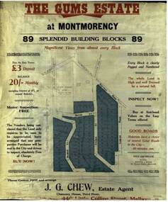 Greensborough Historical Society
Advertising Leaflet, The Gums Estate, 28/11/1925
Sale brochure for The Gums Estate, 89 building blocks bordered by Rattray and Looker Roads Montmorency. J. G. Chew, Estate AgentColoured photocopy of sale brochure the gums estate, rattray road montmorency, looker road montmorency, sylvan street montmorency, alban street montmorency -
 Greensborough Historical Society
Photograph - Photographs, Rosie Bray, Plenty Valley Quilters at work 2004, 2004
3 photographs from the Patchwork Gallery in Watsonia taken by Rosie Bray. Photos are captioned "Plenty Valley quilters at work".3 colour photographs, captions on back.Captions: photograph 1: "Plenty Valley Quilters at work"; photo 2: "Plenty Valley Quilters"; photo 3: "Plenty Valley quilt"layt family, the patchwork gallery, watsonia, quilting, plenty valley quilters -
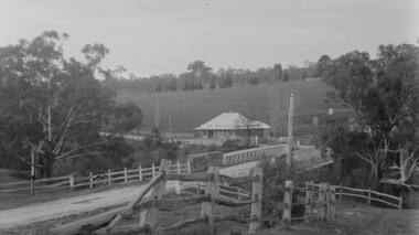
![Negative - Photograph, Coghill & Haughton, A Beautiful Home on the Plenty [Yallambie, Lower Plenty], c.1924](/media/collectors/4f729f7b97f83e03086018a5/items/62365fb2c8228c0f0d9ff3d8/item-media/6600e1625527135282394551/item-fit-380x285.jpg) Eltham District Historical Society Inc
Eltham District Historical Society IncNegative - Photograph, Coghill & Haughton, A Beautiful Home on the Plenty [Yallambie, Lower Plenty], c.1924
Negative copy and associated print of detail from original Sales Brochure: Plenty Township Estate and Bryn Teg Hill's Estate, Coghill & Haughton, Melbourne (c.1924)Roll of 35mm Black and White negative film, 3 strips, (1 of 14 frames) Print 10 x 15 cmFilm - Agfa Ortho 25bryn teg hill's estate, coghill & haughton, sales brochure, houses, lower plenty, plenty-river, yallambie