Showing 3055 items matching "public building"
-
 Linton and District Historical Society Inc
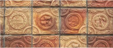
Photograph, Detail of Handmade Tiles on Public Toilet Block, Linton
... Public toilet building Linton.... Public toilet building Linton Hand made tiles Terracotta tiles ...The tiles were made by Linton Primary School pupils and members of the community as part of the Press Mould Tile Project 2001-2002. See Registration no. 2019-184 for more information.Colour photograph which shows handmade tiles used to clad the Linton public toilet block near the Shire offices in Sussex Street. The tiles depict stock animals, wildlife and historic themes, such as gold mining.public toilet building linton, hand made tiles, terracotta tiles, community art projects, press mould tile project 2001-2002 -
 Bendigo Historical Society Inc.
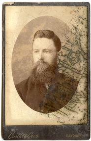
Photograph - ADULT MALE PORTRAIT, late 1800's ?
... Opposite Shamrock Hotel and New Public Buildings.... Public Buildings. sepia studio photograph of adult male, bearded ...sepia studio photograph of adult male, bearded and moustache , bareheaded, jacketed, hear and shoulders shown in oval on white surround. Glazed surface to print. Print mounted on rectangular black card.printed on front 'Bartlett Bros, Sandhurst. Printed on back 'Bartlett Bros, Photographers, Sandhurst, William Street Opposite Shamrock Hotel and New Public Buildings.person, individual, male, bartlett bros., sandhurst -
 Linton and District Historical Society Inc
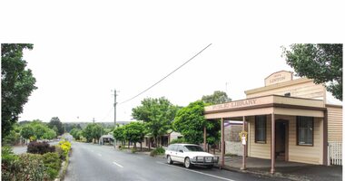
Photograph, Public Library, Linton
... Public Library building.... of the former Linton Public Library building. Public Library, Linton ...Colour photograph showing the exterior of the former Linton Public Library building.buildings -
 Bendigo Historical Society Inc.
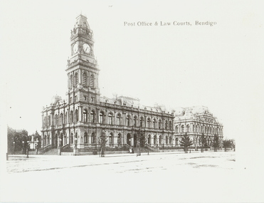
Photograph - POST OFFICE AND LAW COURTS, c1906
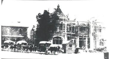
... Black and white photocopy. Public buildings Pall Mall, Post... photocopy. Public buildings Pall Mall, Post Office, Law Courts ...Black and white photocopy. Public buildings Pall Mall, Post Office, Law Courts looking NNE. Original taken c1906 by WH Robinson, Tran in foreground. Two horse drawn carriages. Four pedestrians on footpath. South African War Memorial on left hand foreground. Photograph most likely taken on a Sunday afternoon, because of the lack of traffic. Inscriptions: Post Office and public buildings, Bendigo (printed) History of photograph. First appears? In a 1906 publication by Bolton Bros.WH Robinsonbuildings, government, bendigo post office -
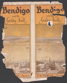 Bendigo Historical Society Inc.
Booklet - Bendigo and the Golden North
... 8537 Booklet presenting the public buildings, churches... presenting the public buildings, churches, recreation facilities ...BHS Collection8537 Booklet presenting the public buildings, churches, recreation facilities, industry and parks and streetscapes of Bendigo in the early 1900s. Booklet is presented in B&W with numerous photographs of buildings and streetscapes of the city off Bendigo.golden north, tourist guide, notable buildings -
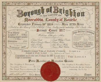 Bayside Gallery - Bayside City Council Art & Heritage Collection
Certificate - Illuminated certificate, Brighton Municipal Certificate, 1872
... of councillors, number of streets, public buildings and institutions... population rates public buildings WP Allen Mayor Town Clerk Surveyor ...bayside city council, borough of brighton, illuminated, certificate, population, rates, public buildings, wp allen, mayor, town clerk, surveyor, councillors, council, borough, county of bourke -
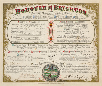 Bayside Gallery - Bayside City Council Art & Heritage Collection
Certificate - Illuminated certificate, Hamel & Fergsuon, Brighton Municipal Certificate, 1866
... list of councillors, number of streets, public buildings... population rates public buildings mayor town clerk surveyor ...bayside city council, borough of brighton, illuminated, certificate, population, rates, public buildings, mayor, town clerk, surveyor, councillors, council, borough, county of bourke, thomas crisp, cr t. crisp, census, parish of moorabbin, hamel & ferguson, coat of arms -
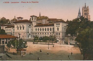 Bendigo Historical Society Inc.
Postcard - ROY AND DORIS KELLY COLLECTION: LAUSANNE, PLACE DE LA RIPONNE, 1900-1920
... is the Palais de Rumine, built in 1902 as a public building housing... as a public building housing the library. Several pedestrians walking ...Postcard, coloured photo of the Place de la Riponne in Lausanne, Switzerland. The main building overlooking the square is the Palais de Rumine, built in 1902 as a public building housing the library. Several pedestrians walking about the square. Spire of a cathedral at top right.postcard, photograph, postcard, lausanne, switzerland, place de la riponne, palais de rumine -
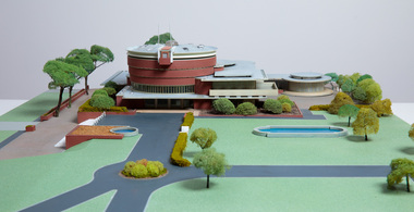 Bayside Gallery - Bayside City Council Art & Heritage Collection
Model, Alan W. Chandler, Brighton Municipal Complex, 1959
... Architectural model of a large public building in orange... model Architectural model of a large public building in orange ...This model of the Brighton Municipal Offices was made by Alan W. Chandler. The Brighton Municipal Offices were designed by Kevin Knight of Oakley and Parkes with the engineers John Connell and Associates and were erected by Prentice Builders Pty Ltd. The foundation stone was laid on 13 February 1959 and the building was opened on 21 July 1961. The interior decoration and furniture was by Grant Featherston. As is common practice, an architectural model was prepared to present the final concept of the building for approval to the Brighton City Council. In February 1959 festivities occurred to celebrate the centenary of the municipality of Brighton. A garden party attended by two hundred Brighton residents was held in the grounds of the Brighton Town Hall. This model graced the centre of the lily pond during the event. The following day the foundation stone of the Brighton Municipal Offices was laid.Architectural model of a large public building in orange brick, the main cylindrical tower is set within a rectangular structure, with circular and oval roof structures. The model is set within landscaped grounds with paths, a water feature, several trees and bushes, lawns and flower beds.brighton municipal complex, brighton civic centre, brighton chambers, architectural model, model, alan w. chandler, kevin knight, oakley and parkes, architecture, municipal offices, municipal building, scale model -
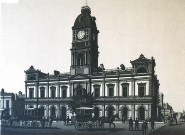
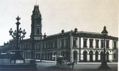
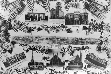 Stawell Historical Society Inc
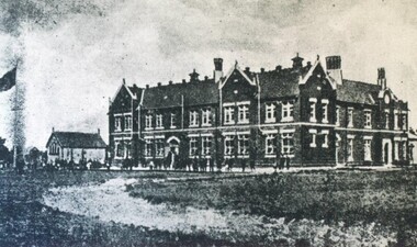
Photograph, Stawell Public Buildings -- Tourist Type Photos 1902 -- Postcard
... Stawell Public Buildings (Tourist Type Photos) 1902... grampians Stawell Public Buildings (Tourist Type Photos) 1902 ...Stawell Public Buildings (Tourist Type Photos) 1902stawell -
 Bendigo Historical Society Inc.
Photograph - JACKSONS CORNER. VIEW POINT. 1875, 1875
... PLACE Building public buildings N. White. Photo. Sandhurst ...Black & white photo of 3 story building - Jacksons Corner at View point in Bendigo. 1 person on 2nd floor. 8 men & 2 young boys standing in front of building. Markings/Inscriptions: Jacksons Corner. View Point. Sandhurst about 1875.N. White. Photo. Sandhurst.place, building, public buildings -
 Bendigo Historical Society Inc.
Document - HARRY BIGGS COLLECTION: MAP - BENDIGO
... PLACE Building public buildings Harry Biggs Collection Map ...Document. Harry Biggs Collection. A very rough hand drawn map of Pall Mall area taking in Police Court, Survey Office, Dudley House, Stockade, Fire Brigade, Camp & commissioners Gully.place, building, public buildings, harry biggs collection, map, bendigo -
 Bendigo Historical Society Inc.
Photograph - HARRY BIGGS COLLECTIO: EAGLEHAWK TOWN HALL
... PLACE Building public buildings Harry Biggs Collection Eaglehawk ...Photograph. Harry Biggs Collection. 3 black & white photos of Eaglehawk Town Hall. The ornate façade of the Town Hall is clearly visible with the clock above. Steps are leading up to the main entrance & a gun turret is at the side.place, building, public buildings, harry biggs collection, eaglehawk town hall -
 Bendigo Historical Society Inc.
Photograph - HARRY BIGGS COLLECTION: EAGLEHAWK TOWN HALL, c1860's (late)
... PLACE Building public buildings Harry Biggs Collection Eaglehawk ...Photograph. Harry Biggs Collection. 2 photos of building the Eaglehawk Town Hall in the late 1860's early 1870's. In the foreground are horse & carts. This is an enlarged photo & a little indistinct with much light. Scaffolding can be seen on the façade. One photo darker & clearer than the other.place, building, public buildings, harry biggs collection, eaglehawk town hall -
 Bendigo Historical Society Inc.
Photograph - HARRY BIGGS COLLECTION: BENEVOLENT ASYLUM BENDIGO
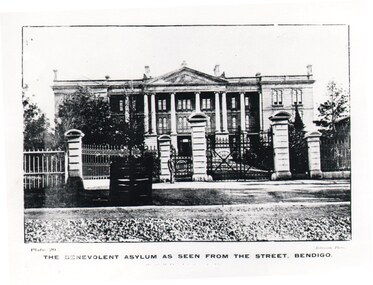
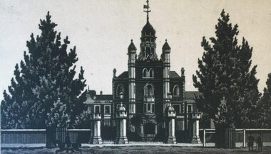
... PLACE Building public buildings Harry Biggs Collection ...Photograph. Harry Biggs Collection. Photo of the Benevolent Asylum as seen from the street, Bendigo. Large ornate building with tall pillars at the front. There is a man standing in the foreground. Plate 20 The Benevolent Asylum as seen from the street, Bendigo (printed under the picture).Robinson Photoplace, building, public buildings, harry biggs collection, the benevolent asylum, bendigo -
 University of Melbourne, Burnley Campus Archives
Photograph - Black and white print, Fred M. Day Press & Commercial Photographer, Poultry Field Day 1954, 1954
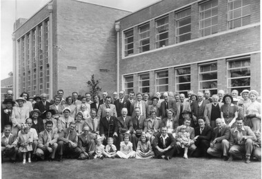
... talbot field day main building public day On reverse, "Poultry ...Note by T.H. Kneen 8 April 1992, "Included in photo: Chief Veterinary Officer of D of A Mr. Talbot seated with walking stick. Second from his left Bill Macauley, Curator Egg-Laying Competition. On his right T.H.K. and kneeling third from right Bill Stanhope Poultry Expert D of A."Black and white photograph. Large group of men, women and children outside the Administration Building. N.U.P.B.A. Field Day (National Union of Poultry Breeders). Also see B91.430.On reverse, "Poultry Field Day 1954 27.2.54." and, "Fred M. Day Press & Commercial Photographer 10 Ailsa Grove Ivanhoe Phone JX 1944."administration building, poultry, chief veterinary officer, bill macauley, curator, egg-laying competition, bill stanhope, poultry expert, mr talbot, field day, main building, public day -
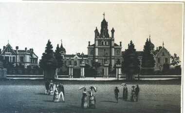
 City of Ballarat Libraries
Photograph, Benevolent Asylum, Ballarat
... Ascot Street South Ballarat Building Public Benevolent Asylum ...The Benevolent Asylum, circa 1870-1880, was located in Ascot Street South. It is now the Queen Elizabeth Geriatric Centre. This sketch comes from the Premier Album of Ballarat Views.benevolent asylum, queen elizabeth geriatric centre, ascot street south, ballarat, building, public -
 City of Ballarat Libraries
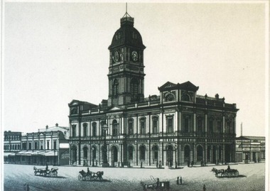
Photograph, Ballarat Town Hall
... the Premier Album of Ballarat Views. Town Hall Ballarat Building ...Ballarat Town Hall circa 1870-1880 from the Premier Album of Ballarat Views.town hall, ballarat, building, public, premier album of ballarat view -
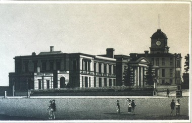
 City of Ballarat Libraries
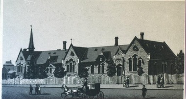
Photograph, Central State School, Ballarat West
... . Building Public school education Central State School Dana Street ...The Central State School no. 33, Ballarat West circa 1870-1880 from the Premier Album of Ballarat Views. We know this school today as Dana Street Primary School.building, public, school, education, central state school, dana street primary school, premier album of ballarat views, ballarat -
 City of Ballarat Libraries
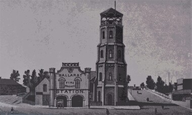
Photograph, Ballarat Fire Station, Ballarat East
... Building Public Ballarat East Barkly Street Premier Album ...The Ballarat Fire Station, Ballarat East circa 1870-1880 from the Premier Album of Ballarat Views. The building still stands in Barkly Street.ballarat fire station, building, public, ballarat east, barkly street, premier album of ballarat views -
 City of Ballarat Libraries
Photograph, East Ballarat Town Hall, Police Offices and Library
... Building Public barkly street Premier Album of Ballarat Views East ...The library building still stands in Barkly Street but the Town Hall and Police Offices are no longer there. This sketch comes from from the Premier Album of Ballarat Views circa 1870-1880. ballarat east, town hall, police offices, library, building, public, barkly street, premier album of ballarat views -
 City of Ballarat Libraries
Photograph, Town Hall, Ballarat circa 1870s
... by Niven & Co. Building Public Town Hall ballarat sturt street ...This sketch comes from Views of Ballarat by Niven & Co.building, public, town hall, ballarat, sturt street, views of ballarat -
 City of Ballarat Libraries
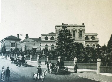
Photograph, Post Office Building and Burke & Wills Monument, Ballarat circa 1885
... Album of View by Niven & Co. Building Public Monuments Post ...The Post Office building is located on the corner of Sturt and Lydiard Street North. This sketch comes from Album of View by Niven & Co.building, public, monuments, post office, burke & wills, ballarat, views of ballarat -
 City of Ballarat Libraries
Photograph, Benevolent Asylum, Ballarat
... . Building Public Benevolent Asylum Ascot Street South Ballarat Views ...The Benevolent Asylum was on Ascot Street South. It is now the Queen Elizabeth Geriatric Centre. This sketch comes from View of Ballarat by Niven & Co circa 1885.building, public, benevolent asylum, ascot street south, ballarat, views of ballarat -
 City of Ballarat Libraries
Photograph, Hospital, Ballarat circa 1885
... & Co. Building Public Hospital Drummond Street North Ballarat ...The hospital is located in Drummond Street North. It may be the site of the current St John of God Hospital. The building with the tower is still standing although, the tower has been removed. The sketch comes from Views of Ballarat by Niven & Co.building, public, hospital, drummond street north, ballarat, views of ballarat -
 City of Ballarat Libraries
Photograph, Ballarat State School
... by Niven & Co circa 1885. building public school ballarat state ...The Ballarat State School became the Urquhart Street State School and the building is now used by Brace Education and Training. The sketch comes from Views of Ballarat by Niven & Co circa 1885.building, public, school, ballarat state school, urquhart street state school, views of ballarat -
 City of Ballarat Libraries
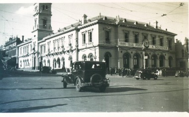
Photograph, Ballarat Post Office during Ballarat Centenary Celebrations 1938
... -1938. building public post office centenary ballarat Ballarat ...Post Office decorated for Centenary 1838-1938.building, public, post office, centenary, ballarat -
 City of Ballarat Libraries
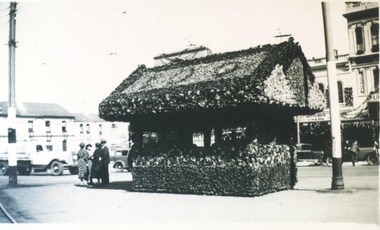
Photograph, Tram Shelter during Ballarat Centenary Celebrations 1938
... and Butler's Cake Shop can be seen in the background. building public ...Tram Shelter decorated for Centenary Celebrations 1938. Located in Sturt Street. The Union Hotel and Butler's Cake Shop can be seen in the background.building, public, tram, transport, centenary, ballarat, hotel, commercial -
 City of Ballarat Libraries
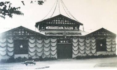
Photograph, Wendouree Rowing Club Boatshed decorated for Ballarat Centenary celebrations 1938
... boatshed building public centenary Wendouree Rowing Club Boatshed ...lake wendouree, wendouree rowing club, boatshed, building, public, centenary -
 City of Ballarat Libraries
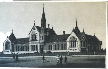
Photograph, Ballarat Grammar School 1915
... . This picture comes from the publication, Beautiful Ballarat. building ...The Ballarat Grammar School in located in Forest Street, Wendouree. A small timber chapel can also be seen. This picture comes from the publication, Beautiful Ballarat.building, public, school, education, ballarat grammar, forest street, wenduree, chapel