Showing 173 items matching "railway road greensborough"
-
 Greensborough Historical Society
Photograph - Digital Image, Marilyn Smith, Mernda Station 2018, 27/09/2018
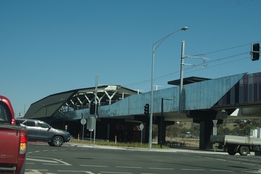
In 2018 GHS members visited Turner's Bakery in Mernda for lunch and continued on to visit historic sites remaining in the Mernda area. This photograph shows the newly built Mernda Station, part of the railway extension on the old Epping line. This station was opened in August 2018. Mernda is now the end of the line. It is sited on corner Bridge Inn Road and Schotters Road. Mernda is an area of rapid modern growth with a few remaining historic buildings dating from the 19th century.Digital copy of colour photographmernda, mernda historic sites, schotters road mernda, mernda station, bridge inn road mernda -
 Greensborough Historical Society
Photograph - Digital Image, Plenty Bridge Hotel Lower Plenty c1910, 1910s
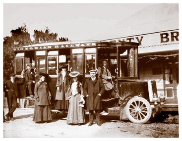
Plenty Bridge Hotel Lower Plenty, 1910s. This photograph shows a group of travellers with a Victorian Railways bus outside the Plenty Bridge Hotel circa 1910. A day trip to the countryside was a popular pastime for city dwellers.Digital copy of black and white photographlower plenty, plenty bridge hotel, lower plenty hotel, victorian railways -
 Greensborough Historical Society
Photograph - Digital Image, Watsonia Railway Station 1975, 1975_
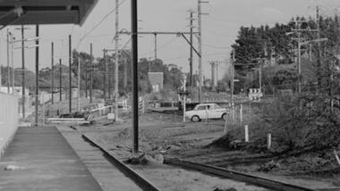
Watsonia rail line being moved below road level mid 1970s. This photograph shows work on the cutting and beginning of station. Watsonia Station was opened in 1977 when the rail line was lowered to remove level crossings and duplicate the line between Macleod and Greensborough.Digital copy of colour photographwatsonia station, hurstbridge rail line -
 Greensborough Historical Society
Photograph - Digital Image, Watsonia Railway Station before 1970, 1960s
Watsonia Station before the 1970s. This photograph shows the old station. The new Watsonia Station was opened in 1977 when the rail line was lowered to remove level crossings and duplicate the line between Macleod and Greensborough.Digital copy of black and white photographwatsonia station, hurstbridge rail line -
 Greensborough Historical Society
Photograph - Digital Image, Watsonia Railway Station before 1970, 1960s
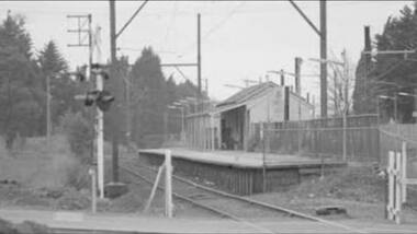
Watsonia Station before the 1970s. This photograph shows the rail crossing at the old station. The new Watsonia Station was opened in 1977 when the rail line was lowered to remove level crossings such as this and duplicate the line between Macleod and Greensborough.Digital copy of black and white photographwatsonia station, hurstbridge rail line -
 Greensborough Historical Society
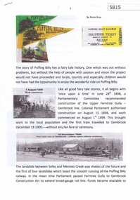
Article, Rosie Bray, Puffing Billy, by Rosie Bray, 18/10/2018
Short history of the Puffing Billy Railway, from the 1900 Upper Ferntree Gully - Gembrook railway line to its rebirth in 1955, operating between Belgrave and Menzies Creek, later extended to Gembrook. Written to commemorate the 20th anniversary and the official re-opening of the Lakeside to Gembrook line on October 18, 2018.4 p. typescript with col. photographspuffing billy railway -
 Greensborough Historical Society
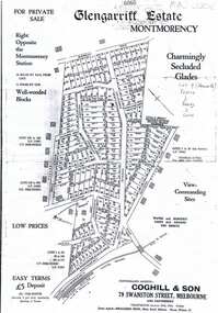
Plan, Coghill and Son, Glengarriff Estate Montmorency, 1938c
Plan for the Glengarriff Estate covers 171 lots in vicinity of Montmorency Railway Station, for private sale, controlling agents Coghill & Son, Local Agents Shallard Bros, Main Road Eltham. C/T 6068/1213512 formerly owned by George Nicholson, dentist.Black and white photocopy of a real estate agent's plan of subdivision montmorency, glengarriff estate montmorency, calrossie street montmorency -
 Greensborough Historical Society
Map, Melbourne and Metropolitan Board of Works. Survey Division, MMBW, Yarra 2500 / 12.20. Watsonia Railway Station and environs, 1983_03
Melbourne and Metropolitan Board of Works. Yarra 2500 [base map]. 12-20, Parishes of Keelbundora 2856, Municipalities of Diamond Valley 257 and 228. Shows street names, easement sizes, lot numbers, lodged plan numbers, names of prominent features, contour values, creek or river names. Watsonia Railway Station and environs. Prominent streets: Watsonia Road, Elder Street, Morwell Avenue and Nepean Street. Includes former Watsonia Technical School and Gresswell Rehabilitation Centre sites.MMBW Map in 1:2500 [scale] series. Cream parchment with green tape reinforcing on edges and punched holes on left edge.mmbw, melbourne and metropolitan board of works, shire of diamond valley, watsonia - maps -
 Greensborough Historical Society
Map, Melbourne and Metropolitan Board of Works. Survey Division, MMBW, Yarra 2500 / 12.22. Watsonia North, 1978_03
Melbourne and Metropolitan Board of Works. Yarra 2500 [base map]. 12-22, Parishes of Keelbundora 2856, Municipalities of Whittlesea 239 and Diamond Valley 257. Shows street names, easement sizes, lot numbers, lodged plan numbers, names of prominent features, contour values, creek or river names. Watsonia Railway Station and environs. Prominent streets: Edmund Rice Parade and Macorna Street. Includes Christian Brothers Edmund Rice College and Janefield Special School sites and "proposed future freeway" (now Metropolitan Ring Road).MMBW Map in 1:2500 [scale] series. Cream parchment with green tape reinforcing on edges and punched holes on left edge.mmbw, melbourne and metropolitan board of works, shire of diamond valley, watsonia - maps, bundoora - maps -
 Greensborough Historical Society
Map, Melbourne and Metropolitan Board of Works. Survey Division, MMBW, Yarra 2500 / 12.21. Watsonia North, 1979_02
Melbourne and Metropolitan Board of Works. Yarra 2500 [base map]. 12-22, Parish of Keelbundora 2856, Municipality of Diamond Valley 257. Shows street names, easement sizes, lot numbers, lodged plan numbers, names of prominent features, contour values, creek or river names. Watsonia Railway Station and environs. Prominent streets: Grimshaw Street, William Street and Macorna Street. Includes former Institute of Social Welfare (now Loyola College) Lines Reserve and Binnak Park.MMBW Map in 1:2500 [scale] series. Cream parchment with green tape reinforcing on edges and punched holes on left edge.mmbw, melbourne and metropolitan board of works, shire of diamond valley, watsonia - maps, bundoora - maps -
 Greensborough Historical Society
Map, Melbourne and Metropolitan Board of Works. Survey Division, MMBW, Yarra 2500 / 12.24. Plenty and Blue Lake, 1977_10
Melbourne and Metropolitan Board of Works. Yarra 2500 [base map]. 12-24, Municipalities of Whittlesea 239 and Diamond Valley 257. Shows street names, easement sizes, lot numbers, lodged plan numbers, names of prominent features, contour values, creek or river names. Watsonia Railway Station and environs. Prominent streets: Memorial Drive. Includes Plenty River and Blue Lake in the Plenty Gorge.MMBW Map in 1:2500 [scale] series. Cream parchment with green tape reinforcing on edges and punched holes on left edge.mmbw, melbourne and metropolitan board of works, shire of diamond valley, plenty - maps, blue lake -
 Greensborough Historical Society
Map, Melbourne and Metropolitan Board of Works. Survey Division, MMBW, Yarra 2500 / 17.26. Hurstbridge, 1978_01
Melbourne and Metropolitan Board of Works. Yarra 2500 [base map] 17-26. Hurstbridge. Municipalities of Diamond Valley 257 and Eltham 238. Prominent streets include: Flat Rock Road and Heather Avenue. Includes Hurstbridge Railway Station.MMBW Map in 1:2500 [scale] series. Cream parchment with green tape reinforcing on edges and punched holes on left edge.mmbw, melbourne and metropolitan board of works, shire of diamond valley, hurstbridge - maps -
 Greensborough Historical Society
Newspaper Clipping, Train works steam ahead, 05/06/2019
Rail will be duplicated to Eltham and a major bus interchange created at Greensborough under a $547 million public transport cash splash.News article 1 page, black text.eltham railway duplication, greensborough -
 Greensborough Historical Society
Map, Heidelberg: Historic River Landscape Assessment. Historical maps. Map E 1901-1934 "A Time of projects and improvements", 1985c
Geographical area of around 35 sq. kilometres marked with physical features such as major roads, railways (new extension to Eltham), rivers and properties, also housing sub-divisions and community facilities such as hospitals, parks and sporting reserves and indications of new small scale industries such as dairying. Bounded by Shire of Diamond Valley to the North, Darebin Creek to the West and Plenty River to the East. Black and white sketch map on white paperheidelberg, heidelberg - maps -
 Greensborough Historical Society
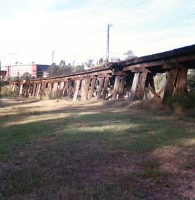
Photograph, Trestle Bridge Eltham April 1979, 17/04/1979
A photograph of the railway trestle bridge at Eltham. Built in 1902, it is the only railway bridge of predominantly timber construction that is still in regular use. The bridge is listed on the Victorian Heritage Database.1 colour photograph.peter graham, eltham, trestle bridge eltham -
 Greensborough Historical Society
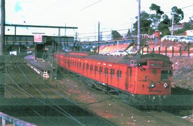
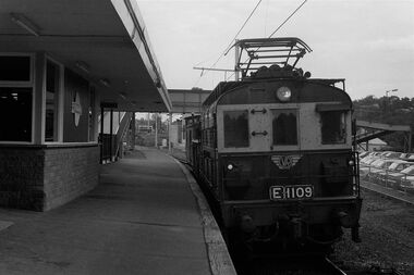
Photograph, Greensborough Station, 1980s, 24/08/2018
Photograph is of Tait train (Red Rattler) leaving Greesnsborough Station in the 1980s1 p., colour photograph and caption by Raymond Marshgreensborough railway station -
 Greensborough Historical Society
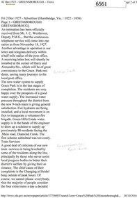
Newspaper Clipping (copy), Greensborough. 2 Dec 1927, 02/12/1927
Article describing new utilities in the Greensborough district: continuous telephone service; letter and telegram delivery within a half-mile radius of the post office; new water system to supply Grace Park, and plans to supply water to the Greenhills Estate, and comments on the train service from Heidelberg to Eltham.2 p. typescript (OCR transcript of original article, copied from Trove)water supply, postal services, railways, greenhills, grace park, telephone service, greensborough -
 Greensborough Historical Society
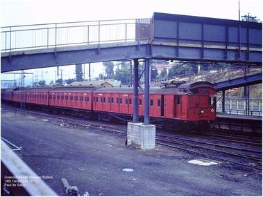
Photograph - Digital Image, Paul de Sauty, Greensborough Railway Station 1975, 14/12/1975
Photograph of Greensborough Railway Station, December 1975.Digital copy of colour photograph.greensborough railway station, trains -
 Greensborough Historical Society
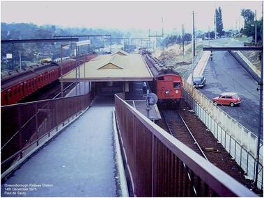
Photograph - Digital Image, Paul de Sauty, Greensborough Railway Station, ramp to station, 1975, 14/12/1975
Photograph of the ramp at Greensborough Railway Station, December 1975.Digital copy of colour photograph.greensborough railway station, trains -
 Greensborough Historical Society
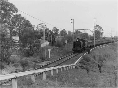
Photograph - Digital Image, Paul de Sauty, Greensborough, 1967, 26/08/1967
Photograph of train line Greensborough, 1967.Digital copy of colour photograph.paul de sauty, greensborough railway station, trains -
 Greensborough Historical Society
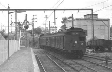
Photograph - Digital Image, Paul de Sauty, Tait 'red rattler' at Greensborough Railway Station 1960s, 1960s
Photograph of a Tait ' red rattler' (with sliding door) at Greensborough Railway Station in the 1960s. In the background are coal trucks in the siding, the station master's house, and under the train is the foot crossing, prior to the overpass.Digital copy of black and white photograph.greensborough railway station, trains -
 Greensborough Historical Society
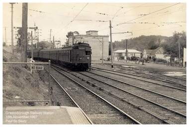
Photograph - Digital Image, Paul de Sauty, Greensborough Railway Station 1967, 18/11/1967
Photograph of train at Greensborough Railway Station in 1967. In the background are the station master's house behind the train, with the Higgins and Leaford houses in back right.Digital copy of black and white photograph.greensborough railway station, trains -
 Greensborough Historical Society
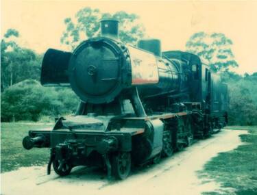
Photograph - Digital Image, Steam train in Poulter Reserve, Greensborough, 1980s, 1980s
Photograph of retired steam train at Poulter Reserve Greensborough in the 1980s. This train was used as a playground attraction.Digital copy of colour photograph.greensborough railway station, trains, poulter reserve greensborough -
 Greensborough Historical Society
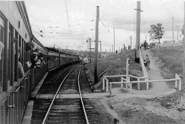
Photograph - Digital Image, Train at Greensborough Railway Station 1960s, 1960s
Photograph of a train approaching Greensborough Railway Station in the late 1960s. Note the foot crossing under the train, prior to the overpass.Digital copy of black and white photograph.greensborough railway station, trains -
 Greensborough Historical Society
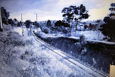
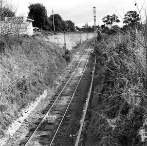
Photograph - Digital Image, Single train track in the cutting at Greensborough 1970s, 1970s
Photograph of the single track approaching Greensborough Railway Station in the 1970s. This view is from behind the station master's house. On the hill to the left is Connie Burkett's hair salon in the Valley Buildings.Digital copy of black and white photograph.greensborough railway station, trains, main street greensborough, connie burkett -
 Greensborough Historical Society
Photograph - Digital Image, Upgrades to Greensborough Station 1970, 1970_
Photograph of construction of the new station at Greensborough. The existing track can be seen plus construction of a second track, making the station an island platform. The new station was opened on 03/04/1970.Digital copy of black and white photograph. trains, greensborough railway station -
 Greensborough Historical Society
Photograph - Digital Image, Greensborough Railway Line, 1970_
Photograph of the rail line approaching Greensborough. This is behind the current RSL, looking towards the Pinehills Estate.Digital copy of black and white photograph. trains, greensborough railway station, pinehills estate -
 Greensborough Historical Society
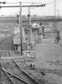
Photograph - Digital Image, Gantries and electricals, Greensborough Station 1970, 1970_
Photograph of construction of the new station at Greensborough. This shows gantries and overhead electricals. The photo is taken from the station master's house looking toward the station and sidings. The new station was opened on 03/04/1970.Digital copy of black and white photograph. trains, greensborough railway station -
 Greensborough Historical Society
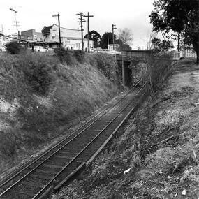
Photograph - Digital Image, Rail cutting approaching Greensborough Station 1970, 1970_
Photograph of the rail cutting approaching Greensborough Station. Looking toward Church Street, with Watson's car yard on the left. Photo taken when widening cutting.Digital copy of black and white photograph. trains, greensborough railway station, church street greensborough -
 Greensborough Historical Society
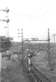
Photograph - Digital Image, Electric freight train at Greensborough Station 1970s, 1970s
Photograph of an electric freight train with caboose at Greensborough Station, c1970s. Digital copy of black and white photograph. trains, greensborough railway station, freight trains