Showing 41 items matching "rattray road montmorency"
-
 Eltham District Historical Society Inc
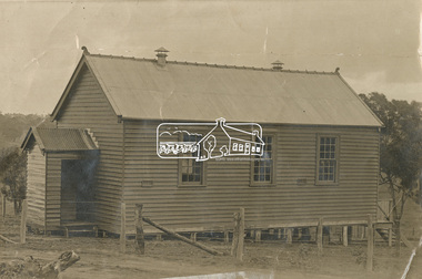
Photograph - Sepia Print, Unidentified hall; possibly the Montmorency Presbyterian Church Hall, Rattray Road, Greensborough, c.1918
... Church Hall, Rattray Road, Greensborough.... Montmorency Montmorency Presbyterian Church Hall Rattray Road Sepia ...From Eltham Montmorency Uniting Church, History http://www.elthammontmorencyuca.org/history/ In 1914 a small group of Presbyterians living on 'The Montmorency Estate', which had been established when the railway was extended to Eltham several years before, began meeting for worship in the Rattray Rd home of Robert Sharpe. Two years later a small weatherboard church, administered from Scots Church, Heidelberg, was built on land donated by Mr. Sharpe. In 1931 this building was moved to the corner of Rattray Road and Mountain View Roads. In the next few years local elders were elected and the congregation adopted the name St. Andrew’s Presbyterian Church, Montmorency.montmorency, montmorency presbyterian church hall, rattray road -
 Eltham District Historical Society Inc
Slide - Photograph, Eltham Shire Council, Plan of Subdivision, Part of Crown Portion 3, Parish of Nillumbik, County of Bourke, 1969
... melbourne Infrastructure Map Montmorency planning Rattray Road ...35mm colour positive transparency blue Agfacolour Service plastic mountC5C, Delbridge, 4 lots, Rattray Road, 4 August 1969infrastructure, map, montmorency, planning, rattray road, subdivison lots, reichelt avenue -
 Eltham District Historical Society Inc
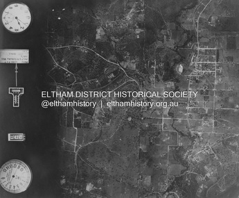
Photograph - Aerial Photograph, Landata, Eltham and Montmorency, Nov. 1931
... Belmont Reserve Montmorency Rattray Road Digital tif ...Centred over present-day Belmont Reserve, Montmorency Historic Aerial Imagery Source: Landata.vic.gov.au Aerial Photo Details: Project No :1931 Project : MALDON PRISON Run : 19 Frame : 3130 Date : 11/1931 Film Type : B/W Camera : F8 Flying Height : 11000 Scale : 18860 Film Number : 60 GDA2020 : 37°43'13"S, 145°07'54"E MGA2020 : 335330, 5823576 (55) Melways : 21 F6 (ed. 42)aerial photo, eltham, neil webster collection, belmont reserve, montmorency, rattray road -
 Eltham District Historical Society Inc
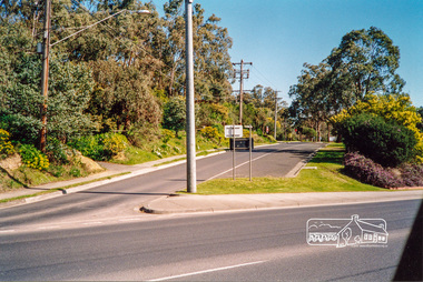
Photograph, Rattray Road access from Sherbourne Road, Montmorency opposite the 7-Eleven and Eltham Fort Knox, c.July 1991, 1991
... . montmorency streets rattray road sherbourne road Colour photograph ...Opposite the Shire Council Depot (formerly Fayrefield Hat Factory and now Eltham Fort Knox). Comment from David Taylor (via Facebook 2/4/2018): My family home was at 216 Rattray and I remember Powell's old garage on the right where the servo is now decades before the road was excavated. They had an aviary (very exciting for a very young child) and hand pumped kerosene.Colour photographmontmorency, streets, rattray road, sherbourne road -
 Eltham District Historical Society Inc
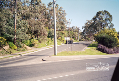
Photograph, Rattray Road access from Sherbourne Road, Montmorency opposite the 7-Eleven and Eltham Fort Knox, c.July 1991, 1991
... . montmorency rattray road sherbourne road streets Fuji 100 Roll of 35mm ...Opposite the Shire Council Depot (formerly Fayrefield Hat Factory and now Eltham Fort Knox). Comment from David Taylor (via Facebook 2/4/2018): My family home was at 216 Rattray and I remember Powell's old garage on the right where the servo is now decades before the road was excavated. They had an aviary (very exciting for a very young child) and hand pumped kerosene.Roll of 35mm colour negative film, 4 stripsFuji 100montmorency, rattray road, sherbourne road, streets -
 Greensborough Historical Society
Oral History Transcript, Myrtle Barnett 19/02/1996, 19/2/1996
Oral history Myrtle Barnett ( 1915- ); fostered daughter of Caroline & Ferdinand Barnett; Lower Plenty. Interviewed on 19 Feb 1996 by Peter Blackbourn. "We lived at Grace Park and could walk straight down the road and over the bridge to the Montmorency State School. The school was in Rattray Rd about half way up the hill. The King family lived next door to the school. One day the students were all taken on a walk to choose the site of the new school (which was built in 1924). In addition to the above story; Myrtle said at either the Lower Plenty School or the Montmorency School there was a teacher they didn’t like so they swapped schools. My Grandmother Jean Barnett; started at Greensborough Primary in 1919 and stayed 3 months. When I told her about this; she told me off and said she never went there! She must have then gone to Montmorency and when there was a call to start a school at Lower Plenty; took the opportunity to get away from the teacher they didn’t like. I’m not sure of the time line for the above events; or which school they swapped to but I thought it gave a little insight into the 1920’s and how Lower Plenty; Montmorency and Greensborough were connected."Transcript of Oral History. barnett family, myrtle barnett -
 Greensborough Historical Society
Newspaper clipping, Feedback call for park plans, 29/07/2015
Banyule Council asked for community feedback on the draft master plan for Petrie Park and Rattray Reserve.News clipping, black text.montmorency, petrie park, rattray reserve -
 Eltham District Historical Society Inc
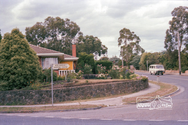
Photograph, Marjorie North, Montmorency Shopping Centre sign, corner of Rattray and Looker Roads, 8 Feb 1986, 1986
... for Montmorency France album montmorency looker road rattray road shopping ...Negatives supplied by Marjorie North 1 July 1986 for Montmorency France albumRoll of 35mm colour negative film, 4 of 6 stripsKodak CP 100 5094montmorency, looker road, rattray road, shopping centre -
 Eltham District Historical Society Inc
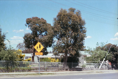
Photograph, Marjorie North, Montmorency State Primary School facing Rattray Road, 1985, 1986
... rattray road Kodak CL 200 5093 Roll of 35mm colour negative film ...Negatives supplied by Marjorie North 1 July 1986 for Montmorency France albumRoll of 35mm colour negative film, 3 stripsKodak CL 200 5093montmorency, montmorency state primary school, rattray road -
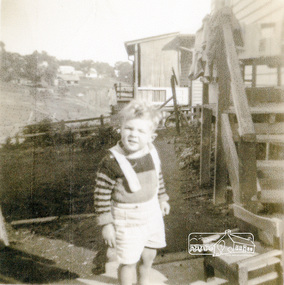 Eltham District Historical Society Inc
Photograph, Graeme Landy (approx. 3); looking south from the backyard of 38 Beattie Street, Montmorency, towards Rattray Road, c.1952, 1952c
... of 38 Beattie Street, Montmorency, towards Rattray Road, c..., towards Rattray Road, c.1952 Photograph ...Digital copy of black and white photograph38 beattie street, graeme landy, montmorency -
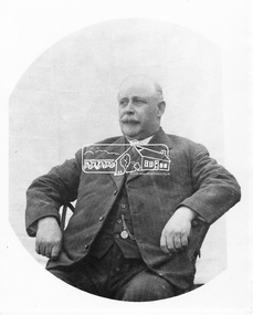 Eltham District Historical Society Inc
Photograph, Councillor Albert Henry Charles Price
Albert Price (1860- 1945) purchased a 31 acre block of the Montmorency subdivision. From 1911 to 1922 he was a member of the Heidelberg Shire Council and was later President of that shire. He then became the first Councillor representing Montmorency within the Shire of Eltham. He served from 1925 to 1945. He was President of the Shire five times. His achievements included bringing electric light and water into Eltham, Montmorency and Briar Hill, the improvement to the train service, together with the construction of a station at Montmorency. He was a member of the Montmorency State School committee and was also a mason. He died in May 1945 aged 85 years while still being a serving councillor. He is buried at Fawkner Cemetery. His name is remembered in the naming of Price Avenue, Montmorency. A memorial plaque was placed in the original Memorial Hall in Rattray Road in memory of Albert and Janet Price's commitment to the new suburb of Montmorency. This photo forms part of a collection of photographs gathered by the Shire of Eltham for their centenary project book, "Pioneers and Painters: 100 years of the Shire of Eltham" by Alan Marshall (1971). The collection of over 500 images is held in partnership between Eltham District Historical Society and Yarra Plenty Regional Library (Eltham Library) and is now formally known as 'The Shire of Eltham Pioneers Photograph Collection.' It is significant in being the first community sourced collection representing the places and people of the Shire's first one hundred years.Digital imagesepp, shire of eltham pioneers photograph collection, councillor price, montmorency, albert price, portrait