Showing 53 items
matching rifle range road
-
 Eltham District Historical Society Inc
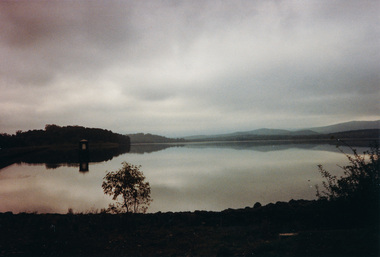
Photograph, Sugarloaf Reservoir from Skyline Drive, 1989, 1989
Originally contained in a 'magnetic' photo album believed to have been donated by Mr Eric Stephenson, Jingalong, 110 Ryans Road, Eltham, Vic. 3095; relocated to archival safe storage. Sugarloaf Reservoir is situated on former farmland. This large water storage was completed in 1982 and serves Melbourne's northern suburbs. Within the visitor areas are two picnic grounds and other recreational facilities. Below its massive rock embankment is located the Winnecke Treatment Plan designed to purify its water before being piped into Melbourne. The dam partly inundated the old firing ranges of the former Christmas Hills Rifle Club. Source: Christmas Hills Now and then: Yarra Glen & District Historical Society, 2004. Two colour photographsskyline drive, sugarloaf reservoir -
 Federation University Historical Collection
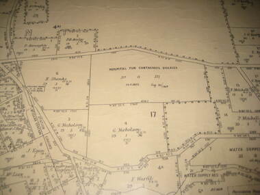
Plan - Plan - Cadastral, Parish of Ballaarat - Sheet 3 (only), 03/03/1932
Sheet 3 of the Parish of Ballart showing Government roads, crown allotments, dimensions, crown grantees, date of grants, etc,ballarat, plan, hospital for contagious diseases, sebastopol, sebastopol rifle range, fiscalini, leigh river, yarrowee creek -
 Glenelg Shire Council Cultural Collection
Photograph - Photograph - Point Danger and rifle range, n.d
Port of Portland Authority Archivesport of portland archives, point danger -
 Ringwood and District Historical Society
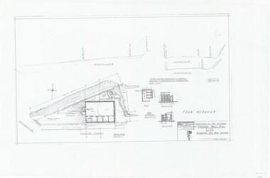
Plan, Drill Hall Site - Design for Military Units and Miniature Rifle Range, Ringwood, Victoria - Circa 1935
Technical drawings (a) Block Plan - Ringwood Drill Hall Site, Station Street, Ringwood. (b) Plan View, End and Side Elevation, Drill Hall Wodonga - Removed to Ringwood. (c) Plan View, Front and Rear Elevations, Minature Rifle Range at Ringwood Drill Hall.Commonwealth of Australia. Department of The Interior, Works & Services Branch, Victoria. -
 Bendigo Historical Society Inc.
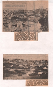
Newspaper - NEWSPAPER CLIPPINGS EARLY PHOTOGRAPHS OF BENDIGO STREETSCAPE, Unknown
Two Black & White Early Photographs of Bendigo. (Photograph 1) Panorama is taken from the Masonic Hall location with the Rifle Brigade Hotel on the corner of Rowan and View Streets and Knipe's Folly in top right of image. (Photograph 2) An early photograph of the Bendigo Goldfields the suburb of Ironbark taken from the vicinity of Mt. Korong Road, overlooking Victoria Street and Quick Street. Image shows Knipe's Castle in Boundary Street ''on the Ironbark Ranges'' top right.bendigo, streetscape, rowan & view st, mt korong rd -
 Peterborough History Group
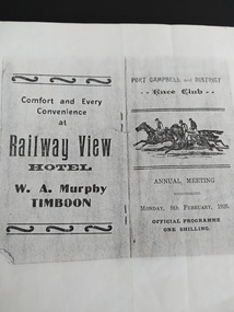
Booklet - Race Card, Port Campbell and District Race Club Annual Meeting Monday 8th February 1926
Race programme for horse racing event at the Port Campbell race track, located near Two Mile Bay, where the rifle range is now located. Lists horses and owners. Includes advertising for local businesses at the time.Significant as it indicates sporting and social activities in 1926. Photocopy of original race programme at the Port Campbell Racetrack.port campbell horse racing, port campbell race track, railway view hotel timboon, port campbell hotel, cobden hotel, 1926 -
Whitehorse Historical Society Inc.
Document, Bus tour itinerary 2012, 1/03/2012 12:00:00 AM
Proposed itinerary for tour of Whitehorse during Heritage Week 2012:Proposed itinerary for tour of Whitehorse during Heritage Week 2012: incl. Community Gardens, Tally Ho Boys Home, Rifle Range, Doncaster orchards and Morack Golf Course. The tour did not eventuate.Proposed itinerary for tour of Whitehorse during Heritage Week 2012:heritage week 2012, community garden, rifle range, doncaster orchards -
 Mt Dandenong & District Historical Society Inc.
Photograph, Members of the Olinda Rifle Club
Hazy photograph of Olinda and Mt Dandenong men at the Olinda Rifle Range 1909.olinda, rifle range -
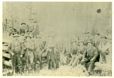
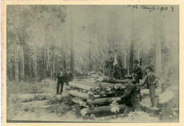 Mt Dandenong & District Historical Society Inc.
Photograph, Olinda Rifle Range 1903
Scene showing 12 men at the Olinda Rifle Range in 1903. One man firing rifle. Reverse of photograph has handwritten description by John Lundy-Clarke.The Rifle Range at Olinda 1903. Was in the area of the Rhododendron Gardens by Georgian Road and the GolfLinks.olinda, rifle range -
 Bendigo Historical Society Inc.
Document - PETER ELLIS COLLECTION: A GUIDE FOR DRIVERS ON THE WHIPSTICK TOUR
A Guide for Drivers on the Whipstick Tour. First page gives assembly area, driving in convoy and negotiating water or boggy patches across the road. Amended written at the end of the page. Directions with mileage and items of interest for the tour on Sunday September 9th (no year). A Whipstick Map 1971 showing State Forest, Crown Lands, Uncleared Mallee - Private (shown in different colours) Water Reserve and Roads. Noted are Flora and Fauna - Plants, Birds & Mammals, and areas of State Forest and Southern State Forest with Mallee Scrub area noted. Also State Forest & Crown Lands Total Area and a map scale. The Bendigo Whipstick mentions area, suggestions of where the name Whipstick came from, shrubs and flowers with their flowering times, descriptions of some of them and some information on the Mallee Fowl. The Eucalyptus Oil Industry paragraph mentions the beginnings of the industry. Mentioned are the different uses of oils (perfumery, industrial and medicinal) and the different species of eucalypt used for each and various products. Also notes on the growing, harvesting and refining of eucalyptus. P Ellis at the end of the page. The next two and a half pages mentions reserves, and at the end acknowledgements. Includes a spare copy of 'The Bendigo Whipstick' by P Ellis.bendigo, history, early bendigo, peter ellis collection, a guide for drivers on the whipstick tour, the whipstick 1971 map, shire of marong, shire of east loddon, shire of huntly, borough of eaglehawk, city of bendigo, shire of strathfieldsaye, the bendigo whipstick, eucalyptus oil industry, eaglehawk town hall, lightning hill lookout, eaglehawk rifle range, new moon mines, blue jacket reservoir, maggetti's wine hall, camp hotel (ex), skylark dam, eucalyptus oil production, eucalyptus factory, whipstick eucalyptus farm, ruedin's eucalyptus factory, dutch bowls, governor philip, sir joseph banks, john white, baron von mueller, joseph bosisto, commonwealth government, perfumery oils, industrial oils, medicinal oils, p ellis, dr frith, csiro wildlife division, harley webster, forests commission, vincent serventy, victorian national parks association, bendigo field naturalists club -
 Vision Australia
Document - Text, Rifle Club papers, 1966-2003
A collection of papers made by Betty Williamson for a presentation at RVIB, and includes newspaper articles as well as a potted history of the Club. In the 1960's, the RVIB approached engineer George Glover to produce equipment to allow blind people to shoot, based upon that made available at St Dunstan's Hospital in the UK. The rifle range opened in February 1966 at the rear of St Kilda Road with 30 members, and soon became involved in matches with sighted rifle clubs in the area. The club had many successful years, competing against teams from Canada and New Zealand in 1968, and had the support of ICIANZ which provided them with free munitions as well as teams to compete against. In 1977, George Glover passed away and some of the skills required for maintenance of the equipment was lost, however the club continued until the late 1980's/early 1990s.1 folder of papers and pennantsrvib rifle club, george glover -
 Vision Australia
Badge - Object, RVIB Rifle Club badge
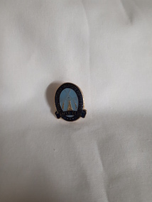
This badge has 'Royal Victorian Institute for the Blind' written in gold against a dark blue background around an oval shape, with the words 'Rifle Club' in the same lettering at the base. Inside the oval, on a light blue background, is a lighthouse and a rifle either side of it, the butts crossing at the apex. In the 1960's, the RVIB approached engineer George Glover to produce equipment to allow blind people to shoot, based upon that made available at St Dunstan's Hospital in the UK. The rifle range opened in February 1966 at the rear of St Kilda Road with 30 members, and soon became involved in matches with sighted rifle clubs in the area. The club had many successful years, competing against teams from Canada and New Zealand in 1968, and had the support of ICIANZ which provided them with free munitions as well as teams to compete against. In 1977, George Glover passed away and some of the skills required for maintenance of the equipment was lost, however the club continued until the late 1980's/early 1990s.Lighthouse with two rifles either side and crossed at top on blue backgroundRoyal Victorian Institute for the Blind Rifle Clubroyal victorian institute for the blind, badges, rvib rifle club -
 Vision Australia
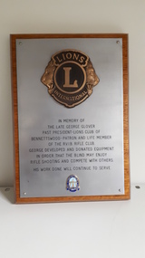
Photograph - Image, Commemorative plaque : Glover
At the top of the shield is a Lions International symbol consisting of two lions heads facing outwards either side of the words 'Lions International' and the letter 'L' in between them. At the base of the shield is a blue and gold coloured badge, consisting of two rifles crossed in front of the RVIB lighthouse, with the words 'Royal Victorian Institute for the Blind Rifle Club' around the outside. Between the two symbols is engraved "In memory of the late George Glover Past President-Lions Club of Bennettswood - Patron and Life Member of the R.V.I.B. Rifle Club. George developed and donated equipment in order that the blind may enjoy rifle shooting and compete with others. His work done will continue to serve." In the 1960's, the RVIB approached engineer George Glover to produce equipment to allow blind people to shoot, based upon that made available at St Dunstan's Hospital in the UK. The rifle range opened in February 1966 at the rear of St Kilda Road with 30 members, and soon became involved in matches with sighted rifle clubs in the area. Passionate about the sport, Mr Glover continued work and supporting the club until his death in 1977.1 wooden shield with engraved silver plategeorge glover, rvib rifle club -
 Vision Australia
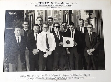
Photograph (item) - Object, RVIB Rifle Club 1st International Challenge Team 1966
In the 1960's, the RVIB approached engineer George Glover to produce equipment to allow blind people to shoot, based upon that made available at St Dunstan's Hospital in the UK. The rifle range opened in February 1966 at the rear of St Kilda Road with 30 members, and soon became involved in matches with sighted rifle clubs in the area. The club had many successful years, competing against teams from Canada and New Zealand in 1968.RVIB Rifle Club 1st International Challenge Team 1966 (Lg. -R) P. Hull (referee), J. Mallia, R.J. Hughes, R.C. Teague, J.O. Hoffman (Capt.), I.V. Leggett F.G. Berry, J.D. Machin, W.R. Leggett, W.G.C. West (referee), A.W. Alley (coach)rvib rifle club, recreation -
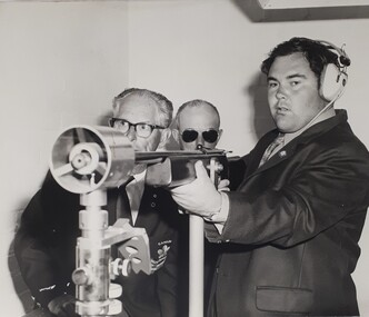 Vision Australia
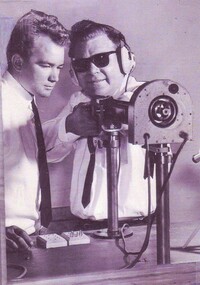
Photograph - Image, Man using rifle at competition, 1966-2003
An image taken of a man holding a rifle whilst two other men, one wearing a Canada Rifle Club blazer, look on. In the 1960's, the RVIB approached engineer George Glover to produce equipment to allow blind people to shoot, based upon that made available at St Dunstan's Hospital in the UK. The rifle range opened in February 1966 at the rear of St Kilda Road with 30 members, and soon became involved in matches with sighted rifle clubs in the area. The club had many successful years, competing against teams from Canada and New Zealand in 1968, and had the support of ICIANZ which provided them with free munitions as well as teams to compete against. In 1977, George Glover passed away and some of the skills required for maintenance of the equipment was lost, however the club continued until the late 1980's/early 1990s.1 Black and White image of man at shooting galleryrvib rifle club, royal victorian institute for the blind -
 Mont De Lancey
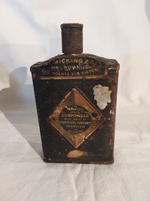
Container - Gunpowder Tin, Curtis's & Harvey Co
This fine grade gunpowder was used in pistols on farming properties. A vintage rusted black gunpowder tin with a screw top funnel lid. It has a diamond shaped indent on the front and centre back with black and white paper label branding of the manufacturer and supplier. The branding is on the top of the flask as well.'The Diamond Grain Gunpowder Made Only By Curtis's & Harvey Hounslow and London'. is printed on the diamond shaped paper label at the front. 'No. 2' is printed at the sides of this label. At the top of the tin is white text on a black background 'McMicking & Co. Melbourne Sole Agents for Victoria.' On the centre back of the tin is a printed paper illustration of dead rabbits and a rifle in the woods framed in a circle, surrounded by an etched diamond shape and 'Curtis's Harvey No.2'.containers, gunpowder, tins, firearm accessories, pistols, firearms, breechloading pistols -
 Tarnagulla History Archive
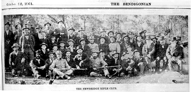
Photographs: The Newbridge Rifle Club (The Bendigonian), The Newbridge Rifle Club (The Bendigonian), October 22, 1901 (original)
The Newbridge Rifle Club Butts were behind a big hill north of road to Llanelly. Formed in 1900 for rifle practice during the Boer War. Range of 500 yards. Brigade Captain Bob Douglas. Murray Comrie Collection. Two copies of a monochrome photograph, image depicting a large group of men assembled in an outdoor setting, some holding firearms. Printed caption reads: 'The Newbridge Rifle Club' Title printed on top of page reads 'The Bendigonian' and 'October (?) 22 1901'. This is a poor quality copy of an older original, possibly a news clipping. Copy probably made by Murray Comrie in the 1960s.Accompanying note identifies some subjects: Standing: 1. Will Hart (?) 2. _________ 3. John Brown 4. Donald Joyner 5. Geo. Daws 6. _______ 7. Nat Ramsay 8._______ 9.__________ 10. Alf Michael 11. Bod Hamilton 12. Jack Bruce 13. Vince Pola 14. Frank Bruce 15. Eli Summers 16. ____ 17. ____ 18. ______ 19. Bob Chamberlain 20. P. Rayner 21. Ted Skinner 22. Geo. Martin 23. Bill Michael. Sitting: 1. ______ 2.______ 3. ______ 4. Will Ramsay 5. Nat Hart 6. Bob Douglas (in uniform) 7. Jim Joyner 8. Steve Hatt 9. Bob McKenzie 10. Charlie Summers (in uniform) 11. William Bridge (in uniform) 12. Tom Michael (in uniform). (Not sure if this matches the photo very well. Note filed in M. Comrie research notes (general).)newbridge, sports, recreation, shooting, clubs, rifle club, military, boer war -
 Mont De Lancey
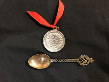
Medal and Spoon, 1904 and 1916
Silver medal awarded to Mr Thomas Quayle Jnr for Rifle shooting 1904. Silver spoon awarded to Mr Thomas Quayle for 400yds 1916. Mr. Thomas Quayle, son of Mr Thomas Quayle (pioneer) was manager of Rifle Range at Port Melbourne.Round Silver medal with red ribbon. Silver spoon Medal - "Won by T. Quayle Melbourne 1904" Spoon - "SYRC won by T. Quayle 400yds 1.11.16" -
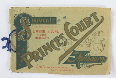 Wodonga & District Historical Society Inc
Booklet - Souvenir Booklet for Princes Court Amusement Park, Melbourne c. 1904-1905
Princes Court was an amusement park in Melbourne, located on St Kilda Road. Established in 1904, it closed its doors in 1909 after poor ticket sales due to Melbourne's temperamental weather. The park featured a toboggan ride and water chute ride where patrons inside open carriages were plunged down sloping structures from a height at great speeds. The park's other facilities and activities included a rifle range, a tug of war game, a Japanese tea house, a wine bar, a variety show, an open air cinema, and roller skating and bicycle races.This item contributes to our understanding of social life and recreation in early twentieth century Victoria. A souvenir booklet for Princes Court, an amusement park in Melbourne, printed for the years 1904-5. The booklet features photographs of the park's attractions, and advertisements for local businesses in Melbourne. wodonga, melbourne, princes park, amusement park, rides, fair, fairground, japanese tea house, st kilda -
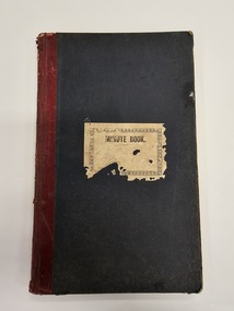 City of Kingston
Book - Minute book, Minute book of the Cheltenham Rifle Club, 1900
At a well attended meeting at the Mechanics Hall in Cheltenham in March 1900, attendees decided to form a rifle club. The newly appointed secretary of the newly formed Cheltenham Rifle Club, Mr E.C. Rippon, enrolled 55 new members on the day, and the club resolved to consult with the Defence Department regarding the suitability of Cheltenham Park for that purpose, and Moorabbin Council to grant the use of the park. By 1912 the club was already on the verge of disintegrating. The Cheltenham Park range had been disbanded two years earlier. A new, shorter range and club rooms were completed in October 1912. The club continued to have difficulties over location and funds, despite being granted an exemption from paying rates for the duration of the First World War. In 1919, a proposal to disband was put forward at a club meeting. Members rejected the proposal deciding instead to wait on the rumoured reopening of the Langwarrin range. By 1921 it became evident the Langwarrin range would not reopen. A resolution to wind up the organisation was put to the meeting and accepted.Green, cloth bound book with red leather spine. A white label is adhered to the front of the book with MINUTE BOOK printed in black text. The book is hardcovered and, inside, are approximately 186 pages which have been filled with handwritten text as meeting minutes and lists, including a list of commitee officers. The inside fly pages are decorated with blue and red marbling.Handwritten text on the white paper adhered to the front of the book is no longer legible.cheltenham, sport, club, rifles -
 Federation University Historical Collection
Map, Ballaarat Gold Field, 1861, 1861
A party of surveyors camped by Yuille's Swamp (later Lake Wendouree) and surveyed the countryside for a map to be produced by the Geological Survey of Victoria. In November 2004 the Central Highlands Regional Library presented a special edition of 200 copies of the 1861 map reproduced from a copy in their collection. Original 1861 map of Ballarat showing streets and leads. Blue dots indicate gold leads, and red lines indicate auriferous quartz reef and outcrops of quartz veins."Compiled & Drawn from the Survey of Mining Surveyors Davidson, Fitzpatrick and Cowan & the Plans in the Surveyor General's Office by J. Brahe, 21st October 1861. R. Brough Smyth, Secretary for Mines. The Honourable J.B. Humffray, M.L.A. Commr of Mines.”ballarat, map, ballarat east, lake wendouree, survey, mines, robert davidson, ballarat gold field 1861, yuille's swamp, wendouree swamp, little bendigo diggings, gold leads, old post office hill, specimen hill, bakery hill, black hill, dead horse creek, brown hill, pennyweight hill, clayton hill, soldiers hill, golden point, gum tree flat, white flat, poverty hill, chinese village, robert brough smyth, ballarat map 1861, ballaarat vineyard, dead horse gully, deadhorse creek, invermay, black hill flat, gaelic church, police reserve, magpie range, dalton's flat, caadian lead, rifle butts, powder magazine, bathing house, government camp, gold office, chinese, llanberrris, victoria theatre, charlie napier hotel, united states hotel, grape's hoel, clayton's hill, cattleyard hill, free trade hotel, esmond lead, bakery hill, black hill lead, juvenile reformatory, ballarat orphanage, lady barkly lead, triffet's slaughter yard, little bendigo, melbourne road, t. cowan, thomas cowan -
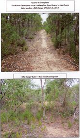 Stawell Historical Society Inc
Photograph, A Track into Grampians Quarry -- Previously a Railway Line & Rifle Range Taken 2017 -- 2 Photos -- Coloured
Two colour photographs of Track into Quarry Road Grampians. Once Rail Line used in construction of dam wall, later used as rifle range. The rifle range was once the last part of the railway track that ran to the quarry which was used to cart stone to Lake Fyans when it was being constructed. (1912-1918). The rifle butts are near to or part of the quarry. The Rifle range can still be seen. Two colour photographs of bush setting with track and dirt mound (rifle butts)stawell -
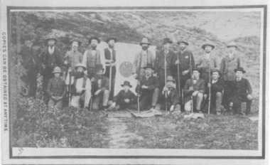 Bacchus Marsh & District Historical Society
Photograph, Bacchus Marsh Rifle Club members 1883
A Rifle Association was formed in Bacchus Marsh in April 1868. In 1882 this Association was reformed as the Bacchus Marsh Rifle Club and given the number 4. This photograph was taken at the first range used by the club which was near the old Woolpack Inn on the Melbourne to Ballarat Road. Rifle Club members in this image are known to include, W. H. McFarlane, F. Lewin, W. Marshall, T. Heath, E. A. Jones, W. Meikle, J. Dodemaide, D. Murray, W. H. McFarlane Jnr., J. Young, W. Mahoney, W, Rae. The Bacchus Marsh Express newspaper of 6 October 1883 reported that this image was taken during a married versus single match on the 3rd October, 1883. The match was interrupted to allow the photograph to be taken. This resulted in the match finishing in the dusk with the win going to the married team. This image is one of a series of photographs taken by Melbourne based photographers Stevenson and McNicoll who visited Bacchus Marsh and its nearby districts between September and November 1883. Black and white photographic print copy of original sepia 'carte de visite' style unframed photograph on card with gold border framing photograph. Part of the original inscription can be seen on the front left side of the photograph, which is one of a set of images taken in and around Bacchus Marsh in 1883 by the photographers Stevenson and McNicoll. The image shows a group of nineteen men holding rifles standing on either side of a white target board, the central bullseye showing a number of hits. All are posed against a backdrop of hills.Printed On the front: Stevenson & McNicoll. Photo. 108 Elizabeth St. Melbourne. COPIES CAN BE OBTAINED AT ANY TIME. stevenson and mcnicoll 1883 photographs of bacchus marsh and district, bacchus marsh rifle club, rifle clubs