Showing 730 items
matching ring road
-
 Greensborough Historical Society
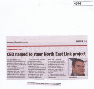
Newspaper Clipping, Diamond Valley Leader, CEO named to steer North East Link project, 01/03/2017
... metropolitan ring road...Greensborough Historical Society 34A Glenauburn Road Lower ...An engineer with decades of experience will be appointed chief executive of the new specialist North East Link Authority.News article 1 page, black text, colour image.north east link, metropolitan ring road, duncan elliott -
 Greensborough Historical Society
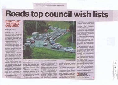
Newspaper Clipping, Diamond Valley Leader, Roads top council wish lists, 29/06/2016
... metropolitan ring road... council metropolitan ring road banyule city council News clipping ...Traffic issues in Banyule and surrounding areas are discussed.News clipping, black text and colour imagetraffic, north east link, banyule council, metropolitan ring road, banyule city council -
 Eltham District Historical Society Inc
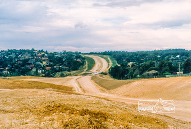
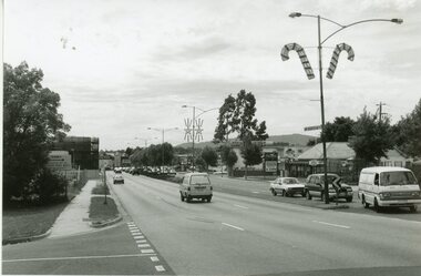
Photograph, Looking northeast across the new 5-span bridge construction across the Plenty River; Greensborough Bypass construction, c.1986, 1986c
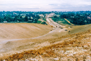
... northern ring road... northern ring road Colour photograph originally located ...Colour photograph originally located in a magnetic style album titled 'Greensborough Bypass 1990s 5' suffering significant degradation. No information contained in album or on reverse of photos except where noted. Relocated to archival photosafe storage.greensborough bypass, road construction, greensborough, northern ring road -
 Eltham District Historical Society Inc
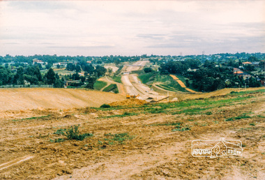
Photograph, Looking south towards Grimshaw Street, Greensbrorough; Greensborough Bypass construction, c.1986, 1986c
... northern ring road... northern ring road grimshaw street Colour photograph originally ...Colour photograph originally located in a magnetic style album titled 'Greensborough Bypass 1990s 5' suffering significant degradation. No information contained in album or on reverse of photos except where noted. Relocated to archival photosafe storage.greensborough bypass, road construction, greensborough, northern ring road, grimshaw street -
 Eltham District Historical Society Inc
Photograph, Looking south towards Grimshaw Street, Greensbrorough; Greensborough Bypass construction, c.1986, 1986c
... northern ring road... northern ring road grimshaw street Colour photograph originally ...Colour photograph originally located in a magnetic style album titled 'Greensborough Bypass 1990s 5' suffering significant degradation. No information contained in album or on reverse of photos except where noted. Relocated to archival photosafe storage.greensborough bypass, road construction, greensborough, northern ring road, grimshaw street -
 Greensborough Historical Society
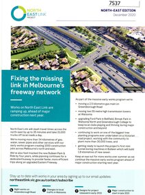
Pamphlet - Newsletter, Victorian Government, Fixing the missing link in Melbourne's freeway network, 2020_12
... western ring road... Edition December 2020 north east link western ring road Large ...An update on the North East Link Project, the North-East Edition December 2020 Large sheet folded twice. Colour illus. and map. 2 copies.north east link, western ring road -
 Greensborough Historical Society
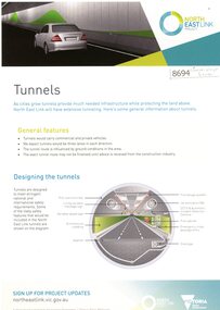
Newsletter - Leaflet, North East Link Authority, North East Link tunnels, and, Community Updates March 2022, 2022
... metropolitan ring road... updates north east link metropolitan ring road north east link ...The North East Link Authority was set up to lead development of this project. This newsletter, and additional leaflets, are to keep the community informed of project designs and developments in the area of underground tunnels.An ongoing collection of community updatesVarious page leaflets, colour text and images. Multiple updates on tunnels.north east link, metropolitan ring road, north east link tunnels -
 Greensborough Historical Society
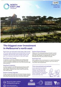
Leaflet, North East Link project update October 2021, 2021_10
... metropolitan ring road... metropolitan ring road north east link tunnels 1 sheet, 6 pages printed ...Updates on North East Link project.1 sheet, 6 pages printed in colour both sidesnorth east link, metropolitan ring road, north east link tunnels -
 Greensborough Historical Society
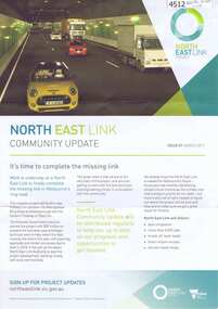
Newsletter - Leaflet, North East Link Authority, North East Link community update: Issue 01 March 2017, 2017
... metropolitan ring road... link metropolitan ring road north east link tunnels 4 page ...The North East Link Authority was set up to lead development of this project. The commencement of technical work has been approved by the State Government of Victoria. This newsletter, and additional leaflets, are to keep the community informed of project designs, developments and opportunities for consultation. An ongoing collection of community updates4 page leaflet, colour text and images; with further community updates on topics related to the projectnorth east link, metropolitan ring road, north east link tunnels -
 Ringwood and District Historical Society
Photograph, Ringwood black and white photographs
... site of Eastern Ring Road... bonview Ave near proposed site of Eastern Ring Road Black ...Black and white photographMaroondah Hwy. view East from bonview Ave near proposed site of Eastern Ring Road -
 Glenelg Shire Council Cultural Collection
Photograph - Photograph - Portland Harbour, n.d
... showing Henty Park, canal, railway line & freight wagons, ring..., canal, railway line & freight wagons, ring road. Photograph ...Port of Portland Authority Archivesport of portland archives, portland harbour -
Glenelg Shire Council Cultural Collection
Photograph - Photograph - Silo construction, n.d
... construction. Crane in centre of photo. Ring road, canal and part... Cliff Street Portland great-ocean-road Port of Portland ...Port of Portland Authority Archivesport of portland -
 Eltham District Historical Society Inc
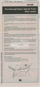
News Clipping, Advertisiing; Greensborough Bypass Upgrade Project Works Update, VicRoads, Diamond Valley Leader, 15 December 2004, 2004
... and extension of ring road connection... and extension of ring road connection Greensborough Bypass, Road ...Addition of second stage bridge over Plenty River and extension of ring road connectionNewsprintgreensborough bypass, road construction, vicroads -
Glenelg Shire Council Cultural Collection
Photograph - Photograph - Portland Bay, n.d
... going beneath Cape Nelson bridge. House on south side of ring... on south side of ring road, Portland on north side of Lagoon ...Port of Portland Authority ArchivesBack: - B.P & shed 5. in pencilport of portland archives, fawthrop lagoon -
 Greensborough Historical Society
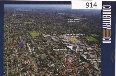
Photograph, Diamond Valley Leader, Greensborough: Aerial photograph, 21/05/2013
... with the Ring Road, Watermarc and Greensborough Plaza marked.... photographs of Greensborough with the Ring Road, Watermarc ...This advertisement for a property at 95 Alexandra Street Greensborough includes several aerial photographs of Greensborough with the Ring Road, Watermarc and Greensborough Plaza marked.An aerial view of Greensborough and surrounding areas in 2013.Colour advertisement including aerial photograph of Greensborough.alexandra street, greensborough plaza, watermarc -
![Work on paper - Newsletter, North East Link getting it right [June 2020], 2020_06](/media/collectors/4f729f5697f83e03086015b8/items/6014ef952bef110c704f3c4c/item-media/6014f0882bef110c704f42bf/item-fit-380x285.jpg) Greensborough Historical Society
Greensborough Historical SocietyWork on paper - Newsletter, North East Link getting it right [June 2020], 2020_06
... of developments. Includes a sketch map from the M80 Ring Road to Lower... the M80 Ring Road to Lower Plenty Road. north east link banyule ...Banyule City Council comments on the North East Link project. This newsletter is to keep the community informed of developments. Includes a sketch map from the M80 Ring Road to Lower Plenty Road.2 page leaflet, colour text and images.north east link, banyule city council, watsonia -
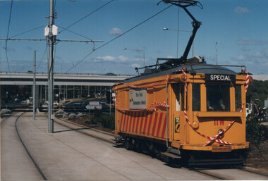 Melbourne Tram Museum
Photograph - Scrubber 11 W on Bundoora line, Ray Marsh, 29-9-1998
... after passing under the Western Ring Road overpass. Tram... passing under the Western Ring Road overpass. Tram is a former ...Colour print of Scrubber tram 11W in Plenty Road Bundoora after passing under the Western Ring Road overpass. Tram is a former Sydney scrubber tram and is now located at the Sydney Tramway Museum.Yields information about scrubber tram 11WColour print on Kodak Royal paper, with price lable and details hand written on rear along with the stamp of "Railway Tramway Photography"."11 W Bundoora 29-8-1998" and source stamp on rear.tramways, trams, scrubber 11w, tram 11w, plenty road, bundoora -
 Greensborough Historical Society
Map, Melbourne and Metropolitan Board of Works. Survey Division, MMBW, Yarra 2500 / 11.22. Bundoora, 1979_01
... ) and "proposed future freeway" (now Metropolitan Ring Road)... Brothers) and "proposed future freeway" (now Metropolitan Ring Road ...Melbourne and Metropolitan Board of Works. Yarra 2500 [base map] 11-22. Bundoora. Parish of Keelbundoora 2856, Municipalities of Diamond Valley 257 and Whittlesea 239. Prominent streets include: Greenhills Road, Cabernet Crescent and Plenty Road. Includes Parade College (Christian Brothers) and "proposed future freeway" (now Metropolitan Ring Road)MMBW Map in 1:2500 [scale] series. Cream parchment with green tape reinforcing on edges and punched holes on left edge.mmbw, melbourne and metropolitan board of works, shire of diamond valley, bundoora - maps -
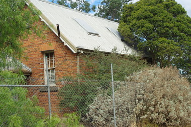
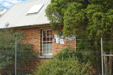
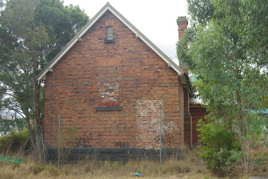
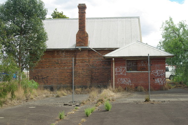
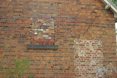
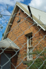
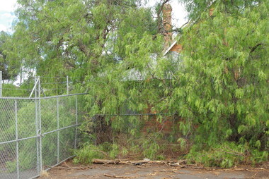 Greensborough Historical Society
Photograph - Digital Image, Bundoora Primary School Bu1915 (old building) 1, 18/03/2014
... Road and the Metropolitan Ring Road. The School has a Victorian... of Plenty Road and the Metropolitan Ring Road. The School has ...Bundoora Primary School No.1915 was constructed in 1877 of brick on a bluestone base with an iron roof and small porch. The school consisted of a single room with the dimensions 30 feet by 18 feet. It was a small rural school and in use for over 100 years. Today it sits abandoned at the intersection of Plenty Road and the Metropolitan Ring Road. The School has a Victorian Heritage Overlay (no H062) Photograph by Marilyn Smith 2014. Update: The old building has been incorporated into a childcare facility.Digital copy of colour photograph. bundoora primary school, bundoora state school -
 Greensborough Historical Society
Photograph - Digital Image, Bundoora Primary School Bu1915 (old building) 2, 18/03/2014
... Road and the Metropolitan Ring Road. The School has a Victorian... of Plenty Road and the Metropolitan Ring Road. The School has ...Bundoora Primary School No.1915 was constructed in 1877 of brick on a bluestone base with an iron roof and small porch. The school consisted of a single room with the dimensions 30 feet by 18 feet. It was a small rural school and in use for over 100 years. Today it sits abandoned at the intersection of Plenty Road and the Metropolitan Ring Road. The School has a Victorian Heritage Overlay (no H062) Photograph by Marilyn Smith 2014. Update: The old building has been incorporated into a childcare facility.Digital copy of colour photograph. bundoora primary school, bundoora state school -
 Greensborough Historical Society
Photograph - Digital Image, Bundoora Primary School Bu1915 (old building) 3, 18/03/2014
... Road and the Metropolitan Ring Road. The School has a Victorian... of Plenty Road and the Metropolitan Ring Road. The School has ...Bundoora Primary School No.1915 was constructed in 1877 of brick on a bluestone base with an iron roof and small porch. The school consisted of a single room with the dimensions 30 feet by 18 feet. It was a small rural school and in use for over 100 years. Today it sits abandoned at the intersection of Plenty Road and the Metropolitan Ring Road. The School has a Victorian Heritage Overlay (no H062) Photograph by Marilyn Smith 2014. Update: The old building has been incorporated into a childcare facility.Digital copy of colour photograph. bundoora primary school, bundoora state school -
 Greensborough Historical Society
Photograph - Digital Image, Bundoora Primary School Bu1915 (old building) 4, 18/03/2014
... Road and the Metropolitan Ring Road. The School has a Victorian... of Plenty Road and the Metropolitan Ring Road. The School has ...Bundoora Primary School No.1915 was constructed in 1877 of brick on a bluestone base with an iron roof and small porch. The school consisted of a single room with the dimensions 30 feet by 18 feet. It was a small rural school and in use for over 100 years. Today it sits abandoned at the intersection of Plenty Road and the Metropolitan Ring Road. The School has a Victorian Heritage Overlay (no H062) Photograph by Marilyn Smith 2014. Update: The old building has been incorporated into a childcare facility.Digital copy of colour photograph. bundoora primary school, bundoora state school -
 Greensborough Historical Society
Photograph - Digital Image, Bundoora Primary School Bu1915 (old building) 5, 18/03/2014
... Road and the Metropolitan Ring Road. The School has a Victorian... of Plenty Road and the Metropolitan Ring Road. The School has ...Bundoora Primary School No.1915 was constructed in 1877 of brick on a bluestone base with an iron roof and small porch. The school consisted of a single room with the dimensions 30 feet by 18 feet. It was a small rural school and in use for over 100 years. Today it sits abandoned at the intersection of Plenty Road and the Metropolitan Ring Road. The School has a Victorian Heritage Overlay (no H062) Photograph by Marilyn Smith 2014. Update: The old building has been incorporated into a childcare facility.Digital copy of colour photograph. bundoora primary school, bundoora state school -
 Greensborough Historical Society
Photograph - Digital Image, Bundoora Primary School Bu1915 (old building) 6, 18/03/2014
... Road and the Metropolitan Ring Road. The School has a Victorian... of Plenty Road and the Metropolitan Ring Road. The School has ...Bundoora Primary School No.1915 was constructed in 1877 of brick on a bluestone base with an iron roof and small porch. The school consisted of a single room with the dimensions 30 feet by 18 feet. It was a small rural school and in use for over 100 years. Today it sits abandoned at the intersection of Plenty Road and the Metropolitan Ring Road. The School has a Victorian Heritage Overlay (no H062) Photograph by Marilyn Smith 2014. Update: The old building has been incorporated into a childcare facility.Digital copy of colour photograph. bundoora primary school, bundoora state school -
 Greensborough Historical Society
Photograph - Digital Image, Bundoora Primary School Bu1915 (old building) 7, 18/03/2014
... Road and the Metropolitan Ring Road. The School has a Victorian... of Plenty Road and the Metropolitan Ring Road. The School has ...Bundoora Primary School No.1915 was constructed in 1877 of brick on a bluestone base with an iron roof and small porch. The school consisted of a single room with the dimensions 30 feet by 18 feet. It was a small rural school and in use for over 100 years. Today it sits abandoned at the intersection of Plenty Road and the Metropolitan Ring Road. The School has a Victorian Heritage Overlay (no H062) Photograph by Marilyn Smith 2014. Update: The old building has been incorporated into a childcare facility.Digital copy of colour photograph. bundoora primary school, bundoora state school -
 Greensborough Historical Society
Map, Melbourne and Metropolitan Board of Works. Survey Division, MMBW, Yarra 2500 / 12.22. Watsonia North, 1978_03
... Metropolitan Ring Road).... and "proposed future freeway" (now Metropolitan Ring Road). mmbw ...Melbourne and Metropolitan Board of Works. Yarra 2500 [base map]. 12-22, Parishes of Keelbundora 2856, Municipalities of Whittlesea 239 and Diamond Valley 257. Shows street names, easement sizes, lot numbers, lodged plan numbers, names of prominent features, contour values, creek or river names. Watsonia Railway Station and environs. Prominent streets: Edmund Rice Parade and Macorna Street. Includes Christian Brothers Edmund Rice College and Janefield Special School sites and "proposed future freeway" (now Metropolitan Ring Road).MMBW Map in 1:2500 [scale] series. Cream parchment with green tape reinforcing on edges and punched holes on left edge.mmbw, melbourne and metropolitan board of works, shire of diamond valley, watsonia - maps, bundoora - maps -
 Federation University Historical Collection
Booklet, Ballarat School of Mines, The School of Mines and Industries Ballarat, 1990
... ); Agriculture Training Centre at the Ballarat Common, Ring Road; Davey... at the Ballarat Common, Ring Road; Davey Street (Carpentry and Joinery ...The Ballarat School of Mines was established in 1870 through initiatives of the Ballarat Mining Board which felt there was a need for such an institution because of the declining number of mine managers for the goldfields. In c1990 campuses of the Ballarat School of Mines were: Barkly Street (Business and Computer Studies, Hairdressing and Horticulture apprenticeships); Agriculture Training Centre at the Ballarat Common, Ring Road; Davey Street (Carpentry and Joinery); Ararat Campus (Business Studies, Electronics, Welding, short courses); Lake Bolac TAFE Centre (Woolclassing, Post-Primary Service Programs); Ararat Prison (Basic Education and Training Programs) Howitt Street (Bricklaying); Ballarat Airport (Motorcycle Rider Training Facility.13 page soft covered promotional book covering the Ballarat School of Mines. The book includes an historical overview, timeline, Inskill, enrolment profile, student support, E.J. T. Tippett Library, Amenities Building, L.F.J. Hillman Recreaton Centre, Hillman, Tippett. There are numerous black and white images.ballarat school of mines, ballarat mining board, peter shiells, shiells, morgan john, john cain, timeline, inskill, small business centre, leoda atkinson, m.b. john -
Canterbury History Group
Photograph - Rachael Tracy outside her shop, No. 90 Maling Road, Jan Pigot, 27/03/1993 12:00:00 AM
... outside her shop, No. 90 Maling Road called Ring of Roses...., No. 90 Maling Road called Ring of Roses. Photograph Rachael Tracy ...Coloured photograph of Rachael Tracy arranging flowers outside her shop, No. 90 Maling Road called Ring of Roses.canterbury, maling road, shops, tracy family -
 Melbourne Tram Museum
Slide - Set of 7, Keith Caldwell, 10/03/1960 12:00:00 AM
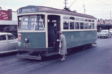
... . This store was later demolished for the Ring Road. Tram has adverts.... This store was later demolished for the Ring Road. Tram has adverts ...Set of 7 Agfa Colour slide, cardboard mount, by Keith Caldwell of 10 March 1960 - .1 - X2 677 - at the Williamstown Road terminus of the Footscray tram system. Tram photographed in Somerville Road, showing the return destination of Russell St. In the background are a row of shops. .2 - X1 460 turning from Leeds St into Barkly St. Tram has the destination of Ballarat Road. In the background is the bus stop and tram stop and the Trocadero Theatre side wall. See Image i6 for the Theatre. Has a Gant Motors advert. .3 - X1 467 out bound turning into Nicholson St from Irving St. Footscray with the Rockmans Store in the background. This store was later demolished for the Ring Road. Tram has adverts for Gant Motors and Swing Bridge Motors - Holdens. .4 - X1 460 turning from Barkly St into Leeds St, showing the destination of Ballarat Road. Has adverts for Calders watches and Coca Cola - drive safely. In the background is a cafe advertising Oysters, Grey Cigarettes and Vincents Powders. .5 - X1 464 turnings from Nicholson St into Irving St. Footscray with the Rockmans Store in the background. This store was later demolished for the Ring Road. Also is J. Boltons Chemist shop advertising Kodak film and another shop - ? dry cleaners, Footscray Fish Shop and Kings Hotel. Tram has adverts for Gant Motors and Doods Dry cleaning. There is a PMG truck parked outside Rockmans. .6 - X2 677 turning from Barkly St into Leeds St with the Trocadero Theatre in the background. Tram has the destination of Williamstown Road. Tram has an advert for Bridge and Webster. .7 - X1 467 outbound to Williamstown Road, turning from Leeds St into Irving St Footscray. Tram has adverts for Doods dry cleaning and Gant Motors.All hand stamped "10 Mar '60". .1 - marked "Footscray" .2 - "Footscray (NB curves)" .3 - to .7 "Footscray"trams, tramways, footscray, x2 class, russell st, williamstown rd, leeds st, ballarat rd, barkly st, nicholson st, irving st, tram 677, tram 460, tram 467, tram 464 -
 Melbourne Tram Museum
Newspaper, Leader Northcote, Melbourne Herald, " Campaign for Bourke St trams", " Those Trams" and "One way ahead", 1980 - 1981
... way, a ring road and traffic flows. Noted the "MMTB... way, a ring road and traffic flows. Noted the "MMTB ...Series of five news paper cuttings regarding tram operation in the CBD and in particular along Bourke St. Each cutting has the Aust. Press Cuttings Agency source sheet pasted to the top left hand corner along with the paper name and date stamp. .1 - Leader Northcote - 22/7/1981 - " Campaign for Bourke St trams", written by Ian Munro, regarding a proposal by the City Commissioners to remove trams from Bourke St and run via Lonsdale St. .2 - Melbourne Herald - 18/8/1981 - "Those Trams", editorial regarding the possibility of removing trams from Bourke St. .3 - as for .2, but a short piece - just the last paragraph of .2 .4 - Melbourne Herald - 10/9/1981 - editorial titled "One way ahead" about the possibility of a converting some city streets to one way, a ring road and traffic flows. Noted the "MMTB juggernauts". .5 - Melbourne Herald - 8/11/1980" - titled "Shut half of streets - expert" reporting that an American design consultant - Desmond Muirhead - about shutting streets to traffic, keeping trams as in the Bourke St Mall - uses Munich as an example.Some have In pencil "Ballarat Trams" in top left hand corner.trams, tramways, bourke st, lonsdale st, city of melbourne, mmtb, traffic control