Showing 2478 items
matching river street
-
 Greensborough Historical Society
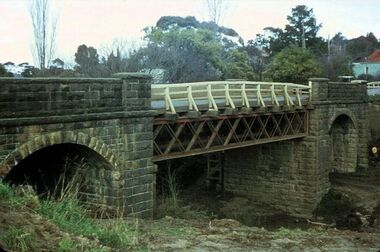
Photograph - Photograph - Digital Image, Bluestone bridge Greensborough 1960s, 1960s
... bridge greensborough plenty river greensborough main street ...A photograph of the bluestone bridge over the Plenty River at Greensborough 1960s.Digital copy of colour photograph. Second photo is cropped copy.bluestone bridge greensborough, plenty river greensborough, main street greensborough -
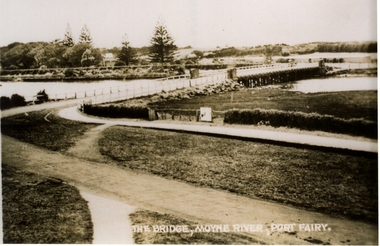
 Port Fairy Historical Society Museum and Archives
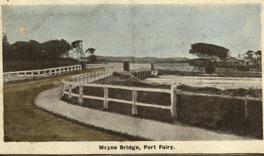
Photograph - Postcard, Moyne bridge
... Street Port Fairy great-ocean-road moyne bridge 1910 moyne river ...Photograph hand tinted of the Moyne river road bridge taken from Gipps Street showing house on the far bank on the right side taken for use as a PostcardMoyne Bridgemoyne bridge 1910, moyne river, traffic, gipps street -
 Port Fairy Historical Society Museum and Archives
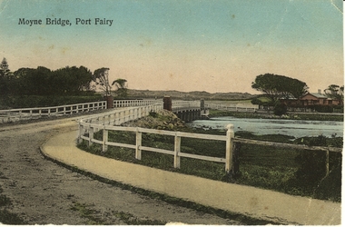
Photograph - Postcard, Moyne Bridge, Port Fairy
... Street Port Fairy great-ocean-road moyne bridge 1910 river road ...Hand tinted photograph of Moyne river road bridge taken looking East showing house on Griffith street on the right side in the background taken for use as a PostcardMoyne River, Port Fairymoyne bridge, 1910, river, road, gipps street -
 Port Fairy Historical Society Museum and Archives
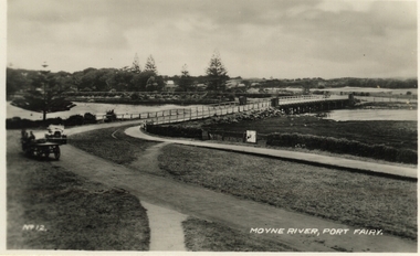
Postcard, Moyne River, Port Fairy
... car river road gipps street No 12 - Moyne River, Port Fairy ...Postcard made for tourists visiting port FairyBlack and white photograph of the road bridge crossing the river Moyne No 12 - Moyne River, Port Fairymoyne bridge, postcard, botanical gardens, cart, car, river, road, gipps street -
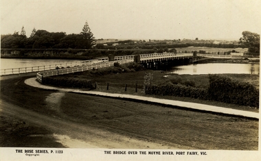 Port Fairy Historical Society Museum and Archives
Postcard, The Rose Series / The Rose Stereographs, The Bridge over Moyne River, Port Fairy Vic
... gipps street river dunes botanical gardens The Rose Series P ...Black and white Photograph of the Moyne river road bridge with the botanical gardens in the left background and some huts built possibly on Hughes AvenueThe Rose Series P.1123 copyright.- The Bridge over the Moyne River Port Fairy Vic.moyne bridge, hughes avenue, gipps street, river, dunes, botanical gardens -
 Port Fairy Historical Society Museum and Archives
Photograph
... Street Port Fairy great-ocean-road Moyne river bridge photograph ...Moyne river bridge photograph taken in 1956 showing Blakes caravan park in backgroundColoured landscape of the Moyne River bridge taken from the balcony of the house (Riverside) on the corner of Regent Street and Gipps street From Tom Bartlett's Gipps Street looking East over bridge 1956bridge, moyne river, traffic, gipps street -
 Tatura Irrigation & Wartime Camps Museum
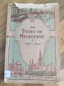
Book, The Story of Melbourne, 1934
... discovery scene and Yarra river, Flinders Street, Station and St... and Yarra river, Flinders Street, Station and St. Paul's Cathedral ...Cream, pale green cover. Brown lettering. Sketches of early discovery scene and Yarra river, Flinders Street, Station and St. Paul's Cathedralthe story of melbourne, kenyon af, stewart f, tatura, victorian history, sir gengoult-smith -
 Ballarat Heritage Services
Photograph, Clare Gervasoni, Yarrowee Channel Near Hill Street, Ballarat, 27/06/2021
... River near Hill Street and Redan. Ut shows were the channel... and unchanneled Yarrowee River near Hill Street and Redan. Ut shows were ...Photographs of the channelled and unchanneled Yarrowee River near Hill Street and Redan. Ut shows were the channel ends.yarrowee river, yarrowee creek, yarrowee channnel, bluestone channel, bluestone -
 Port Fairy Historical Society Museum and Archives
Postcard, Valentine Publishing Co, The Bridge Moyne River Pt Fairy, 10.04.1929
... river with Gipps street in the foreground cleared land... Street Port Fairy great-ocean-road moyne bridge circa 1930 bridge ...Black and white Photograph of the bridge crossing the Moyne river with Gipps street in the foreground cleared land in the background taken for use as a postcardThe Bridge Moyne River Pt Fairymoyne bridge circa 1930, bridge, moyne river, river, road -
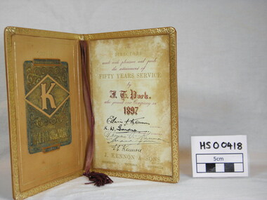 Richmond & Burnley Historical Society
Service Award, J. Kennon & Sons Pty Ltd, Kennon Tannery 50 Year Service Award to J.T.Park, c. 1897
... of Service, 1897 -1947 J. Kennon & Sons Tannery, River Street... & Sons Tannery, River Street, Richmond. The/Directors/mark ...The Certificate was presented to the Society by J T Parks daughter after a presentation by John rose who spoke about the history of the Kennon Family and the Kennon Tannery.Limited number of certificates issued with 50 years of Service. The Certificate is representative of companies in Richmond and the extended loyalty and service of employees.Guilded Leather Certificate, Tan colour. Cover Engraving - J T Park Certificate No. 4 Years of Service, 1897 -1947 J. Kennon & Sons Tannery, River Street, Richmond. The/Directors/mark with pleasure and pride/the attainment of/Fifty Years Service/by/J.T.Parks/who joined our company in/1897/signed by the Chairman and Directors/ Edwin J. Kennon/K.W.Gardner/Thomas A. Kennon/E.C.Kennon/ J.Kennon & Sons Pty Ltd/ Richmond Victoria Australia service, award, kennon, tannery, j t parks, richmond -
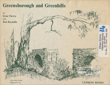 Eltham District Historical Society Inc
Book, Irene Turvey et al, Greensborough and Greenhills / words by Irene Turvey ; Drawings by Ron Reynolds, 1973
... Station), Partington's Flat and River Valley, Rand Street Bridge... Station), Partington's Flat and River Valley, Rand Street Bridge ...Pen and ink sketches accompanied by appropriate text in double page spreads. Contents cover : Blue stone bridge, Introduction, House cnr Church and Hailes Street, House - 25 Hailes Street, Yandell Reserve, Greensborough Hotel, Lobb's Kiosk, House - 49 Grimshaw Street, View of Greensborough (from Delphin Crescent), Railway Station, Old Barn (near Greensborough Railway Station), Partington's Flat and River Valley, Rand Street Bridge, Lower Main Street, Greenbriar Nursery, Hitching rail, Ashmead - Dr Cordner's Home, Greensborough Primary School, House - cnr St Helena and Diamond Creek Raods, Sondermeyer's Hill, Methodist Church, Football Pavilion, Cemetery, St Katherine's Church, St. Helena, Civic Centre, Briar Hill Timber Mill, 24 River Street, Kelly's Garden Supplies, 158 Main Street, Old Swimming pool, 105 Main Street.Hardback; 62 p. : ill., map ; 19 x 25 cm.ISBN 0909807108 Signed by author and illustrator Two copiesgreenhills, greensborough -
 Greensborough Historical Society
Photograph - Photograph - Digital Image, Marilyn Smith, Greensborough trees 2020, 24/08/2020
... , This image shows the trimmed trees near the Plenty River and Main..., This image shows the trimmed trees near the Plenty River and Main ...Digital image of trees at Greensborough 24/08/2020, This image shows the trimmed trees near the Plenty River and Main Street GreensboroughPart of a collection of miscellaneous historical images with a connection to the local area.Digital colour photograph. plenty river, trees - greensborough -
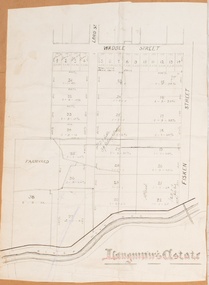 Bacchus Marsh & District Historical Society
Map, Langmann's Estate Bacchus Marsh
... . The area is bounded by the Werribee River, Fisken Street, Waddle... is bounded by the Werribee River, Fisken Street, Waddle Street(sic ...The date of this map has not been determined. It bears the signature of D.A. Little upon of a portion of the map. Little was Bacchus Marsh Shire Secretary and Engineer between 1886 and 1914 which dates the map to some time between 1886 and 1914.A single page paper map showing a portions of land in part of Bacchus Marsh.The area shown is described as Langmann's Estate. The area is bounded by the Werribee River, Fisken Street, Waddle Street(sic.) (Waddell) and Lord Street. The map is pasted into a bound volume containing 76 maps or plans in total. High resolution digital image stored on BMDHS computer network. interim map record stage 1, bacchus marsh victoria maps -
 Bacchus Marsh & District Historical Society
Map, Maddingley Township, Parish of Parwan, 1880s
... A single page paper map showing land allotments, streets... A single page paper map showing land allotments, streets, rivers ...This map is dated Sept. 6th 1856. However places in the township of Maddingley which did not appear until the late 1880s such as the Bacchus Marsh Railway Station and line are shown on this map in their correct locations. This suggests the map has been derived from an earlier map. An earlier date of 1843 with a surveyor's name preceding it can also be seen on the map. The map is important because it indicates the location and dimensions of early but now discontinued use of land such as the showgrounds and police paddock and a site reserved for the Church of England which was not ultimately used for a permanent church. A single page paper map showing land allotments, streets, rivers, creeks, park lands, the railway line and Bacchus Marsh railway station in the township of Maddingley. The map is pasted into a bound volume containing 76 maps or plans in total. Bottom of Map: Surveyor-General's Office, Melbourne, Sept 6th, 1856bacchus marsh victoria maps, maddingley victoria maps, land use, maddingley victoria history -
 Bacchus Marsh & District Historical Society
Map, Maddingley Township, Parish of Parwan, circa 1890s
... A single page paper map showing land allotments, streets... showing land allotments, streets, rivers, creeks, park lands ...Maddingley is a locality or township within the broader township area of Bacchus Marsh. This map is not dated. However features in Maddingley which appeared in the 1880s and 1890s are present in the map, These include the Bacchus Marsh Railway Station and the Bacchus Marsh Showgrounds. The main residential and commercial area of Maddingley is shown on this map in an area bounded by Bacchus Street, Barry Street, Griffith Street and Maddingley Road. Other streets visible are Franklin Street, Inglis Street, Labilliere Street, McCrae Street, Moore Street and part of Station Street.A single page paper map showing land allotments, streets, rivers, creeks, park lands, the railway line and Bacchus Marsh railway station in the township of Maddingley. The map is pasted into a bound volume containing 76 maps or plans in total. bacchus marsh victoria maps, maddingley victoria maps, land use, maddingley victoria history -
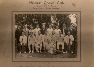 Greensborough Historical Society
Photograph (copy), Hillcrest Cricket Club: photograph and article, 1931-1932
... Cricket Club was situated between Mountainview Road and … Street... flat more or less where River Street met Mountainview Road ...The Hillcrest Cricket Club is shown in the 1931-32 season. The photograph is named. The photo is accompanied by a handwritten short history of the club by Ray Hooper: "Hillcrest C.C.- Hillcrest Cricket Club was situated between Mountainview Road and … Street at the top of the hill. Where it became flat more or less where River Street met Mountainview Road (straight up). The land was owned by Mr J Ellis (senior) who allowed the local men to make a cricket pitch so they could form a cricket team and enter in the Eltham District Cricket Association (1925-1930). As you can see Mr Ellis Senior (by photo) became president and both his sons played for Hillcrest C.C. My father also played and I can just remember W Mills (Captain), H.Padget, H.Johnson, J.Parks and H.Weidlich (as I got older). Ray Hooper." Copy of group photograph and handwritten article.Group photograph is named.hillcrest cricket club, ray hooper -
 Port Fairy Historical Society Museum and Archives
Photograph, Alex Wilkins, c1940's
... showing Cox Street, William Street,Lower half of Bank Street River...,Lower half of Bank Street River and sea. The Gas works ...This photograph depicts Port Fairy streets in the 1940's showing Cox Street, William Street,Lower half of Bank Street River and sea. The Gas works are visible on Cox StreetThis photograph taken in the 1940's is significant because of the detail of that is shows regarding the set out of the streets and the vacant landblack and white photograph of the streets of Port Fairy2 stamps - ALEX WILKINS Photographer Warrnambool, Mrs O.G. Powell Phone 883 Port Fairy.( No 6 set over Sect 4) 4-6 streets, moyne river, port fairy, cox street, william street, gas works -
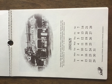 Yarrawonga and Mulwala Pioneer Museum
Calendar 1984, Yarrawonga over the Years, 1983
... for each month. Depicts early scenes of Yarrawonga Streets, river... of Yarrawonga Streets, river, hotels, stores, Showgrounds - all ...“Spiral bound A4 size 12 pages and front and back cover. Cream embossed heavy paper with sepia print. Contains one page for each month. Depicts early scenes of Yarrawonga Streets, river, hotels, stores, Showgrounds - all with descriptions See photos -
 Glenelg Shire Council Cultural Collection
Painting, George H.L Pentland, Casterton 1889, 1889
... the Glenelg River, the bridge, main street and rolling landscape... Cliff Street Portland great-ocean-road Casterton & District ...Casterton & District Historical Society Inc.Painting, oil on canvas showing a 'bird's-eye' view' of the township of Casterton in the late 19th century. It shows the Glenelg River, the bridge, main street and rolling landscape of the Western District.casterton, oil painting, landscape -
 Greensborough Historical Society
Map, Municipality of Heidelberg Plan No. 481, 23/9/1949
... Street, showing river and buildings in green and gradients in red..., South boundary Grimshaw Street, showing river and buildings ...Central area of Greensborough, South boundary Grimshaw Street, showing river and buildings in green and gradients in red. Adjoins Map No. 480 to West.Black & white map with features in red and green. Scale: 160 feet to 1 inch.greensborough, grimshaw street greensborough -
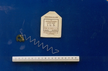 Royal Australian and New Zealand College of Obstetricians & Gynaecologists (RANZCOG)
Intrauterine device, Anderson-Ansell design, Ansell, 1970s
... and produced at the Ansell factory, 18 River Street, Richmond... and produced at the Ansell factory, 18 River Street, Richmond ...The only IUD of Australian origin, developed in 1971 by Australian doctor Ian Anderson in partnership with Ansell Australia and produced at the Ansell factory, 18 River Street, Richmond in the 1970s. The device was taken up by the Battelle Foundation, USA, and clinical trials were carried out in Israel, Indonesia and Singapore. No formal clinical trials were carried out in Australia. The device was used extensively by Population Services International, a private abortion clinic in Sydney in the mid 1970s. At the time this device was donated to the collection in 1997, there were legal proceedings regarding two Australian women who claimed ongoing problems as a result of its use. The donor, Dr Richard Gutch, practised in Clifton Hill and used some in the 1970s but not for long. The drawbacks were the multi-filament string acted as a wick for infection, also the latex leaf often came away from the thread when pulled for removal. Curettage was often the only effective way to remove the IUD. Dr Gutch removed many as he developed a reputation for being skilled at their removal.Intrauterine device (IUD), Ansell-Anderson latex leaf design, with paper sleeve. Made of latex impregnated with copper and zinc. The IUD is leaf-shaped with serrated edge and diamond shape cut out from its centre. Small hole in tail with attached twisted cream coloured thread. Paper sleeve is stamped, "THE/ ANDERSON-ANSELL/LATEX LEAF/I.U.D". SIZE:A/PATENTS PENDING", and notes it is Size A.contraceptive, intrauterine device -
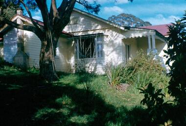
 Greensborough Historical Society
Photograph - Digital Image, Blackjack, 1954_
... orchards ran down to the Plenty River off Hume Street Greensborough..., house and acres of fruit orchards ran down to the Plenty River ...Blackjack. The Blackjack property, house and acres of fruit orchards ran down to the Plenty River off Hume Street Greensborough and was the home of the Robinson family to late 1956. The photographs were taken as slides by Frank Robinson and digitised by his son James in 2015.Digital copy of colour photograph.robinson family, blackjack -
 Greensborough Historical Society
Photograph - Digital Image, The grounds at Blackjack, 1956_
... orchards ran down to the Plenty River off Hume Street Greensborough... and acres of fruit orchards ran down to the Plenty River off Hume ...The grounds at Blackjack, the home of the Robinson family to late 1956. The Blackjack property, house and acres of fruit orchards ran down to the Plenty River off Hume Street Greensborough. The photographs were taken as slides by Frank Robinson and digitised by his son James in 2015.Digital copy of colour photograph.blackjack, robinson family -
 Kew Historical Society Inc
Photograph - Flooding of the Yarra River in North Kew, 1934
... river. Semi-submerged street lighting indicates that entire... in a rowboat in the middle of the flooded river. Semi-submerged street ...North Kew, now divided between Kew and Kew East, bordered the Yarra River. As such, it was a region subject to flooding in the Yarra Valley. Development beyond this point (ie Kellett Grove) was limited by the City of Kew's planning regulations. Prior to urban development, the area since European settlement and the first land sales in the district in the 1840s, had been used for dairy farming. Small sepia snapshot of floodwaters taken from near Willsmere Road, in what was then known as North Kew. The point of view is looking towards Fairfield. In the foreground are two figures viewing a group in a rowboat in the middle of the flooded river. Semi-submerged street lighting indicates that entire streets had been. overwhelmed by the flood waters. Verso: WILLSMERE ROAD NORTH KEW / Stamped 3 163yarra river -- north kew, floods -- yarra valley, floods -- north kew, floods -- 1934, natural disasters -- kew, willsmere road -
 Greensborough Historical Society
Photograph - Digital image, Frank Robinson, Greensborough wattles, 1954_
... , house and acres of fruit orchards ran down to the Plenty River... to the Plenty River off Hume Street Greensborough and was the home ...Greensborough wattles at Blackjack. The Blackjack property, house and acres of fruit orchards ran down to the Plenty River off Hume Street Greensborough and was the home of the Robinson family to late 1956. The photographs were taken as slides by Frank Robinson and digitised by his son James in 2015.Digital copy of colour photograph.robinson family -
 Greensborough Historical Society
Photograph - Digital Image, Blackjack - looking south east up the hill, 1954_
... , house and acres of fruit orchards ran down to the Plenty River... to the Plenty River off Hume Street Greensborough and was the home ...Greensborough wattles at Blackjack. The Blackjack property, house and acres of fruit orchards ran down to the Plenty River off Hume Street Greensborough and was the home of the Robinson family to late 1956. The photographs were taken as slides by Frank Robinson and digitised by his son James in 2015.Digital copy of colour photograph.robinson family, blackjack -
![Photograph - Digital image, Rand Street Bridge [Greensborough], 02/05/2013](/media/collectors/4f729f5697f83e03086015b8/items/572af0f12162f118342f250e/item-media/572af1252162f118342f2a1f/item-fit-380x285.jpg) Greensborough Historical Society
Greensborough Historical SocietyPhotograph - Digital image, Rand Street Bridge [Greensborough], 02/05/2013
... the Plenty River between Rand Street and Greensborough Station..... This is a pedestrian swing bridge over the Plenty River between Rand Street ...These photographs of the Rand Street Bridge were taken in 2013 to show changes over 40 years, based on Ron Reynold’s sketches in the 1973 publication “Greensborough and Greenhills” published by Cypress Books. This is a pedestrian swing bridge over the Plenty River between Rand Street and Greensborough Station.Digital copy of colour photograph.greensborough and greenhills, rand street bridge, rand street greensborough, ron reynolds -
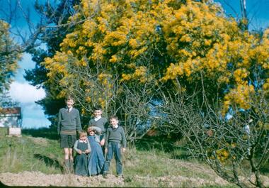 Greensborough Historical Society
Photograph - Digital Image, Blackjack: five boys in the garden, wattle flowering, 1953_
... and acres of fruit orchards ran down to the Plenty River off Hume... to the Plenty River off Hume Street Greensborough. The photographs were ...Five boys in the garden at Blackjack, the home of the Robinson family to late 1956. The Blackjack property, house and acres of fruit orchards ran down to the Plenty River off Hume Street Greensborough. The photographs were taken as slides by Frank Robinson and digitised by his son James in 2015.Digital copy of colour photograph.blackjack, hume street greensborough, robinson family, frank robinson -
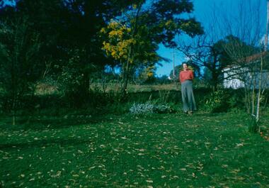 Greensborough Historical Society
Photograph - Digital Image, Blackjack: Beb standing in the garden, 1953_
... and acres of fruit orchards ran down to the Plenty River off Hume... to the Plenty River off Hume Street Greensborough. The photographs were ...Beb standing in the garden at Blackjack, the home of the Robinson family to late 1956. The Blackjack property, house and acres of fruit orchards ran down to the Plenty River off Hume Street Greensborough. The photographs were taken as slides by Frank Robinson and digitised by his son James in 2015.Digital copy of colour photograph.robinson family, blackjack, hume street greensborough -
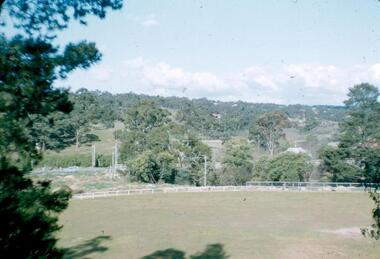 Greensborough Historical Society
Photograph - Digital image, Frank Robinson, Greensborough Football Ground, 1956_
... River off Hume Street Greensborough and was the home... ran down to the Plenty River off Hume Street Greensborough ...The Greensborough football ground 1956. The Blackjack property, house and acres of fruit orchards ran down to the Plenty River off Hume Street Greensborough and was the home of the Robinson family to late 1956. The photographs were taken as slides by Frank Robinson and digitised by his son James in 2015.Digital copy of colour photograph.frank robinson, greensborough football club