Showing 5684 items
matching road named
-
 Whitehorse Historical Society Inc.
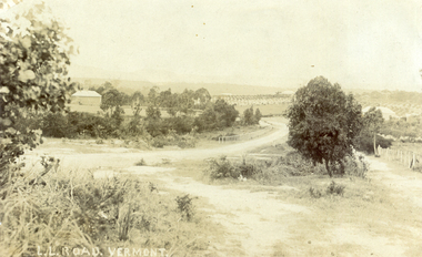
Photograph, L L Road Vermont, late 1800
... after which the road was named. Name was changed to Boronia Road... was known as L L Vale after which the road was named. Name ...Dr L L Smith was a pioneer of the Vermont District. He owned 250 acres in the area bounded by Boronia, Canterbury and Heatherdale Roads and the creek. The property was known as L L Vale after which the road was named. Name was changed to Boronia Road in later years. He was a Doctor with rooms in the City, was a member of Parliament.Sepia Postcard of L L Road, Vermont (now Boronia Road) taken in the early 1900s (card is postmarked 27 Aug 1909). Shows the road going down it is presumed to the creek. It is possible that the house is that of Dr.L.L.Smith. See History.|Orchard in background is the Finger orchard. (from Mr. Shambrook - Tim's father)|Information on the back of the Postcard reveal it was sent to Miss Roberts of 61 Hoddle Street Richmond Victoria by Muriel at 37 Victoria Road Northcote and was posted at the Fairfield Post Office Victoria on 27 August 1909. Text is 'Dear Ethel Just a Post Card to let you know I will be out to see you on Monday if convenient. I came down with Mr Hutchinson and he asked me what were we laughing out on the Sunday when he came up. Muriel|See the following references -ND199, 313, 539. 1242, 2013, 3680 & 4295.l l road vermont, boronia road vermont, smith . l l dr -
 Whitehorse Historical Society Inc.
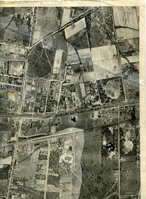
Map, Photo-map Ringwood A4A, 1945
... (North to south). Names of main roads inscribed.... to Hawthorn Road (North to south). Names of main roads inscribed ...Aerial photo covering approximately from Box Hill to Mitcham (West to East) and Springfield Road to Hawthorn Road (North to south).Aerial photo covering approximately from Box Hill to Mitcham (West to East) and Springfield Road to Hawthorn Road (North to south). Names of main roads inscribed.Aerial photo covering approximately from Box Hill to Mitcham (West to East) and Springfield Road to Hawthorn Road (North to south).aerial photographs, box hill, blackburn, nunawading, forest hill, mitcham -
 Melbourne Legacy
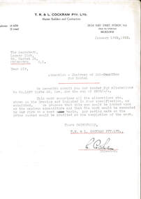
Letter, Alterations to 1267 Burke Road
... Club submitting their tender for alterations to 1267 Burke Road... submitting their tender for alterations to 1267 Burke Road ...A letter dated 18 January 1943 from builders to the Legacy Club submitting their tender for alterations to 1267 Burke Road for the sum of £408. The property mentioned at 1267 Burke Road was named Holmbush and was the first hostel for children that Legacy started and operated from April 1943. It was later renamed Blamey House after another hostel called Blamey House was closed.A record of the tender process to make changes to Holmbush to become a residence for children.White quarto letterhead, black type, two hole punched, a letter about alterations to be made at Holmbush.Signed in ink by L. Cockram of T.R. and L. Cockram Pty Ltd, Master Builders and Contractorsresidences, renovations, holmbush -
 Whitehorse Historical Society Inc.
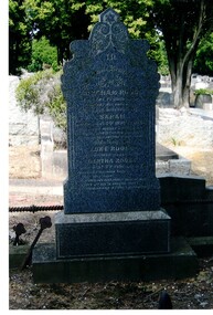
Photograph, Tombstone - Rooks family
... a school was attached to the chapel. Rooks Road is named after him..... In 1970 a school was attached to the chapel. Rooks Road is named ...The Rooks family emigrated from England in 1857. Abraham Rooks came to Forest Hill in 1862 and leased 79 acres. After 10 years of successful farming he owned the land. Abraham Rooks held the first church meetings in his home and in 1865 was one of the trustees to receive a crown grant to erect a chapel. In 1970 a school was attached to the chapel. Rooks Road is named after him.Coloured photo of the Rooks family tombstone - grave 226, Methodist section|Rooks, Abraham died 1 September 1889, aged 65 years|Rooks, Sarah died 2 January 1898, aged 66 yearsrooks, abraham, rooks, sarah, tombstones, rooks road, vermont -
 Whitehorse Historical Society Inc.
Map - Parish Map, Parish of Nunawading, 1892
... . The map includes roads, railway, stations, names of property.... The map includes roads, railway, stations, names of property ...A map copied from 'Directory maps - parishes and counties' dated 26 Nov 1892. Compiled and lithographed by G.S. Bonney. The map includes roads, railway, stations, names of property owners. It has a scale [ca. 1:31,680] 40 chains to an 1 inch.A map copied from 'Directory maps - parishes and counties' dated 26 Nov 1892. Compiled and lithographed by G.S. Bonney. The map includes roads, railway, stations, names of property owners. It has a scale [ca. 1:31,680] 40 chains to an 1 inch.non-fictionA map copied from 'Directory maps - parishes and counties' dated 26 Nov 1892. Compiled and lithographed by G.S. Bonney. The map includes roads, railway, stations, names of property owners. It has a scale [ca. 1:31,680] 40 chains to an 1 inch.maps, parish of nunawading -
 Kew Historical Society Inc
Archive (series) - Subject File, Adeney, William, 1971
... , of Clifton Villa, Cotham Road. Researcher name - John Adeney... of William Adeney, of Clifton Villa, Cotham Road. Researcher name ...Various PartiesReference, Research, InformationKHS OrderReference file containing items of correspondence from 1971 relating to a query regarding the life of William Adeney, of Clifton Villa, Cotham Road. Researcher name - John Adeney. Response from Mrs E. West, KHS Secretary. The file contains snippets of original research on Adeney (Rate Books - William Adeney, Park Street (later Adeney Avenue) 1878. The response refers to memories by Frances Dumaresq who knew the descendants.william adeney, adeney avenue - kew (vic.), clifton villa - cotham road - kew (vic.)william adeney, adeney avenue - kew (vic.), clifton villa - cotham road - kew (vic.) -
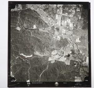 Bendigo Historical Society Inc.
Map - CAMPBELL COLLECTION: BENDIGO AND DISTRICT MAPS
... (part). Crusoe Reservoir bottom right corner on Crusoe Road... Lockwood and Crusoe Roads. Map Name : Bendigo Mapsheet Run 2. 14-2 ...Map. Two aerial photographs of Kangaroo Flat and Lockwood (part). Crusoe Reservoir bottom right corner on Crusoe Road, shows Merindah Road running between Lockwood and Crusoe Roads. Map Name : Bendigo Mapsheet Run 2. 14-2-71, 13,200 A.S.L.. Map shown with NORTH at bottom of page, VIC 2479 at corner. Map 2 continues to the west. A joined copy of both photographs is also included.map, bendigo, agricultural lands -
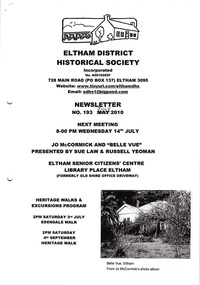 Eltham District Historical Society Inc
Newsletter, Newsletter, No. 193 July 2010
... • Edendale Walk • Local Road and Street Names by Russell Yeoman... • Edendale Walk • Local Road and Street Names by Russell Yeoman ...Contents: • Next meeting, guest speaker; Sue Law and Russell Yeoman: Jo McCormick and ‘Belle Vue’ • July Meeting • Edendale Walk • Local Road and Street Names by Russell Yeoman • The Christmas Hills Story • More News The Shire of Eltham Historical Society was formed in October 1967. The first newsletter of the Society was issued May 1978 and has been published continuously ever since on a bi-monthly basis. With the cessation of the Shire of Eltham in late 1994, the Society's name was revised to Eltham District Historical Society and this name first appeared with issue No. 103, July 1995. The collection of the Society's newsletters provides a valuable resource on the history of the Society's activities, office bearers and committee members, guest speakers and subjects of historical interest pertinent to the former Shire of Eltham and the Eltham District.A4 photocopied newsletter distributed to membersnewsletter, eltham district historical society, shire of eltham historical society -
 City of Whittlesea
Archive - Cr L P Mitchell Collection, Councillor Laurence Mitchell Collection
... . The Laurimar estate on Yan yean road Doreen is named after.... The Laurimar estate on Yan yean road Doreen is named after ...Cr L P Mitchell was a councillor with the Shire of Whittlesea from 1947 until the 1970s. He was Shire president in 1954. The Laurimar estate on Yan yean road Doreen is named after the Counillor and his wife - Laurence and Mary.4 components of this collection: compact, medal, dress and documentsCompact inscription: Presented to Mrs L P Mitchell from Debs 1955 Medal inscription: Royal Agricultural Society of Victoria. Not transferrable 1958. (member no) 1996 -
 Lakes Entrance Historical Society
Photograph - The 4 Mile Camp Old Buchan Road, Buchan Victoria, 1935-36
... Buchan Road East Gippsland Victoria. Names on second photo... in a bush setting at the Four Mile Old Buchan Road East Gippsland ...Black and white photograph of eight bush workers Charles Pettman with a dog posed in a bush setting at the Four Mile Old Buchan Road East Gippsland Victoria. Names on second photoworkmen, engineering, government services -
 Eltham District Historical Society Inc
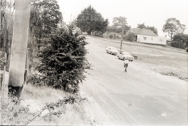
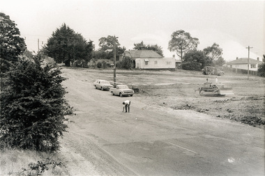
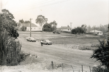
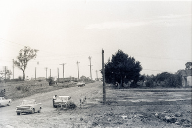
Photograph, Sherbourne Road, Para Road and Simms Road at Briar Hill/Montmorency prior to the upgrade of Sherbourne Road Railway bridge, c.1970
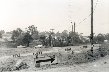
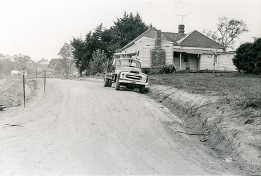
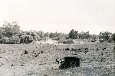
... time depicting Sherbourne Road, Para Road and Simms Road... time depicting Sherbourne Road, Para Road and Simms Road ...Collection of photographs probably taken around the same time depicting Sherbourne Road, Para Road and Simms Road at Briar Hill/Montmorency prior to the upgrade of Sherbourne Road Railway bridge, c.1970. Photo 01648_ 19 This home owned by Mrs Cameron. Her daughter married a Mr Davey, for whom Davey Road was named - email from M. Jones 20/07/2015 Photographer unknownThese photos are very significant in the documentation of the development of the Briar Hill and Montmorency areas and the changes in the physical landscape along the railway line area.20 black and white prints 9 cm x 13 cm.1970, briar hill, davey road, montmorency, para road, cameron, davey, sherbourne road, simms road, railway line, roadworks -
 Eltham District Historical Society Inc
Photograph, Sherbourne Road, Para Road and Simms Road at Briar Hill/Montmorency prior to the upgrade of Sherbourne Road Railway bridge, c.1970
... time depicting Sherbourne Road, Para Road and Simms Road... time depicting Sherbourne Road, Para Road and Simms Road ...Collection of photographs probably taken around the same time depicting Sherbourne Road, Para Road and Simms Road at Briar Hill/Montmorency prior to the upgrade of Sherbourne Road Railway bridge, c.1970. Photo 01648_ 19 This home owned by Mrs Cameron. Her daughter married a Mr Davey, for whom Davey Road was named - email from M. Jones 20/07/2015 Photographer unknownThese photos are very significant in the documentation of the development of the Briar Hill and Montmorency areas and the changes in the physical landscape along the railway line area.20 black and white prints 9 cm x 13 cm.1970, briar hill, davey road, montmorency, para road, cameron, davey, sherbourne road, simms road, railway line, roadworks -
 Surrey Hills Historical Society Collection
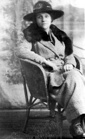
Photograph, Mary Sneddon
... at his father's home. They lived at 'Cliburn' 14 Suffolk Road... at 'Cliburn' 14 Suffolk Road, named after Cliburn, Westmorland (later ...Mary was married to William Sneddon who was a postman in Surrey Hills for many years. His father James ran an estate agency in Surrey Hills which had been established by his father, also James, in the 1880s. William married Mary nee Bird in 1903 at his father's home. They lived at 'Cliburn' 14 Suffolk Road, named after Cliburn, Westmorland (later Cumbria) where Mary's mother, Mary Coulston came from. According to the donor, all their homes were given this name. WIlliam and Mary had the following children: Jim (James 3rd) b 1905, Balwyn Jack (John William) b. 1908, Camberwell Norman Alexander b 1910, Camberwell Alan Coulson b 1914, Surrey Hills Jean Isabel b 1916, Surrey Hills Douglas Haig b 1918, Surrey Hills. William and Mary are buried in Box Hill Cemetery: P-061-0033. The donor Robin da Costa-Adams is related to the Sneddon family through her first marriage. Formal sepia photo of Mary Sneddon seated in a studio or against a backdrop provided by a travelling photographer. "Mary Sneddon" - Robin da Costa-Adams' hand in grey lead pencil. "nee Bird) / (wife of Wm Sneddon" in black ink in Jocelyn Hall's hand.(miss) mary bird, (mrs) mary sneddon, william sneddon