Showing 562 items
matching road surfacing
-
 Ballarat Tramway Museum
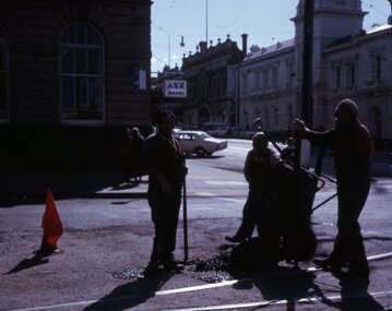
Slide - 27 mm sq slide/s - set of 2 - track workers, Lilian Butler, August or September 1971
... workers repairing the road surface the intersection of Sturt... road workers repairing the bitumen or road surface in Ballarat ...Yields information about SEC road workers repairing the bitumen or road surface in Ballarat.Set of two Colour 27 x 27 mm slides in a Kodachrome cardboard mount: .1 - Group of three SEC road repairer or track workers repairing the road surface the intersection of Sturt and Lydiard St with new asphalt mix. shows the red flag on the right - Sept. 1971 .2 - Group of three SEC road repairers, laying asphalt in Wendouree Parade, with the Road Roller and the concrete tram shelter at Forest St. in the background. - August 1971 Photo from the collection of Lilian Butler.ballarat, tramways, trams, trackwork, road works, sturt st, lydiard st north, wendouree parade, road roller, jelbart, shelters, forest st -
 Melbourne Tram Museum
Photograph - Fitzroy, Northcote & Preston Tramways Trust car number 1 in Plenty Road, early 1920s
... Road, Preston approaching a double track loop south of Bell... Road, Preston approaching a double track loop south of Bell ...Photograph of Fitzroy, Northcote & Preston Tramways Trust (FNPTT) R class tramcar No.1 northbound on single track in Plenty Road, Preston approaching a double track loop south of Bell Street. The photograph looks southward showing an unsealed road surface with a few horse drawn carts, span poles and overhead wires, tramways overhead light above loop turnout and low density shop fronts. While this tramcar and track were constructed for the FNPTT, the line was only operated by the Melbourne and Metropolitan Tramways Board from 1920. This car would soon be renumbered 151 and relocated to other lines Melbourne.Yields information about commencement of the Preston tram line and the Fitzroy, Northcote & Preston Tramways Trust. Black and white photograph with nothing on rearfnptt, r class, plenty road, preston, span poles, track loop, melbourne and metropolitan tramways board, fnptt number 1, tram number 151 -
 Melbourne Tram Museum
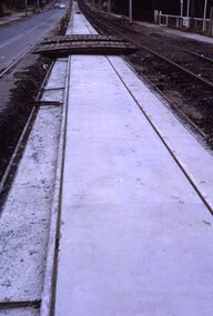
Slide - Set of 2, Keith Kings, 23/03/1968 12:00:00 AM
... Kooyong, Removable sections form the road surface and facilitate..., Removable sections form the road surface and facilitate maintenance ...35mm Kodak white cardboard colour slide by Keith Kings of 23/3/68 and 6/4/68. .1 - Glenferrie Road Kooyong track renewal showing the first section of completed track. Shows two road crossovers. .2 - ditto, showing one end of the new crossover with temporary track on the right. See Keith's slide notes.Keith Kings stamp and number "20-19" and "20-32", with details of exposure. 23/3/68 and 6/4/68. .1 - "New concrete trackwork in Glenferrie Rd north from Kooyong railway Xing ready to be brought into use. Temporary track still in use at right" .2 - "New design for xover in Glenferrie Rd, near cnr Gardiner Rd Kooyong, Removable sections form the road surface and facilitate maintenance and renewal."trams, tramways, glenferrie road, trackwork, temporary track, kooyong -
 Ballarat Tramway Museum
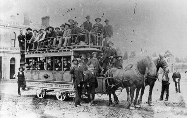
Photograph - Black & White Photograph/s, 1887/8
... of the road surface very rough - can't see the rails. Photo taken... of the roadway - lots of rocks on the road surface. Also shows an all ...Yields information about the early use of the Ballarat horse trams and condition of the roadway - lots of rocks on the road surface. Also shows an all male loading of passengers.Black and White copy photograph of a State Library of South Australia SLSA B34585 of an well loaded, only male passengers on a Ballaarat Horse Tram - Grenville and Sturt St. Two horse with many men, Wilson's Bucks Head Hotel in background. Condition of the road surface very rough - can't see the rails. Photo taken in early days, as no modesty boards on upper deck - say 1887. Possibly a trial trip. Collected by Alan Bradley from the State Library of South Australia early 1980's. Used in The Golden City and its Tramways - page 28.tramways, trams, sturt st, grenville st, bucks head hotel, horse tram -
 Glenelg Shire Council Cultural Collection
Photograph - Photograph reprint scan of Photograph - Henty Street Casterton 1920, Victoria, n.d
... Street. Casterton c.1920. Road not surfaced. Horse and cart.... Casterton c.1920. Road not surfaced. Horse and cart on right ...Vern McCallum CollectionReprint of scan of black and white photo. Image of Henty Street. Casterton c.1920. Road not surfaced. Horse and cart on right, another one making it's way along street. Car at left curb. Print is mounted on white archival mountboard. Frame. -
 Melbourne Tram Museum
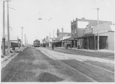
Photograph - Black & White Photograph/s, Bob Prentice, 13/11/1913 12:00:00 AM
... and the unfinished natures of the road surface. Photograph taken near... and the unfinished natures of the road surface. Photograph taken near ...Black and white photograph of the opening of the tramway along Glen Huntly Road, 13-11-1913. Shows the decorated tram and trams 53 and 63 along with others in the photograph and the unfinished natures of the road surface. Photograph taken near the Elsternwick railway level crossing - has the disc signal for the catch points in the foreground. Has the shop of Rankin and Ev?al chemist in the photograph. A similar Photograph features on page 61 of Ian Brady's book on the PMTT, "Melbourne's Foremost Municipal Tramway". Photograph from the Bob Prentice Collection. Has been removed from sheet with remains of the sheet on the rear with handwritten note on rear.trams, tramways, pmtt, glenhuntly rd, railway crossing, elsternwick, tram 53, tram 63 -
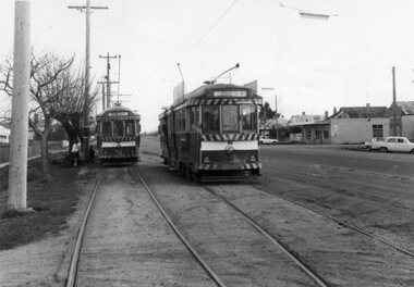
 Ballarat Tramway Museum
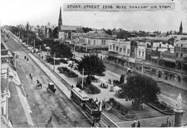
Photograph - Black & White Photograph/s, 1906
... and a number of pedestrians. Shows the newly formed tramway road... and a number of pedestrians. Shows the newly formed tramway road ...Black and white photograph of Sturt St. looking west from Town Hall 1906. Shows a ESCo tram hauling an ex-horse trailer (spelt "trailer"). Has some other horse drawn vehicles in photo and a number of pedestrians. Shows the newly formed tramway road surface, poles etc. Has "Snows" store sign on left hand side of photograph and buildings along the north side of the Sturt St. Other buildings shown are William Day & Son, Walter Connell, Anderson & Morse coach builders. See also Reg Item No. 1671 for the same item, but with out the typed note stuck on the top edge.trams, tramways, esco, sturt st., ballarat -
 Orbost & District Historical Society
black and white photograph, first half 20th century
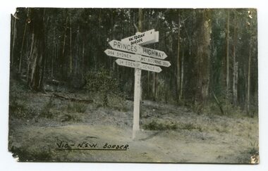
... , the road surface was anything but good, even by C1917 when cars..., the road surface was anything but good, even by C1917 when cars ...Prior to the sealing of the Princes Highway west of Orbost, the road surface was anything but good, even by C1917 when cars started to use the road. From Orbost the old road via Marlo to Sydenham was abandoned for the new location which traversed more rugged country via Cabbage Tree, Bell Bird and Club Terrace to Cann River, and the reason for this diversion was on account of settlements being established at Murrungowar and Club Terrace, at which latter place there was a temporary rush to obtain gold. This road was constructed by the Public Works department and a maximum grade of 1 in 19 was adopted, and as speed was not to be catered for the grade followed in and out round the spurs and gullies, resulting in a maze of turns and twists which required a good deal of skill on the part of the horse driver to negotiate." - Bairnsdale Advertiser, Friday, May 2, 1947. (More information from Newsletter February 2010)This is a pictorial record of an early road distance sign on a major highway through East Gippsland. The distances are indicated in miles, a measurement standard no longer in use.A black / white photograph postcard of the signpost at the Victorian - New South Wales border. It shows distances to Sydney and Eden on one arrow and distances to Melbourne and Genoa on another. on front - Vic - NSW Borderprinces-highway-east-gippsland road-transport road-sign -
 Orbost & District Historical Society
black and white photograph, late 19th century - early 20th century
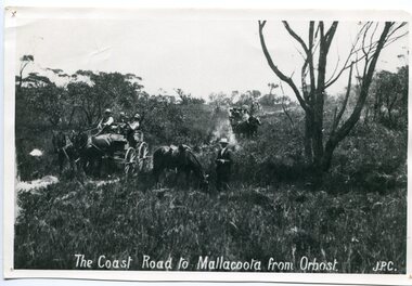
... , the road surface was anything but good, even by C1917 when cars..., the road surface was anything but good, even by C1917 when cars ...Prior to the sealing of the Princes Highway west of Orbost, the road surface was anything but good, even by C1917 when cars started to use the road. From Orbost the old road via Marlo to Sydenham was abandoned for the new location which traversed more rugged country via Cabbage Tree, Bell Bird and Club Terrace to Cann River, and the reason for this diversion was on account of settlements being established at Murrungowar and Club Terrace, at which latter place there was a temporary rush to obtain gold. This road was constructed by the Public Works department and a maximum grade of 1 in 19 was adopted, and as speed was not to be catered for the grade followed in and out round the spurs and gullies, resulting in a maze of turns and twists which required a good deal of skill on the part of the horse driver to negotiate." - Bairnsdale Advertiser, Friday, May 2, 1947. (More information from Newsletter February 2010)n the late 1800's early 1900's transporting goods by road was difficult and at times impossible because roads as thoroughfares did not exist.The means of travelling along the roads in the 1800's was by bullock wagon, horse pulled dray, pack horse or simply by foot. This road is still in use in East Gippsland as a part of many four-wheel-drive touring routes.A large black / white photograph of two horse - drawn wagons on a narrow sandy bush track. It is surrounded by scrub. There is one man standing beside a horse not harnessed to a wagon.on front - "The Coast Road to Mallacoota from Orbost JPC" -
 Coal Creek Community Park & Museum
Mine Map
... , tramways, boreholes, surface roads and (apparently) paddock..., tramways, boreholes, surface roads and (apparently) paddock ...6306.1 - Map of Outtrim mining area, with modification where damage/erasure has occurred. Shows tunnels, faults, tramways, boreholes, surface roads and (apparently) paddock boundaries and a creek. -
 Ballarat Tramway Museum
Photograph - Black & White Photograph/s, The Courier Ballarat, 30/09/1969 12:00:00 AM
... adjacent to the tram and the nature of the road surface... of the road surface. Collected by Alan Bradley from the Ballarat ...Yields information about Ballarat's tramway system at the point where the tram services to and from Sebastopol often crossed each other and the nature of Albert St itself at the time.Black and White copy photograph taken by The Courier, photo not published of No. 42 and 41 crossing at the Grey St Loop, in Albert St (Sebastopol) crossover, looking south. No. 41 has the destination of Lydiard St Nth, while No. 41 is proceeding to Lydiard St Nth . Presumably photographed 30/9/1969, at the same time as Reg. Item 3753. Shows the Albert St road looking south with a milk bar on the opposite side of the road, two children adjacent to the tram and the nature of the road surface. Collected by Alan Bradley from the Ballarat Courier early 1980's. See Excel file "Record of Ballarat Courier Photos SEC era" (Archive Documents) for source of details.On rear stamped "Copyright, The Ballarat Courier Proprietary Limited."tramways, trams, albert st, sebastopol, grey st loop, tram 42, tram 41 -
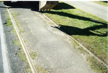 Ballarat Tramway Museum
Photograph - Colour Print/s - set of 10, Warren Doubleday, 13/09/2003 12:00:00 AM
... on Agfa Paper. 2603.1 - Road surface prior to commencement... - Road surface prior to commencement of excavation near pole 6 ...Set of ten colour photographs excavations around the rail head to examine sleeper condition in vicinity of poles 4 and 6 in Wendouree Parade, taken by Warren Doubleday on 13.09.2002. Printed on Agfa Paper. 2603.1 - Road surface prior to commencement of excavation near pole 6 2603.2 - About three sleepers excavated - noted poor sleeper nearest to camera. 2603.3 - vertical photo from above showing sleepers and foot of rail. 2603.4 - ditto 2603.5 - ditto 2603.6 - Backfilling with crushed rock near pole 6 - Alan Snowball, Richard Gilbert and Oedf Bylsma. 2603.7 - ditto 2603.8 - Excavation near pole 4. 2603.9 - ditto 2603.10 -ditto On rear of each photo in brown felt tip pen, the details of the location and some notes.wendouree parade, trackwork, st aidans drive -
 Orbost & District Historical Society
black and white photograph, 1918
... to the sealing of the Princes Highway west of Orbost, the road surface... to the sealing of the Princes Highway west of Orbost, the road surface ...Tonghi Creek is 66km north - west of Orbost. Prior to the sealing of the Princes Highway west of Orbost, the road surface was anything but good, even by C1917 when cars started to use the road. From Orbost the old road via Marlo to Sydenham was abandoned for the new location which traversed more rugged country via Cabbage Tree, Bell Bird and Club Terrace to Cann River, and the reason for this diversion was on account of settlements being established at Murrungowar and Club Terrace, at which latter place there was a temporary rush to obtain gold. This road was constructed by the Public Works department and a maximum grade of 1 in 19 was adopted, and as speed was not to be catered for the grade followed in and out round the spurs and gullies, resulting in a maze of turns and twists which required a good deal of skill on the part of the horse driver to negotiate." - Bairnsdale Advertiser, Friday, May 2, 1947. (More information from Newsletter February 2010)This item is a pictorial record of roads in the early 20th century in East Gippsland.A large black / white photograph of a bridge over a small creek, surrounded by bush. The photograph is mounted on a thick cream coloured card.on back - "Bridge at Tonghi Creek 1918"tonghi-creek-bridge country-roads-east-gippsland -
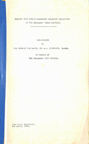 Ballarat Tramway Museum
Document - Report, City of Ballaarat, "Submission to Enquiry into Public Transport Facilities in the Ballarat Urban District by A. W. Nicholson, Mayor of Ballaarat Council", Apr. 1968
... , employment, road surface repairs, financial loss to the SEC..., road surface repairs, financial loss to the SEC, reduction ...Yields information about the view of the City of Ballaarat in 1968 about the possible replacement of tram service.Report or Submission - 6 Gestener printed foolscap sheets, stapled on left hand side and bound with a blue edging tape titled "Submission to Enquiry into Public Transport Facilities in the Ballarat Urban District by A. W. Nicholson, Mayor of Ballaarat Council". Dated 2 April 1968. Submission looks at the possible closure or the future of the tramway system, the SEC involvement, employment, road surface repairs, financial loss to the SEC, reduction in passengers due to car ownership. Council submitted that the tramway system should be retained and extended and that pensioner concessions should be continued. Notes that at the time 69 men on the trams, 18 at the depot and 8 on the track. If replaced by buses, supported a government owned bus provider rather than private. Document scanned - word searchable. pdftrams, tramways, closure, city of ballaarat, bus replacement, public transport, sec, finances -
 Ballarat Tramway Museum
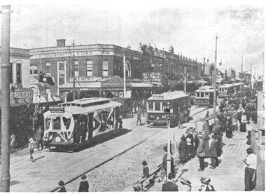
Postcard, John Phillips, Doveton St. and Sturt St
... , road surface different and trees have leaves. 1 copy held..., road surface different and trees have leaves. 1 copy held ...B&W print and scanned images of a coloured postcard lent to the BTM by Mr. Norm DePomeroy, Dec. 1997. Image is an ESCo tram near the intersection of Doveton St. and Sturt St. travelling west along the south side of Sturt. Steet. Photo taken soon after opening of the electric trams. Shows buildings along the north side of Sturt St. and the building at the SE corner of Doveton St. ESCo tram has destination board on the front dash of the tram. Note very similar to item 834, but shadows are different, road surface different and trees have leaves. 1 copy held at 8/98. Postcard posted 25/7/1907. See Reg item 4004 for another postcard using this image within a map of Australia. See 838i3. In top of image are the words "Sturt Street, Ballarat"trams, tramways, esco, sturt st, postcards, doveton st -
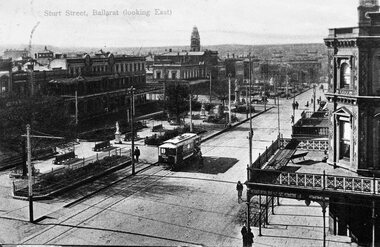
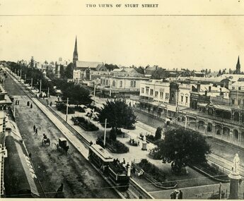 Ballarat Tramway Museum
Photograph - Black & White Photograph/s, 1906
... of pedestrians. Shows the newly formed tramway road surface, poles etc... of pedestrians. Shows the newly formed tramway road surface, poles etc ...Black and white photograph of Sturt St. looking west from Town Hall 1906. Shows a ESCo tram hauling an ex-horse trailer . Has some other horse drawn vehicles in photo and a number of pedestrians. Shows the newly formed tramway road surface, poles etc. Has "Snows" store sign on left hand side of photograph and buildings along the north side of the Sturt St. Other buildings shown are William Day & Son, Walter Connell, Anderson & Morse coach builders. On the top of the item is the words "Two Views of Sturt St.". See also Reg Item No. 888 for the same item, but with a typed caption note stuck on the top edge. See Reg Item No. 2784 for the other "Two Views of Sturt St." image.trams, tramways, esco, sturt st., ballarat -
 Melbourne Tram Museum
Photograph - Scrubber No 5 Preston Workshops, 1934
... Trust in 1917-1918 to control dust on partly surfaced roads... to control dust on partly surfaced roads. Converted by the MMTB ...Photo shows MMTB Scrubber No. 5 at Preston Workshops. The tram was constructed by the Melbourne & Brunswick Tramways Trust in 1917-1918 to control dust on partly surfaced roads. Converted by the MMTB to a scrubber in 1932, and withdrawn during 1959 and scrapped during 1966.Yields information about MMTB Scrubber trams.Black and white on Kodak papertramways, trams, scrubber 5, mbctt -
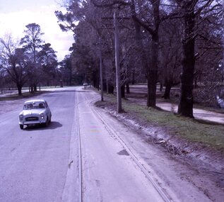
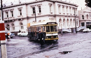 Ballarat Tramway Museum
Slide - 35mm slide/s, mid to late 1960's
... . The road surface is wet. Has the Ballarat Post Office.... The road surface is wet. Has the Ballarat Post Office ...Agfa plastic mount (blue base, white cover) of a photograph of No. 43 at corner of Sturt St and Lydiard St, on the curved track into Lydiard St. North with both poles down, front truck derailed. A policeman is walking at the back of the tram - controlling traffic. The road surface is wet. Has the Ballarat Post Office in the background. Tram has the destination of Lydiard St. North. Photo taken mid to late 1960's. Tramcar has a SEC "Everything's under control in my all electric kitchen" roof advertisement. The slide could be a copy slide, given the nature of the colour and the additional number WP410. Photographer could be Bill Pearce (WP). Slide rescanned at 3200 dpi 25-10-2020, jpg replaced, tiff file retained. This file was scanned in 2003 and may show colour changes."BAS 53 in penciltramways, trams, lydiard st north, sturt st, derailments, accidents, tram 43 -
 Ballarat Tramway Museum
Slide - 27 mm sq slide/s - set of 9 - tram tracks - Gardens to the City, Lilian Butler, Aug. 1971
... the road surface. .7 - at Dawson St showing the tram stop and End... the road surface. .7 - at Dawson St showing the tram stop and End ...Yields information about the streetscapes of Ballarat on the Gardens to Victoria St route and in particular buildings and people that crewed the trams.Set of nine Colour 27 x 27 mm slide in a Kodachrome cardboard mount of a series of photographs taken from Wendouree Parade in the Gardens to the City tramway - taken from the front or rear window of the tram. .1 - Carlton St loop looking north .2 - Wendouree Parade, north of the Windmill Drive north intersection - has a tram stop pole. .3 - Sturt St - in bound just past Pleasant St - has passengers waiting at the tram stop. .4 - at Ascot St. .5 - at Drummond St with Shell garage in the view and a track worker. .6 - at Talbot St? with track workers repairing the road surface. .7 - at Dawson St showing the tram stop and End of Section signs. .8 - nearing the intersection with Armstrong St. .9 - nearing Lydiard St. Slide mount date cannot be read - possibly August 1971. Photo from the collection of Lilian Butler.ballarat, tramways, trams, wendouree parade, sturt st, drummond st, trackwork, tram stops, carlton st loop -
 St Kilda Historical Society
Photograph, St Kilda Junction with Old Police Paddock, c. 1858
... and canoe tree? Date unknown, but before bitumen surfacing of roads...? Date unknown, but before bitumen surfacing of roads -- pre 1900..., but before bitumen surfacing of roads -- pre 1900? Copy courtesy ...on back: St Kilda Junction showing old police paddock and canoe tree? Date unknown, but before bitumen surfacing of roads -- pre 1900? Copy courtesy LaTrobe Library, Melbourne Handwritten: about 1858copy of(?) black and white photograph fair condition unmountedSt Kilda Junction showing old police paddock and canoe tree? Date unknown, but before bitumen surfacing of roads -- pre 1900? Copy courtesy LaTrobe Library, Melbourne Handwritten: about 1858 -
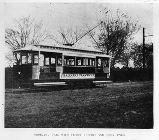 Ballarat Tramway Museum
Photograph - Black & White Photograph/s - set of 2, 1905
... the nature of the road surface at the time, c1905. The print... the nature of the road surface at the time, c1905. The print ...B&W photograph of the one of the ESCo California Combination tramcars at the time of the opening of the service, photographed most likely in Wendouree Parade, near the dept. Shows bracket arm in background, trolley pole and head. Also shows the nature of the road surface at the time, c1905. The print for this photograph made from a copy negative of page 454 of the Australasian, August 19, 1905 in 1993. Print includes caption "ORDINARY CAR, WITH CLOSED CENTRE AND OPEN ENDS" See Reg. Item No. 763. Photo has been mounted onto a styrene card with card sides and Velcro strips on the top edge for display purposes. Mounted Oct. 1993 for the CHHA Exhibition, theme "Made in Australia". 762.1 - added 6/12/2004. Same print with details of source written on the rear. ARHS Vic. Div. Photo Number 771/23, ex Latrobe Library. Not as good as print as above. Cropped at base - does not have caption. See Alan Bradley, draft Chapter 3 of the history of Ballarat Tramwaystrams, tramways, esco, tramcars, ballarat -
 Ballarat Tramway Museum
Slide - 27 mm sq slide/s - set of 11, Lilian Butler, Wendouree Parade and Sturt St West, Sep. 1971
... intersection - showing road surface, a tram coming towards... intersection - showing road surface, a tram coming towards ...Yields information about the streetscapes of Ballarat depot to Pleasant St route and in particular buildings and people that crewed the trams.Set of eleven Colour 27 x 27 mm slide in a Kodachrome cardboard mount. .1 - Wendouree Parade looking west towards St Aidans Drive - the gate pillars can be seen. .2 - ditto looking west - Fairyland .3 - ditto looking towards Gardens Loop .4 - No. 41 at Gardens Loop, with destination of Gardens via Drummond North .5 - ditto showing Mt Pleasant .6 - ditto, just past the now BTM Depot Junction. .7 - Carlton St - showing the gates .8 - Looking towards Hamilton Ave from within Carlton St loop with the signal showing red. .9 - Turning from Hamilton Ave into Sturt St West. .10 - Sturt St west looking east with the Loreto convent walls on the left hand side. .11 - Sturt St - Pleasant St intersection - showing road surface, a tram coming towards the intersection and buildings on either side. Slide mount date September 1971. Photo from the collection of Lilian Butler.ballarat, tramways, trams, wendouree parade, st aidans drive, gardens loop, depot junction, carlton st, carlton st loop, signals, sturt st west, pleasant st, tram 41 -
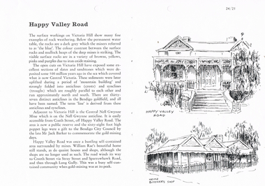 Bendigo Historical Society Inc.
Document - LONG GULLY HISTORY GROUP COLLECTION: HAPPY VALLEY ROAD
... Titled Happy Valley Road. Describes surface workings... Shop Titled Happy Valley Road. Describes surface workings ...Titled Happy Valley Road. Describes surface workings on Victoria Hill and the different colours of the rocks, the formation of the anticlines and the synclines which are roughly parallel and run approximately north and south. They are all named and make the lines on the Bendigo Goldfield. Adjacent to Victoria Hill is the Central Nell Gwynne Mine which is on the Nell Gwynne anticline. There were quaint houses and shops in Happy Valley Road, although the shops are no longer used as such. On the right are two sketches, one an old house and below it is Heinz Butcher's Shop.bendigo, history, long gully history group, the long gully history group - happy valley road, victoria hill, central nell gwynne mine, bendigo city council, mr jack barker, william rae, heinz butcher's shop -
 Nillumbik Shire Council
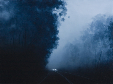
Painting: Camilla TADICH, Camilla Tadich, 6.23am Kangaroo Ground, 2009
... ; atmospheric states, fog and dampness and the nature of surfaces... and the nature of surfaces, vegetation, road, vehicles and buildings. She ...Tadich spends time observing night time phenomena, the light from the moon, street lights and other sources; atmospheric states, fog and dampness and the nature of surfaces, vegetation, road, vehicles and buildings. She uses photographs and sketches before settling on the final idea for a work.This painting is typical of Tadich's recent work. She continues her exploration of the Australian landscape (most often the local, Nillumbik Shire). It is 'a dramatic interplay between narrative, landscape and the binaries of light/dark and the known/unknown of local landscape. The swathes of darkness within the work(s) pose questions about our inscribed fears and tensions, both cultural and existential'. (catalogue, 'Silent Space' Ex. 2006) Tadich's early experiences of fireworks, simple fireworks and bonfire in the surrounding bush of her outer Melbourne home, caught her imagination. She was inspired to investigate the issues surrounding nights in the bush. In this painting the narrative is ambiguous, the pinpricks of light, in this case from the car headlights provide a critical element. We can distinguish familiar features, a road, trees and a car that suggest human presence. However, what is going on is unclear. The resulting tension can leave us unsure, unsettled and anxious.Oil on canvascamilla tadich, nillumbik shire council, kangaroo ground -
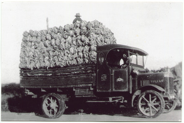 City of Moorabbin Historical Society (Operating the Box Cottage Museum)
Photograph, Black & White, V Peterson, loaded Vulcan Truck 1929, c1929
... to transport their crops. Roads were being surfaced but ruts... Cottage Museum) Joyce Park Jasper Road Ormond melbourne ...The Peterson family were early settlers in Moorabbin Shire and established a market garden in East Boundary Road East Bentleigh. Horse drawn wagons traveled along Plateways to take their crops to the Melbourne Markets . With the advent of the motorcar the market gardeners gradually purchased trucks to transport their crops. Roads were being surfaced but ruts and flooding caused upsets and bogging of these trucks. The journey was quicker but unlike the Horses, these trucks could not drive themselves back to the farm.The early settlers like the Petersons and Marriotts, in the Parish of Moorabbin County of Bourke after Henry Dendy's Special Survey Brighton 1841, established market gardens, fruit & flower gardens, poultry & dairy farms, vineyards as well as shop businesses, blacksmiths, chemists, nursing homes and schools & Churches.Black & White photograph of a Vulcan truck driven by Vic Peterson, loaded with Cauliflowers from his market garden in East boundary Road East Bentleigh c 1929.Back Handwritten information unsgnedwagons, vulcan trucks, draught horses,, peterson vic, marriott dick, cauliflower crops, vegetable crops, poliomyelitis epidemics 20thc , elster creek, plateways moorabbin shire, smith j l; smith mary ann, stanley helen, smith vic chaff cutter, horse drawn carts, toll gates brighton, motor cars 1900, steam engines, early settlers, bentleigh, mckinnon, parish of moorabbin, city of moorabbin, county of bourke, moorabbin roads board, shire of moorabbin, henry dendy's special survey 1841, were j.b.; bent thomas, o'shannassy john, king richard, charman stephen, highett william, ormond francis, maynard dennis, market gardeners, vineyards, orchards -
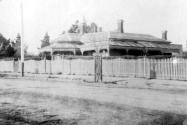 Surrey Hills Historical Society Collection
Photograph, 215 Union Road, c 1920
... diagonally across the road. Shows street surface, bluestone kerbing... Road from diagonally across the road. Shows street surface ...The house was variously known as ‘Mintaro’, ‘Montiere’ and ‘Goonoo Goonoo’, the later after 1920 when it was purchased by Natale Cerini and his wife Ethel May (nee Swan), who were married in 1918. Built 1887-1888 by William Wigley. The original colour was deep cream with dark green trim. Property included a block of land on south side and also land to the north. The original coach house was on what became 213 Union Road and was used to build a yacht in by the then neighbours, the Flemings. The street plane trees were replaced in the 1970s with melaleucas and in 1987 new plane trees were planted between the melaleucas. Sepia copy of an older photo of 215 Union Road from diagonally across the road. Shows street surface, bluestone kerbing, a young tree within a guard and a Victorian style home with 3 chimneys, a slate roof and a veranda on at least the south and west side. Beyond the house are mature cypress and other trees and a spire. The spire belonged to Surrey College, a boys' boarding school (later Nethercourt Hospital and St Judes.)'mintaro', 'montiere', 'goonoo goonoo', william wigley, mrs ethel may cerini, miss ethel may swan, miss jocelyn cerini, mrs jocelyn hall, miss lynette cerini, victorian style, 215 union road -
 Bendigo Military Museum
Photograph - Johnson Ground Elevation Meter (JGEM) Survey Vehicle - Army Survey Regiment, Fortuna, Bendigo, c1960s
... and the road surface alongside the JGEM’s fifth wheel was measured... and the road surface alongside the JGEM’s fifth wheel was measured ...This is a set of 16 photograph of the Royal Australian Survey Corps’ Johnson Ground Elevation Meter (JGEM) Survey Vehicle taken at the Army Survey Regiment, Fortuna, Bendigo. The JGEM vehicle was extensively used by RA Svy within Australia from the late 1960s. A limited number of Ground Elevation Meter (GEM) station wagon type vehicles were manufactured by General Motors Corporation (GMC) in the USA for the United States Geological Survey, Canada’s mapping agencies, RA Svy and National Mapping (Natmap). The GEM was a four-wheel drive, four-wheel steer vehicle. Four-wheel steering was necessary to avoid systematic errors caused by non-tracking of front and rear wheels on conventionally steered vehicles. The manufacturer substituted the rear axle with a front axle and connected them to form the four-wheel steering mechanism. The two Australian GEM vehicles, referred to as Johnson GEMs (JGEMs) were converted into right-hand drive. After delivery in 1964, acceptance Natmap and RA Svy testing and operator training was undertaken at the Army's School of Military Survey located at Balcombe, Victoria. A small fifth wheel was mounted on a cantilever arm suspension midway between the front and rear wheels on the right side of the vehicle. It was lowered to and raised from its operating position by use of a constant pressure air cylinder. A telescopic bar, suspended between the front and rear axles, provided the reference datum for the angle measurement. The wheel provided the velocity or distance signal through a pulse generator system. A sensitive pendulum mounted on this bar provided the angle measurement for each minute distance traversed. The JGEM contained electromechanical instruments used to determine relative elevations, by trigonometric principles, along a traversed path. These relative elevations were obtained through apparatus which measures the instantaneous angle of inclination of the road and the instantaneous velocity of the meter along such a path. Road routes over which the JGEM operated were planned so that each started and ended as near as practicable to an existing point of known elevation (formally referred to as a level traverse bench mark). The difference in height from the bench mark and the road surface alongside the JGEM’s fifth wheel was measured with a level and staff. Along each route, mapping control photo reference points where new elevation values were required were identified on aerial photographs. Under favourable conditions it was possible to survey as much as 160km in an ordinary working day. The first of RA Svy’s JGEM operations was undertaken in 1:250,000 scale map areas of Queensland. CPL John Hook was the JGEM’s main operator in the early 1970s undertaking operations covering 1:250,000 scale map blocks over northern Victoria and central NSW, each requiring 36 points (9 runs of photography and 4 points across. SPR Lyn Thompson and SPR Bob McDonagh teamed with CPL Hook on some of these JGEM operations. When RA Svy was integrated into the Royal Australian Engineers in 1996, the JGEM vehicle with the Survey Corps collection was donated to its museum. It is believed to be the last of the original manufactured fleet in existence. The JGEM has undergone extensive refurbishment to achieve roadworthiness and is currently housed at The Australian Army Museum of Military Engineering, Hoslworthy Barracks, NSW. It can be viewed by making an appointment with the museum’s curator.This is a set of 16 photograph of the Royal Australian Survey Corps’ Johnson Ground Elevation Meter (JGEM) Survey Vehicle taken at the Army Survey Regiment, Fortuna, Bendigo. The photographs were on 35mm slide film and were scanned at 96 dpi. They are part of the Army Survey Regiment’s Collection. .1) - Photo, colour, c1960s, Johnson Ground Elevation Meter (JGEM) Survey Vehicle .2) - Photo, colour, c1960s, JGEM instrumentation, on-board computer. .3) - Photo, colour, c1960s, JGEM instrumentation. .4) - Photo, colour, c1960s, JGEM instrumentation, on-board computer. .5) - Photo, colour, c1960s, JGEM tyre pressure controller .6) - Photo, colour, c1960s, JGEM rear doors, SGT Geoff Briggs. .7) - Photo, colour, c1960s, JGEM 5th wheel distance/angle measurement device in lowered position, SGT Geoff Briggs. .8) - Photo, colour, c1960s, JGEM 5th wheel distance/angle measurement device in lowered position. .9) & .10) - Photo, colour, c1960s, JGEM tyre pressure system, SGT Geoff Briggs. .11) - Photo, colour, c1960s, JGEM tyre pressure system. SGT Geoff Briggs. .12) - Photo, colour, c1960s, JGEM levelling scope, levelling staff, unidentified technicians. .13) & .14) - Photo, colour, c1960s, JGEM levelling scope, unidentified technician. .15) & .16) - Photo, colour, c1960s, probably survey operation adjusted height plotted on block base sheet. .1P to .16P - Some of the equipment is annotated on the frame of the 35mm slides.royal australian survey corps, rasvy, army survey regiment, army svy regt, fortuna, asr, surveying -
 The Beechworth Burke Museum
Geological specimen - Basalt, Unknown
Basalt is a common igneous rock that composes most of the Earth's surface and can be found on the Moon and other rocky planets of the Solar System. It is generally composed minerals such as calcic plagioclase, clinopyroxene and iron ore which form grains that are indistinguishable to the naked eye. It can be dark grey or black in colouring and sometimes may contain holes left by gas bubbles. Most of the Earth's basalt was produced in environments such as oceanic divergent boundaries, oceanic hotspots, and mantle plumes and hotspots beneath continents. Basalt is commonly used in construction where it is crushed and used for multiple purposes such as concrete aggregate, road base, or railroad ballast. Thin slabs of basalt can also be cut and used for floor tiles, stone monuments, and building veneer. This particular specimen was excavated from Talbot in Victoria, which was a small gold mining town established in 1852. As basalt is a common rock, it is not specific to Talbot. However, this specimen can be assumed to be of the Cainozoic age due to previous geomorphic surveys of the area. This particular type of Basalt was used mainly for roads due to the durability of the rock.Basalt holds significance due to the continued use of the rock from historic until present times. The rock has been utilised for many types of construction and is still used for the same purposes today. Basalt also has significance to the Earth and other rocky planets of the Solar System as it makes up most of the planet's surface. This specimen is part of a larger collection of geological and mineral specimens collected from around Australia (and some parts of the world) and donated to the Burke Museum between 1868-1880. A large percentage of these specimens were collected in Victoria as part of the Geological Survey of Victoria that begun in 1852 (in response to the Gold Rush) to study and map the geology of Victoria. Collecting geological specimens was an important part of mapping and understanding the scientific makeup of the earth. Many of these specimens were sent to research and collecting organisations across Australia, including the Burke Museum, to educate and encourage further study.A smaller than hand sized rock specimen which is dark grey in colour with small holes and white deposits across its surface.Geological survey / [illegible] /burke museum, beechworth, geological specimen, geology, basalt, basalt specemin, indigo shire, talbot, cainozoic, igneous rock -
 The Beechworth Burke Museum
Audio - Oral History, Jennifer Williams, Evelyn Jensen, 13th April 2000
Miss Evelyn Jensen was born in 1908 near Mytleford Road in Beechworth. Miss Jensen was a twin but she also had twelve brothers and sisters. Miss Jensen went to school when she was nine years old but did not enjoy it. Her father was a nozzleman and had a role in finding and collecting gold. More specifically, a nozzleman operated a steel barrel with an interchangeable brass nozzle that sprayed high pressure water onto rock and similar surfaces. This broke down the surface for gold to be found. Unfortunately, when he began most of the gold was already gone. Miss Jensen's mother died when Miss Jensen was sixteen. As a result, Miss Jensen had to take care of the children and run the house. This included looking after a few months old baby. Her father was away at work most days so all of the responsibility fell on her. Her grandmother was present but she was too old to help Miss Jensen. Miss Jensen and her family lived a very long way from the main town and often had to carry kerosene tins full of water half a mile to their house. This was because they have no access to water at their home. This lack of water also meant they had to either bathe in the creek or carry the water back home for a bath. On wash day, they washed their clothes in the creek too. Miss Jensen never married but continued to provide for her family. She spent her days gardening and cooking. They did not have much money so gardening was a way that they provided food for themselves. This oral history recording was part of a project conducted by Jennifer Williams in the year 2000 to capture the everyday life and struggles in Beechworth during the twentieth century. This project involved recording seventy oral histories on cassette tapes of local Beechworth residents which were then published in a book titled: Listen to what they say: voices of twentieth century Beechworth. These cassette tapes were digitised in July 2021 with funds made available by the Friends of the Burke.Miss Jensen's oral history is significant because it demonstrates the struggles of living remotely during this early part of the twentieth century. When Miss Jensen's mother died, she had to take on a lot of responsibility and did not have much support. This history sheds light on these struggles of being a young caregiver but it also gives details on how large families lived in isolated places. An example of this is the way that Miss Jensen often had to do the washing in the creek because that was the only place there was running water. In addition, Miss Jensen's story is significant because her father was a nozzleman. It indicates one of the processes was used to find gold. This oral history account is socially and historically significant as it is a part of a broader collection of interviews conducted by Jennifer Williams which were published in the book 'Listen to what they say: voices of twentieth-century Beechworth.' While the township of Beechworth is known for its history as a gold rush town, these accounts provide a unique insight into the day-to-day life of the town's residents during the 20th century, many of which will have now been lost if they had not been preserved.This is a digital copy of a recording that was originally captured on a cassette tape. The cassette tape is black with a horizontal white strip and is currently stored in a clear flat plastic rectangular container. It holds up 40 minutes of recordings on each sideEvelyn Jensen /mytleford road, beechworth, three mile creek, three mile beechworth, twin, nozzleman, goldrush, gold rush, work, mother, young mother, children, siblings, baby, grandmother, father, isolation, bush, water, watertanks, kerosene tins, wash day, bath day, creek, gardening, provide, poor, money, oral history, twentieth century, recording, story -
 The Beechworth Burke Museum
Photograph, 1960s
This photograph was taken in the 1960s at Lake Sambell Caravan Park and visible in the photograph are individual caravan sites with electricity outlets, a large single-story building with a caravan park banner, dirt roads, a freestanding message board, and a parked car. Lake Sambell Caravan Park opened in 1959 owing to the work of R.E. Carter, Beechworth Shire engineer from 1954-63. Carter advocated for improvements to the lake and surrounding area in order to encourage tourism in Beechworth. The opening of the caravan park was part of many improvements to Lake Sambell made in this period by Carter including: the swimming pool in 1961, water skiing and boating facilities, and increased lake surface in 1964. These improvements were financed mainly by grants from the Tourist Development Authority. The popularity of caravanning in Australia exploded during this post-war period of the late 1950s and 1960s. This popularity was driven by multiple factors, including: the stopping of fuel rations, the accessibility of car ownership through the manufacturing of affordable cars, technological developments in caravan design, and the increase in prosperity and leisure time for many Australians. Facilities such as electrical outlets to power caravans are present in this photograph of Lake Sambell Caravan Park. Lake Sambell is an artificial lake that was developed on the previous site of the Rocky Mountain Mining Company workings and was officially opened by Minister for Lands, Mr Baily, on October 5, 1928. The disused and unattractive remains of the mine were converted into a recreational area intended for swimming, boating, and fishing. The lake is named after Mr L.H. Sambell, shire engineer and secretary of the Forward Beechworth Committee, who advocated for the enhancement of Beechworth into a tourist destination and was central to the planning and establishment of the lake. This photograph is of historical and social significance in providing insight into caravanning during the 1960s in Australia. Caravanning was extremely popular during the 1960s in Australia due to multiple social and economic factors including the stopping of fuel rations, the accessibility of car ownership through the manufacturing of affordable cars, technological developments in caravan design, and the increase in prosperity and leisure time for many Australians.Black and white rectangle photograph printed on photographic paper and unmounted.Reverse: 3536/ [logo back printing: KODAK/ VELOX/ PAPER] / C798 lake sambell caravan park, lake sambell, caravanning 1960s, caravan park, rocky mountain mining company, kodak velox paper, r.e. carter, l.h. sambell, caravan electricity outlets, tourist development authority, post-war prosperity, forward beechworth committee, lake sambell boating, lake sambell swimming pool, lake sambell fishing, artificial lake, travel 1960s, recreation 1960s