Showing 44 items matching "roof shingles"
-
 Ringwood and District Historical Society
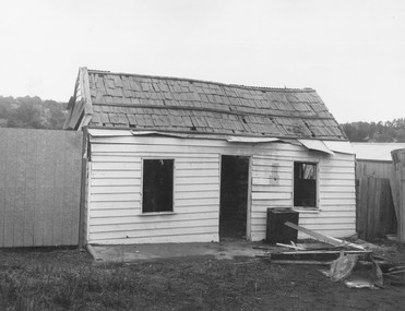
Photograph, Dismantling Ringwood miners cottage in 1975
Typed below photograph, "The Ringwood miners cottage - 18873. Formerly at no.367 Maroondah Highway opposite Civic Centre. Shown during dismantling after iron roof taken off to reveal original hand split wooden shingles. April 1975". -
 City of Moorabbin Historical Society (Operating the Box Cottage Museum)
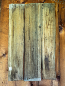
Buildings, Shingles Original Cottage c1850, c1850
... 3 x wood Shingles used on roof of Box Cottage c 1850... used on roof of Box Cottage c 1850 Buildings, Shingles Original ...The original small, pioneer cottage was built in the late 1840s to early1850s, by an unknown pioneer. It was located on part of a 30 Acre allotment that was originally part of Henry Dendy’s 'Special Survey Brighton' granted in 1841 (5120acres). There is a small display of external cladding shingles from the original pioneer cottage. Wooden shingles were usually thin (3⁄8 to 3⁄4 in or 10 to 19 mm), relatively narrow (3 to 8 in or 76 to 203 mm), of varying length (14 to 36 in or 360 to 910 mm), and almost always planed smooth. The traditional method for making wooden shingles was to rive - hand split - them from straight-grained knot-free sections of logs pre-cut to the desired length known as bolts. These bolts were quartered or split into wedges. A mallet and axe were used to split out thin pieces of wood. The wood species varied according to available local woods, but only the more durable inner section of the log was usually used. The softer sapwood generally was not used because it deteriorated quickly. Because hand-split shingles were somewhat irregular along the split surface, it was necessary to dress or plane the shingles to make them fit evenly on the roof. This reworking was necessary to provide a tight-fitting roof over typically open shingle lath or sheathing boards. These are the original shingles found on Box Cottage by L Lewis 1970 and used in the reconstruction in 19843 x wood Shingles used on roof of Box Cottage c 1850box cottage museum ormond, henry dendy special survey brighton 1841, brighton, moorabbin shire, parish of moorabbin, county of bourke,cottages, pioneers, ormond, colonial, mckinnon, dendy henry, box william, box elizabeth, reitman william, convicts, lewis timber co. ltd., deam h, museums, box alonzo, smith a, -
 Victorian Interpretive Projects Inc.
Photograph - colour, Clare Gervasoni, House with shingle roof in Lydiard (North) Street, Ballarat, 2014, 18/01/2015
... shingles. House with shingle roof in Lydiard (North) Street ...Although this house has been clad and had an iron roof put onto it, the historical integrity still appears to be intact. Colour photograph of a clad weatherboard house in Lydiard (North) Street Ballarat. Some of the iron roofing has been removed exposing shingles.weatherboard, shingles, lydiard street, house -
 Clunes Museum
Photograph, C 1920
... SHINGLES ON A ROOF.... STREET,CLUNES, PROBABLY TAKEN ABOUT 1920'S. NOTE SHINGLES ...FRASER STREET,CLUNES, PROBABLY TAKEN ABOUT 1920'S. NOTE SHINGLES ON A ROOF.BLACK AND WHITE PHOTOGRAPH OF PART OF FRASER STREET, CLUNES. SCHOOL ON HILL IN BACKGROUND.TAKEN ABOUT 1920'S MAYBE MUCH EARLIER. NOTE SHINGLE ROOF.local history, photography, photographs, clunes township. -
 Southern Sherbrooke Historical Society Inc.
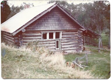
Photograph - Former Edebohls family home, Narre Warren East
Two colour photographs showing a log cabin amongst trees. It was owned by the Edebohls family. The walls are made of logs, the gable ends have wooden shingles, and there is a more recent tin roof with the original shingle roof underneath the tin. There is a verandah on the downhill side of the house. Trees surround the house. The house is opposite Kerrs Park and is believed to be the oldest house left in Narre Warren East. -
 Kew Historical Society Inc
Photograph - 'Reno', 10 St John's Parade, John T Collins, 1977
‘Reno’, stood on the east side of St John’s Parade. Its earliest recorded owner was the architect Samuel Cocking who lived there from c.1865 until his death in 1888. The original landholding was bordered by Cotham Road, Glenferrie Road, Wellington Street, and Charles Street. The southern portion of this land included a fine orchard, with many imported trees. The old summer house, at first in the orchard, was later removed to the house garden. The MMBW Detail Plan No.1576 (1904) shows the remaining portion of the original land holding, including a semi-circular pathway at the front, and garden features such as an aviary, a fountain and grotto, and a fernery. The garden including rare plants supplied by Baron Von Mueller, surrounds the cottage in a tangled frenzy. Despite a ‘local significance’ classification by the National Trust, the house was demolished in 1977.Partial view, north side of the weatherboard cottage in St John's Parade, Kew, known as 'Reno' (demolished 1977). Architectural elements revealed in this photo by John T Collins include: two wing, hip roof construction; external buildings at angles to main wing; corrugated iron roofing [over shingles]; brick chimney external to building; unvarnished/unpainted external weatherboards. General dilapidated condition. "Kew 'Reno' 10 St Johns Pde / John Collins, 11 Anderson Road, Hawthorn East, 3123, Film 35B Exposure 27"reno - st john's parade -- kew (vic.), john t collins -
 Kew Historical Society Inc
Photograph - 'Reno', 10 St John's Parade, John T Collins, 1977
‘Reno’, stood on the east side of St John’s Parade. Its earliest recorded owner was the architect Samuel Cocking who lived there from c.1865 until his death in 1888. The original landholding was bordered by Cotham Road, Glenferrie Road, Wellington Street, and Charles Street. The southern portion of this land included a fine orchard, with many imported trees. The old summer house, at first in the orchard, was later removed to the house garden. The MMBW Detail Plan No.1576 (1904) shows the remaining portion of the original land holding, including a semi-circular pathway at the front, and garden features such as an aviary, a fountain and grotto, and a fernery. The garden including rare plants supplied by Baron Von Mueller, surrounds the cottage in a tangled frenzy. Despite a ‘local significance’ classification by the National Trust, the house was demolished in 1977.Partial view, side of the weatherboard cottage in St John's Parade, Kew, known as 'Reno' (demolished 1977). Architectural elements revealed in this photo by John T Collins include: hip roof construction; corrugated iron roofing [over shingles]; unvarnished/unpainted external weatherboards; Externally opening 1860s-style casement window. General dilapidated condition. "Kew 'Reno' 10 St Johns Pde / John Collins, 11 Anderson Road, Hawthorn East, 3123, Film 35B Exposure 26"reno - st john's parade -- kew (vic.), john t collins -
 Stawell Historical Society Inc
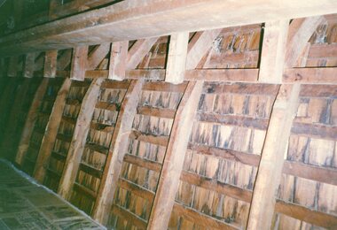
Photograph, Crowlands Hotel before demolition showing Wooden Shingles on the inside of the roof -- 2 Photos -- Coloured
Building Detail. Two photographs of Wooden Shingles from inside. Crowlands Hotel before demolition.stawell -
 Surrey Hills Historical Society Collection
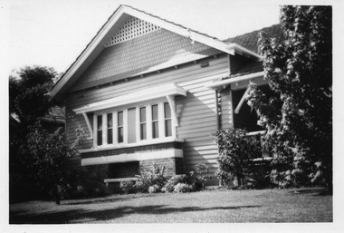
Digital photo, George L Coop, 688 Whitehorse Road, Mont Albert c 1953, c1953
This was the home of 3 generations of the Coop family: 1. Josephine and George Frank Coop (noted in Box Hill Rate Books for 1947-1954). 2. George Burton Coop (1906-1960) and his family. He was Assistant Chief Architect of Victoria in the Public Works Department (P.W.D.) George Burton Coop was born in c1906 in Williamstown, the son of Josephine Vistarini and George Frank Coop. He married Winifred Alice Trewartha in 1936 and they are listed in the electoral rolls at 688 Whitehorse Road in 1937. George died 3/4/1960, aged 54 years at Mont Albert. 3. George Burton and Alice Coop had 2 children: George Lister Coop - born St Georges Hospital, 8/10/1937 Alison - born c1945. The donor George Lister Coop informed that he initially attended Chatham State School because his first home was the Spanish Mission style flats at 346 Whitehorse Road, opposite Brenbeal Street, Balwyn. When his grandparents died, the family moved to 688 Whitehorse Road and he then attended Mont Albert Central School. The California bungalow style of housing was the dominant style of housing built in the interwar period through the northern parts of Surrey Hills and Mont Albert as formerly semi-rural land was subdivided for new housing. It was relatively inexpensive and affordable. In Australia the Californian bungalow drew upon elements that were popular across the United States from around 1910 to 1939. In Australia the style became popular from 1913. In Melbourne both timber and red brick were used as the main building material. Typically they are one or one and a half story houses and feature sloping roofs and eaves with unenclosed rafters and often a feature a dormer window (or an attic vent designed to look like one) over the main portion of the house. Decorative elements include wood shingles, part stucco rendered exteriors, brick, stone, rendered or a combination of these treatments to exterior chimneys and front porches supported by heavy timber, brick or stucco columns.A black & white photo taken at an angle of a Californian bungalow.californian bungalow, whitehorse road, george frank coop, (miss) josephine vistarini, (mrs) josephine coop, george burton coop, (miss) winifred trewartha, (mrs) winifred coop, george lister coop, alison coop -
 Surrey Hills Historical Society Collection
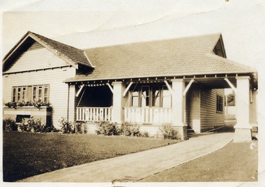
Digital photo, George L Coop, 688 Whitehorse Rd. Mont Albert c1950, c1950
This was the home of 3 generations of the Coop family: 1. Josephine and George Frank Coop (noted in Box Hill Rate Books for 1947-1954). 2. George Burton Coop (1906-1960) and his family. He was Assistant Chief Architect of Victoria in the Public Works Department (P.W.D.) George Burton Coop was born in c1906 in Williamstown, the son of Josephine Vistarini and George Frank Coop. He married Winifred Alice Trewartha in 1936 and they are listed in the electoral rolls at 688 Whitehorse Road in 1937. George died 3/4/1960, aged 54 years at Mont Albert. 3. George Burton and Alice Coop had 2 children: George Lister Coop - born St Georges Hospital, 8/10/1937 Alison - born c1945. The donor George Lister Coop informed that he initially attended Chatham State School because his first home was the Spanish Mission style flats at 346 Whitehorse Road, opposite Brenbeal Street, Balwyn. When his grandparents died, the family moved to 688 Whitehorse Road and he then attended Mont Albert Central School. The California bungalow style of housing was the dominant style of housing built in the interwar period through the northern parts of Surrey Hills and Mont Albert as formerly semi-rural land was subdivided for new housing. It was relatively inexpensive and affordable. In Australia the Californian bungalow drew upon elements that were popular across the United States from around 1910 to 1939. In Australia the style became popular from 1913. In Melbourne both timber and red brick were used as the main building material. Typically they are one or one and a half story houses and feature sloping roofs and eaves with unenclosed rafters and often a feature a dormer window (or an attic vent designed to look like one) over the main portion of the house. Decorative elements include wood shingles, part stucco rendered exteriors, brick, stone, rendered or a combination of these treatments to exterior chimneys and front porches supported by heavy timber, brick or stucco columns.A sepia photo taken at an angle from the street corner of the property. It is of a Californian bungalow with a driveway that extends through a carport, attached and roofed as part of the house, to the rear of the property. The veranda is accessed from under this covered area. The veranda and carport are supported by brick pillars and the veranda balustrades between are plain with an occasional wider feature panel. The front door is in shadow. There are rolled up striped canvas blinds on the veranda and at least 2 cane chairs. The main structure of the house is weatherboard with a terracotta tiled roof. There is a flower bed across the front of the house with an elevated brick flower box under the main window. There are no chimneys visible.californian bungalow, whitehorse road, george frank coop, (miss) josephine vistarini, (mrs) josephine coop, george burton coop, (miss) winifred trewartha, (mrs) winifred coop, george lister coop, alison coop -
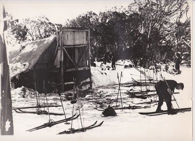 Falls Creek Historical Society
Photograph - At Wallace' s Hut
Wallace's Hut is the oldest surviving cattlemen's hut on the High Plains, built in 1889 by the three Wallace brothers - Arthur, William and Stewart. Their father David bought land at Kergunyah as well as grazing land on the banks of the Kiewa River, North East Victoria. Once the boys were old enough, the family followed the local squatters’ custom of taking their cattle up to the mountains for the spring and summer to fatten the mob, at the same time resting their home pastures. They decided to build a hut where they could shelter from the extreme mountain weather. The timber was cut from the forest about four hundred metres east of the hut, and the hearth stone was dragged in from Pretty Valley. The chimney had a base of rubble and above this iron sheeting on a timber frame. The slab walls were lined with hessian and later with tar-paper, and inside there was a bush table, sleeping platform and a rustic fire-side settle. The hut nestled among snow gums sheltered by a rocky outcrop. The names of the Wallace brothers were burnt into the tie-beams of the roof and at the back of the mantelpiece. The Wallace family’s lease expired in the late 1930s and the hut was bought by the State Electricity Commission to house staff on the High Plains and it became the first home of Toni and Skippy St. Elmo. The SEC covered the old shingles with iron, and later on the walls and chimney as well, and they added a lean-to. Wallace’s Hut is now owned by the Crown and maintained by Parks Victoria. It is on the Historic Buildings Register and is classified by the National Trust.This image is significant because it depicts an important heritage-listed structure and refuge for cattlemen and other travellers in Victoria's High Country.A black and white photograph of a skier outside of Wallace's Hut. Several sets of skis and poles are standing around and other skiers are in the background.wallace's hut, toni and skippy st. elmo, high country huts -
 Eltham District Historical Society Inc
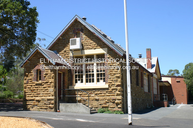
Photograph - Digital Photograph, Alan King, Eltham Primary School No. 209, Dalton Street, Eltham, 28 December 2007
... shingles on the roof. That building needed to be replaced after... shingles on the roof. That building needed to be replaced after ...This building is the earliest building remaining on site today. It was built in 1875 and was the second school building replacing the original 1856 building of stone walls with wooden shingles on the roof. That building needed to be replaced after the stone walls collapsed outwards. In August 1912 the school issued a requisition for remodelling of the school concerned with replacement of the existing windows with larger and wider windows to allow additional light into the school rooms and the erection of a wooden partition in the centre of the room. An extension to the building at rear and skylights in the roof were added in 1921. Only two low wooden stairs were originally provided to enter the porch. These were rebuilt by 1928. A steel mud grate was introduced 1930s/1940s and an infant shelter shed circa 1945. Covered under Heritage Overlay, Nillumbik Planning Scheme. Published: Nillumbik Now and Then / Marguerite Marshall 2008; photographs Alan King with Marguerite Marshall.; p49 Eltham Primary School at Dalton Street, bustling with hundreds of students, has changed dramatically since it began in July 1855.1 A reminder of its early days is the building in local sandstone with a slate roof. First head teacher was David G Clark who was officially in charge from June 1856 until 1889.2 This school was not the settlement’s first. That was the Church of England Little Eltham School, west of Diamond Creek in 1853 and closed in 1872. In 1855 David Clark and his sister Catherine, opened what was to become the present school, with eight students. The school operated elsewhere in a temporary slab building, also used for worship by the Wesleyans,3 which allowed the wind and rain easy access. As well as having to endure such Spartan conditions, the students paid one penny a week for the privilege. But in June 1856 the patrons objected to the conditions, and they and the Clarks wrote to the National Schools Board, asking for a suitable school. They asked for a grant to buy land for a school, and to appoint the Clarks. As a result, inspector Mr A B Orlebar visited the school. He found 33 children aged from four to 13 and noted, among other things: ‘There is no attempt at classification, and this is owing chiefly to the want of books, every child bringing with it any spelling or reading book he or she may find at home,4 and partly to the master and mistress having little idea of anything but individual instruction.’ Of Mr Clark, Mr Orlebar said: ‘I cannot pass him as coming up to the full standard of a probationer. He promises however to pursue a course….if the commissioners take him into their service.’ Of Catherine: ‘She makes a promise similar to that of her brother. Pupils were orderly and the school seemed well conducted. I cannot therefore hesitate to recommend them both personally as probationers.’ Later at a public meeting, Mr Orlebar pledged the commissioners would give £150 for a school, if this was matched by local residents. The meeting decided the commissioners would acquire two acres (0.8ha) for the school site. The building, constructed with local sandstone, was completed in December 1857, measuring 40 feet x 16 feet (12mx5m) and 10 feet (3m) high. It was divided into two rooms – one for the school and the other for teacher accommodation. So the Eltham school was born, in an area regarded as ‘one of the poorest in the colony’. Excerpts from inspectors’ reports in the following years, show that in some ways school has not changed that much since then: ‘Discipline only moderate. Too much chattering!’ (1873); ‘Several slates were cleaned with saliva applied by the hand! Damp rags would be much nicer.’(1891).5 In 1863 the Board of Education took over the school giving it its current name and number, Eltham Primary School No 209. Overcrowding has dogged the school over much of its history. In 1875 overcrowding spilled part of the school into the local courthouse. But that year the sandstone building, which is still standing, was built for 100 children, costing £553 and replacing the National School building. Now, this section, even following renovations, still bears part of its original graciousness, with lofty timber ceilings, tall vertical windows and original floors.This collection of almost 130 photos about places and people within the Shire of Nillumbik, an urban and rural municipality in Melbourne's north, contributes to an understanding of the history of the Shire. Published in 2008 immediately prior to the Black Saturday bushfires of February 7, 2009, it documents sites that were impacted, and in some cases destroyed by the fires. It includes photographs taken especially for the publication, creating a unique time capsule representing the Shire in the early 21st century. It remains the most recent comprehenesive publication devoted to the Shire's history connecting local residents to the past. nillumbik now and then (marshall-king) collection, dalton street, eltham primary school, state school no. 209 -
 Linton and District Historical Society Inc
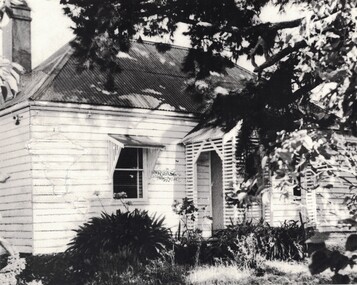
Photograph, 'Glenree' : home of the Rankin family
This house, understood to have been built around 1858/59, and demolished around 1990, was situated along what is now known as the Linton-Naringhil Road. It was the home of the Rankin family - John and Catherine Rankin, and later their son Ewen and his wife Anna Rankin. The last member of the Rankin family to live there (until 1974) was Marjorie Jackson, a granddaughter of John and Catherine. The original roof is thought to have been made of wooden shingles.Black and white photograph showing a weatherboard house which has a corrugated iron roof, two front windows and a small front porch. The windows have sunshades supported by timber brackets. A chimney can be seen above the rooftop at the rear of the house. The view of the house is partially obscured by branches of a tree. Date of the photograph is not known.glenree', rankin family, john rankin, ewen rankin, houses -
 Stawell Historical Society Inc
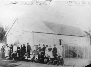
Photograph, Salvation Army Barracks in Main Street
Salvation Army Barracks Main Street Stawell. Weatherboard building part roof corrugated iron - remainder wooden shingles. Picket fence in foreground. Large group of people standing and seated on the footpath. The original Salvation Army Barracks is now at the rear of the present Citadel a red brick building. Stawell Corps was opened in the year 1884 in the month of May. The first meeting was conducted in a Church but afterwards the old market (area present Library) was secured for meetings. Captain Furbur and Lieutenant Quick were the first officers appointed. Photograph of a weatherboard building with a group of people standing and sitting in front of a picket fence. Part of the roof of the building is corrugated iron - remainder wooden shingles. The group of people standing and seated on the footpath, are a mixture of adults and children, some in uniforms, women in long dresses. Salvation army Barracks above the building door. Written in handwriting Stawell Barracks Mrs. R.J. Reeve.stawell religion