Showing 232 items
matching sandhurst parish
-
 Bendigo Historical Society Inc.
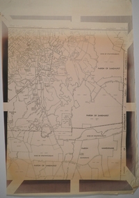
Map - CITY OF SANDHURST SHEET NO.6, 25/04/1882
... Map: City of Sandhurst sheet No. 6. Parish plan... Bendigo parish plan Sandhurst Map: City of Sandhurst sheet No. 6 ...Map: City of Sandhurst sheet No. 6. Parish planmap, bendigo, parish plan, sandhurst -
 Bendigo Historical Society Inc.
Map - CAMPBELL COLLECTION: BENDIGO AND DISTRICT MAPS
... Map. Parish of Sandhurst, Shire of Strathfieldsaye...MAP Bendigo city streets Map. Parish of Sandhurst, Shire ...Map. Parish of Sandhurst, Shire of Strathfieldsaye, Mandurang Parish, Junortoun.map, bendigo, city streets -
 Bendigo Historical Society Inc.
Map - JACK FLYNN COLLECTION: SANDHURST SHEET 6, January 1947
... Map: Parish of Sandhurst Sheet 6. County of Bendigo. Parish... Bendigo parish plan Sandhurst Sheet 6 By Authority J. J. Gourley ...Map: Parish of Sandhurst Sheet 6. County of Bendigo. Parish plan.By Authority J. J. Gourley, Government Printer, Melbourne. Drawn and Reproduced at the Dept, of Lands and Survey, Melbourne, Victoria.map, bendigo, parish plan, sandhurst sheet 6 -
 Bendigo Historical Society Inc.
Map - JACK FLYNN COLLECTION: SANDHURST SHEET 2, January 1947
... Map: Parish of Sandhurst Sheet 2, County of Bendigo. Parish... Bendigo parish plan Sandhurst Sheet 2 By Authority J. J. Gourley ...Map: Parish of Sandhurst Sheet 2, County of Bendigo. Parish plan.By Authority J. J. Gourley, Government Printer, Melbourne. Drawn and Reproduced at the Dept, of Lands and Survey, Melbourne, Victoria.map, bendigo, parish plan, sandhurst sheet 2 -
 Bendigo Historical Society Inc.
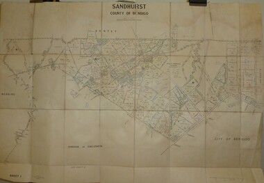
Map - JACK FLYNN COLLECTION: SANDHURST SHEET 1, January 1947
... Map: Parish of Sandhurst sheet 1, County of Bendigo. Parish... Bendigo parish plan Sandhurst Map: Parish of Sandhurst sheet 1 ...Map: Parish of Sandhurst sheet 1, County of Bendigo. Parish plan.map, bendigo, parish plan, sandhurst -
 Bendigo Historical Society Inc.
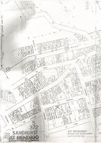
Map - LONG GULLY HISTORY GROUP COLLECTION: SANDHURST AT BENDIGO
... Copy of a map titled Sandhurst at Bendigo, Parish... at Bendigo, Parish of Sandhurst, County of Bendigo. Some ...Copy of a map titled Sandhurst at Bendigo, Parish of Sandhurst, County of Bendigo. Some of the street names are: Quick, Rae, Casley, Bell. Thomas, Victoria, Roeder and Prout Streets. Allotments have the date, size, measurements and names on them. Some are unreadable.bendigo, history, long gully history group, the long gully history group - sandhurst at bendigo -
 Bendigo Historical Society Inc.
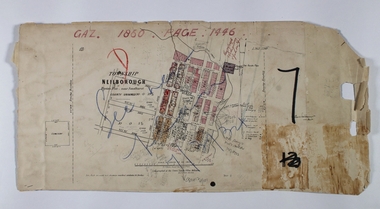
Map - NEILBOROUGH RAVENSWOOD, October 21 1859
... Map:Township of Neilborough, Elysian Flat, near Sandhurst... Map:Township of Neilborough, Elysian Flat, near Sandhurst,County ...Map:Township of Neilborough, Elysian Flat, near Sandhurst,County unnamed. Parish plan. Backing is a part of Ravenswood Township map.map, bendigo, neilborough, elysian flat, ravenswood -
 Bendigo Historical Society Inc.
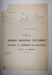
Map - BENDIGO IRRIGATION SETTLEMENT, 20/10/1908
... Map: Bendigo Irrigation Settlement, Parishes of Sandhurst... Settlement Map: Bendigo Irrigation Settlement, Parishes of Sandhurst ...Map: Bendigo Irrigation Settlement, Parishes of Sandhurst and Wellsford, County of Bendigo, Parish planmap, bendigo, irrigation settlement, bendigo irrigation settlement -
Bendigo Historical Society Inc.
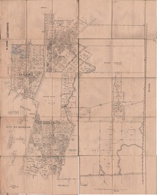
Map - CITY OF SANDHURST SHEET NO 4, 25/04/1882
... Map: City of sandhurst sheet No. 4. Parish plan ( number... Bendigo parish plan Sandhusrt Map: City of sandhurst sheet No. 4 ...Map: City of sandhurst sheet No. 4. Parish plan ( number 224 in Map Cupboard 1)map, bendigo, parish plan, sandhusrt -
Bendigo Historical Society Inc.
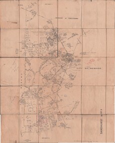
Map - CITY OF SANDHURST SHEET NO. 5, 18/04/1882
... Map: City of sandhurst sheet No. 5. Parish plan ( number... Bendigo parish plan Sandhusrt Map: City of sandhurst sheet No. 5 ...Map: City of sandhurst sheet No. 5. Parish plan ( number 223 in Map Cupboard 1)map, bendigo, parish plan, sandhusrt -
 Bendigo Historical Society Inc.
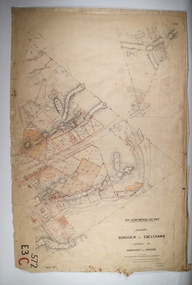
Map - BOROUGH OF EAGLEHAWK RE-SURVEY, 6/06/1883
... and Sandhurst, Sheet No. 1. Parish plan... and Sandhurst, Sheet No. 1. Parish plan Map BOROUGH OF EAGLEHAWK RE ...Map: Re-survey, Borough of Eaglhawk, Parishes of Nerring and Sandhurst, Sheet No. 1. Parish planmap, bendigo, re-survey, borough of eaglehawk, re-survey -
 Bendigo Historical Society Inc.
Map - CITY OF SANDHURST RESURVEY SHEET 1, 21/05/1881
... Map: City of Sandhurst resurvey sheet 1. Parish plan...MAP Bendigo parish plan Sandhurst Resurvey Map: City ...Map: City of Sandhurst resurvey sheet 1. Parish plan showing the Southeastern corner of the Municipalitymap, bendigo, parish plan, sandhurst, resurvey -
Bendigo Historical Society Inc.
Map - KANGAROO FLAT, 27/.01/1932
... Parish of Sandhurst...Map: Township of Kangaroo Flat, Parish of Sandhurst, County... Bendigo township Kangaroo Flat Parish of Sandhurst county ...Map: Township of Kangaroo Flat, Parish of Sandhurst, County of Bendigo ( number 148 in Map Cupboard 1)map, bendigo, township, kangaroo flat, parish of sandhurst, county of bendigo -
Bendigo Historical Society Inc.
Map - CITY OF SANDHURST RESURVEY SHEET 2, 23/05/1881
... Map City of sandhurst Resurvey, sheet 2. Parish plan... Bendigo parish plan Sandhurst Resurvey Map City of sandhurst ...Map City of sandhurst Resurvey, sheet 2. Parish plan ( number 231 in Map Cupboard 1)map, bendigo, parish plan, sandhurst resurvey -
Bendigo Historical Society Inc.
Map - KANGAROO FLAT SUBDIVISION, 26/11/1900
... Parish of Sandhurst...Map: Plan of Subdivision at Kangaroo flat, Parish... Bendigo parish plan Kangaroo Flat Parish of Sandhurst County ...Map: Plan of Subdivision at Kangaroo flat, Parish of Sandhurst, County of Bendigo ( number 149 in Map Cupboard 1)map, bendigo, parish plan, kangaroo flat, parish of sandhurst, county of bendigo -
Bendigo Historical Society Inc.
Map - BENDIGO IRRIGATION SETTLEMENT, 12/02/1908
... Map: Plan of Bendigo Irrigation Settlement, Parishes... Parishes of Sandhurst and Wellsford County of Bendigo Map: Plan ...Map: Plan of Bendigo Irrigation Settlement, Parishes of Sandhurst and Wellsford, County of Bendigo ( number 160 in Map Cupboard 1)map, bendigo, irrigation settlement, bendigo irrigation settlement, parishes of sandhurst and wellsford, county of bendigo -
 Bendigo Historical Society Inc.
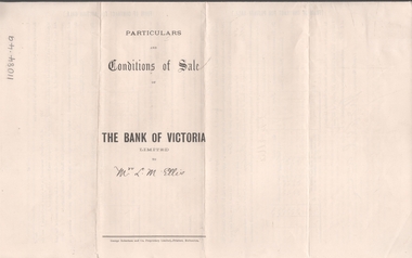
Legal record - ELLIS Edward Woodrow Tregenza - Land sale records, Watson, James & Rogers, Rogers Collection, 1907
... allotments 20, 22, 23 Parish of Sandhurst, County of Bendigo... of subdivision of crown allotments 20, 22, 23 Parish of Sandhurst, County ...In the early 1980s the firm of Watson, James & Rogers merged with the partnership of Every & Every and became the iconic “Rogers & Every” as known today. The firm is still located on Bull Street. https://rogersevery.com.au/about/* Particulars, conditions of sale and contract from bank of Victoria to Louisa Mary Ellis. 1907. * Plan of subdivision of crown allotments 20, 22, 23 Parish of Sandhurst, County of Bendigo * Agreement between Rupert Noyes Putnam of Williamson St. Bendigo and Edward Woodrow Tregenza Ellis of High St Bendigo for Crown allotments 18 and 19, Parish of Sandhurst County of bendigo.Signaturesrupert noyes putnam, land sales -
 Bendigo Historical Society Inc.
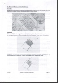
Document - History of 11 Mackenzie Street
... MacKenzie Street, Parish of Sandhurst, Bendigo from subdivision... of the ownership of the property at 11 MacKenzie Street, Parish ...Bendigo Historical Society moved into 11 Mackenzie Street, Bendigo in 2022. The BHS Collection has been installed in the building.Six-page history of the ownership of the property at 11 MacKenzie Street, Parish of Sandhurst, Bendigo from subdivision in 1894 to sale in 2021. through five owners. mackenzie street, historical society -
Bendigo Historical Society Inc.
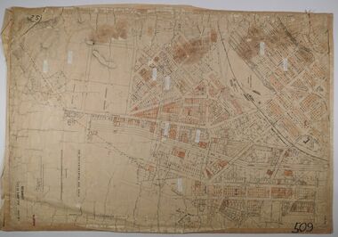
Map - BENDIGO, issued 1st January 1906
... and the Parish of Sandhurst. Issued by the Fire Underwriters Association... and the Parish of Sandhurst. Issued by the Fire Underwriters Association ...Map: Sketch map of Bendigo, including Eaglehawk and the Parish of Sandhurst. Issued by the Fire Underwriters Association of Victoria. Revised copy (number 317 in map cupboard 1)map, bendigo, city streets, map of bendigo, fire underwriters association of victoria -
 Bendigo Historical Society Inc.
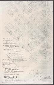
Document - RANDALL COLLECTION: BEAMENT FAMILY HOME SITE, 10 Jan 1877
... 117C, 40 Garsed Street, Bendigo.This was obtained from Parish... was obtained from Parish of Sandhurst, City of Bendigo, Sheet E ...Document, Beament Family Home Site, Allotment 11C, Section 117C, 40 Garsed Street, Bendigo.This was obtained from Parish of Sandhurst, City of Bendigo, Sheet E.bendigo, house, beament family -
 Bendigo Historical Society Inc.
Map - BENDIGO WEEROONA GASWORKS MAP/PLAN COLLECTION: CROWN ALLOTMENTS 13/14, 1942
... , Parish of Sandhurst. Shows site of Bendigo Gasworks. Prepared... allotments 13 and 14, Sec. E. City of Bendigo, Parish of Sandhurst ...Map: crown allotments 13 and 14, Sec. E. City of Bendigo, Parish of Sandhurst. Shows site of Bendigo Gasworks. Prepared by Garnel Gordon Birch Surveyor, 12.6.1942map, bendigo, gasworks, gas company, plans -
 Bendigo Historical Society Inc.
Document - MARKS COLLECTION: PARISH PLAN OF WHITE HILLS
... Lots White Hills Parish of Sandhurst. Scale is shown in chains... in Parish of Sandhurst (White Hills) Written on LH side of map town ...Sepia coloured map showing allotments in Parish of Sandhurst (White Hills) Written on LH side of map town and Suburban Lots White Hills Parish of Sandhurst. Scale is shown in chains. Surveyed by Horage Walker. Photo lithographed at the Department of Lands & Survey, Melbourne by J.Noone, Price 1/-. 6th. January 1865. Map shows Race Course Reserve at top of sheet, Municipal boundary is marked on LH side. Comments re vegetation throughout map. For example, poor soil timbered with Box scrub.on the back--Plan of Land White Hills Sandhurstbendigo, planning, white hills parish map, horage walker, j noone, department of lands and survey, -
 Bendigo Historical Society Inc.
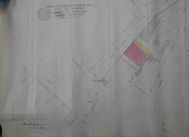
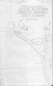
Photograph - DIAMOND HILL 1936, PLAN OF OCCUPATION
... parish of Sandhurst, County of Bendigo' Plan shows Post Office..., plan of occupation parish of Sandhurst, County of Bendigo' Plan ...Print of 'Application of J. Hattam, plan of occupation parish of Sandhurst, County of Bendigo' Plan shows Post Office site, large dam, 'formerly cultivated site near Post Office'. A un-named gully is marked.bendigo, mining, diamond hill -
 Bendigo Historical Society Inc.
Legal record - BERRY Harold Rupert Daniel - Covenant and Indemnity, Watson, James & Rogers, Rogers Collection, 1930
... , Section H, City of Bendigo Parish of Sandhurst, County of Bendigo... Parish of Sandhurst, County of Bendigo. Dated 17 April 1930 ...In the early 1980s the firm of Watson, James & Rogers merged with the partnership of Every & Every and became the iconic “Rogers & Every” as known today. The firm is still located on Bull Street. https://rogersevery.com.au/about/Covenant and Indemnity from Mrs A G and Mr M McKenzie to Harold Rupert Daniel Berry concerning Crown Allotment 392, Section H, City of Bendigo Parish of Sandhurst, County of Bendigo. Dated 17 April 1930.Signatureswatson james & rogers, bendigo, legal documents, covenant -
Bendigo Historical Society Inc.
Map - CAMPBELL COLLECTION: BENDIGO AND DISTRICT MAPS, 16-4-29
... Map. Kennington, Parishes of Sandhurst, Mandurang... Bendigo allotments W.J.Galbraith Map. Kennington, Parishes ...Map. Kennington, Parishes of Sandhurst, Mandurang and Strathfieldsaye. Scale 20 chains to 1 inch. Total area 2918 acres. Prepared in W.P.B. from A. and C.L. Plans by W.J.Galbraith, 16-4-29. (number 394 in map cupboard 1)W.J.Galbraithmap, bendigo, allotments -
 Bendigo Historical Society Inc.
Document - MCCOLL, RANKIN AND STANISTREET COLLECTION: DEBORAH EXTENDED GOLD MINING COMPANY NL, 1968
... Street, County of Bendigo, Parish of Sandhurst.... Street, County of Bendigo, Parish of Sandhurst. Document MCCOLL ...Document: McColl, Rankin and Stanistreet - Deborah Extended Gold Mining Company gold mining lease document. No. 11390, Vol. 334, Fol. 727, dated 21 Sept. 1967, - adjoins Fletcher Street, County of Bendigo, Parish of Sandhurst.organization, mining, deborah extended gold mining compan, mccoll, rankin and stanistreet, deborah extended gold mining company, gold mining, lease documents -
 Bendigo Historical Society Inc.
Document - CROWN ALLOTMENT 406A (PLAN) JOSS HOUSE
... of Bendigo. Parish of Sandhurst. County of Bendigo. Scale 1:500.... Parish of Sandhurst. County of Bendigo. Scale 1:500. (Copy ...Plan of Survey of part of Crown Allotment 406A Sec E. City of Bendigo. Parish of Sandhurst. County of Bendigo. Scale 1:500. (Copy of Original). As at 21 February 1979. This survey shows the location of the Joss House and the portion of land where it is located.plan, bendigo, joss house, crown allotment 406a (plan), joss house -
 Bendigo Historical Society Inc.
Document - MCCOLL, RANKIN AND STANISTREET COLLECTION: CENTRAL NELL GWYNNE, 5/10/1941
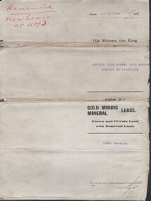
... district of Bendigo Parish of Sandhurst. No 11172 Bendigo Vol 327... of Bendigo Parish of Sandhurst. No 11172 Bendigo Vol 327 Fol 36016 ...Document. Paper Document containing an indenture detailing lease between His Majesty the King to Central Nell Gwynne Gold Mining Company No Liability. Included is a map of the mining district of Bendigo Parish of Sandhurst. No 11172 Bendigo Vol 327 Fol 36016.McColl, Rankin & Stanistreetorganization, business, central nell gwynne, mccoll, rankin & stanistreet, central nell gwynne, gold mining, lease -
 Bendigo Historical Society Inc.
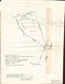
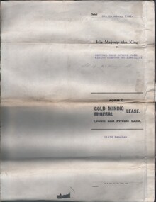
Document - MCCOLL, RANKIN AND STANISTREET COLLECTION: CENTRAL NELL GWYNNE - FORM D GOLD MINING LEASE 10981 BENDIGO, 5 Oct 1936
... of Bendigo Parish of Sandhurst City of Bendigo County of Bendigo... of Bendigo Parish of Sandhurst City of Bendigo County of Bendigo ...Document. Renewal New Lease no 11073 His Majesty the King to Central Nell Gwynne GMC N/L. 1 map no 10981 of Mining District of Bendigo Parish of Sandhurst City of Bendigo County of Bendigo. No 10981 Bendigo Vo 322 Fol 35594.McColl, Rankin & Stanistreetorganization, business, central nell gwynne, mccoll, rankin & stanistreet, cnetral nell gwynne, gold mining, lease -
 Bendigo Historical Society Inc.
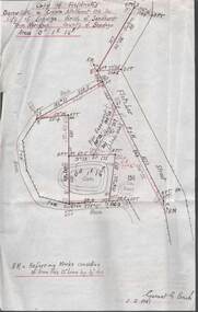
Plan - MCCOLL, RANKIN AND STANISTREET COLLECTION: PLAN OF SURVEY OF DAM SITE, 1941
... Allotment 198 Sec. City of Bendigo, Parish of Sandhurst. True... C, City of Bendigo, Parish of Sandhurst, County of Bendigo ...McColl Rankin & Stanistreet, Plan of Survey of Dam site, Part of Crown Allotment 98 Section C, City of Bendigo, Parish of Sandhurst, County of Bendigo. Signed by Garnet G Birch 1 Feb 1941. 33.5 x 43. Attached is a Copy of Field notes, Dam Site in Crown Allotment 198 Sec. City of Bendigo, Parish of Sandhurst. True Meridian, County of Bendigo, Area 0A 1R 16P. Signed Garnet G Birch, 1/2/1941. Drawn in red and black pen. 20.8 x 33. Both maps are for Deborah Extended Gold Mining Co. No Liabilityorganization, mining, deborah extended gold mining co nl, mccoll rankin & stanistreet, plan of survey of dam site