Showing 45 items matching "settlement scheme"
-
 Kiewa Valley Historical Society
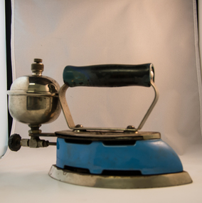
Iron Hand Kerosene, mid to late 1900s
The 1950's saw a revolution in small appliances for use in the average household. This hand held self heating(kerosene) iron was introduced as a time saving and more convenient iron for pressing clothes and other cloth fabrics. It replaced irons needing a separate fire source to heat the ironing plate. These irons continued to be in service, even when electricity was available in cities and larger rural towns (domestic electric steam irons were invented in 1938). This item was used before and during the electricity supplies available from the Kiewa Hydro Electricity Scheme. These irons remained in use within regional rural areas that had limited or unreliable electrical reticulation.In the 1950s and later the Kiewa Valley was still a relatively isolated region which was home to rural properties and small settlements. The availability of electricity and or the financial means to afford new types of electric hand irons ensured that older and sometimes less efficient ironing remained for an extended period covering the 1960s to 1970s. Kerosene products, such as this kerosene iron was a cheaper method for farm based domestic and other rural activities requiring a heat source. The use of kerosene as a heat/light source was able to be supplied in bulk and able to be used when floods severed vital roads into this region. The supply of electricity was in summer time subject to interruption from bush fire damaged wooden poles carrying the electrical cables. Self sufficiency by rural populations was the backbone of survival and the ability to store energy sources "on the farm" was a prerequisite of isolated regions, such as the Kiewa Valley, circa 1950s.This Coleman kerosene iron has a solid steel chrome plated(press) base with a painted (blue) wooden handle. The handle is stud fastened onto an oblong shaped rolled steel handle frame and screwed (two screws) onto the base plate. Both the heating plate and the top securing plate are shaped similar to a river boat. The main housing enclosing the heating element is enamel coated(blue in colour) steel and has a half hole for lighting the kerosene at the rear end. Behind the handle and protruding upwards is a stainless steel fully enclosed container (bowl shaped) for the main supply of kerosene to the burner or generator(enclosed within the main body of the iron. The bowl has an air valve and inlet for pressurised air intake (hand pump) On the bottom rear of the fuel bowl there is a screw regulated fuel pump. The fuel heated base plate provides the heat for this advertised "self heating iron(instant lighting). See KVHS 0347B- Instruction sheet; KVHS 0347C- Wrench; and KVHS 0347D Fuel can.Stamped on the base plate of the handle, front region "COLEMAN LAMP & STOVE CO." below this "WICHITA KAN" below this"TORONTO CAN". In the middle of the handle base and in larger print "COLEMAN Instant-Lite" At the rear location in large print "MODEL 4" in smaller print below "MADE IN U.S.A." below this "PAT#1718473"household appliances, alternative non electrical ironing appliances, domestic appliances, kerosene appliances -
 Kiewa Valley Historical Society
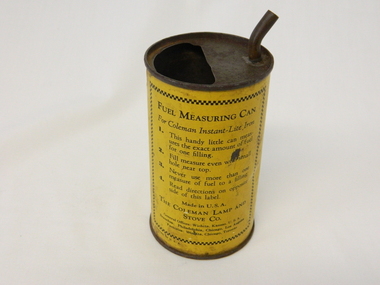
Can Fuel Measuring, circa 1950
The 1950's saw a revolution in small appliances for use in the average household. The hand held self heating(kerosene) iron for which this filling can was provided ,was introduced as a time saving and more convenient iron for pressing clothes and other cloth fabrics. It replaced irons needing an external fire source to heat the ironing plate. These irons continued to be in service, even when electricity was available in cities and larger rural towns. This item was used before and during the electricity supplies available from the Kiewa Hydro Electricity Scheme. These irons remained in use within regional rural areas that had limited or unreliable electrical reticulation and the ability to service them from this filling can was an essential part.n the 1950s and later the Kiewa Valley was still a relatively isolated region which was home to rural properties and small settlements. The availability of electricity and or the financial means to afford new types of electric hand irons ensured that older and sometimes less efficient ironing appliances remained for an extended period covering the 1960s to 1970s. Kerosene products, such as the kerosene self heating (KVHS 0347A) iron and this kerosene filling item, was a cheaper method for farm based domestic and other rural activities requiring a heat source. The use of kerosene as a heat/light source was able to be supplied in bulk and able to be used when floods severed vital roads into this region. The supply of electricity was in summer time subject to interruption from bush fire damaged wooden poles carrying the electrical cables. Self sufficiency by rural populations was the backbone of survival and the ability to store energy sources "on the farm" was a prerequisite of isolated regions, such as the Kiewa Valley, circa 1950s.This specially spout fitted can was provided with the Coleman self heating kerosene iron (see KVHS 0347A). On one side of the half enclosed top of the can there is a small spout(for poring the appropriate liquid into the egg shaped fount container) at the rear end of the hand iron. The can is made from tin. See KVHS 0347B- Instruction sheet; KVHS 0347C- Wrench.On one side of the can in black print on yellow background is "FUEL MEASURING CAN" underneath is "For Coleman Instant-Lite Iron" underneath are four numbered paragraphs detailing the use of this can. Below this is the name and places of manufacture. On the other side of the can is printed "BE SURE" with filling and maintenance instructionskerosene can, ironing, domestic appliances, household appliances -
 Orbost & District Historical Society
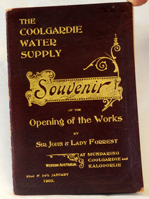
program, The Coolgardie Water Supply, 1903
This program belonged to Dr James Kerr. Conceived by Engineer-in-Chief C.Y. O’Connor and completed in 1903, the Coolgardie Goldfields Water Supply Scheme comprised a reservoir on the Helena River, eight steam-driven pumping stations and 566 kilometres of steel pipeline supplying 23,000 kilolitres of water daily to the arid goldfields of Western Australia. The project was officially opened by Sir John and Lady Forrest in January 1903. "Great pomp and ceremony heralded the arrival of water and the opening of the Scheme. Clean, fresh water could now be easily obtained in some of Australia's harshest country. However, this victory came at a great cost. The stress of the bold project was too much for O’Connor, who, after enduring endless criticism, took his life on 10 March 1902, before the Scheme was completed." - Western Australian Museum : The Coolgardie Goldfields Water Supply Scheme was an ambitious engineering feat because at the time water had never been lifted so high nor pumped so far (about 560 km). The Scheme, which pumps water from the better-watered coastal area, operates to this day. This item is associated with an historic event in the history of opening up arid areas of Australia to settlement. The item is associated with Dr James Kerr, the first doctor to settle in Orbost.A souvenir program from the opening of the works of the Coolgardie Water Supply. It has a maroon cover with gold print. Details include the date and place.coolgardie-water-supply western-australia-goldfields -
 Marysville & District Historical Society
Photograph (Item) - Black and white photograph, Fernshaw, c1900
An early black and white photograph taken at Fernshaw.An early black and white photograph taken at Fernshaw. Fernshaw was a rural township 63 km north-east of Melbourne and 10 km north-east of Healesville. Situated on the Watts River, near where a log had fallen making a convenient crossing, Fernshaw was settled in the 1860s. It provided good country for orchards and berry growing. The location was at the foot of Blacks Spur, with Mounts Juliet and Mondah rising on either side, providing spectacular scenery. There were nearby fern gullies giving rise to the name – ‘shaw’ is old English for thicket or wood. By 1875 Fernshaw had a post office (1865), two hotels, a school (1871) and stores. It was famed for its beauty, attracting tourists. In 1886 the Melbourne and Metropolitan Board of Works began work on the Watts River water catchment scheme – later to become Maroondah – and the Board obtained approval for the catchment country to be reserved and kept free of settlement. This required the removal of the Fernshaw township, which was completed by about 1890. The area was described in the 1903 Australian handbook:ARMSTRONG COLLECTION 42 STATION STREET/ SANDRINGHAM 3191/ TEL. (03) 9521 5442/ IAN M.L. ARMSTRONG OAMfernshaw, healesville, watts river, orchard, berry orchard, blacks spur, black spur, mount juliet, mount mondah, maroondah dam, victoria -
 Marysville & District Historical Society
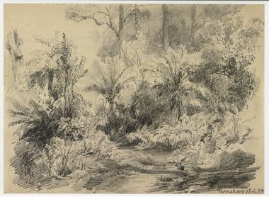
Artwork, other (Item) - Pencil Sketch, Louis Buvelot, Fernshaw 17.2.83, 1883
A copy of an early pencil sketch of Fernshaw in Victoria.A copy of an early pencil sketch of Fernshaw in Victoria by Louis Buvelot. Louis Buvelot ( 1814–1888), born Abram-Louis Buvelot, was a Swiss landscape painter who lived 17 years in Brazil and following 5 years back in Switzerland stayed 23 years in Australia, where he influenced the Heidelberg School of painters. Arriving in Melbourne in February 1865, after leaving the cold of Switzerland, which was impacting on his health, for the warmth of Australia, Buvelot was in business as a photographer in Bourke Street for a year but soon resumed his painting. He lived in Melbourne for a number of years before moving to Fitzroy. The National Gallery of Victoria purchased two of his paintings and he continued painting until his death in 1888. He was buried at the Boroondara Cemetery, where a large monument was erected in his memory. Fernshaw was a rural township 63 km northeast of Melbourne and 10 km northeast of Healesville. Situated on the Watts River, near where a log had fallen making a convenient crossing, Fernshaw was settled in the 1860s. It provided good country for orchards and berry growing. The location was at the foot of Blacks Spur, with Mounts Juliet and Mondah rising on either side, providing spectacular scenery. There were nearby fern gullies giving rise to the name – ‘shaw’ is old English for thicket or wood. By 1875 Fernshaw had a post office (1865), two hotels, a school (1871), and stores. It was famed for its beauty, attracting tourists. In 1886 the Melbourne and Metropolitan Board of Works began work on the Watts River water catchment scheme – later to become Maroondah – and the Board obtained approval for the catchment country to be reserved and kept free of settlement. This required the removal of the Fernshaw township, which was completed by about 1890.Fernshaw 17.2.83louis buvelot, fernshaw, victoria, national gallery of victoria, switzerland, boroondara cemetery, kew cemetery, artist -
 Marysville & District Historical Society
Painting (Item) - Oil painting, Isaac Whitehead, A spring morning near Fernshaw 1880, 1880
A copy of an early oil painting of Fernshaw in Victoria.A copy of an early oil painting of Fernshaw in Victoria by Isaac Whitehead. Isaac Whitehead (1819–1881) was an Irish-Australian artist who worked in watercolour and pastel. He was also a picture framer and art promoter. It is believed that Isaaz Whitehead emigrated to Australia with his family in either 1853 or 1858. Isaac Whitehead died at his home 50 Punt Road, Prahran, Melbourne, on 21 April 1881. Isaac Whitehead had established himself as the foremost picture framer in Melbourne by 1860, known for his highly ornate frames with floral decorations. Among the clients of his framing business were Louis Buvelot, Nicholas Chevalier, and Eugene von Guérard. In his own paintings, he painted a number of scenes of the forests of Gippsland, Victoria. His work focused on the rich landscapes with trees and ferns, with a high degree of botanical detail. His work won him two medals and his work was posthumously exhibited at 1884 Victorian Jubilee Exhibition, the 1886 London Colonial and Indian Exhibition, and the 1888 Melbourne Centennial Intercolonial Exhibition. Fernshaw was a rural township 63 km northeast of Melbourne and 10 km northeast of Healesville. Situated on the Watts River, near where a log had fallen making a convenient crossing, Fernshaw was settled in the 1860s. It provided good country for orchards and berry growing. The location was at the foot of Blacks Spur, with Mounts Juliet and Mondah rising on either side, providing spectacular scenery. There were nearby fern gullies giving rise to the name – ‘shaw’ is old English for thicket or wood. By 1875 Fernshaw had a post office (1865), two hotels, a school (1871), and stores. It was famed for its beauty, attracting tourists. In 1886 the Melbourne and Metropolitan Board of Works began work on the Watts River water catchment scheme – later to become Maroondah – and the Board obtained approval for the catchment country to be reserved and kept free of settlement. This required the removal of the Fernshaw township, which was completed by about 1890.isaac whitehead, fernshaw, victoria, louis buvelot, nicholas chevalier, eugene von guerard, gippsland, victorian jubilee exhibition, london colonial and indian exhibition, melbourne centennial intercolonial exhibition, watts river, healesville, blacks spur, mount juliet, mount mondah -
 Marysville & District Historical Society
Photograph (Item) - Black and white photograph, Fred Kruger, Scene on the Watts River near Fernshaw, Unknown
A copy of a black and white photograph on the Watts River near Fernshaw in Victoria.A copy of a black and white photograph on the Watts River near Fernshaw in Victoria taken by Fred Kruger. Fred Kruger (born Johan Friedrich Carl Kruger, 18 April 1831 – 15 February 1888) was a German-born photographer noted for his early photography of landscape and indigenous peoples in Victoria, Australia. Fernshaw was a rural township 63 km northeast of Melbourne and 10 km northeast of Healesville. Situated on the Watts River, near where a log had fallen making a convenient crossing, Fernshaw was settled in the 1860s. It provided good country for orchards and berry growing. The location was at the foot of Blacks Spur, with Mounts Juliet and Mondah rising on either side, providing spectacular scenery. There were nearby fern gullies giving rise to the name – ‘shaw’ is old English for thicket or wood. By 1875 Fernshaw had a post office (1865), two hotels, a school (1871), and stores. It was famed for its beauty, attracting tourists. In 1886 the Melbourne and Metropolitan Board of Works began work on the Watts River water catchment scheme – later to become Maroondah – and the Board obtained approval for the catchment country to be reserved and kept free of settlement. This required the removal of the Fernshaw township, which was completed by about 1890.fernshaw, watts river, victoria, fred kruger, photograph -
 Monbulk RSL Sub Branch
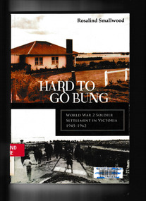
Book, Australian Scholarly, Hard to go bung : World War two soldiers settlement in Victoria 1945-1962, 2011
This book contains the story of Australia's most successful scheme for settling returned soldiers on their own farms. The book includes the recollections of many of the 6000 families who gained a livelihood on farms across the state.Index, notes, ill, maps, p.258.non-fictionThis book contains the story of Australia's most successful scheme for settling returned soldiers on their own farms. The book includes the recollections of many of the 6000 families who gained a livelihood on farms across the state.soldier settlements - victoria - history, land settlement - victoria - history -
 Yarra City Council
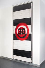
Painting - Public Art, Rule 30
Clinton Naina’s earliest memory is attending Collingwood football matches at Victoria Park with his father and uncles. His dad was an avid Collingwood supporter and Naina proudly wore his football colours. Lining up to enter the grounds at the big old black-and-white painted wooden doors gave Naina the feeling of entering into another world. 'Rule 30' is a comment on race relations in sport. The artwork is made from the original doors located at the front entrance of the Collingwood Football Club’s grounds at Victoria Park. When the club was refurbished the door was gifted to Naina by a friend—an ex-Collingwood football player—for use in his art practice. The work depicts a big red target painted on the existing Black and white stripes—Collingwood colours—of the door. Naina placed a fabric number ‘30’ on top of the target—created from material used for numbers on the back of players’ football vests. This represents the individuals who have been racially vilified while playing football over many years. The red represents the colour of human blood, while the Blak and white Collingwood colours already painted on the wood are a very fitting comment on race relations. The door itself becomes a potent metaphor for “overcoming barriers, making change, breaking down doors and moving forth into a new era of respect for people”. Rule 30 in the AFL was the first racial vilification code in Australian sport. It prohibited conduct between players, clubs and other AFL officials, which threatened, disparaged, vilified or insulted another person on the basis of that person’s race, religion, colour, descent or ethnic origin. In 2013, ‘Rule 30’ was amended to ‘Rule 35’ to combat other forms of discrimination including disability, appearance and sexuality.The number '30' cut out of fabric placed on top of a painted red target at the centre of an existing black and white wooden door.Accompanying labelracism, sport, football, afl -
 Robin Boyd Foundation
Slide, Robin Boyd, 1950
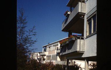
Penleigh Boyd, Robin and Patricia Boyd's son, writes “Prior to 1950 Robin, like most other amateur or hobby photographers, took black and white printed photographs. The oldest slides date from 1950 when Robin and Patricia travelled to Europe on Robin’s Robert Haddon Travelling Scholarship.” In 1948 Robin Boyd was awarded ‘joint first place’ in the Robert Haddon competition for his design of Mildura art gallery. The scholarship helped fund their first overseas trip. Robin and Patricia were passengers on the Greek ship “Cyrenia” departing in May 1950, passing through the Suez Canal and landing in Genoa five weeks later. For six months, they travelled extensively throughout Europe (predominantly driving themselves) - France, Italy, United Kingdom, Sweden, Denmark, Germany, Austria, Switzerland and Spain.Colour slide in a mount. Neubuhl Housing Settlement, (1930-1932), Zurich, Switzerland. (Architect: Swiss CIAM architects, Haefeli, Moser, Steiger, Roth, Artaria, Schmidt.)Zurich: 'Neubuhl' Housing Scheme / Haefeli, Moser, Steiger, Roth, Artaria, Schmidt / 1930-32 / Encircled 60 (All Handwritten)haddon travelling scholarship, haddon, robin boyd, slide -
 Wodonga & District Historical Society Inc
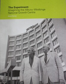
Booklet - THE EXPERIMENT : Imagining the Albury - Wodonga National Growth Centre, Bruce J Pennay, 2013
Introductory Abstract - "On its instigation in 1973, the Albury-Wodonga Growth Centre experiment was hailed as a novel and imaginative project. It was a "pilot scheme" that was expected to influence the urban settlement pattern in Australia. It was a "bold venture", a "brave attempt" to solve a longstanding problem. It involved three governments embarking on an "exciting adventure". This short book length catalogue essay (51 pages) provides an illustrated guide to the social history and visual arts exhibitions mounted for the 40th anniversary in 2013 of the inauguration of the Albury-Wodonga National Growth Centre experiment. The essay served as rationale and support for two council exhibitions at the Albury Library Museum and the Arts Space Wodonga in October and November 2013. The background story and the exhibitions are about place-making. They ask about the kind of place that has been made at Albury-Wodonga. How was it imagined, promoted, grown? They examine the experiment of developing Albury and Wodonga jointly and rapidly, and ask how that experiment relates to the place now and in the future. It assesses and gives a broad contextual account of the National Growth Centre experiment at Albury-Wodonga and traces important aspects of the story with emphasis on a local point of view. " Bruce Pennaynon-fictionIntroductory Abstract - "On its instigation in 1973, the Albury-Wodonga Growth Centre experiment was hailed as a novel and imaginative project. It was a "pilot scheme" that was expected to influence the urban settlement pattern in Australia. It was a "bold venture", a "brave attempt" to solve a longstanding problem. It involved three governments embarking on an "exciting adventure". This short book length catalogue essay (51 pages) provides an illustrated guide to the social history and visual arts exhibitions mounted for the 40th anniversary in 2013 of the inauguration of the Albury-Wodonga National Growth Centre experiment. The essay served as rationale and support for two council exhibitions at the Albury Library Museum and the Arts Space Wodonga in October and November 2013. The background story and the exhibitions are about place-making. They ask about the kind of place that has been made at Albury-Wodonga. How was it imagined, promoted, grown? They examine the experiment of developing Albury and Wodonga jointly and rapidly, and ask how that experiment relates to the place now and in the future. It assesses and gives a broad contextual account of the National Growth Centre experiment at Albury-Wodonga and traces important aspects of the story with emphasis on a local point of view. " Bruce Pennayalbury-wodonga, decentralisation, urban settlement australoa -
 Tatura Irrigation & Wartime Camps Museum
Book - Folder, Eschol Irrigation Settlement 1893 Book 1, 1985
... . A scheme for more agricultural settlements from irrigation areas..... A scheme for more agricultural settlements from irrigation areas ...Eschol Irrigation Settlement Prospectus, 1893. Original document photocopied by David Carrol, Tatura Research Station. A scheme for more agricultural settlements from irrigation areas.Black A5 folder with white printed label on front. Title on spine. Contains 20 plastic sleeves.inside cover: white label: Donor Tom Flanagan, Hogan Street Tatura 9.8.1985irrigation, document, eschol irrigation, david carrol, tatura research station -
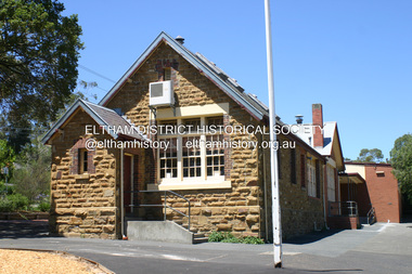 Eltham District Historical Society Inc
Photograph - Digital Photograph, Alan King, Eltham Primary School No. 209, Dalton Street, Eltham, 28 December 2007
This building is the earliest building remaining on site today. It was built in 1875 and was the second school building replacing the original 1856 building of stone walls with wooden shingles on the roof. That building needed to be replaced after the stone walls collapsed outwards. In August 1912 the school issued a requisition for remodelling of the school concerned with replacement of the existing windows with larger and wider windows to allow additional light into the school rooms and the erection of a wooden partition in the centre of the room. An extension to the building at rear and skylights in the roof were added in 1921. Only two low wooden stairs were originally provided to enter the porch. These were rebuilt by 1928. A steel mud grate was introduced 1930s/1940s and an infant shelter shed circa 1945. Covered under Heritage Overlay, Nillumbik Planning Scheme. Published: Nillumbik Now and Then / Marguerite Marshall 2008; photographs Alan King with Marguerite Marshall.; p49 Eltham Primary School at Dalton Street, bustling with hundreds of students, has changed dramatically since it began in July 1855.1 A reminder of its early days is the building in local sandstone with a slate roof. First head teacher was David G Clark who was officially in charge from June 1856 until 1889.2 This school was not the settlement’s first. That was the Church of England Little Eltham School, west of Diamond Creek in 1853 and closed in 1872. In 1855 David Clark and his sister Catherine, opened what was to become the present school, with eight students. The school operated elsewhere in a temporary slab building, also used for worship by the Wesleyans,3 which allowed the wind and rain easy access. As well as having to endure such Spartan conditions, the students paid one penny a week for the privilege. But in June 1856 the patrons objected to the conditions, and they and the Clarks wrote to the National Schools Board, asking for a suitable school. They asked for a grant to buy land for a school, and to appoint the Clarks. As a result, inspector Mr A B Orlebar visited the school. He found 33 children aged from four to 13 and noted, among other things: ‘There is no attempt at classification, and this is owing chiefly to the want of books, every child bringing with it any spelling or reading book he or she may find at home,4 and partly to the master and mistress having little idea of anything but individual instruction.’ Of Mr Clark, Mr Orlebar said: ‘I cannot pass him as coming up to the full standard of a probationer. He promises however to pursue a course….if the commissioners take him into their service.’ Of Catherine: ‘She makes a promise similar to that of her brother. Pupils were orderly and the school seemed well conducted. I cannot therefore hesitate to recommend them both personally as probationers.’ Later at a public meeting, Mr Orlebar pledged the commissioners would give £150 for a school, if this was matched by local residents. The meeting decided the commissioners would acquire two acres (0.8ha) for the school site. The building, constructed with local sandstone, was completed in December 1857, measuring 40 feet x 16 feet (12mx5m) and 10 feet (3m) high. It was divided into two rooms – one for the school and the other for teacher accommodation. So the Eltham school was born, in an area regarded as ‘one of the poorest in the colony’. Excerpts from inspectors’ reports in the following years, show that in some ways school has not changed that much since then: ‘Discipline only moderate. Too much chattering!’ (1873); ‘Several slates were cleaned with saliva applied by the hand! Damp rags would be much nicer.’(1891).5 In 1863 the Board of Education took over the school giving it its current name and number, Eltham Primary School No 209. Overcrowding has dogged the school over much of its history. In 1875 overcrowding spilled part of the school into the local courthouse. But that year the sandstone building, which is still standing, was built for 100 children, costing £553 and replacing the National School building. Now, this section, even following renovations, still bears part of its original graciousness, with lofty timber ceilings, tall vertical windows and original floors.This collection of almost 130 photos about places and people within the Shire of Nillumbik, an urban and rural municipality in Melbourne's north, contributes to an understanding of the history of the Shire. Published in 2008 immediately prior to the Black Saturday bushfires of February 7, 2009, it documents sites that were impacted, and in some cases destroyed by the fires. It includes photographs taken especially for the publication, creating a unique time capsule representing the Shire in the early 21st century. It remains the most recent comprehenesive publication devoted to the Shire's history connecting local residents to the past. nillumbik now and then (marshall-king) collection, dalton street, eltham primary school, state school no. 209 -
 Eltham District Historical Society Inc
Photograph - Digital Photograph, Alan King, Kangaroo Ground General Store, Eltham-Yarra Glen Road, 28 December 2007
The present store was built circa 1900 to replace another which had been destroyed by fire in 1898, which had replaced a predecessor on the opposite side of the road in 1865. The store was also used as a post office until early 2000s. The general store is historically significant because it has a long association with Kangaroo Ground and has been an important centre of community life for more than 120 years - Council meetings used to be conducted in the front room of the store at a time when Kangaroo Ground rivalled Eltham as the major centre of the Shire. The general store is historically and aesthetically significant as one of a group of three well preserved public buildings in the Kangaroo Ground hamlet and as a major heritage component of Kangaroo Ground which was one of the earliest settled areas of the Shire and which has the character of an English village rather than an Australian settlement. Covered under Heritage Overlay, Nillumbik Planning Scheme. Published: Nillumbik Now and Then / Marguerite Marshall 2008; photographs Alan King with Marguerite Marshall.; p77 Today the general store is an uncommon form of trade but the one at Kangaroo Ground continues a long tradition of friendliness and service. For more than 100 years it has been a centre of community life. In the settlement’s early days a previous general store, on the same site, was the meeting place for the Eltham District Road Board, precursor to the Eltham Shire Council. For years Kangaroo Ground rivalled Eltham as the shire’s major centre. It developed very differently from the rest of the shire as its rich soil attracted prosperous Presbyterian Scots who had large agricultural properties.1 The present store was built to replace another one, which had burnt down in 1898, after replacing a predecessor on the other side of the road in 1865. The store retains its outward character and its cellar, although inside it has changed considerably. It now includes a café and offers local produce, milk bar products, grocery items, gas and other fuel. Until early this century the store was also used as a post office. Kangaroo Ground’s first postmaster was Andrew Ross, who first operated from the school opposite, then from his hotel next to the present tennis court site. The first postmaster at this store was Edward Weller, followed in 1868 by James Anderson. At that time a mail coach ran three times a week between Eltham and Woods Point through Kangaroo Ground, Yarra Flats, Healesville, Fernshaw, Marysville and Matlock. Some early postmasters were Rodger, McLaughlin, Greenway and Burns.2 Burns was the only postmaster operating from the store. The others operated from Andrew Ross’s hotel. The mail service improved in 1892 when coaches ran from Melbourne to Queenstown (now known as St Andrews) and changed horses at Kangaroo Ground twice daily. The only telegraph office in the district at that time was at the Kangaroo Ground Post Office. Telegrams to outlying areas such as Queenstown and Kinglake had to be sent by hand. A local resident in the early 1900s often rode his pony to deliver telegrams and was paid one shilling a mile porterage. The store has also contributed to the lighter side of Kangaroo Ground life. During the years that Con Wraight owned the store, between 1906 and 1946, a new piano was needed for the Kangaroo Ground Hall, so monthly dances were held to raise money. When the piano was bought, a grand ball was held in the Kangaroo Ground Hall to celebrate the occasion and supper followed at Mr Wraight’s barn, cleaned especially for the occasion. Every New Year’s Eve, a Scottish piper would set off from between the store and the schoolhouse, playing his pipes, and march to Cameron’s Pigeon Bank homestead on the Kangaroo Ground-Warrandyte Road. Between 1914 and 1922, the store was a station for the Kangaroo Ground Bush Fire Brigade’s tanker. It consisted of a wooden barrel on a cart, fitted with a hand-pump, and stood on the side of the road outside the store. Joy Ness, who belonged to an early Kangaroo Ground family, moved here in 1940 and recalled her impressions of the store at that time: ‘It was a very dark shop stained in a dark colour and on the walls just below the ceiling hung hurricane lamps, ropes, kitchen utensils and other goods for sale. ‘Goods were weighed on a brass scale with weights, on which mothers also weighed their babies, because the nearest Infant Welfare Centre was at Greensborough. The bacon was cut with a hand slicer and later a pot-bellied stove warmed the store. Farmers and other locals used to gossip around it as they collected their daily mail. In those days the butter and cheese were kept in the cellar as no ice was delivered for cooling.’This collection of almost 130 photos about places and people within the Shire of Nillumbik, an urban and rural municipality in Melbourne's north, contributes to an understanding of the history of the Shire. Published in 2008 immediately prior to the Black Saturday bushfires of February 7, 2009, it documents sites that were impacted, and in some cases destroyed by the fires. It includes photographs taken especially for the publication, creating a unique time capsule representing the Shire in the early 21st century. It remains the most recent comprehenesive publication devoted to the Shire's history connecting local residents to the past. nillumbik now and then (marshall-king) collection, eltham-yarra glen road, kangaroo ground general store -
 Eltham District Historical Society Inc
Photograph - Digital Photograph, Marguerite Marshall, Hawthorn hedges, Eltham-Yarra Glen Road, Kangaroo Ground, 3 October 2006
Hawthorn hedges are important reminders of Kangaroo Ground's Scottish heritage. They are Registered on the Victorian Heritage Register. They are "historically significant because the planting of hawthorn hedges reflects the adoption of Eurorpean farming techniques by the Kangaroo Ground population in the period following settlement and because the grid pattern of paddocks that the Hawthorn hedges define is very different to today's farm landscapes." Covered under Heritage Overlay, Nillumbik Planning Scheme. Published: Nillumbik Now and Then / Marguerite Marshall 2008; photographs Alan King with Marguerite Marshall.; p21 Hawthorn hedges bordering Kangaroo Ground’s gently rolling farmlands are important reminders of its Scottish heritage and are rare so close to Melbourne.1 As early as the 1840s newly arrived farmers from Scotland planted hawthorn hedges around their properties, to protect crops from the numerous kangaroos and wallabies. Many of these hedges survive today. These farmers had the good fortune to settle some of the most fertile land available for cropping in the Colony of Victoria. At that time the black volcanic soil could sustain an amazing two crops a year. By the mid 1850s, 500 acres (202ha) of wheat were growing in Kangaroo Ground. But the crops were threatened by kangaroos, which were so plentiful, that Surveyor-General, Robert Hoddle, named the district Kangaroo Ground in 1838. As post-and-rail fences proved inadequate barriers for the bounding kangaroos, the Scots planted hawthorn hedgerows as they had done in Scotland. Some also used the hedges to net birds, presumably for the table. Interestingly the farmers in the bordering townships of Panton Hill and Christmas Hills, did not plant hawthorn hedges around their properties. Perhaps it was because by the time they settled in the 1860s and 1870s most of the wildlife had been gunned down by residents.2 The canny Scots planted the hedges on public land outside their own farms, as the hedgerows could spread to about five yards (five m) in width. With this impenetrable barrier Kangaroo Ground’s industrious farmers flourished to gain the economic power that saw the Shire of Eltham governed from Kangaroo Ground for 79 years (1858-1937). The Scots jealously guarded their land, so hard to get in Scotland. That is why they refused to release any of it ‘for local roads to follow easier grades as was the case in surrounding districts where roads generally followed ridgelines or streams’.3 Instead the roads were built in accordance with the magnetic bearings of their first survey in 1847 whether that suited the steep topography or not. This could force traffic to diverge when wet through Greensborough and Diamond Creek. Until 1921, the Eltham-Yarra Glen Road beside Wellers Restaurant, ‘dipped down into the upper reaches of Stony Creek’.4 Later some corners were compulsorily cut for the increasing motor traffic. As late as the 1960s, corners were cut to form sweeping curves above and alongside the Kangaroo Ground Cemetery and opposite the Emergency Operations Centre. In the latter case, the farmers – understanding their hedgerows as important heritage – insisted upon their reinstatement to conform to the altered road alignment. Kangaroo Ground’s ancient manna gums also point to the district’s history and to that of the hedgerows. The Aboriginal people had transformed the original forests into grasslands with the fires they lit to attract kangaroos, (which the Scots were to exclude by planting hedgerows). But the Wurundjeri hunters left the gums (Eucalyptus vimminalis cygnetensis), on the grasslands as ‘stalking trees’ to hunt kangaroos. The hawthorn hedges in Kangaroo Ground were neglected for around 60 years from about the middle of the 20th century. Bushfires had created gaps and the hedgerows were not trimmed. Then in late 2005, local historian Mick Woiwod, formed a group to lobby the Nillumbik Shire to restore the hedges, which could last for many centuries. Some hedges in parts of Britain date back to AD 800.5 Although the original Scottish farmers have gone, the hedges are a reminder of when they flourished in the district, which has changed little in 150 years.This collection of almost 130 photos about places and people within the Shire of Nillumbik, an urban and rural municipality in Melbourne's north, contributes to an understanding of the history of the Shire. Published in 2008 immediately prior to the Black Saturday bushfires of February 7, 2009, it documents sites that were impacted, and in some cases destroyed by the fires. It includes photographs taken especially for the publication, creating a unique time capsule representing the Shire in the early 21st century. It remains the most recent comprehenesive publication devoted to the Shire's history connecting local residents to the past. nillumbik now and then (marshall-king) collection, eltham-yarra glen road, hawthorn hedgerow, kangaroo ground