Showing 1330 items
matching south coast
-
 Flagstaff Hill Maritime Museum and Village
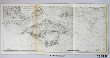
Document - Navigation Chart, Owers to Christchurch with Spithead and the Isle of Wight
... British Admiralty Navigation Chart - England - South Coast... - England - South Coast - Owers to Christchurch with Spithead ...British Admiralty Navigation Chart - England - South Coast - Owers to Christchurch with Spithead and the Isle of Wightwarrnambool, shipwrecked-coast, flagstaff-hill, flagstaff-hill-maritime-museum, maritime-museum, shipwreck-coast, flagstaff-hill-maritime-village, shipwrecked-artefact, navigation chart, british admiralty navigation chart, british admiralty, owers to christchurch -
 Phillip Island and District Historical Society Inc.
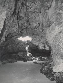
Photograph, Bryant West
... Photograph inside Forrest Caves South Coast Phillip Island... west Photograph inside Forrest Caves South Coast Phillip Island ...One of a collection of over 400 photographs in an album commenced in 1960 and presented to the Phillip Island & Westernport Historical Society by the Shire of Phillip IslandPhotograph inside Forrest Caves South Coast Phillip Island. Man inside looking out. local history, photography, photographs, coastline, caves, phillip island, forrest caves phillip island, john jenner, bryant west -
 Bendigo Historical Society Inc.
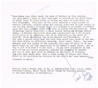
Document - BENDIGO - NATAL, 07/1972
... on the South Coast of Natal, South Africa.... about a query about the name of Bendigo on the South Coast ...Typed notes about a query about the name of Bendigo on the South Coast of Natal, South Africa.document, bendigo - natal, mr l bennetts, mr c c w johnn -
 Phillip Island and District Historical Society Inc.
Photograph, Bryant West
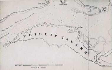
... Fort Dumaresq, track to beach and beginning of road to South... to beach and beginning of road to South coast. Photograph Bryant ...One of a collection of over 400 photographs in an album commenced in 1960 and presented to the Phillip Island & Westernport Historical Society by the Shire of Phillip IslandPhotograph of a Map of Phillip Island. The first to show Fort Dumaresq, track to beach and beginning of road to South coast. local history, photography, photographs, exploration, maritime, documents, maps, phillip island, john jenner, bryant west -
 Stawell Historical Society Inc
Painting, Will Rees, South Solitary Island NSW Coast, 1933
... South Solitary Island NSW Coast...South Solitary Island NSW Coast Will Rees 1933 South...South Solitary Island NSW Coast Will Rees 1933 South ...Framed Water Colour painting of island with cross on top. Sea with sailboat in foreground. 1933South Solitary Island NSW Coast Will Rees 1933 South Solitary Isl NSW -
 Phillip Island and District Historical Society Inc.
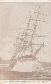
Photograph - Post Card, Early 1900's
... Sepia postcard of the "Speke" wrecked on rocks off south...-island-and-the-bass-coast One of a collection of photographs ...One of a collection of photographs purchased by the Society from Jack Day of Mornington.Sepia postcard of the "Speke" wrecked on rocks off south coast of Phillip Island on 22nd February 1906 with the lost of one life."The "Speke" on the rocks, Phillip Island, Victoria."the speke, wreck of the speke, phillip island, ship wrecks phillip island, jack day collection -
Lakes Entrance Historical Society
Book, Frank Allen MBE, A Big Lookout, 1982
... Monaro and South Coast from initial settlement until 1982... of life and times of the Southern Monaro and South Coast from ...An authorative account of life and times of the Southern Monaro and South Coast from initial settlement until 1982. Illustrated with photographs, Indexedsettlers, genealogy, industrial -
 Phillip Island and District Historical Society Inc.
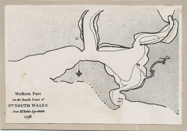
Photograph, Bryant West, 1798
... Coast of Nw. South Wales from GE Bass's Eye-sketch 1798"... As written on front of map - "Western Port on the South Coast of Nw ...One of a collection of over 400 photographs in an album commenced in 1960 and presented to the Phillip Island & Westernport Historical Society by the Shire of Phillip IslandPhotograph of the First Map of Phillip Island ever drawn. An eye sketch by Bass.As written on front of map - "Western Port on the South Coast of Nw. South Wales from GE Bass's Eye-sketch 1798"local history, photography, photographs, exploration, maritime, documents, maps, george bass, phillip island, bryant west, john jenner -
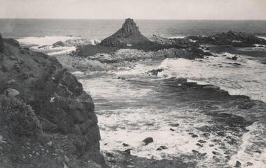
 Phillip Island and District Historical Society Inc.
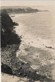
Photograph, Bryant West
... coastline - south coast... coast south coast cliffs south coast phillip island john jenner ...One of a collection of over 400 photographs in an album commenced in 1960 and presented to the Phillip Island & Westernport Historical Society by the Shire of Phillip IslandPhotograph from cliff top of rocky south coastline looking easterlylocal history, photography, photographs, coastline - south coast, south coast, cliffs, south coast phillip island, john jenner, bryant west -
 Orbost & District Historical Society
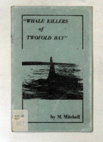
books, Whale Killers of Twofold Bay, circa 1960
... coast of New South Wales.... coast of New South Wales. Twofold-Bay whaling Mitchell-Mary ...Author, Mary Mitchell was the daughter of Charles Wellings early resident of Eden. Charles took many of the early photos of Eden while his brother, Henry, did the research on the Imlay Bros (very early settlers of Orbost) and early Twofold Bay settlers. Mary Wellings married Roy Mitchell of Lower Towamba. In Eden there are streets and a park named for both families.These books record the history of the whaling industry on the south coast of New South Wales.Two copies of a small thin ten page booklet with blue laminated covers. It has black print and a black photo of a whale tail on the front cover.It was written by Mary Mitchell. The book relates the history of whaling at Twofold Bay on the south coast of New South Wales.2116.1 - has a library sticker on the front cove - bottom left hand cornertwofold-bay whaling mitchell-mary welliings -
 Lakes Entrance Historical Society
Photograph, 1975
... Colour photograph of the Hippolite Rocks on the south east... of the Hippolite Rocks on the south east coast of Tasmania, taken from ...Also three same size similar photographsColour photograph of the Hippolite Rocks on the south east coast of Tasmania, taken from the fishing boat Minawie. Tasmaniafishing industry, boats and boating, topography, ocean -
 Peterborough History Group
Document - Age of exploration
... Information about the French exploration of the south coast... Information about the French exploration of the south coast ...Information about the French exploration of the south coast of AustraliaConsolidation of information about the French exploration of the south coast, including the Peterborough area.Newspaper cutting, photocopied informationbaudin, matthew flinders, peterborough history, peterborough 3270 -
 Phillip Island and District Historical Society Inc.
Photographs, 1998
... south coast phillip island... of Phillip Island. the nobbies phillip island south coast phillip ...A group of photographs donated by Henrietta Da Costa, Telopa, NSW - in order to retain local history of Phillip Island.Eleven coloured photographs of The Nobbies area and coastline and Ventnor farmland.the nobbies phillip island, south coast phillip island, the blowhole phillip island, farmland ventnor phillip island, henrietta da costa -
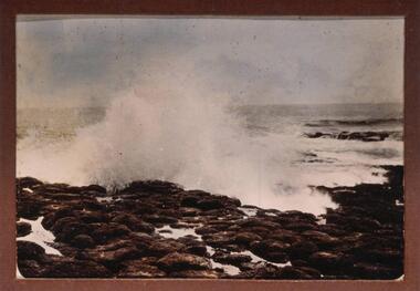
 Phillip Island and District Historical Society Inc.
Photograph, Early 20th Century
... south coast phillip island... donated by Ralph Correy. rock formations south coast phillip ...One of a collection of 13 photographs donated by Ralph Correy.Black & White photograph of waves breaking over a rock platform near The Nobbies.rock formations, south coast phillip island, breaking waves, phillip island coastline, ralph correy -
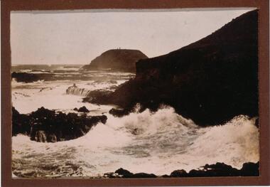 Phillip Island and District Historical Society Inc.
Photograph, Early 20th Century
... south coast phillip island... south coast phillip island ralph correy Black & White photograph ...One of a collection of 13 photographs donated by Ralph Correy.Black & White photograph of breaking waves over rocks looking towards The Nobbies. Two little specks on top of The Nobbies are the Lighthouse and Beacon.the nobbies phillip island, breaking waves, south coast phillip island, ralph correy -
 Phillip Island and District Historical Society Inc.
Photograph, Early 20th Century
... south coast phillip island... donated by Ralph Correy. breaking waves south coast phillip island ...One of a collection of 13 photographs donated by Ralph Correy.Black & White photograph of waves breaking over the rocks - probably near The Nobbies.breaking waves, south coast phillip island, phillip island coastline, ralph correy -
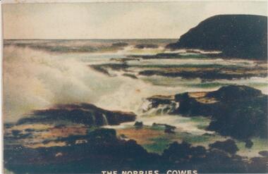 Phillip Island and District Historical Society Inc.
Photograph, Early 20th Century
... south coast phillip island... phillip island south coast phillip island coastline phillip island ...One of a collection of photographs donated by Bruce BennettColoured copy of a postcard. Rock platform with breakers and Nobbies at top right."The Nobbies - Cowes"the nobbies phillip island, rock formation phillip island, south coast phillip island, coastline phillip island, bruce bennett -
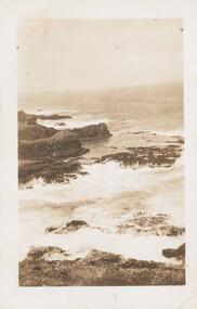 Phillip Island and District Historical Society Inc.
Photograph, Early 20th Century
... south coast phillip island... donated by F. Winn phillip island coastline south coast phillip ...One of a collection of 9 photographs donated by F. WinnSepia photograph of the South Coastline of Phillip Island with waves crashing on the rocks.phillip island coastline, south coast phillip island, coastal, f winn -
 Phillip Island and District Historical Society Inc.
Photograph, Bryant West
... south coast... formation - pyramid rock coastline south coast pyramid rock john ...One of a collection of over 400 photographs in an album commenced in 1960 and presented to the Phillip Island & Westernport Historical Society by the Shire of Phillip IslandPhotograph of Pyramid Rock looking south from cliff toplocal history, photography, photographs, coastline - rock formation - pyramid rock, coastline, south coast, pyramid rock, john jenner, bryant west -
National Vietnam Veterans Museum (NVVM)
Journal, Chao
... VVAA – Far South Coast & Monaro Sub-Branch... – Periodicals VVAA – Far South Coast & Monaro Sub-Branch Chao Journal ...veterans – australia – periodicals, vvaa – far south coast & monaro sub-branch -
Victorian Aboriginal Corporation for Languages
Book, Chris Illert, Early ancestors of Illawarra's Wadi-Wadi people. Part 1., The unacknowledged sources of traditional stories in C. W. Peck's book 'Australian legends, tales handed down from the remotest times--' (publ. 1925 and 1933), 2003
... South Coast NSW... South Coast NSW Cooma Maps, b&w photographs, b&w illustrations ...Includes stories about people and the languages, word lists,pronunciation and sources of stories.Maps, b&w photographs, b&w illustrations, word lists, newspaper articleswadi wadi, wulungulu, gundungara, korewal, south coast nsw, cooma -
Victorian Aboriginal Corporation for Languages
Book, Leon Costermans, Trees of Victoria and adjoining areas, 1994
... South Coast NSW... Street Brunswick melbourne trees East Gippsland South Coast NSW ...Format features leaf identification, map of location, seeds and bark etc., in black and white drawings.Colour photographs, illustrations, mapstrees, east gippsland, south coast nsw, mallee -
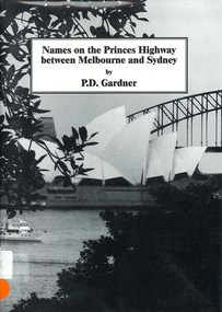 Victorian Aboriginal Corporation for Languages
Book, P D Gardner, Names on the Princes Highway between Melbourne and Sydney : their origins, meanings and history, 2000
... South Coast NSW... Street Brunswick melbourne Dandenong Genoa South Coast NSW Yarra ...Place name list in a specific area. Giving descriptions and meanings.Maps, b&w illustrationsdandenong, genoa, south coast nsw, yarra river, moruya, kiama, captain cook, east gippsland, rosedale -
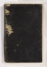 Queenscliffe Maritime Museum
Document - Diary of John Clarke 1850 to 1883, John Clarke, Personal diary of John Clarke, 1850 to 1883
... South coast... to Port Phillip Ship Wrecks South coast A small leather bound ...The wreck site identified as the Columbine, a two masted brig built in 1839 in Aberdeen, Scotland and wrecked on the 1st April 1854 at Ocean Grove, Victoria, was formally reported to Heritage Victoria as located on the 15th January 2003 by Peter Ferrier and Don Love. As the site is over 75 years old it is automatically protected under the Commonwealth Historic Shipwrecks Act 1976. This diary is important as it outlines the eye witness account of the last moments of the Barque Columbine which is primarily of historic, technical, social and archaeological significance internationally and to the State of Victoria. It is a unique original account of that episode in early migrant history of Victoria and of Australia.A small leather bound black diary containing entries by John Clarke from 1843 to 1883, recording aspects of his life in Australia from the wreck of the Colombine as a child [approx 13 y.o.a.] to his experiences working in the gold fields and around the Geelong area. The diary is extensively damaged.john clarke, barque colombine, approaches to port phillip, ship wrecks, south coast -
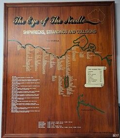 Flagstaff Hill Maritime Museum and Village
Artwork, other - Shipwreck Board, The Eye of the Needle: Shipwrecks, Stranding's and Collisions, ca 2002
... South Coast of Victoria... South Coast of Victoria Cape Otway Victorian Lighthouse King ...The Shipwreck Board is a feature of Flagstaff Hill Maritime Museum and Village/ its subject is explained briefly in the Museum's handbook, The Flagstaff Hill Navigator, published in 2008: - "Known as the ‘Eye of the Needle’ the treacherous entrance to Bass Strait is littered with the wreckage of large international vessels and smaller sail and steam craft used in coastal trade. The vessels bringing emigrants and cargo to Australia found the western entrance to Bass Strait the most dangerous part of their voyage. They had to thread their way between the southern point of Victoria (Cape Otway) and the northern point of King Island, a stretch of water less than 90 km wide. Many smaller coastal vessels were lost at Portland, Port Fairy, Warrnambool and Apollo Bay which are not safe harbours in certain weather conditions. "The Shipwreck Board shows shipwrecks, strandings and collisions which occurred in this area up to the year 1940. Wrecks are identified by a yellow light and collisions/strandings by a green light. These lights also identify the decade the wreck occurred by lighting up when the relevant decade button is pushed. Interesting happenings of the decades are listed next to the buttons." The Shipwreck Board's demonstration of The Eye of the Needle is an interactive visual display that helps teach the perils and dangers faced by early settlers in Victoria. It tells of the vast number of lives lost. It lists the names of many infamous shipwrecks and significant events.The large stained and lacquered timber board is mounted in a timber, frame. It is painted with a small sketch of Australia, and an enlarged outline of the southern coast of Victoria, King Island and the North West coast of Tasmania. The interactive display highlights the shipwrecks, standings and collisions suffered by many vessels as they navigated the 'Eye of the Needle', a narrow stretch of Bass Strait. The locations of the Lighthouses are pinpointed. Lists of groups of ships are below the coastlines. A painted scroll shows eight major shipwrecks with the number of lives lost for each one. A table shows historical facts associated with the decades from pre-1830 to 1940. A system of coloured lights compares the decades with the vessels that suffered damage. The board was created by artist and signwriter, Alex O'Flynn Computer Signs.flagstaff hill, maritime museum, maritime village, shipwreck coast, eye of the needle, shipwreck locations, bass strait, basses strait, king island, north west tasmania, south coast of victoria, cape otway, victorian lighthouse, king island lighthouse, strandings, coastal tracers, emigrant ships, sea trade, 1930s-1940s, shipwreck board, the eye of the needle, collosions, alex o'flynn, alex o’flynn computer signs, shipwrecks of western victoria -
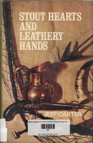 Narre Warren and District Family History Group
Book, Jeff Carter, Stout hearts and leathery hands, 1968
... Foxground South Coast NSW...Foxground South Coast NSW country living Here is a robust ...Here is a robust picture of an Australia which few people know. Jeff Carter writes in his usual forthright and picturesque style about the people he met when he turned his back on the cities the true individualists such as the maker of flint-lock muskets, the bird-imitator, the builder of dry stone walls. He tells also of how he and his family took over an overgrown farm in the hills, and of their fashioning of a new and richly satisfying way of life far from traffic-lights and smog. It is a full-flavoured book of the open air, of the sturdiness and self-reliance of those to whom achievements mean more than possessions. And if, in reading it, you should wish that you could live in the same way, Jeff Carter gives some tantalizing advice on how you can build a new life for yourself in company with those of STOUT HEARTS AND LEATHERY HANDS. (cover)non-fictionHere is a robust picture of an Australia which few people know. Jeff Carter writes in his usual forthright and picturesque style about the people he met when he turned his back on the cities the true individualists such as the maker of flint-lock muskets, the bird-imitator, the builder of dry stone walls. He tells also of how he and his family took over an overgrown farm in the hills, and of their fashioning of a new and richly satisfying way of life far from traffic-lights and smog. It is a full-flavoured book of the open air, of the sturdiness and self-reliance of those to whom achievements mean more than possessions. And if, in reading it, you should wish that you could live in the same way, Jeff Carter gives some tantalizing advice on how you can build a new life for yourself in company with those of STOUT HEARTS AND LEATHERY HANDS. (cover)foxground south coast nsw, country living -
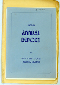 Orbost & District Historical Society
folder of documents, 1985 -1991
... of Orbost & District Tourist Association and of South East Coast... Tourist Association and of South East Coast Tourism Limited ...These documents were compiled by the Slab Hut (Orbost Visitor Information Centre) Committee.These documents are a useful reference item.A manila folder of ten documents. It contains reports of Orbost & District Tourist Association and of South East Coast Tourism Limited.tourism-orbost slab-hut -
Lakes Entrance Historical Society
Book, Harvey, Peter, Clonmel Disaster to Discovery, 1999
... on the South Gippsland coast in January 1841, at what became known... A study of the wooden paddle steamer Clonmel, wrecked on the South ...A study of the wooden paddle steamer Clonmel, wrecked on the South Gippsland coast in January 1841, at what became known as Port Albert.ships and shipping, settlers, historic sites, conservation -
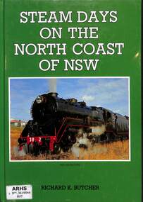 Victorian Railway History Library
Book, Butcher, Richard. K, Steam Days on the North Coast of NSW, 1990
... Locomotives -- New South Wales -- North Coast -- History... Prahran Locomotives -- New South Wales -- North Coast -- History ...A history of the transition from steam to diesel on the North Coast railway to Casino in NSW.ill, maps, p80.non-fictionA history of the transition from steam to diesel on the North Coast railway to Casino in NSW.locomotives -- new south wales -- north coast -- history, railroads -- new south wales -- north coast -- history -
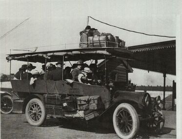 Torquay and District Historical Society
Copy Photo, Torquay History Exhibition 2016, Produced for exhibition 2016
... to Torquay, or perhaps further along the south coast.... returned from a trip to Torquay, or perhaps further along the south ...Photo shows Edward Molyneux's motorised drag with a full complement of tourists, embarking for, or just returned from a trip to Torquay, or perhaps further along the south coast.The beginning of motorised tourism on the Surf Coast.Black and white photo