Showing 36 items matching "south esk"
-
 Kew Historical Society Inc
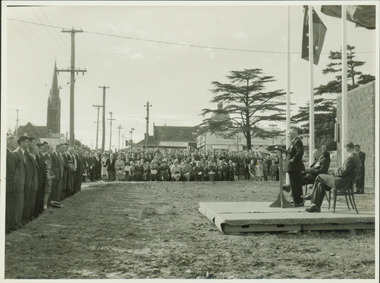
Photograph - Anzac Day Service in front of the Kew City Hall and World War II Memorial, 1960
... to Charles Street and the lawns of South Esk. The speaker would... to Charles Street and the lawns of South Esk. The speaker would ...The Kew City Hall, designed by the architect Harold Bartlett of Leith & Bartlett, was opened by The Premier The Hon HE Bolte on 23rd April 1960. At the time of the opening, Cr Ferguson was Mayor of Kew. Monochrome photograph of the annual Anzac Day service on the front lawn of the newly opened Kew City Hall in 1960. The Town Hall faced Cotham Road in front of which are standing returned soldiers. Invited seated and standing guests have their backs to Charles Street and the lawns of South Esk. The speaker would appear to be the Deputy Premier, and local Member for Kew Arthur Rylah MP. Behind the Official Party [but unseen] are the two Memorial plaques by George Henry Allen (1900–72). In the distance are the Kew Presbyterian Church and the Sacred Heart Church. Cr Ferguson / Anzac Day Service 1960kew city hall, city halls -- victoria, cr hugh ferguson, kew town hall, kew (vic.) -- civic buildings, anzac day services -- kew (vic.) -
 Kew Historical Society Inc
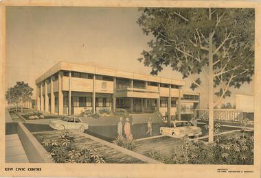
Drawing, AK Lines, Macfarlane & Marshall, Kew Civic Centre, c.1970
... renamed South Esk). Whereas the entrance to the Civic Hall...) on the site of the former mansion Ordsall (later renamed South Esk ...The Kew Civic Centre (A K Lines, MacFarlane & Marshall, 1972) was built next to the Kew Civic Hall (A C Leith & Bartlett, 1960) on the site of the former mansion Ordsall (later renamed South Esk). Whereas the entrance to the Civic Hall was positioned off Civic Drive, the main entrance to the Civic Centre faced Cotham Road, as shown in the undated perspective drawing of the proposed building. The Civic Hall was used for public functions and performances, while the Civic Centre was used for civic offices. It also contained the Council Chamber. The building opened in 1972, following the relocation of the councillors and council officers from the former Town Hall in Walpole Street (now a Woolworth's supermarket). Following the amalgamation of the former City of Kew into the City of Boroondara in 1994, the Civic Centre was sold to Trinity Grammar School. The exterior of the Centre has been modified by Trinity Grammar.A report for Heritage Victoria (date) describes how two architectural firms dominated the designs for new civic buildings in Victoria during the post war period. The report claims that: "An interesting sub-theme in the erection of post-war municipal offices in Victoria is that a considerable proportion were designed by the same three or four Melbourne-based architectural firms, who established themselves as the leading specialists in this type of work. The two most prolific firms in this regard were A K Lines, MacFarlane & Marshall, and A C Leith & Bartlett; both, in fact, had made names for themselves as designers of local government offices prior to the Second World War. Lines' office, for example had designed the Eltham Shire Offices in 1941, while Leith's firm had been responsible for the celebrated Heidelberg Town Hall in 1937). Both practices parleyed this early experience into a lucrative post-war career, designing numerous municipals offices well into the 1970s." (Survey of Post-War Built Heritage in Victoria, Built Heritage Pty Ltd, 2010.) The perspective drawing importantly captures the original design and function of the exterior of the building and its public entrance.Hand-coloured perspective sketch of the new Kew Civic Centre, completed in 1972 to designs by A K Lines, MacFarlane & Marshall; and located on the corner of Charles Street and Cotham Road, Kew. The sketch represents the front elevation of the building and its relation to the preexisting Kew Civic Hall at right. The three storey building features strong vertical concrete buttresses that extend across the three levels. KEW CIVIC CENTRE / A K LINES, MACFARLANE & MARSHALLkew civic centre, a.k. lines, macfarlane & marshall, architectural drawings, civic buildings -- kew (vic.), town hall -- kew (vic) -
 Kew Historical Society Inc
Plan - Subdivision Plan, J R Mathers & McMillan, Glenarbor Estate, 1934
... the vote, instead opting for the compulsory acquisition of South... for the compulsory acquisition of South Esk on the corner of Charles Street ...Pru Sanderson, in her groundbreaking ‘City of Kew Urban Conservation Study : Volume 2 - Development History’ (1988), summarised the periods of urban development and subdivisions of land in Kew. The periods that she identified included 1845-1880, 1880-1893, 1893-1921, 1921-1933, 1933-1943, and Post-War Development. These periods were selected as they represented periods of rapid growth or decline in urban development. An obvious starting point for Sanderson’s groupings involved population growth and the associated economic cycles. These cycles also highlighted urban expansion onto land that was predominantly rural, although in other cases it represented the decline and breakup of large estates. A number of the plans in the Kew Historical Society’s collection can also be found in other collections, such as those of the State Library of Victoria and the Boroondara Library Service. A number are however unique to the collection.The Kew Historical Society collection includes almost 100 subdivision plans pertaining to suburbs of the City of Melbourne. Most of these are of Kew, Kew East or Studley Park, although a smaller number are plans of Camberwell, Deepdene, Balwyn and Hawthorn. It is believed that the majority of the plans were gifted to the Society by persons connected with the real estate firm - J. R. Mathers and McMillan, 136 Cotham Road, Kew. The Plans in the collection are rarely in pristine form, being working plans on which the agent would write notes and record lots sold and the prices of these. The subdivision plans are historically significant examples of the growth of urban Melbourne from the beginning of the 20th Century up until the 1980s. A number of the plans are double-sided and often include a photograph on the reverse. A number of the latter are by noted photographers such as J.E. Barnes.The little-known Glenarbor Estate comprised 23 allotments bordering Wellington and Denmark Streets and Fenton Avenue. The auction of the allotments in the Estate was held in the Kew Recreation Hall. The purported advantages to Kew are identified on the plan, such as the close proximity of the entrance to the Kew Railway Station and access to shops in Denmark Street. Due to its location, the subdivision was pitched at commercial as well as residential purchasers. The Estate was to cause a crisis in the Kew Council as a majority of councillors voted on 29 May to acquire the entire Estate as the location of a new Town Hall. The Estate was said to be valued at £50,000. A later meeting was to rescind the vote, instead opting for the compulsory acquisition of South Esk on the corner of Charles Street and Cotham Road. That acquisition was to be overturned by the State Government. The debate about the purchase of the Glenarbor Estate by Council coincided with the decision to widen High Street on the South side between Cotham Road and the Junction."D"subdivision plans - kew, glenarbor estate, wellington street, denmark street -
 Port Fairy Historical Society Museum and Archives
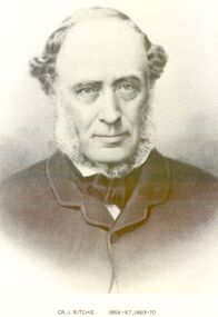
Photograph, Cr J Ritchie Shire of Belfast President1866-67 1869-70
... been 9 months on the outward journey. he took up land at South... journey. he took up land at South Esk and remained there for 6 ...Cr J Ritchie came from Scotland at Hobart in 1833 having been 9 months on the outward journey. he took up land at South Esk and remained there for 6 years.later on advice of the Henry brothers he came to Victoria and after a preliminary inspection of the land charted the brig “William” and with all of his possessions, including 2000 sheep and two servants he arrived in Portland Bay in January 1840 and as he already held a squatting licence No 230 became a settler in the district. he moved along the coast toward Goose Lagoon but due to a drought the water had dried up and forced him to move further eastward to the Upeer Hopkins but the lack of any but brackish water he was forced to return to Aringa. Aringa comprised of 26,000 acres between the Shaw and Moyne Rivers, 640 acres became freehold at one pound and acre with the right to take up leasehold at a low rate according to the number of stock. At Aringa he designed and built his first home part of which still stands today. He married Sarah Elizabeth Davis in 1852 at Weerongurt Station (Mr John Cox’s property). Mrs Ritchie died in 1920. he was elected Shire of Belfast President for the periods of 1866-67 and 1869-70 John had originally chosen to practice law as his vocation in Scotland but abandoned law for the open air life and died at the age of 86 years in 1887 elected Shire of Belfast President for the periods of 1866-67 and 1869-70Black and white portrait photograph Cr J Ritchie 1866-67 1869-70belfast, president, council, portrait, government, shire, municipal, local-government -
 Kew Historical Society Inc
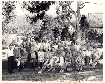
Photograph - Kew Elder Citizens' Club, Lyons 'Mountain Grand' Warburton, Unknown, 1978
... at South Esk by the Hon. E.P. Cameron M.L.C, Minister of Health... at South Esk by the Hon. E.P. Cameron M.L.C, Minister of Health ...The orthodox version of the origins and history of the Kew Elder(ly) Citizens’ Association was established by Cr. W. D. Vaughan in his book Kew’s Civic Century (1960), when he wrote that: "When Mrs. C. H. Simpson was Mayoress in 1952 she set up the Elderly Citizens’ Association to care for the needs of ages persons in Kew. The idea was strongly supported and a start was made by providing social afternoons for elderly folk at Southesk. Visiting sick people in their homes, providing firewood where needed, and other activities were undertaken by the Association. The aid of Council was sought to further the work. It was decided that a social unit for elderly folk be established at Southesk." (p.126-7). In the following pages, he describes in detail Council’s role in formally establishing the Association. This ‘official’ version was reasserted in the later Thematic Environmental History of the City of Boroondara (2012). However the origins and gestation of community of organisations is rarely straightforward. In 1965, five years after Vaughan’s book was published, the author of East Kew Women’s Club : Twenty Years : 20-7-1945-30-7-1965, writing about the period July 1947 to July 1950, described the role the Club played in establishing the Kew Elder Citizens Association. The author wrote: "At a meeting of the Kew Community Aid, the plight of many elderly people in Kew who were dependent on pensions was raised and in order to ascertain their needs the practice was begun of serving morning tea at the Masonic Hall in Walpole Street, where pensions were then paid. From this beginning the Kew Elder Citizens Association was formed in Kew with wide support, and Club members gave willing support on the committee, in helping serve afternoon tea and in entertainment." (p.4) Photographic evidence also leads to questions about Vaughan’s version of events. A framed photograph in the Society’s Collection shows a Public Meeting to form the Kew Elder Citizens Association in a room at Southesk a year earlier in 1951. Whatever version of the origins of the Association is correct, a later framed photograph in the Society’s collection shows the opening of the completed Clubrooms of the Kew Elder Citizens at South Esk by the Hon. E.P. Cameron M.L.C, Minister of Health, on 12 November 1956. The Association is still active in Kew and is currently located at Hamer Court, opposite the Boroondara General (Kew) Cemetery in High Street, Kew.Framed and titled black and white photograph taken on the occasion of a visit by members of the Kew Elder Citizens Club to Lyons "Mountain Grand" Warburton, in February 1978.community groups -- kew (vic.), senior citizens clubs -- kew (vic), club tours -
 Federation University Historical Collection
Postcard, Roslin, c1945
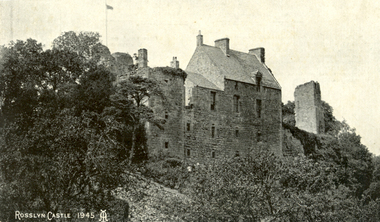
Roslin Castle, the seat of the St Clair Family, was founded in 1304. It is partly in ruins. According to legend some millions of pounds worth of treasure being hidden in the vaults. it is said to be under the charge of a lady of the ancient St Clair family. She is to wake from her slumber and point out the spot where the treasure lies. It is located near the village of Roslin in Midlothian, Scotland. It is located around 9 miles south of Edinburgh, on the north bank of the North Esk, only a few hundred metres from the famous Rosslyn Chapel. (See http://en.wikipedia.org/wiki/Roslin_Castle)Three postcards showing different views of Roslin Castle. .1) A stone building on a hill side, with flying flag, .2) The Courtyard, Roslin Castle .3) The Bakehouse, Roslin Castle.1) This a fine view taken from the Glen. Formerly the castle was eight storeys high, five above and three underground. .2) While at Edinburgh I went out to Roslin saw there the Castle and Church. They are both very old dating back 500 hundred years. .3) The hole in the wall is the oven, is an immense thing. A fire was lit in the oven then pulled out and the heat in the stone did the baking.roslin, rosslyn, roslin castle, st clair, spirit, ghost, baking, oven, bread