Showing 55 items
matching south-east forests
-
 Whitehorse Historical Society Inc.
Map, Parks and recreation facilities, 1/06/1995 12:00:00 AM
... south burwood east forest hill mitcham nunawading vermont ...Map of the City of Whitehorse with parks and reserves marked and indexedMap of the City of Whitehorse with parks and reserves marked and indexed.Map of the City of Whitehorse with parks and reserves marked and indexedcity of whitehorse, parks and reserves, bicycle paths, recreation facilities, blackburn, blackburn north, blackburn south, burwood east, forest hill, mitcham, nunawading, vermont, vermont south -
Whitehorse Historical Society Inc.
Map, Waverley, c1985
... Mitcham melbourne blackburn south burwood east vermont vermont ...Map of Waverley, including Box Hill Soiuth, Blackburn South, Vermont, Vermont South, Burwood East, Burwood, Ashburton, Mount Waverley, Glen Waverley, Oakleigh South, Clayton North and Mulgrave.Map of Waverley, including Box Hill Soiuth, Blackburn South, Vermont, Vermont South, Burwood East, Burwood, Ashburton, Mount Waverley, Glen Waverley, Oakleigh South, Clayton North and Mulgrave. UBD map issued by Nicholls Gledhill Real Estate Agents. Scale 1:50,000.Map of Waverley, including Box Hill Soiuth, Blackburn South, Vermont, Vermont South, Burwood East, Burwood, Ashburton, Mount Waverley, Glen Waverley, Oakleigh South, Clayton North and Mulgrave. blackburn south, burwood east, vermont, vermont south, forest hill -
Whitehorse Historical Society Inc.
Map, City of Whitehorse, 1/03/1995 12:00:00 AM
Map of City of Whitehorse prepared by Richard Meloni showing roads, railways, creeks.Map of City of Whitehorse prepared by Richard Meloni showing roads, railways, creeks.Map of City of Whitehorse prepared by Richard Meloni showing roads, railways, creeks.blackburn, nunawading, blackburn south, mitcham, vermont, vermont south, blackburn north, forest hill, burwood east, city of whitehorse -
Whitehorse Historical Society Inc.
Map, Heritage overlay map, 1/02/1999 12:00:00 AM
City of Whitehorse heritage review : Heritage overlay map.City of Whitehorse heritage review : Heritage overlay map.City of Whitehorse heritage review : Heritage overlay map.city of whitehorse, historic buildings, blackburn, blackburn south, blackburn north, mitcham, nunawading, forest hill, vermont, vermont south, burwood east -
Whitehorse Historical Society Inc.
Map, Shire of Blackburn and Mitcham, 1938
... blackburn north blackburn south burwood east forest hill mitcham ...Plan of Shire of Blackburn and Mitcham showing sections and lot numbers. Scale 8 chains to 1 inch.Plan of Shire of Blackburn and Mitcham showing sections and lot numbers. Scale 8 chains to 1 inch.Plan of Shire of Blackburn and Mitcham showing sections and lot numbers. Scale 8 chains to 1 inch.shire of blackburn and mitcham, blackburn, blackburn north, blackburn south, burwood east, forest hill, mitcham, nunawading, vermont, vermont south -
Whitehorse Historical Society Inc.
Map, Shire of Blackburn and Mitcham, c1935
... blackburn north blackburn south burwood east forest hill mitcham ...Map of Shire of Blackburn and Mitcham showing refuse collection days, sections and lot numbers. Scale 8 chains to 1 inch.Map of Shire of Blackburn and Mitcham showing refuse collection days, sections and lot numbers. Scale 8 chains to 1 inch.Map of Shire of Blackburn and Mitcham showing refuse collection days, sections and lot numbers. Scale 8 chains to 1 inch.shire of blackburn and mitcham, blackburn, blackburn north, blackburn south, burwood east, forest hill, mitcham, nunawading, vermont, vermont south -
Whitehorse Historical Society Inc.
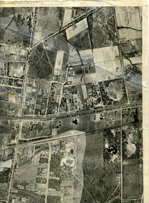
Map, Aerial maps, 2/04/1966 12:00:00 AM
Melbourne 1966 project, runs 10A and 11A, lens 122 151.75 mm 9,800. Photo nos 77, 107, 109, 161, 163, 165.Melbourne 1966 project, runs 10A and 11A, lens 122 151.75 mm 9,800. Photo nos 77, 107, 109, 161, 163, 165. Areas and boundaries: Map no 77 W. Park and Cook Roads; E. Dubon Rd; N Oban Rd; S Reilly St. Map No 107. W. Indra Rd and Pakenham St; E. Rooks Rd & McLares Rd; N. Maroondah Hwy; S. Hawthorn Rd & Eley Rd. Map No 109 W. Elgar Rd. E. Blackburn Rd & McKean St; S. Eley Rd & Burwood Hwy. Map No 161. W. Elgar Rd & Huntingdale Rd; E. Blackburn Rd; N. Burwood Hwy; S. Waverley Rd. Map No 163. W. Blackburn Rd; S. Springvale Rd; N. Eley Rd & Hawthorn Rd; S. Glen Waverley Railway Line. Map No 165. W. Stanley Rd, Vermont South; E. Cathies Lane, Wantirna South; N. North of Burwood Hwy; S. High Street. Melbourne 1966 project, runs 10A and 11A, lens 122 151.75 mm 9,800. Photo nos 77, 107, 109, 161, 163, 165. aerial photographs, blackburn, blackburn south, forest hill, nunawading, box hill, burwood, burwood east, donvale, mount waverley, glen waverley, wantirna, vermont south, mitcham, ringwood north, ringwood -
Whitehorse Historical Society Inc.
Map, City of Nunawading, 1/02/1973 12:00:00 AM
... burwood east forest hill mitcham nunawading vermont vermont south ...Map of City of Nunawading shoeing open creeks or watercourses and watercourses that have been piped.Map of City of Nunawading shoeing open creeks or watercourses and watercourses that have been piped. Scale: 800 feet =1 inchMap of City of Nunawading shoeing open creeks or watercourses and watercourses that have been piped. blackburn, blackburn north, blackburn south, burwood east, forest hill, mitcham, nunawading, vermont, vermont south, city of nunawading, creeks -
Whitehorse Historical Society Inc.
Map, Shire of Blackburn and Mitcham, 10/10/1939 update
... burwood east forest hill mitcham nunawading vermont vermont south ...Map of Shire of Blackburn and Mitcham showing Departmental ball hydrants and departmental pillar ball hydrants.Map of Shire of Blackburn and Mitcham showing Departmental ball hydrants and departmental pillar ball hydrants. Scale 8 chains to 1 inch.Map of Shire of Blackburn and Mitcham showing Departmental ball hydrants and departmental pillar ball hydrants.shire of blackburn and mitcham, fire hydrants, blackburn, blackburn north, blackburn south, burwood east, forest hill, mitcham, nunawading, vermont, vermont south -
Whitehorse Historical Society Inc.
Map, Nunawading Planning Scheme, 7/06/1994 12:00:00 AM
Local Section maps 1 - 4 with index. Geographical information system land Information Branch. Scale 1:10,000 Shows zoning under planning scheme.Local Section maps 1 - 4 with index. Geographical information system land Information Branch. Scale 1:10,000 Shows zoning under planning scheme.Local Section maps 1 - 4 with index. Geographical information system land Information Branch. Scale 1:10,000 Shows zoning under planning scheme.blackburn, blackburn north, blackburn south, forest hill, heatherdale, maps, nunawading, vermont, vermont south, town planning, burwood east, laburnum -
Whitehorse Historical Society Inc.
Book, Box Hill Reporter Cricket Association, 1994?
History of the Association, 1894 - 1994 with brief histories of some clubs.History of the Association, 1894 - 1994 with brief histories of some clubs.History of the Association, 1894 - 1994 with brief histories of some clubs.box hill reporter district cricket association, blackburn cricket club, blackburn north cricket club, blackburn south cricket club, box hill church of christ cricket club, box hill north cricket club, box hill pioneers cricket club, bulleen templestowe cricket club, burwood district cricket club, burwood heights uniting cricket club, coles myer cricket club, doncaster cricket club, east box hill cricket club, east burwood / bennettswood cricket club, eley park cricket club, forest hill cricket club, glen waverley hawks cricket club, glen waverley / northvale cricket club, heatherdale cricket club, koonung heights cricket club, mazenod old collegians cricket club, mitcham cricket club, mountain crusaders cricket club, nunawading cricket club, nunawading churches of christ cricket club, park orchards cricket club, st davids cricket club, syndal cricket club, vermont south cricket club, wheelers hill cricket club, yarraleen cricket club -
 Whitehorse Historical Society Inc.
Map, Photo-map Ringwood A4A, 1945
Aerial photo covering approximately from Box Hill to Mitcham (West to East) and Springfield Road to Hawthorn Road (North to south).Aerial photo covering approximately from Box Hill to Mitcham (West to East) and Springfield Road to Hawthorn Road (North to south). Names of main roads inscribed.Aerial photo covering approximately from Box Hill to Mitcham (West to East) and Springfield Road to Hawthorn Road (North to south).aerial photographs, box hill, blackburn, nunawading, forest hill, mitcham -
 Whitehorse Historical Society Inc.
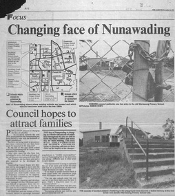
Newspaper - Article, Changing face of Nunawading, 8/09/1993
Article from Nunawading Gazette, 1993, concerning the selling of so many schools in Nunawading and the impact of the increase of population from the extra houses being built.Article from Nunawading Gazette, 1993, concerning the selling of so many schools in Nunawading and the impact of the increase of population from the extra houses being built. The concern is whether sufficient public facilities will be available. Council would oppose any moves to close more schools.Article from Nunawading Gazette, 1993, concerning the selling of so many schools in Nunawading and the impact of the increase of population from the extra houses being built. land subdivision, school buildings, glickman, ray, abbott, kevin, dollis, dimitri, maclellan, robert, middlefield primary school, blackburn technical school, city of nunawading, blackburn south primary school, no. 4035, narmara primary school, burwood east, blackburn east primary school, no. 4800, forest hill secondary college, nunawading campus, heatherdale primary school, warrawong primary school -
 Whitehorse Historical Society Inc.
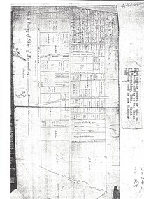
Map, Shire of Nunawading 1888
Plan showing owners of land in the South Riding of the Shire of Nunawading, 1888. South Boundary Road is now Highbury Road.shire of nunawading. south riding, south boundary road, burwood east, highbury road, springvale road, mahoneys road, forest hill, holland road, blackburn south, burwood highway -
Whitehorse Historical Society Inc.
Map, City of Nunawading, c. 1960
... Blackburn South Burwood East Vermont South Forest Hill Vermont Map ...Map showing boundaries of the City of Nunawading Scale: 1:36,000Map showing boundaries of the City of Nunawading Scale: 1:36,000Map showing boundaries of the City of Nunawading Scale: 1:36,000mitcham, nunawading, blackburn, blackburn north, blackburn south, burwood east, vermont south, forest hill, vermont -
 Whitehorse Historical Society Inc.
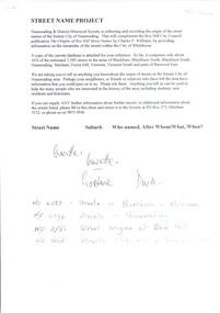
Document, Street Name Project, 2000 onwards
Nunawading & District Historical Society Inc collected the origins of street names to be an on-going projectNunawading & District Historical Society Inc collected the origins of street names to be an on-going projectNunawading & District Historical Society Inc collected the origins of street names to be an on-going projectnunawading district historical society inc, burwood east, street names, vermont south, blackburn, vermont, blackburn north, blackburn south, nunawading, mitcham, forest hill -
 Whitehorse Historical Society Inc.
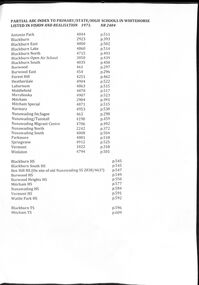
Document - Centenary History of State Education in Victoria, Victorian Education Department, Centenary History, 1973
Selected pages of schools in the Nunawading area from "Vision and Realisation". A Centenary History of State Education in Victoria. N.B. State schools are now called Primary SchoolsA list and description of schools in Whitehorse from "Vision and Realisation"A4 photocopy of 58 selected pages from "Vision and Realisation": a "Centenary History of State Education in Victoria" by the Victorian Education Department. Volume 3 dealing with schools in the Nunawading areavictorian education department, burwood east state school no.454, nunawading (sagoe common school) (box hill) no.463, nunawading (boroondara) catholic school no.464, nunawading state school (canterbury road) no.469, vermont state school. no 1022, burwood east state school no 461, nunawading north state school no 2242, mitcham state school no.2904, blackburn state school no.2923, blackburn open air school no.3850, blackburn south state school no. 4035, nunawading state school no.4190, forest hill state school no.4251, nunawading migrant centre no.4706, blackburn north state school no.4715, tally ho training farm no.3588, winlaton girls youth training centre no.4794, blackburn east state school no.4800, nunawading south state school no.4808, antonio park state school no.4844, blackburn lake state school no.4860, laburnun state school no.4863, mitcham special school no.4871, blackburn high school, blackburn south high school, mitcham high school, nunawading high school, vermont high school, mitcham technical school, primary schools, secondary schools, blackburn technical school -
 Whitehorse Historical Society Inc.
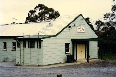
Photograph, Forest Hill Hall
The Forest Hill Hall was built before the 1960s and is situated on the South East side of the intersection of Canterbury and Springvale Rds.The hall seats 70 and can supply tables chairs and a stove. The floor is timber and there is a disability access. There are no parties allowedColoured photograph of a green building with a yellow door. Forest Hill Hall is printed on a board above the doorforest hill hall, halls -
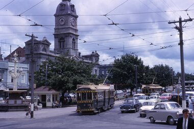
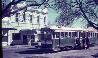 Ballarat Tramway Museum
Slide - 35mm slide/s - set of 3, Dave Simpson, trams in Sturt St near Hospital Corner, late 1960's early 1970's
.1 -No. 35, outbound to Sebastopol with the Southern Cross Hotel in the background. Has signs for Fosters Larger, Carlton Draught and Victoria Bitter. Has a number of passengers boarding the tram. .2 - at Hospital corner with the signal system control box for the Forest City signals in the foreground on a pole. Has marking for Sebastopol, Sturt St West and Drummond St North? written on the box. Above this is a sign advising passengers that trams depart this point for The Gardens, View Point and Sebastopol. In the background is J. A. Malpass Hairdresser shop. See item 8900 for the actual switch. .3 - No. 35 turning into Drummond St south with the bottle shop on the south east corner in the background.Yields information about Hospital corner and the switch for the Forest City signalling system controls.Set of three 35mm slides - AGFA dark blue / white plastic mounts of trams in Sturt St near Hospital Corner. tramways, trams, sturt st, hotels, hospital corner, forest city signals, signs, tram 35 -
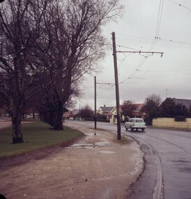 Ballarat Tramway Museum
Slide - 27 mm sq slide/s - set of 8, Lilian Butler, Wendouree Parade - general Scenes, 1971
Yields information about the Wendouree Parade track.Set of 8 AGFA blue and white plastic mount slide of Wendouree Parade. .1 - location?? .2 - near Dowling St? .3 - looking west from the depot towards Forest St with the Jubilee Church in the view. Has a signal in the view showing a red light. .4 - Near Haddon St, showing Warning Oncoming Trams sign. .5 - Looking west from Barrett Ave towards depot loop. .6 - looking east from Barrett Ave .7 - At Haddon St, showing the shelter. .8 - at Martin Ave loop Photo from the collection of Lilian Butler. ballarat, tramways, trams, wendouree parade, haddon st, signs, dowling st, forest st, signals, depot loop, shelters, martin ave, barrett ave -
 Ballarat Tramway Museum
Slide - 35mm slide/s - set of 14, Noel Simons, 23/11/1962 12:00:00 AM
Set of 14 Kodachrome transparencies taken on 23/11/1962. 1162.1 - tram 38 turning into Lydiard St. North from Sturt St. with tram 20 in background. Many motor vehicles in photo. 1162.2 - as above, but a minute of so later. Has Mutual Life building in background as well as Town Hall. 1162.3 - No. 40 entering Albert St. from Skipton St. outbound to Sebastopol. 1162.4 - No. 40 near start of side of the road running in Albert St. heading to Sebastopol. 1162.5 - No. 40 at the City terminus, on the South side of Sturt St. Has Town Hall and other buildings along the south side of Sturt St. in the background. 1162.6 - No. 40 at Sebastopol terminus - shows arrangement of the signs at the terminus. 1162.7 - No. 40 and No. 38 crossing at loop between Sayle and Grey St. No. 40 inbound. 1162.8 - No. 40 turning from Drummond St. South to Sturt St. at Hospital Corner with Southern Cross Hotel in background. 1162.9 - No. 18 in Wendouree Parade near Forest St. heading east with destination of "Victoria St." 1162.10 - Nos 41 and 39 at Depot Junction. Both trams have SEC ads. 1162.11 - No. 39 turning into the depot from Wendouree Parade - showing destination of "Gardens via Drummond Nth" 1162.12- No. 17 at Lydiard St. North terminus, showing destination of "Grey St. Sebas". Has a Twin Lakes sign 1162.13 - ditto, but with trolley pole turned around. Has SEC Briquettes roof ad and Whitehorse whiskey ad on rear dash panel. 1162.14 - No. 40 outbound to Sebastopol crossing Albert St. 1162.1 -"Nos. 38 and 20 in Sturt St. Ballarat at corner of Lydiard St." 1162.2 - "No. 38 turns into Lydiard St. as No. 20 waits at stop in Sturt St. Ballarat" 1162.3 - "No. 40 entering Albert St. from Skipton St. Redan on Sebastopol route." 1162.4 - "No 40 at beginning of reserved track on Sebastopol route, Albert St. Redan." 1162.5 - "No. 40 in Sturt St. Ballarat near cnr. of Armstrong St." 1162.6 - "No. 40 at Sebastopol terminus" 1162.7 - "No. 38 and 40 crossing at Sayle St. Loop on Albert St. reserved track, Sebastopol route" 1162.8 - "No. 40 turning into Sturt St. from Drummond St." 1162.9 - "No. 18 in Wendouree Pde. Ballarat near tramway depot" 1162.10 - "No. 41 and 39 outside Ballarat tramway depot, Lake Wendouree in background" 1162.11 - "No. 39 entering tramway depot from Wendouree Parade, Ballarat" 1162.12 - "No 17 at Lydiard St. North terminus, Ballarat North" 1162.13 - "No 17 at Lydiard St. North terminus, Ballarat North" 1162.14 - "No. 40 crossing Albert St. Sebastopol as reserved track switches from left to right of road" All have date stamp of "23 Nov. 1962" in purple ink. All black ink unless otherwise noted.tramways, trams, ballarat, albert st., sturt st., sebastopol, grey st., hospital corner, wendouree parade, depot junction, lydiard st. north, tram 17, tram 18, tram 20, tram 38, tram 39, tram 40, tram 41 -
 Ballarat Tramway Museum
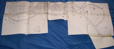
Document - Photocopy, City of Ballaarat, Plan of Gardens, 1920s?
Photocopy - No Number, no date, other than BTM Number 228, No title – plan showing roads and trees in the Gardens area, early drawings, many roads on the east side of Lake Wendouree not built . Photocopy onto heat sensitive paper – 9 separate sheets joined with tape. An additional sheet added at the St. Aidans end showing roads – in pencil. Probably compiled for the BTPS by Bill Kingsley for planning purposes.Has “228” in biro on rear of sheet, and “Scale 100 foot to 1 inch” on front of sheet.trams, tramways, signals, forest city signals, equipment, electrical engineering -
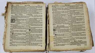 Wodonga & District Historical Society Inc
Book - Haeusler Collection Family Bible early 18th century, Sebastian Göbels, 1702
The Wodonga Historical Society Haeusler Collection provides invaluable insight into life in late nineteenth and early twentieth century north east Victoria. The collection comprises manuscripts, personal artefacts used by the Haeusler family on their farm in Wodonga, and a set of glass negatives which offer a unique visual snapshot of the domestic and social lives of the Haeusler family and local Wodonga community. The Haeusler family migrated from Prussia (Germany) to South Australia in the 1840s and 1850s, before purchasing 100 acres of Crown Land made available under the Victorian Lands Act 1862 (also known as ‘Duffy’s Land Act’) in 1866 in what is now Wodonga West. The Haeusler family were one of several German families to migrate from South Australia to Wodonga in the 1860s. This object is a German bible printed in 1702. It was published by Sebastian Göbels at the town of Schleusingen in the Thüringian Forest, and has 1770 pages. The bible was brought to Australia by the Haeusler-Klinge family when they migrated to South Australia in 1846. Ferdinand Haeusler came to Wodonga with other German families in 1866, bringing the bible with him. This item significant due to its age and rarity. It has well documented provenance and a known owner. It forms part of a significant and representative historical Haeusler Collection, which reflects the local history of Wodonga. It contributes to our understanding of European colonisation and settlement in Wodonga and north east Victoria in the mid nineteenth-century. A large bible printed in German and bound with brown leather. bible, christianity, german, germany, immigration, 1800s, 1700s, prussia -
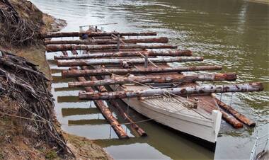 Port of Echuca
Functional object - Outrigger Barge, Murray River Sawmills, D26, 1926
The D26 is an authentic outrigger logging barge - one of four that were towed by P.S. Adelaide for 80 years of its working life. In March 1987 Council purchased the barge from Deakin Shire in South Australia for $15,000. However, its restoration was put on hold until the crew had completed work on the P.S. Enterprise, eventually beginning in 1988 using local red gum. The barge was relaunched at Echuca East on Australia Day, 1990. The D26 remains at the Port of Echuca and on special occasions can be seen being towed by the P.S. Adelaide for demonstrations. The restored D26 outrigger barge is an example of early 20th century boat building technology developed for transporting reg gum logs downstream along the Murray River, often from the Barmah Forest to the Murray River Sawmills at Echuca. It shows the resourcefulness and manual transport techniques for a timber that does not float and had to be chained to the outrigging logs laying perpendicular to the hull. These outrigger barges could be let go to float with the current downstream with a bargeman onboard. Often there was no tiller or helm, but a chain was tied to the ballast at the back to keep the barge in the centre of the river channel. This allowed the Murray River Sawmills built 4 barges to go behind the PS Adelaide, the A11, the B22, the C24 and the D26. Timber outrigger logging bargeD26d26, p.s. adelaide, logging industry, murray river sawmill -
 Bendigo Historical Society Inc.
Document - ALBERT RICHARDSON COLLECTION: BLACK FOREST COMPANY
Five page handwritten and typed document with information about the Black Forest Gold Mine on the Hustler's line of reef. The Black Forest mine was situated one mile north of the Eaglehawk Post Office. To the west was the South New Moon on the Garden Gully line of reef and to the east was the Lightning Hill line of reef worked by open cutting to a depth of over 100 ft by Pascoe and Simonds. A party of Germans named 'Rothacker and Party', first worked the claim on the Black Forest mine approx. 1860. Other mines worked on the Hustler's line north of the Black Forest were: Martha Company. Johns and company and Meaner (unclear) and Co.bendigo, mining, black forest gold mine