Showing 231 items matching "st andrews road"
-
 Eltham District Historical Society Inc
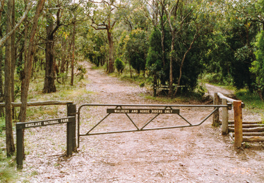
Photograph, Mt Everard Track at Marshalls Road, St Andrews, 7 December 1992, 07/12/1992
... Mt Everard Track at Marshalls Road, St Andrews, 7 December... at Marshalls Road, St Andrews, 7 December 1992 Photograph ...The Eltham Horse Trail: Research and Warrandyte to Kinglake: Survey of proposed route, December 1992: (3) Kangaroo Ground to KinglakeColour photographeltham horse trail (1992 survey), st andrews, marshalls road, mt everard track -
 Eltham District Historical Society Inc
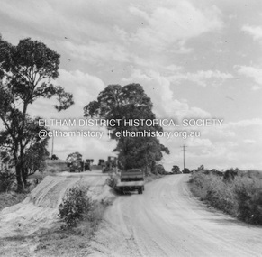
Album - Photograph, J.A. McDonald, Kangaroo Ground-Queenstown Road, Mar. 1959
... Kangaroo Ground-St Andrews Road...(Kangaroo Ground-St Andrews Road) Realignment South of Alma... melbourne (Kangaroo Ground-St Andrews Road) Realignment South ...(Kangaroo Ground-St Andrews Road) Realignment South of Alma Road, Panton Hill Opposite CA Sec., Parish of Greensborough March 1959Record of various Shire of Eltham infrastructure works undertaken during the period of 1952-1962 involving bridge and road reconstruction projects, sometimes with Eltham Shire Council Project Reference numbers quoted. It was during this period that a number of significant improvements were made to roads and new bridges constructed within the shire that remain in place as of present day (2022). In many situations, the photos provide a tangible visible record of infrastructure that existed throughout the early days of the Shire. The album was put together by or under the direction of the Shire Engineer, J.A. McDonald.infrastructure, shire of eltham, bridge construction, heidelberg-kinglake road, road construction, 1959-03, alma road, kangaroo ground-queenstown road, kangaroo ground-st andrews road, panton hill -
 Eltham District Historical Society Inc
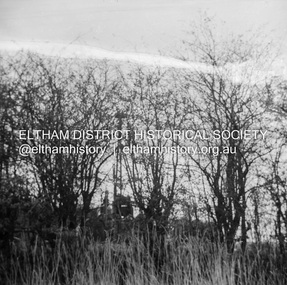
Negative - Photograph, J.A. McDonald, Kangaroo Ground-Queenstown Road, Aug. 1960
... Kangaroo Ground-St Andrews Road...-St Andrews Road) “Rymers” Corner – shifting Hawthorn hedges...-St Andrews Road) “Rymers” Corner – shifting Hawthorn hedges ...Beginning of roll of film Most likely at (Kangaroo Ground-St Andrews Road) “Rymers” Corner – shifting Hawthorn hedges on Tompkins property August 1960Record of various Shire of Eltham infrastructure works undertaken during the period of 1952-1962 involving bridge and road reconstruction projects, sometimes with Eltham Shire Council Project Reference numbers quoted. It was during this period that a number of significant improvements were made to roads and new bridges constructed within the shire that remain in place as of present day (2022). In many situations, the photos provide a tangible visible record of infrastructure that existed throughout the early days of the Shire. The album was put together by or under the direction of the Shire Engineer, J.A. McDonald.infrastructure, shire of eltham, 1960-08, garden hill, kangaroo ground, kangaroo ground-queenstown road, kangaroo ground-st andrews road, rymers corner -
 Eltham District Historical Society Inc
Slide - Photograph, Mittons Bridge Road, St Andrews, c.Nov. 2001
... Mittons Bridge Road, St Andrews... Society meeting of 14 Nov. 2001 st andrews Mittons Bridge Road ...Part of a slide show presentation "A Trip Down the Diamond Creek" by Russell Yeoman to the Eltham District Historical Society meeting of 14 Nov. 200135mm colour positive transparency Mount - Black and Whitest andrews, mittons bridge road -
 Eltham District Historical Society Inc
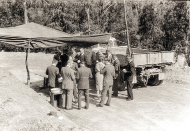
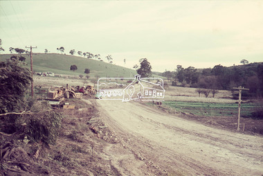
Photograph, Country Road Board members having morning tea just south of St Andrews, Heidelberg-Kinglake Road, 1962, 1962
... St Andrews, Heidelberg-Kinglake Road, 1962... Road Board members having morning tea just south of St Andrews ...Black and white photograph of Council and Country Road Board group with truckheidelberg kinglake road, kinglake road -
 Eltham District Historical Society Inc
Negative - Photograph, J.A. McDonald, Kangaroo Ground-Queenstown Road, Aug. 1960
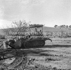
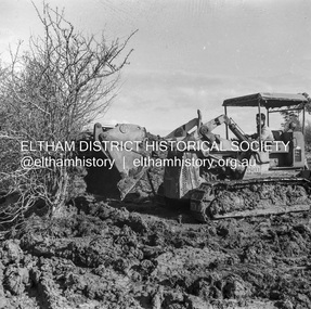
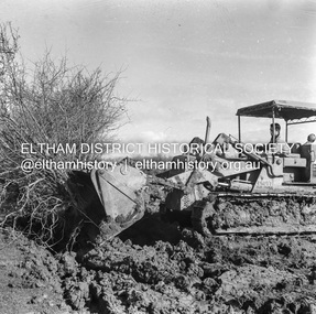
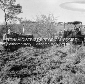
... Kangaroo Ground-St Andrews Road...(Kangaroo Ground-St Andrews Road) “Rymers” Corner...(Kangaroo Ground-St Andrews Road) “Rymers” Corner ...(Kangaroo Ground-St Andrews Road) “Rymers” Corner – shifting Hawthorn hedges on Tompkins property Council’s Drott 6 Woods Drott 9 August 1960 Showing hedge in rear already transported EDHS_05569-55 (EDHS_05577-3/4) and EDHS_05569-56 (EDHS_05577-5/6) - Hawthorn Hedges, Kangaroo Ground 50-50 ELTHAM, CUT THE HEDGES! While all of us are talking about the road toll, Eltham Council must have been in long recess. Around Kangaroo Ground are farmers’ hawthorn hedges shrouding dangerous corners on busy roads. If the council does not insist on their removal for a distance clear enough for safe driving, then it must be held culpable for the accidents that are bound to happen. – WAKE UP (Melbourne) ELTHAM, CUT THE HEDGES! 50-50 (1960, 6 January), The Sun (News clipping held in SEA_74-1_007) ‘BAD HEDGES’ WILL GO “We know there are some bad hedges on corners in the Kangaroo Ground area, but roadworks this year will eliminate them,” the Eltham Shire secretary, Mr Maxwell B. Watson, said yesterday. A reader in 50-50 yesterday complained of farmers’ hawthorn hedges obscuring drivers’ views at bad corners on busy roads in the Kangaroo Ground district. Mr Watson said the roadworks were deviations to remove the sharp turns, and the road would cut back into paddocks. The hedges would go at the same time. Meanwhile, the shire had power to require owners to cut back hedges, and this would be done if specific instances were reported and found justifiable. ‘BAD HEDGES’ WILL GO (1960, January 7), The Sun (News clipping held in SEA_74-1_007)Record of various Shire of Eltham infrastructure works undertaken during the period of 1952-1962 involving bridge and road reconstruction projects, sometimes with Eltham Shire Council Project Reference numbers quoted. It was during this period that a number of significant improvements were made to roads and new bridges constructed within the shire that remain in place as of present day (2022). In many situations, the photos provide a tangible visible record of infrastructure that existed throughout the early days of the Shire. The album was put together by or under the direction of the Shire Engineer, J.A. McDonald.infrastructure, shire of eltham, 1960-08, garden hill, kangaroo ground, kangaroo ground-queenstown road, kangaroo ground-st andrews road, rymers corner, bulldozer, drott -
 Eltham District Historical Society Inc
Negative - Photograph, J.A. McDonald, Kangaroo Ground-Queenstown Road, Aug. 1960
... Kangaroo Ground-St Andrews Road...(Kangaroo Ground-St Andrews Road) “Rymers” Corner...(Kangaroo Ground-St Andrews Road) “Rymers” Corner ...(Kangaroo Ground-St Andrews Road) “Rymers” Corner – shifting Hawthorn hedges on Tompkins property Council’s Drott 6 Woods Drott 9 August 1960 Showing method of lifting clumps of Hawthorn EDHS_05569-55 (EDHS_05577-3/4) and EDHS_05569-56 (EDHS_05577-5/6) - Hawthorn Hedges, Kangaroo Ground 50-50 ELTHAM, CUT THE HEDGES! While all of us are talking about the road toll, Eltham Council must have been in long recess. Around Kangaroo Ground are farmers’ hawthorn hedges shrouding dangerous corners on busy roads. If the council does not insist on their removal for a distance clear enough for safe driving, then it must be held culpable for the accidents that are bound to happen. – WAKE UP (Melbourne) ELTHAM, CUT THE HEDGES! 50-50 (1960, 6 January), The Sun (News clipping held in SEA_74-1_007) ‘BAD HEDGES’ WILL GO “We know there are some bad hedges on corners in the Kangaroo Ground area, but roadworks this year will eliminate them,” the Eltham Shire secretary, Mr Maxwell B. Watson, said yesterday. A reader in 50-50 yesterday complained of farmers’ hawthorn hedges obscuring drivers’ views at bad corners on busy roads in the Kangaroo Ground district. Mr Watson said the roadworks were deviations to remove the sharp turns, and the road would cut back into paddocks. The hedges would go at the same time. Meanwhile, the shire had power to require owners to cut back hedges, and this would be done if specific instances were reported and found justifiable. ‘BAD HEDGES’ WILL GO (1960, January 7), The Sun (News clipping held in SEA_74-1_007)Record of various Shire of Eltham infrastructure works undertaken during the period of 1952-1962 involving bridge and road reconstruction projects, sometimes with Eltham Shire Council Project Reference numbers quoted. It was during this period that a number of significant improvements were made to roads and new bridges constructed within the shire that remain in place as of present day (2022). In many situations, the photos provide a tangible visible record of infrastructure that existed throughout the early days of the Shire. The album was put together by or under the direction of the Shire Engineer, J.A. McDonald.infrastructure, shire of eltham, 1960-08, garden hill, kangaroo ground, kangaroo ground-queenstown road, kangaroo ground-st andrews road, rymers corner, bulldozer, drott -
 Eltham District Historical Society Inc
Negative - Photograph, J.A. McDonald, Kangaroo Ground-Queenstown Road, Aug. 1960
... Kangaroo Ground-St Andrews Road...(Kangaroo Ground-St Andrews Road) “Rymers” Corner...(Kangaroo Ground-St Andrews Road) “Rymers” Corner ...(Kangaroo Ground-St Andrews Road) “Rymers” Corner – shifting Hawthorn hedges on Tompkins property Council’s Drott 6 Woods Drott 9 August 1960 EDHS_05569-55 (EDHS_05577-3/4) and EDHS_05569-56 (EDHS_05577-5/6) - Hawthorn Hedges, Kangaroo Ground 50-50 ELTHAM, CUT THE HEDGES! While all of us are talking about the road toll, Eltham Council must have been in long recess. Around Kangaroo Ground are farmers’ hawthorn hedges shrouding dangerous corners on busy roads. If the council does not insist on their removal for a distance clear enough for safe driving, then it must be held culpable for the accidents that are bound to happen. – WAKE UP (Melbourne) ELTHAM, CUT THE HEDGES! 50-50 (1960, 6 January), The Sun (News clipping held in SEA_74-1_007) ‘BAD HEDGES’ WILL GO “We know there are some bad hedges on corners in the Kangaroo Ground area, but roadworks this year will eliminate them,” the Eltham Shire secretary, Mr Maxwell B. Watson, said yesterday. A reader in 50-50 yesterday complained of farmers’ hawthorn hedges obscuring drivers’ views at bad corners on busy roads in the Kangaroo Ground district. Mr Watson said the roadworks were deviations to remove the sharp turns, and the road would cut back into paddocks. The hedges would go at the same time. Meanwhile, the shire had power to require owners to cut back hedges, and this would be done if specific instances were reported and found justifiable. ‘BAD HEDGES’ WILL GO (1960, January 7), The Sun (News clipping held in SEA_74-1_007)Record of various Shire of Eltham infrastructure works undertaken during the period of 1952-1962 involving bridge and road reconstruction projects, sometimes with Eltham Shire Council Project Reference numbers quoted. It was during this period that a number of significant improvements were made to roads and new bridges constructed within the shire that remain in place as of present day (2022). In many situations, the photos provide a tangible visible record of infrastructure that existed throughout the early days of the Shire. The album was put together by or under the direction of the Shire Engineer, J.A. McDonald.infrastructure, shire of eltham, 1960-08, garden hill, kangaroo ground, kangaroo ground-queenstown road, kangaroo ground-st andrews road, rymers corner, bulldozer, drott -
 Eltham District Historical Society Inc
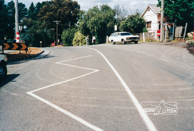
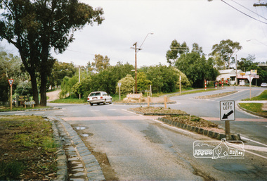
Photograph, Main Road, Panton Hill
... st andrews road... melbourne main road st andrews road kangaroo ground/st andrews road ...Colour photograph of Main Road, Panton Hill looking east. Panton Hill General Store immediately on right just out of view [37�38'31.0"S 145�14'22.5"E -37.641941, 145.239592]main road, st andrews road, kangaroo ground/st andrews road, panton hill -
 Eltham District Historical Society Inc
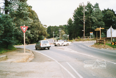
Photograph, Main Road, Panton Hill
... st andrews road... melbourne main road st andrews road kangaroo ground/st andrews road ...Colour photograph of Main Road Panton Hill showing roundabout at Bishops Road.main road, st andrews road, kangaroo ground/st andrews road, bishops road, roundabouts, panton hill -
 Eltham District Historical Society Inc
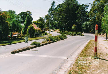
Photograph, Main Road, Panton Hill
... st andrews road... melbourne main road st andrews road kangaroo ground/st andrews road ...Six colour photographs of Main Road Panton Hill showing Bishops Road roundaboutmain road, st andrews road, kangaroo ground/st andrews road, bishops road, roundabouts, panton hill -
 Eltham District Historical Society Inc
Photograph, Main Road, Panton Hill
... st andrews road... melbourne main road st andrews road kangaroo ground/st andrews road ...Two colour photographs of Main Road Panton Hill showing Bishops Road roundaboutmain road, st andrews road, kangaroo ground/st andrews road, bishops road, roundabouts, panton hill -
 Eltham District Historical Society Inc
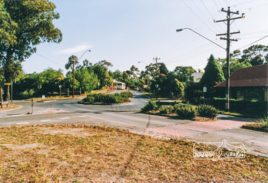
Photograph, Main Road, Panton Hill
... st andrews road... melbourne main road st andrews road kangaroo ground/st andrews road ...Two colour photographs of Main Road Panton Hill showing roundabout at Church Road/Roger Road intersectionmain road, st andrews road, kangaroo ground/st andrews road, church road, roger road, roundabouts, panton hill -
 Eltham District Historical Society Inc
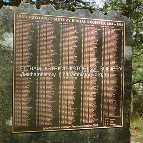
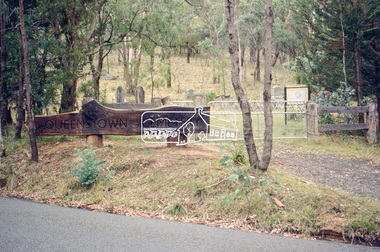
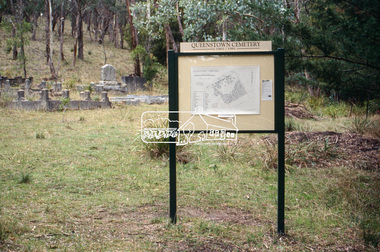
Photograph, Jim Connor, Queenstown Cemetery Burial Register 1861-1981, Queenstown Cemetery, Smiths Gully Road, St Andrews, 8 March 2023
... Cemetery, Smiths Gully Road, St Andrews... 1861-1981, Queenstown Cemetery, Smiths Gully Road, St Andrews ...Installed by the Queenstown Cemetery Trust December 2009 The discovery of gold in Smyth's Creek in 1854 and subsequent gold rush to the Caledonia diggings led to the establishment of Queenstown (present day St Andrews). The first recorded burial was July 31st, 1861 and it was officially declared a Cemetery Reserve in 1866. Many graves are unmarked and unrecorded including many Chinese and other itinerant miners. The cemetery was closed for new burials in 1851. The last recorded burial was in 1981 in an existing family grave.jim connor collection, 2023-03-08, queenstown cemetery, smiths gully road, st andrews -
 Eltham District Historical Society Inc
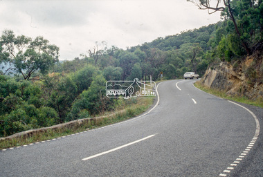
Slide - Photograph, Heidelberg-Kinglake Road, St Andrews, 1993
... Heidelberg-Kinglake Road, St Andrews... Heidelberg-Kinglake Road, St Andrews Slide Photograph ...35mm colour positive transparency Mount - Black and Whiteinfrastructure, streets, roads, heidelberg-kinglake road, st andrews -
 Eltham District Historical Society Inc
Slide - Photograph, Queenstown Cemetery, Smiths Gully Road, St Andrews, c.2004
... Queenstown Cemetery, Smiths Gully Road, St Andrews... gully road st andrews 35mm colour positive transparency Mount ...The discovery of gold in Smyth's Creek in 1854 and subsequent gold rush to the Caledonia diggings led to the establishment of Queenstown (present day St Andrews). The first recorded burial was July 31st, 1861 and it was officially declared a Cemetery Reserve in 1866. Many graves are unmarked and unrecorded including many Chinese and other itinerant miners. The cemetery was closed for new burials in 1851. The last recorded burial was in 1981 in an existing family grave.35mm colour positive transparency Mount - white 7 dots (Technodia Italy)queenstown cemetery, smiths gully road, st andrews -
 Eltham District Historical Society Inc
Slide - Photograph, Mittons Bridge, Mittons Bridge Road, St Andrews, c.1993
... Mittons Bridge, Mittons Bridge Road, St Andrews... Bridge Mittons Bridge Road St Andrews 35mm colour positive ...35mm colour positive transparency Mount - Black and Whiteinfrastructure, roads, heidelberg-kinglake road, mittons bridge, mittons bridge road, st andrews -
 Eltham District Historical Society Inc
Slide - Photograph, Sculptures, Ninks Road, St Andrews, c.Nov. 2001
... Sculptures, Ninks Road, St Andrews... transparency Mount - Black and White Sculptures, Ninks Road, St Andrews ...Part of a slide show presentation "A Trip Down the Diamond Creek" by Russell Yeoman to the Eltham District Historical Society meeting of 14 Nov. 200135mm colour positive transparency Mount - Black and Whiteart in public places, ninks road, public art, sculptures, st andrews -
 Eltham District Historical Society Inc
Slide - Photograph, Private crossing over the Diamond Creek, Ninks Road, St Andrews North, c.Nov. 2001
... Private crossing over the Diamond Creek, Ninks Road, St... Society meeting of 14 Nov. 2001 Diamond Creek Ninks Road St ...Part of a slide show presentation "A Trip Down the Diamond Creek" by Russell Yeoman to the Eltham District Historical Society meeting of 14 Nov. 200135mm colour positive transparency Mount - Black and Whitediamond creek, ninks road, st andrews north -
 Eltham District Historical Society Inc
Slide - Photograph, Private crossing over the Diamond Creek, Ninks Road, St Andrews North, c.Nov. 2001
... Private crossing over the Diamond Creek, Ninks Road, St... Society meeting of 14 Nov. 2001 diamond creek ninks road st ...Part of a slide show presentation "A Trip Down the Diamond Creek" by Russell Yeoman to the Eltham District Historical Society meeting of 14 Nov. 200135mm colour positive transparency Mount - Black and Whitediamond creek, ninks road, st andrews north -
 Eltham District Historical Society Inc
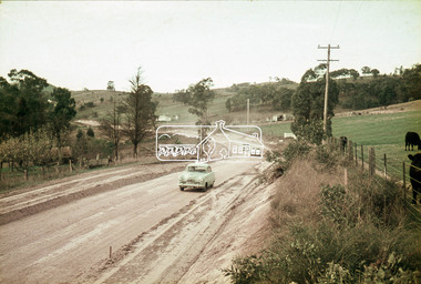
Photograph, Kinglake Road, St Andrews, near Mittons Bridge, c.1966-c.1968, 1967c
... Kinglake Road, St Andrews, near Mittons Bridge, c.1966-c...Heidelberg-Kinglake Road, Mittons Bridge, St Andrews... melbourne Heidelberg-Kinglake Road, Mittons Bridge, St Andrews ...35mm Colour positive transparency Mount - Agfacolor Service (Blue stepped)inscribed (b) Rolling caster? and 2heidelberg-kinglake road, mittons bridge, st andrews -
 Eltham District Historical Society Inc
Photograph, Kinglake Road, St Andrews, near Mittons Bridge, c.1966-c.1968, 1967c
... Kinglake Road, St Andrews, near Mittons Bridge, c.1966-c...heidelberg-kinglake road, mittons bridge, st andrews... melbourne heidelberg-kinglake road, mittons bridge, st andrews 35mm ...35mm Colour positive transparency Mount - Agfacolor Service (Blue stepped)heidelberg-kinglake road, mittons bridge, st andrews -
 Eltham District Historical Society Inc
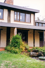
Photograph, Gayle Blackwood, Glendearg, 85 Dinsdale Road, St Andrews, April 1998
... Glendearg, 85 Dinsdale Road, St Andrews, April 1998... sales brochure Glendearg, 85 Dinsdale Road, St Andrews, April ...Robert Marshall designed mudbrick home17 colour prints 10 x 15 cm Three newspaper clippings 1 A4 McGorlicks Real Estate sales brochurehouses, mudbrick, gayle blackwood collection, dinsdale road, glendearg, mcgorlick real estate, robert marshall, st andrews -
 Eltham District Historical Society Inc
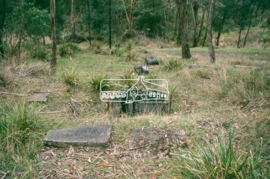
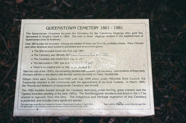
Photograph - Digital Photograph, Alan King, Queenstown Cemetery, Smiths Gully Road, St Andrews, 28 December 2007
... Queenstown Cemetery, Smiths Gully Road, St Andrews... Cemetery Smiths Gully Road St Andrews William Band Born digital ...The discovery of gold in Smyth's Creek in 1854 and subsequent gold rush to the Caledonia diggings led to the establishment of Queenstown (present day St Andrews). The first recorded burial was July 31st, 1861 and it was officially declared a Cemetery Reserve in 1866. Many graves are unmarked and unrecorded including many Chinese and other itinerant miners. The cemetery was closed for new burials in 1851. The last recorded burial was in 1981 in an existing family grave. In Loving memory of David Band Died 30th Decr. 1862, aged 51 years. John Cork Knell Died 11th April 1867, aged 42 years. Eliza Smith Died 20th Jany. 1874, aged 3 1/2 years. William Band Died 20th Feby. 1883, aged 51 years. Published: Nillumbik Now and Then / Marguerite Marshall 2008; photographs Alan King with Marguerite Marshall.; p73 The discovery of gold at Smyth’s Creek* in 1854 brought 3000 people to the area in search of their fortunes.1 However in the harsh conditions many miners and their families died young, and were buried in unmarked graves. Their stories died with them but by 1861, the first burial was recorded at the Queenstown Cemetery – that of William Dalrymple aged 65 – although the cemetery was only officially declared a reserve in 1866. Even before this in 1856, a double burial had been recorded for the twin baby daughters of George Harrison at Market Square, the miners’ settlement – presumably where the cemetery is today. In 1951 the Queenstown Cemetery at 70 Smiths Gully Road, Smiths Gully, closed for burials. However the last burial in a family plot, that of Grace Evelyn Smith, occurred in 1981. Today only 55 headstones remain, but more than 380 burials are recorded. Remnant bushland dominates the cemetery where many graves are merely mounds and others have been damaged by vandalism and the neglect of time. Bushfire in 1962 destroyed the picket fencing, grave markers and cypress boundary planted in the early 1900s. The box/stringybark woodland in the 1.7 hectare Cemetery Reserve is regrowth from then and the indigenous and heritage vegetation is protected. Thanks to the volunteer Cemetery Trust and Friends & Relations of Queenstown Cemetery, the cemetery is maintained, stories recorded and the burial index corrected and expanded.2 Close by the cemetery on the site of today’s Peter Franke Picnic and Nature Reserve stood Market Square, the Caledonia Diggings village of tents and stores, the forerunner of Queenstown, now St Andrews. Many of the Caledonia Diggings miners were Chinese, many of whom, with itinerant prospectors, were buried in unmarked graves. Histories are being recorded of other immigrants, mainly English and German, who settled after the gold rush, some of whose descendants fought and died in the two world wars. Names on many headstones are also recorded on the district’s roads, reserves and war memorials such as Motschall, Joyce, Howard and Coutie. The oldest surviving tombstone is that of Scot, David Band who died in 1862 at 51 years. His oldest daughter Elizabeth, with husband John Knell, owned the Queenstown Hotel and the post office. Child-rearing in a colonial gold town was often tragically difficult, as demonstrated in the first 20 years, when 41% of the 34 burials recorded were children. Settlers endured harsh conditions graphically illustrated with the deaths of Annie Joyce at 30 years and of her family. Annie was married to gold miner Walter Joyce. Their third child Walter, born in 1886, died in March 1887. Eight months later Annie died of breast cancer. Walter died in 1909, aged 53, of miner’s phthisic caused by stone dust destroying his lungs. It was so hard to make a living that burials were usually held from 2.30 pm to allow mourners to work a day before paying their last respects.3 Most burials before 1890 were recorded as Anglicans, as the only church on the Caledonia Diggings was the Church of St Andrew, until 1897, when the Primitive Methodist Church came to Panton Hill. Generally miners came to better themselves, but some, like Grace Hopkinson (nee Milward), born in England in 1828, came from a well-off and educated family. According to family legend Grace emigrated with husband William, to live in a tent, but had kept her personally embossed sterling silver cutlery service. Amid the tough environment were some successes like that reported in The Evelyn Observer April/May 1901 of miner William Hopkinson who was buried at the cemetery in 1912 aged 81. The Observer stated that Hopkinson ‘recently dropped across another find in his claim at One Tree Hill’. The lump of gold found this time weighed more than half a kilo. Mr Hopkinson referred to it as ‘another little speck’. *Today’s Smiths GullyThis collection of almost 130 photos about places and people within the Shire of Nillumbik, an urban and rural municipality in Melbourne's north, contributes to an understanding of the history of the Shire. Published in 2008 immediately prior to the Black Saturday bushfires of February 7, 2009, it documents sites that were impacted, and in some cases destroyed by the fires. It includes photographs taken especially for the publication, creating a unique time capsule representing the Shire in the early 21st century. It remains the most recent comprehenesive publication devoted to the Shire's history connecting local residents to the past. nillumbik now and then (marshall-king) collection, david band, eliza smith, gravestones, john cork knell, queenstown cemetery, smiths gully road, st andrews, william band -
 Eltham District Historical Society Inc
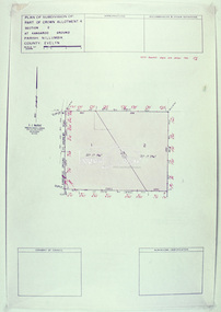
Slide - Photograph, Eltham Shire Council, Plan of Subdivision of Part of Crown Allotment 4, Section 2 at Kangaroo Ground, Parish of Nillumbik, County of Evelyn, 1969
... C6, Kimse, Kangaroo Ground-St Andrews Road, 4 August 1969..., Kimse, Kangaroo Ground-St Andrews Road, 4 August 1969 35mm ...35mm colour positive transparency blue Agfacolour Service plastic mountC6, Kimse, Kangaroo Ground-St Andrews Road, 4 August 1969infrastructure, kangaroo ground, kangaroo ground-st andrews rd, kimse, map, plan of subdivision, planning, subdivison lots -
 Eltham District Historical Society Inc
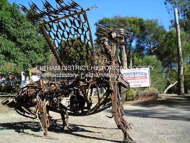
Photograph, Fay Bridge, Scrap iron sculpture outside St Andrews Stockfeed, 66 Caledonia St, St Andrews, 31 March 2019
... St Andrews Road... Click here to add keywords sculpture St Andrews St Andrews Road ...fay bridge collection, 2019-04-07, art, caledonia street, click here to add keywords, sculpture, st andrews, st andrews road, st andrews stockfeed