Showing 1802 items
matching subdivision
-
 Whitehorse Historical Society Inc.
Photograph, Subdivision in Ottawa Street, Blackburn, 1971
Black and white photo of Subdivision in Ottawa Street, Blackburn in 1971.ottawa street, blackburn -
 Tatura Irrigation & Wartime Camps Museum
Poster, Subdivision of Township Allotments
Poster depicting the land which was being sold by J S Darby on the 3 December 1890. Auctioneer was Martin Cussen and Co. Map shows location of land.Single sheet of paper, laminated. Advertising land subdivision for sale in the township of Rushworth. Being sold by Martin Cussen and Co, auctioneers for J S Darby. Shows map of land subdivision.rushworth, land subdivision, martin cussen and co, j s darby -
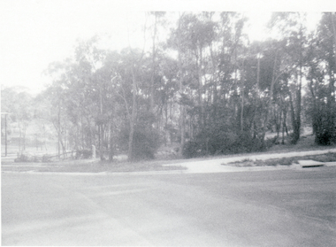
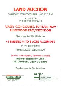 Ringwood and District Historical Society
Flyer, Advertisement for land auction - Pine Lodge Subdivision, Ringwood East / Croydon, Victoria - 1983
Folded A3 double sided page advertising auction of 14 timbered allotments - 3/4 to 4 acres, on Saturday, 10th December, 1983, with terms of sale, location map, and summary of subdivision features.Subdivision includes Angus Avenue, Vasey Concourse and Ruthven Way, Ringwood East, and Cheong Street, Croydon, Victoria. A covenant has been placed on most titles specifying that only one dwelling house can be erected during the next ten years. Auctioneers in Conjunction - Stockdale & Leggo, 422 Collins Street, Melbourne, (Telephone) 67 6661, A.H. 20 2364, and C.E. Carter & Son, 122 Whitehorse Road, Ringwood, Victoria 3134, (Telephone) 870 6211, A.H. 876 4124. -
 Whitehorse Historical Society Inc.
Photograph, Subdivision of Area of Burwood, 1971
Black and white photo of Subdivision of Area of Burwood, Springvale and Highbury Roads.highbury road, burwood east, springvale road, burwood highway burwood east -
 Greensborough Historical Society
Poster - Planning Document, City of Heidelberg, Subdivision Plan # 19 - Parish of Keelbundoora, Crown Portion 16, Watsonia "Black's subdivision', 1924
Subdivision Plan # 19 - Parish of Keelbundoora, Crown Portion 16, Watsonia "Black's subdivision". This subdivision plan includes proposed street names which were later changed (e.g. Morwell Street (not Morwell Avenue) now called Greenwood Drive). Includes Lambourn Road, Black Street, Grace Street, Eden Avenue, High Street, Kenmare Street, Morwell Avenue, Greensborough Road, Mundy Street, Ladd Street.An example of hard copy subdivision plans from the Greensborough area. Mainly from the Shire of Diamond Valley era (1964-1994).Plan (single sided) mounted on heavy card. Stamped and handwritten Council permissions, dates and other details. subdivision plans, city of heidelberg, greensborough, main street greensborough, shire of heidelberg, watsonia, black family -
Ringwood and District Historical Society
Pamphlets, N.R. Reid & Co Pty Ltd, Subdivision pamphlet Hunter Estate Ringwood, 1959
The Hunter Estate, from Wonga Road to Mullum Mullum Road including Panfield Avenue, Hunter Avenue and Hendra Grove.Bifold pamphlet green black and white printing, plan of subdivision on second page -
 Ringwood and District Historical Society
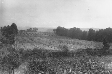
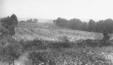
Photograph, Godbehear's orchard in Warrandyte Road North Ringwood, prior to subdivision. (undated)
Typed below photograph, "Godbehear's orchard prior to subdivision". -
 Kew Historical Society Inc
Plan - Subdivision Plan, Plan of Subdivision of Crown Portion 71, Parish of Boroondara LP12509, Vol.1678, Fol.335526, Before 1930
Prue Sanderson, in her groundbreaking ‘City of Kew Urban Conservation Study : Volume 2 - Development History’ (1988), summarised the periods of urban development and subdivisions of land in Kew. The periods that she identified included 1845-1880, 1880-1893, 1893-1921, 1921-1933, 1933-1943, and Post-War Development. These periods were selected as they represented periods of rapid growth or decline in urban development. An obvious starting point for Sanderson’s groupings involved population growth and the associated economic cycles. These cycles also highlighted urban expansion onto land that was predominantly rural, although in other cases it represented the decline and breakup of large estates. A number of the plans in the Kew Historical Society’s collection can also be found in other collections, such as those of the State Library of Victoria and the Boroondara Library Service. A number are however unique to the collection.Subdivision plans are historically important documents used as evidence of the growth of suburbs in Australia. They frequently provide information about when the land was sold on which a built structure was subsequently constructed as well as evidence relating to surveyors and real estate and financial agents. The numerous subdivision plans in the Kew Historical Society's collection represent working documents, ranging from the initial sketches made in planning a subdivision to printed plans on which auctioneers or agents listed the prices for which individual lots were sold. In a number of cases, the reverse of a subdivision plan in the collection includes a photograph of a house that was also for sale by the agent. These photographs provide significant heritage information relating house design and decoration, fencing and household gardens.The six lots on the south side of Macartney Avenue, between Macartney Avenue and Daniell Place were part of a subdivision that occurred before 1930. The subdivision plan is of interest in that the original name of Daniell Place was Brougham Place. On the Plan, it is noted that lots 5 and 6 (currently 10 and 12 Macartney Avenue) had been sold for £13 each. By November 1930, the new six-roomed villa built on 12 Macartney Avenue was offered for immediate sale at a ‘sacrifice price’. Any offer in reason would be considered, although a £350 deposit was required.subdivision plans - kew, mount street - kew, brougham street - kew , macartney avenue - kew -
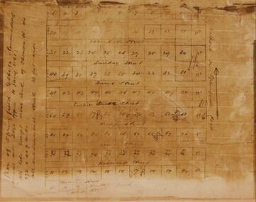
 Ringwood and District Historical Society
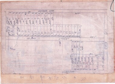
Document, Subdivision Map (Undated) - Ringwood, Victoria
Hand-drawn copy of subdivision plan showing numbered residential allotments with property dimensions.Map includes Wantirna Road, Ireland Street, City Road and Victoria Street (later Regina Street), Ringwood, Victoria. -
 Ringwood and District Historical Society
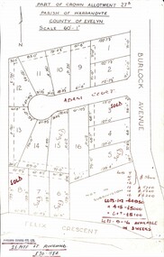
Map, Subdivision Plan - Adam Court area, North Ringwood, Vic. - circa 1960s
Single page plan printed showing allotments included in un-named subdivision layout surrounding Adam Court, Ringwood North. Subdivision includes Adam Court, Burlock Avenue, and Felix Crescent. Sold allotmenets marked in red, with price notations.Page heading - Part of Crown Allotment 27B Parish of Warrandyte County of Evelyn Scale 60'-1". Rubber stamp imprint and handwritten address at bottom of page - "Binburra Estates Pty. Ltd. 23 Pitt St., Ringwood, 870-1184". -
 Eltham District Historical Society Inc
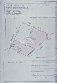
Slide - Photograph, Eltham Shire Council, Plan of Subdivision of Part of Crown Portion 2, Parish of Nillumbik, County of Evelyn, 1969
35mm colour positive transparency blue Agfacolour Service plastic mountC2, Grant of subdivision, Para and Glenauburn, 4 August 1969infrastructure, map, planning, subdivison lots, glenauburn road, para road -
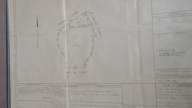 Peterborough History Group
Map - survey of Hamilton St wetland, Plan of Subdivision Hamilton Street
Subdivided to preserve the wetland, locals estimate it occurred between 1976 and 1983A3 plan of subdivision showing the outline of the swamp bounded by Hamilton St, Charles St and Cumming St. peterborough, survey map, golden pond -
 Eltham District Historical Society Inc
Slide - Photograph, Eltham Shire Council, Proposed subdivision of Part of Crown Allotment 8B, Section 8A, Parish of Nillumbik, 1969
35mm colour positive transparency blue Agfacolour Service plastic mountE4, N0424, Stock subdivision, North Warrandyte, 4 August 1969infrastructure, map, planning, subdivison lots -
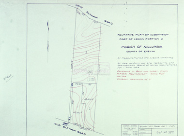
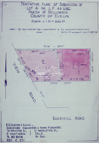 Eltham District Historical Society Inc
Slide - Photograph, Eltham Shire Council, Tentative Plan of Subdivision of Part of Lot 4 on L.P. 44 686, Parish of Nillumbik, County of Evelyn, 1969
35mm colour positive transparency blue Agfacolour Service plastic mountB3 Robinson prelim subdivision, View Road, 4 August 1969infrastructure, map, planning, subdivison lots, view road, rosehill road, lower plenty -
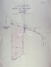 Eltham District Historical Society Inc
Slide - Photograph, Eltham Shire Council, Plan of Subdivision, Part of Crown Portion 3, Parish of Nillumbik, County of Bourke, 1969
35mm colour positive transparency blue Agfacolour Service plastic mountB3 Robinson prelim subdivision, View Road, 4 August 1969infrastructure, map, planning, subdivison lots, rattray road -
 Ringwood and District Historical Society
Photograph, Godbehear's orchard - Warrandyte Rd. Prior to subdivision
Written on backing sheet, "Godbehear's orchard - Warrandyte Rd. Prior to subdivision". -
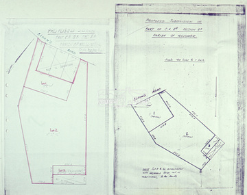
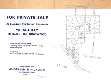 Ringwood and District Historical Society
Document - Folder, Reaghill Estate Subdivision, Ringwood, Victoria - circa 1958
Bifold land sale brochure glued to brown stationery folder with advertisement including map of original subdivision (circa 1958) and subsequent 1982 re-subdivision of Lot 7 Vista Avenue - LP41463 - Part of Crown Allotment 43, Parish of Ringwood, and 4-page brochure for sale of 4 luxury new homes built by Bovis Homes Aust. P/L as presented by Lyndsay Edmonds Homes. Subdivision includes Bedford Road, Homebush Court, Vista Avenue and Vista Court. Original protective covenant: "One dwelling house only on each of Lots 1-15 for a period of 15 years". Agent - Anderson & Hickling, 239 Collins Street, Melbourne. (Phone) Cent.25. -
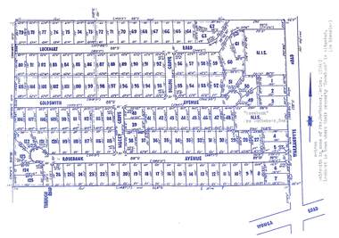 Ringwood and District Historical Society
Map, Subdivision Plan - Rosebank Avenue area, North Ringwood, Vic. - circa 1960s
Single page plan printed on green background showing allotments included in un-named subdivision layout surrounding "Rosebank" property, Warrandyte Road, Ringwood North. Subdivision includes Through Road, Rosebank Avenue, Macey Grove, Goldsmith Avenue, Dillon Grove, Lockhart Road, and Warrandyte Road.Typewritten notation against "Rosebank" property - "Mrs Godbehear, Snr.". "Goldsmith is maiden name of Mrs. Godbehear, Senior. (1960). Lockhart is town where their property "Rosebank" is situated. (In Riverina)". -
Ringwood and District Historical Society
Envelope, Packet: Leis East and Family memorial address 1871-1948; papers about East Property and subdivision
Memorial address for Lewis Findlay East 1871-1948; Hand written letters and papers East property and proposed subdivision. -
 Whitehorse Historical Society Inc.
Map - Civic Map, Subdivision of Village of Springfield, 1861
Map of the subdivision of the Springfield Estate, Nunawading, 1861. The Springfield Estate was located in the Northwest corner of Whitehorse Road and Springvale Road.Map of the subdivision of the Springfield Estate, Nunawading, 1861. Springfield Estate was located in the Northwest corner of Whitehorse Road and Springvale Road.non-fictionMap of the subdivision of the Springfield Estate, Nunawading, 1861. The Springfield Estate was located in the Northwest corner of Whitehorse Road and Springvale Road.springfield estate, whitehorse road nunawading, springvale road nunawading -
 Eltham District Historical Society Inc
Slide - Photograph, Eltham Shire Council, Proposed plan of subdivision, Mrs Du Lee, Warrandyte, 1969
35mm colour positive transparency blue Agfacolour Service plastic mountB2, Du Lee Subdivision, Research-Warrandyte Road, 4 August 1969infrastructure, map, planning, subdivison lots, du lee, glynns road, research-warrandyte road -
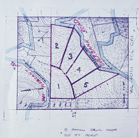 Eltham District Historical Society Inc
Slide - Photograph, Eltham Shire Council, Proposed subdivision of five approximately equal areas of 5 acres, Vol. 4061, Fol. 061, Overbank Road, North Warrandyte, 1969
35mm colour positive transparency blue Agfacolour Service plastic mountD4, 55341, Peck subdivision, Mount Pleasant Road, 4 August 1969infrastructure, map, planning, subdivison lots, overbank road, mount pleasant road, north warrandyte -
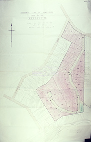
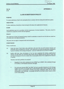 Whitehorse Historical Society Inc.
Document, Land Subdivision Policy, 24/08/1998 12:00:00 AM
Land subdivision policyLand subdivision policy: approved by City of Whitehorse.Ordinary council meeting 24/8/1998, Item 12.1.5 p. 42-43Land subdivision policyland subdivision, city of whitehorse -
Whitehorse Historical Society Inc.
Document, Land Subdivision, cnr Springvale and Burwood Roads, n.d
Hand drawn document of land subdivision,Hand drawn document of land subdivision, Springvale Road & Burwood Road, together with notes of various sales from 1857 to 1957.Hand drawn document of land subdivision, burwood road, vermont south, springvale road, vermont south, stanley road, vermont south, vermont south, mayne, alexander, mayne, james alexander, craig, silas gordon, fankhauser, frederick william, fankhauser, mervyn william, burrell, charles, donaldson, john -
 Eltham District Historical Society Inc
Slide - Photograph, Eltham Shire Council, Tentative Plan of Subdivision, Part of Crown Portion 2, Parish of Nillumbik, County of Evelyn, 1969
35mm colour positive transparency blue Agfacolour Service plastic mountB4, Fisher subdivision, Old Eltham Road and Main Road, 4 August 1969infrastructure, map, planning, subdivison lots, main road, old eltham road -
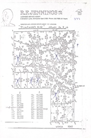 Ringwood and District Historical Society
Document, Land Sale Map and Price List - Pinewood Rise Subdivision, Ringwood, Victoria - (Undated, circa 1988)
Single page black & white photocopy of subdivision plan showing layout of 28 residential allotments with inset showing price list & some marked 'sold'.Director and Licensed Estate Agent - R.F. Jennings Pty Ltd., 8 Streeton Lane, Doncaster East 3109. Phone 842 7666 all hours. -
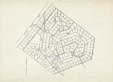 Ringwood and District Historical Society
Map, Plan of Subdivision - Mullum Mullum Road, Ringwood - Circa 1969
Photocopy of subdivision - 128 residential allotments in Mullum Mullum Road, Sonia Street, Linda Drive, Jill Court, Eve Court, and Alma Court, Ringwood. -
 Eltham District Historical Society Inc
Slide - Photograph, Eltham Shire Council, Tentative Plan of Subdivision, Part of Crown Allotment 20A and Part 20B, Parish of Nillumbik, County of Evelyn, 1969
35mm colour positive transparency blue Agfacolour Service plastic mountE2, N899, Young subdivision, Kangaroo Ground-Warrandyte Road, North Warrandyte, 4 August 1969infrastructure, map, planning, subdivison lots, kangaroo ground-warrandyte road, north warrandyte -
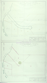
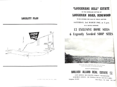 Ringwood and District Historical Society
Document - Folder, Subdivision Auction - Loughnans Hill Estate 1962, Ringwood, Victoria
Double-sided bifold page advertising auction on Saturday 3rd March, 1962 - 13 residential allotments in Hearthside Court and 6 shop sites in Loughnan Road, with map of subdivision, terms of sale, and summary of features and services. Adjoining service station shown on accompanying Plan of Subdivision - Part of Crown Allotment 28 Parish of Warrandyte, also showing location of property known as "Hearth", hence Hearthside Court.Auctioneers - Baillieu Allard Real Estate Pty Ltd., 360 Collins Street, Melbourne, and 302 Toorak Road, South Yarra. Telephone 24-4365, After hours XU1549, WL2471. -
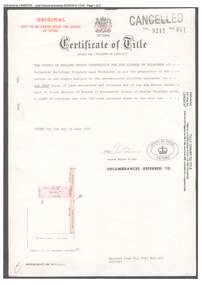 Ringwood and District Historical Society
Document, Certificate of Title 1977 and Subdivision Plan 1999 - 21-23 Bemboka Road Warranwood, Victoria
A4 copies of Landata Victoria Historical Search documents. Certificate of Title Vol 9217 Fol 041 Church of England Trusts Corporation For The Diocese Of Melbourne - part of Crown Section 20, Parish of Warrandyte, County of Evelyn, 7th June, 1977. Includes Plan of Subdivision , postal address Bemboka Road, Warranwood 3134 (north of Lyric Court), certified under Subdivision Act 1988, 8/2/1999.