Showing 69 items
matching surveyors reports
-
 Federation University Historical Collection
Book - Report, Reports of the Mining Surveyors and Registrars, 1867, 30/06/1969 - 31/12/1881
... Reports of the Mining Surveyors and Registrars, 1867... dated 31 December 1881 Reports of the Mining Surveyors ....1) 39 page report dated 30 September 1867 .2) 40 page report dated 31 December 1871 .3) 46 page report dated 30 June 1872 .4) 42 page report dated 31 December 1873 .5) 45 page report dated 30 September 1872 .6) 44 page report dated 31 December 1881gold statistics, mining survey -
 Federation University Historical Collection
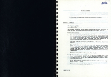
Report, SMB: Review Survey of Buildings and Grounds, July 1985, 1985
Report of the detailed review of The School of Mines and Industries Ballarat Limited undertaken by Alexander & Alexander in 1985. Previous reports were done in 1982 and 1983. The report covers all areas of the school - buildings and grounds. Some sections/buildings are still being completed. Report contains written evaluation, maps/diagrams and photographs.Spiral bound book - dark blue cover. 15 pages of written information plus 3 pages of photographs.Gold lettering on from cover "Alexander & Alexander" Signature "J W Elliott" on page 10 (Loss Control Surveyorballarat school of mines and industries, survey, alexander and alexander, j w elliott, maps, photographs -
 Bendigo Historical Society Inc.
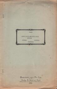
Document - HANRO COLLECTION: PLANS AND REPORT FROM FIRE ENGINEERS AND SURVEYORS, 1954/1960
Plans and Report from Fire Engineers and Surveyors:- Green Card has a rectangular box with an ornate border in the centre of the front page. Inside the border is typed in black *Plans, Hanro (Aust) Knitting Mills Limited, Bendigo Victoria Australia. At the bottom:- Mahlstedt's (Vic) Pty Ltd. (est. 1884). Consulting Fire Engineers and Surveyors. Temple Court, 422 Collins Street., Melbourne C.1. Telephone 673069. Inside the folder is the Key to Detail Block Plans & Fire Surveys. Correspondence from Mahlstedt's Pty Ltd to Edward Lumley and Sons, Insurance Brokers regarding a new survey and the changes to the building with respect to fire hazard. Main report recommendations and general information on the building. Blue print of Shirt Factory, Inglewood Road No. 1061 by Welmar Ltd Bendigo. Small blue print of the main buildings showing different work areas. Blue print No.1119 of John Brown Industries Ltd Alley Street Bendigo showing work areas. Box 116AMahlstedt's (Vic) Pty Ltdhanro, clothing, plans and reports, edward lumley & sons pty ltd. hanro knitting mills. mahlstedt's (vic) pty ltd. welmar ltd bendigo. john brown industries ltd. -
 Bendigo Historical Society Inc.
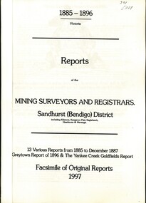
Book - REPORTS OF THE MINING SURVEYORS AND REGISTRARS 1885 - 1896, 1997
... REPORTS OF THE MINING SURVEYORS AND REGISTRARS 1885 - 1896...Reports of the Mining Surveyors and Registrars. Sandhurst... GOLDFIELDS mining reports Reports of the Mining Surveyors ...Reports of the Mining Surveyors and Registrars. Sandhurst (Bendigo) District. 13 various Reports from 1885 to December 1887 Greytown Report of 1896 and the Yankee Creek Goldfields Report. Facsimile of Original Reports 1997.goldfields, mining reports -
 Bendigo Historical Society Inc.
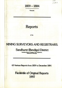
Book - REPORTS OF THE MINING SURVEYORS AND REGISTRARS 1859 - 1884, 1997
... REPORTS OF THE MINING SURVEYORS AND REGISTRARS 1859 - 1884...Reports of the Mining Surveyors and Registrars, 1859 - 1884... GOLDFIELDS mining reports Reports of the Mining Surveyors ...Reports of the Mining Surveyors and Registrars, 1859 - 1884. Covering Sandhurst (Bendigo) district, including Kilmore, Kangaroo Flat, Eaglehawk, Heathcote, and Waranga. 63 various reports from 1859 to December 1884. Facsimile of original reports 1997.goldfields, mining reports -
 Bendigo Historical Society Inc.
Document - VICTORIA SURVEY REPORT 1859 TO 60
Four page report presented to both houses of parliament by Surveyor General CH W Ligar dated 1859-60. Object of survey to establish the best method of delineating the boundaries of new allotments in the colony. Geodetic method recommended.bendigo, history, allottment survey -
Port Melbourne Historical & Preservation Society
Map - Survey Map, Captain R Pasley R E, 24 Sep 1855
Survey map to accompany Colonial Engineers Report, September 1855melbourne -
Port Melbourne Historical & Preservation Society
Map - Lagoon between Ingles and Spring Streets, Sandridge, 26 Mar 1872
Prepared by Mr ORME for the Lagoon Committee and presented with a report on 26.3.1872.Map of Lagoon between Ingles Street and Spring Street. 26 March 1872. In brown wooden frameBorough Surveyor's Stamp in bottom right hand corner.sandridge lagoon, mr orme -
 Bendigo Historical Society Inc.
Book - REPORT OF THE MINING SURVEYORS AND REGISTRARS, 31ST. DECEMBER 1881, 1881
... REPORT OF THE MINING SURVEYORS AND REGISTRARS, 31st... registrar's reports Vic. Govt. REPORT OF THE MINING SURVEYORS ...REPORT OF THE MINING SURVEYORS AND REGISTRARS, 31st. December 1881. 44 pagesVic. Govt.gold mining, miners' safety cage, mining surveyors and registrars rep, gold mining, bendigo, goldfields, mining surveyor, mining registrar's reports -
 Bendigo Historical Society Inc.
Book - REPORT OF THE MINING SURVEYORS AND REGISTRARS, 30TH. JUNE 1881, 1881
... REPORT OF THE MINING SURVEYORS AND REGISTRARS, 30TH. JUNE... Bendigo gold mining goldfields registrars mining surveyors report ...REPORT OF THE MINING SURVEYORS AND REGISTRARS, 30TH. JUNE 1881. 40 pagesVic. Govt.gold mining, miners' safety cage, mining surveyors and registrars rep, bendigo, gold mining, goldfields, registrars, mining surveyors report -
 Bendigo Historical Society Inc.
Book - MINING SURVEYORS AND REGISTRARS REPORT - 30TH. JUNE 1880, 1880
... Reports of the mining surveyors and registrats quarter... MINING Miners' Safety Cage surveyors and registrars report ...Reports of the mining surveyors and registrats quarter ended 30th. June 1880. 35 pagesVic. Govt.gold mining, miners' safety cage, surveyors and registrars report, bendigo, goldfields, gold mining, mining surveyors, registrars -
 Bendigo Historical Society Inc.
Book - REPORT OF THE MINING REGISTRAR AND SURVEYORS JUNE 1879, 1879
... gold mining mining registrars mining surveyors REPORT ...REPORT OF THE MINING REGISTRAR AND SURVEYORS JUNE 1879gold mining, miners' safety cage, mining surveyors and registrars, gold, gold mining, mining registrars, mining surveyors -
 Bendigo Historical Society Inc.
Book - REPORT OF THE MINING SURVEYORS AND REGISTRARS SEPT. 1878, 1878
... REPORT OF THE MINING SURVEYORS AND REGISTRARS SEPT. 1878... MINING Miners' Safety Cage registrars and surveyors report gold ...REPORT OF THE MINING SURVEYORS AND REGISTRARS SEPT. 1878gold mining, miners' safety cage, registrars and surveyors report, gold, gold mining, registrars and surveyors report -
 Bendigo Historical Society Inc.
Book - REPORT OF THE MINING SURVEYORS AND REGISTRAR - JUNE 1878, 1878
... REPORT OF THE MINING SURVEYORS AND REGISTRAR - JUNE 1878... MINING Miners' Safety Cage registrars and surveyors report gold ...REPORT OF THE MINING SURVEYORS AND REGISTRAR - JUNE 1878gold mining, miners' safety cage, registrars and surveyors report, gold, gold mining, registrars and surveyors report -
 Bendigo Historical Society Inc.
Book - REPORT OF THE MINING SURVEYORS AND REGISTRARS DEC. 1877, 1877-8
... REPORT OF THE MINING SURVEYORS AND REGISTRARS DEC. 1877... MINING Miners' Safety Cage registrars and surveyors report gold ...REPORT OF THE MINING SURVEYORS AND REGISTRARS DEC. 1877gold mining, miners' safety cage, registrars and surveyors report, gold, gold mining, registrars report, surveyors report -
 Bendigo Historical Society Inc.
Book - REPORT OF THE MINING SURVEYORS AND REGISTRARS 30TH. JUNE 1877, 1877
... Report of the mining surveyors and registrars, quarter... MINING Miners' Safety Cage registrars and surveyors report gold ...Report of the mining surveyors and registrars, quarter ended 30th June 1877.gold mining, miners' safety cage, registrars and surveyors report, gold, gold mining, registrars, surveyors -
 Bendigo Historical Society Inc.
Book - REPORT OF THE MINING SURVEYORS AND REGISTRARS SEPT. 1876, 1876
... REPORT OF THE MINING SURVEYORS AND REGISTRARS - Sept... MINING Miners' Safety Cage registrars and surveyors report gold ...REPORT OF THE MINING SURVEYORS AND REGISTRARS - Sept. 1876gold mining, miners' safety cage, registrars and surveyors report, gold, gold mining, registrars and surveyors report. -
 Bendigo Historical Society Inc.
Book - REPORT OF THE MINING SURVEYORS AND REGISTRARS JUNE 1876, 1876
... REPORT OF THE MINING SURVEYORS AND REGISTRARS JUNE 1876... MINING Miners' Safety Cage registrars and surveyors report gold ...REPORT OF THE MINING SURVEYORS AND REGISTRARS JUNE 1876gold mining, miners' safety cage, registrars and surveyors report, gold, gold mining, registrars, surveyors report -
 Bendigo Historical Society Inc.
Book - REPORTS OF THE MINING SURVEYORS AND REGISTRAR, 1873
... REPORTS OF THE MINING SURVEYORS AND REGISTRAR...REPORTS OF THE MINING SURVEYORS AND REGISTRAR - June 1873... SURVEYORS AND REGISTRAR - June 1873 Book REPORTS OF THE MINING ...REPORTS OF THE MINING SURVEYORS AND REGISTRAR - June 1873gold mining, miners' safety cage, mining surveyors and registrars rep, gold, gold mining, suvveyors and registrars -
 Bendigo Historical Society Inc.
Book - REPORTS OF THE MINING SURVEYORS AND REGISTRARS, 1872
... REPORTS OF THE MINING SURVEYORS AND REGISTRARS...REPORTS OF THE MINING SURVEYORS AND REGISTRARS. Quarter... surveyors registrars report. REPORTS OF THE MINING SURVEYORS ...REPORTS OF THE MINING SURVEYORS AND REGISTRARS. Quarter ending 30th June 1872.gold mining, miners' safety cage, registrars report, gold, gold mining, surveyors, registrars report. -
 Victorian Aboriginal Corporation for Languages
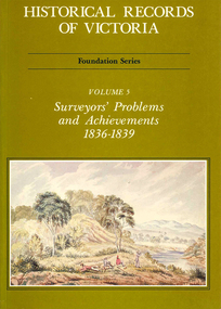
Book, Michael Cannon, Historical records of Victoria : foundation series : volume 5 : surveyors? problems and achievements 1836-1839, 1988
Reproductions of various transactions and reports dealing with the surveying history of Port Phillip, including letters, maps, illustrations, tables, and a detailed history of the surveying of Victoria.maps, b&w illustrations, b&w photographs, tablesvictorian history, port phillip, robert hoddle, monee monee creek, geelong, barwon river, werribee river -
 Sunshine and District Historical Society Incorporated
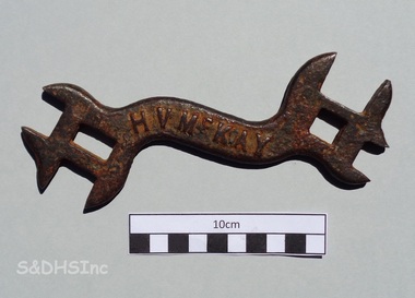
D324 WRENCH - H. V. McKay, H. V. McKay Pty. Ltd, Early 1900's
This type of wrench or spanner was used as a service tool for H. V. McKay Pty. Ltd. manufactured agricultural machinery. This specific tool belonged to Albert (Bert) Montgomery of 11 Kamarooka St, Albion. Bert Montgomery was born in Sunshine and in 1910 was apprenticed as a carpenter with Sunshine Harvester Works, where he worked as a wood machinist. On 19 August 1914, while still an apprentice, he enlisted in the First AIF. He left McKay's and started business as a builder probably just prior to WW2. After the war he joined the Shire of Braybrook as Assistant Building Surveyor until he retired. In 1962 Bert and his friend Jack Causon (proprietor of an Anderson Road second hand store that previously was Les James grocery) were on a fishing trip to Lake Tooliorook (aka Ettrick) near Lismore, Victoria. Their boat capsized and both fishermen were drowned. Bert was a Past President of Sunshine RSL and at that time it was reported that his funeral was the largest that Sunshine had seen. The information about Bert Montgomery was supplied by a Committee member of the Sunshine & District Historical Society Inc. who spoke to Montgomery's daughter, who also donated the tool. This tool serves as a reminder of the large H. V. McKay agricultural manufacturing works that once existed in Sunshine. The tool is associated with the works, and the design is significant enough for images of the tool to be used in an artistic mural, which is painted on the Eastern Pillar of the new H. V. McKay Footbridge in Sunshine, Victoria 3020.Curved double ended rusty cast iron wrench with 4 open slots plus 2 closed slots'H V McKAY' on one side and 'D324' on the reverse sideh. v. mckay pty. ltd, d324, d324 wrench, d324 spanner, agricultural spanner, antique wrench, agricultural tool, albert montgomery, jack causon, lake tooliorook -
Clunes Museum
Document - REPORTS
E J Dunn described the geology of the mining in an around Clunes and a recommendation for re-commencing mining operations in Clunes 1909.1 PHOTOCOPY OF A PAGE SHOWING RETURNS MADE BY MINING SURVEYORS AND REGISTERS TAKEN FOR THE QUARTER ENDED 31ST MARCH 1875 .2 & .3 PHOTOCOPY OF TWO PAGES OF A GEOLOGICAL SURVEY COMPLETED FOR THE GOVERNMENT (SENT IN 17/5/1909)NILlocal history, document, mining -
Koorie Heritage Trust
Book, Bonwick, James, Port Phillip settlement, 1883
... ; The surveyor's note-book and report; Life of Mr. Fawkner before 1835 ...Contents: Discovery; Mr. Grimes round the Bay, 1803; Settlement of 1803; The settlement of 1826; Hume and Hovell's overland journey; The Western Port settlement; Captain Sturt on the Murray; Portland Bay settlement in 1834; Major Mitchell's discoveries in Australia Felix; Life of John Batman; Batman's journal and report; The wild white man; The surveyor's note-book and report; Life of Mr. Fawkner before 1835; Fawkner on the Yarra Yarra; Official correspondence; The Port Phillip Association; Official recognition of trespassers; First Government of Port Phillip; Mr Gellibrand lost in the bush; The Governor's visit to the Yarra; Melbourne and its land sale; The stock question; Mr Mackillop's narrative; Progress of the settlement; The early Melbourne press; Discovery of Gipps Land; The Black Question; Narratives of Old Hands; Causes of emigration in 1835; An Overland journeyx, 537 pages, [36] leaves of plates (some folded.) illustrations (1 colour), facsimiles, portraits ; 23 cm.Contents: Discovery; Mr. Grimes round the Bay, 1803; Settlement of 1803; The settlement of 1826; Hume and Hovell's overland journey; The Western Port settlement; Captain Sturt on the Murray; Portland Bay settlement in 1834; Major Mitchell's discoveries in Australia Felix; Life of John Batman; Batman's journal and report; The wild white man; The surveyor's note-book and report; Life of Mr. Fawkner before 1835; Fawkner on the Yarra Yarra; Official correspondence; The Port Phillip Association; Official recognition of trespassers; First Government of Port Phillip; Mr Gellibrand lost in the bush; The Governor's visit to the Yarra; Melbourne and its land sale; The stock question; Mr Mackillop's narrative; Progress of the settlement; The early Melbourne press; Discovery of Gipps Land; The Black Question; Narratives of Old Hands; Causes of emigration in 1835; An Overland journeymelbourne (vic.) -- history -- to 1834. | melbourne (vic.) -- history -- 1834-1851. | port phillip bay region (vic.) -- history. -
 Whitehorse Historical Society Inc.
Essay - Report, Talk by Keith Patterson, 1/08/1967 12:00:00 AM
Paper delivered to Nunawading Historical SocietyPaper delivered to Nunawading Historical Society on Clement Hodgkinson, surveyor of Nunawading by Keith PattersonPaper delivered to Nunawading Historical Societyhodgkinson, clement, nunawading historical society, patterson, keith arthur, philosophical institute of victoria, surveyors -
 Ballarat Heritage Services
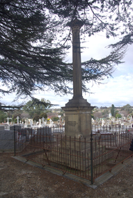
Photograph - Photograph - Colour, Burke and Wills Memorial at Bendigo Cemetery, 2018, 02/09/2018
Robert O'Hara Burke and Thomas Pope Besnard were childhood friends. As sexton of the local Back Creek Cemetery Thomas Besnard organised a subscription to raise the money for a monument to Burke, Wills and Gray. A subscription of one shilling, no more and not less, was asked so all subscribers were equal. The Bendigo monument was designed by Adam Duncan and features a Corinthian column mounted on a foundation stone, topped with a Grecian urn draped with the Union Jack. The stone for the monument was quarried from New Chum Mine. The site in the Bendigo Cemetery was selected by Besnard so the monument was on a grass knoll well clear of any other graves. The design included landscaping with a path and garden beds that provided dignified access. The Burke and Wills Monument in Bendigo has been entered on the Register of the National Estate as being important for its association with historical events and developments associated with exploration in the early days of Colony of Victoria. Two conifers remain from the original group sent by Mueller of the Melbourne Botanical Gardens to develop the garden layout on the knoll. These two trees are listed as Significant Trees by City of Greater Bendigo. The foundation block was laid on 20 August 1862 by Chairman of the Bendigo Municipality, Charles Burrows – exactly two years after the Expedition left Melbourne. A half day holiday was declared by Bendigo Council, and a procession left the Bendigo Town Hall and marched to the cemetery where 8000 people were gathered and another 4000 lined the route. John King was unable to attend due to ill health. Chairman of the Municipality of Bendigo, Charles Burrows, gave a long address, and diaries of members of the expedition, the Sandhurst Almanac, the Bendigo Advertiser, the Bendigo Independent Evening News, photographs of the deceased, photographs of Public Buildings in Bendigo, a Sydney half sovereign and all the silver coins of the Realm were wrapped in a Union Jack and placed in a niche in the foundation stone. Fifteen months later a column was erected on the foundation stone after Besnard openly criticised the Memorial Committee for their lack of action. The Bendigo Advertiser was disappointed at the location of the monument preferring a more central location and in 1893 an attempt was made to move the monument to Rosalind Park. On 19 May 1893, Mr Minto, the City Surveyor of the Bendigo MunicIpality reported it would cost £25, and no other action occurred. In 1940 the land around the memorial was sold off as grave sites and the paths and garden beds disappeared with graves now surrounding the base of the monument. The Burke and Wills Monument in Bendigo Cemetery was entered on the Register of the National Estate for its association with historical events and developments associated with exploration in the early days of Colony of Victoria. Two conifers remain from the original group sent by Mueller of the Melbourne Botanical Gardens to develop the garden layout on the knoll. These two trees are listed as Significant Trees by City of Greater Bendigo.Burke and Wills Memorial at Bendigo Cemetery, 2018Erected by the people of Bendigo in honor of the Victorian Explorers, Burke, Wills, Gray and King who first crossed the continent of Australia. King alone surviving the privation and suffering under which his three brave ill-fated companions sank. A.D. 1862. Robert O'Hara Burke, leader of the Victorian Expedition, left Melbounre 24th August 1860. Reached Carpentaria 12th Feby 1861. Died on his return at Coopers Creek, 30th June 1861. Charles Gray, died also on his return at Polygorum Swamp. 17th April 1861. William John Wills, second in command, died also near Coopers Creek, 29th June 1861. bendigo cemetery, burke and wills, burke and wills memorial, william john wills, john o'hara burke, charles gray, polygonum swamp, coopers creek, victorian expedition, carpentaria, bendigo public cemetery, bendigo remembrance park, thomas pope besnard -
 Bendigo Historical Society Inc.
Administrative record - Order for surveys and reports 1926-1940
Green cover book with brown leather spine. Orders for surveys or reports, under the following headings: nature of instructions, correspondence number, when returned. amount of survey fee, by whom paid, date of account passed, remarks. The following surveyors are used: William Archdall, Castlemaine - Garnet G. Birch, Bendigo - J.H. Brown, St. Arnaud - A.A. Briggs. Echuca - A.D. Thomson, Mildura - Tom Lowndes, Kerang - R.A. Black, Nyah West.survey, land, government -
 Bendigo Historical Society Inc.
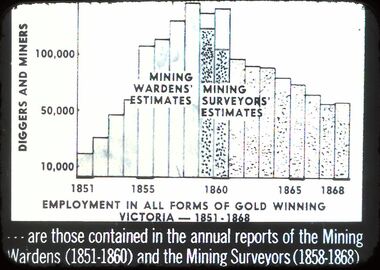
Slide - DIGGERS & MINING: DIGGERS & MINING
Diggers & Mining: Diggers & Mining. Graph depicts employment in all forms of gold winning Victoria (1851-1868) - - - - are these contained in the annual reports of the Mining Wardens (1851-1860 and the Mining Surveyors (1858-1868) Markings: 44/ 994:LIF 1. Used as a teaching aid.hanimounteducation, tertiary, diggers & miners -
![H.H. Harrison, Town Clerk [of Kew] 1901-1938](/media/collectors/550653872162f11fb04854aa/items/5922c035d0cde9131c3555a9/item-media/5c2269b021ea6913f4577219/item-fit-380x285.jpg) Kew Historical Society Inc
Kew Historical Society IncPhotograph, H.H. Harrison, Town Clerk [of Kew] 1901-1938, 1930s
Cr. W.D. Vaughan in his civic history of Kew includes a chapter (XXXII, pages 132-3) to Town Clerks and Surveyors. He states that H.H. Harrison began his career with the Borough of Kew in 1888 as his predecessor's assistant, becoming Town Clerk on the latter's death in 1901. On his retirement, The Herald on 30 Jul 1938 reported that: "H.H. HARRISON, Town Clerk of Kew, was entertained last night by members of the Metropolitan Institute of Town Clerks and presented with a walking stick and case of pipes, on the occasion of his retirement after 50 years' service with Kew City Council. He began his municipal career as a youth with the Bendigo City Council, and in 1888, was appointed Assistant Town Clerk at Kew. Appointed Town Clerk in 1901, he has held the office for 37 years."This portrait is one of a series of mounted and framed photographic portraits of Mayors and Town Clerks of the former Borough, Town and City of Kew, for the period 1863 to 1969. The portraits were transferred by the City of Kew to the Kew Historical Society in March 1989. A Significance Assessment in 2018, funded by the National Library of Australia confirmed the historic, and often artistic significance of the series. Framed portrait of Henry Hirst Harrison, Town Clerk of the City of Kew from 1901 to 1938. The mounting and framing of the photograph follows a typical layout or style in that it each is framed in dark wood, glazed, and laid down on an inscribed board. The inscription identifies the name of the town clerk and the year/s that he served.H.H. Harrison, Town Clerk 1901-1938h.h. harrison, town clerks - kew (vic), kew (vic.) — municipal collection -
Stawell Historical Society Inc
Archive, Mining Surveyor’s and Registrar’s Reports 1859-1871, 1859 - 1871
... grampians Stawell Mining None for year 1867 Mining Surveyor’s ...None for year 1867stawell, mining