Showing 67 items matching "ten mile"
-
 Flagstaff Hill Maritime Museum and Village
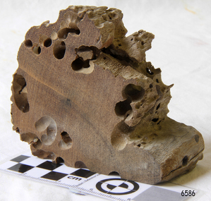
Memorabilia - Wood Sample, about 1871
The American wooden ship Eric the Red was named after the Icelandic Viking Eric 'the Red-Haired' Thorvaldsson, who was the first European to reach the shores of North America in 980 A.D. The ship Eric the Red was owned by the Sewall family of Bath, Maine, between 1873 and 1877 it operated in the coal trade between Britain and America. It then operated on the South American guano/ nitrates trade, before again trading between Europe and New York. On this voyage the Eric the Red had been chartered to carry a full cargo of American merchandise including many exhibits bound for the international exhibition to be held in Melbourne in 1880. Eighty-five days out from New York with 23 crew and two passengers, the Eric the Red approached Cape Otway nearing the end of its long voyage. At 1 am on 4 September the weather was hazy with a moderate north-westerly wind, Captain Jacques Allen had all sail set except for the mizzen-royal and the cross jack sails doing 8 knots, and was steering by the light to keep 5-6 miles offshore and clear of Otway Reef. Returning to the deck after consulting his charts the ship bumped as it ran onto the Otway Reef. It struck a second time and then a heavy sea carried away the wheel ropes and the man at the wheel. A third bump carried away the rudder, and shortly after this the ship completely broke up - within twelve minutes it had disappeared but for floating wreckage and cargo. Captain Jacques Allen recounted that: "The mizzen topmast fell with all the rigging, but strange to say, not a man was hurt by it, although they were all standing about. As soon as I found out there was no hope I said to Ned Sewell, the owner's son, and the third mate on board "Stick to me, and hang on to this mizzen mast". I peeled off everything I had on except my drawers thinking I would be able to swim better without my clothes; and Sewell and myself, clinging to the mast, were washed overboard...It was a fearful sea; I have never seen anything like it". Attempting to swim to a more substantial raft of wreckage, and losing touch with young Sewell in the process, Captain Allen struck out: " Just as I left the spar my drawers got down my legs, and entangled them, and down I went. I managed to clear one of my legs and on coming up I managed to get hold of some floating timber. There was a clear space of water between this timber and the deck, except for the spare royal yard, and I again started, but the surf struck me and I went over and over. I managed to get hold of the spare yard, and after holding on to it for some time I managed to get to the deck. When I was pulled on to it I could not move, being so numb and cramped with the cold. The men had some blankets and other things which they had got from the passengers' room in the deck house, and they wrapped me in these. Shortly after I got onto the wreck we made out the steamer's lights, and as soon as she was within hearing distance the men haled. This must have been about half-past four the Captain of the Dawn sent two of his boats to cruise about, and at daylight, they picked us up off the wreck. We had drifted about four miles from the reef where the ship struck, all those who were rescued were more or less bruised. One man had two or three ribs broken, and another had some fingers crushed off. My left foot is very much hurt, and I am black and blue from head to foot. I never knew such ten minutes as that of the wreck, and I thought the time had come for me to 'hand in my checks'. The ship was worth about £15,000, and neither it nor the freight was insured one dollar". (Argus 14/9/1880). Three of the crew and one of the passengers had been swept away and drowned. Fortunately for those clinging to the remains of the shattered hull and floating wreckage, the steamer SS Dawn passed close by and the crew heard the distressed cries of the survivors. Boats were lowered and the survivors were rescued. The Dawn stayed in the area for several hours searching for more survivors. One body was found washed up at Cape Otway and was buried in the lighthouse cemetery. The captain and crew of the Dawn later received rewards and thanks from the United States consul for their efforts. The hull and cargo were sold for £410, and large rafts of floating wreckage and cargo washed up all over the Victorian coast. A section of the hull lies buried in the sand at the Parker River beach, an anchor is on the rocks at Point Franklin, a second anchor is on display at the Cape Otway lighthouse and parts of the ship are on display at Bimbi Park and the Apollo Bay museum. Various wreckage is located in a concentration off Point Franklin, but suitable diving conditions are rare due to waves and strong currents. At the time of the wreck parts of its were salvaged and used in the construction of houses and sheds around Apollo Bay, including Milford House (since burnt down in bush fires), which had furniture and fittings from the ship, and the dining room floor made out of its timbers. A ketch the Apollo was also built from its timbers and subsequently used in Tasmanian waters.The Eric the Red is historically significant as one of Victoria's major 19th-century shipwrecks. The wreck led to the provision of an additional warning light placed below the Cape Otway lighthouse to alert mariners to the location of Otway Reef. The site is archaeologically significant for its remains of a large and varied cargo and ship's fittings being scattered over a wide area. The site is recreationally and aesthetically significant as it is one of the few sites along this coast where tourists can visit identifiable remains of a large wooden shipwreck and for its location set against the background of Cape Otway, Bass Strait, and the Cape Otway lighthouse. (Victorian Heritage Database Registration Number S 239, Official Number 8745 USA) Wood sample from the wreck of the ship Eric the Red the wood is dark in colour and is very light in weight. Noneflagstaff hill, warrnambool, shipwrecked-coast, flagstaff-hill, flagstaff-hill-maritime-museum, maritime-museum, shipwreck-coast, flagstaff-hill-maritime-village, shipwreck-artefact, eric-the-red, zaccheus-allen, sewall, 1880, melbourne-exhibition, cape-otway, otway-reef, wood-sample, s.s.-dawn -
 Federation University Historical Collection
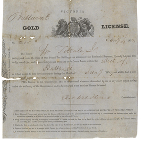
Gold License, Gold License made out to William Fittall Junior, 1853, 04/01/1853
This miner's right is a copy from an original held by the Old Colonists' Association of Ballarat. The original was glued onto a page in a large album of photographic images of early Ballarat. Recognising their significance the Council of the Old Colonists’ Association had them removed and restored. The originals are now framed and on display in the Old Colonists’ Hall.Digital copy of an original Gold Lisense made out to William Fittall Junior.Ballarat Victoria Gold License No. 215 Jany 4 1853 The Bearer Wm Fittale [sic] Jr having paid to me the Sum of One Pound Ten Shillings, on account of the territorial revenue, I hereby License him to dig, search for, and remove Gold on and from any such Crown lands within the Dist of Ballarat as I shall assign to him for that purpose during the month of January 1853 not within half-a-mile of any Head Station, This License is not transferable, and to be produced whenever demanded by me or any other person acting under the authority of the Government, and to be returned when another License is issued. Chas Wale Sherard Commissioner. Regulations to be observed by the persons digging for Gold or otherwise employed at the Gold fields. 1. Every licensed person must always have his License with him ready to be produced whenever demanded by a Commissioner, or Person acting under instructions, otherwise he is liable to be proceeded against as an unlicensed person. 2. Every person digging to Gold, or occupying Land, without a License is liable by law to be fined, for a first offence, not exceeding five pounds; for a second offence not exceeding 15 pounds; and for subsequent offence, not exceeding 30 pounds. 3. Digging for Gold is not allowed within ten feet of the edge of any Public Road, nor are the roads to be undermined. 4. Tents or Buildings are not to be erected within twenty feet of each other, or within 20 feet of any Creek 5. It is enjoined that all persons on the Gold Fields maintain a due and proper observance of Sundays. william fittall, sherard, charles sherard, charles wale sherard, mining, fittall, eureka -
 Bendigo Historical Society Inc.
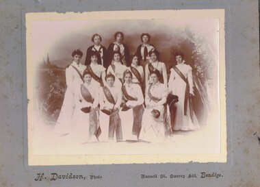
Photograph - GROUP OF WOMEN, EMPIRE DAY DRESS, 1910?
Sepia photograph on grey board. Ten females in long white dresses with long fringed sashes embossed with 'cead mile failte'. All have small Irish harps in hair and carry small black bags. Back row - three young girls with white tops and dark capes. Inscriptions: in image - on sashes 'cead mille failte'. Printed on board at bottom 'H Davidson, Photo, Russell Street, Quarry Hill, Bendigo'. On back - hand written in pencil. 'Empire Fair', 'Ireland', 'Mechanic's Institute'.H Davidson, Russell Street, Quarry Hillperson, group, women -
 Monbulk RSL Sub Branch
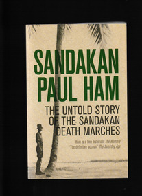
Book, William Heinemann, Sandakan : the untold story of the Sandakan Death Marches, 2013
The untold story of the Sandakan death marches of World War II. After the fall of Singapore, in February 1942, the Japanese conquerors rounded up tens of thousands of British and Australian soldiers and shipped them to prison camps scattered throughout Hirohito's newly won Empire. The fall of Britain's 'impregnable fortress' was the greatest humiliation in British military history, for which Churchill never forgave the Japanese. But nothing would surpass the wretched fate of some 2,700 British and Australian prisoners who were shipped to British North Borneo later that year. They landed in Sandakan, on the east coast of the island, after a 10-day voyage on a Japanese 'hell' ship, and were herded into a jungle camp some eight miles inland. Thus began the three-year ordeal of the Sandakan prisoners of war - a barely known story of unimaginable horror.Index, bibliography, notes, ill, p.688.non-fictionThe untold story of the Sandakan death marches of World War II. After the fall of Singapore, in February 1942, the Japanese conquerors rounded up tens of thousands of British and Australian soldiers and shipped them to prison camps scattered throughout Hirohito's newly won Empire. The fall of Britain's 'impregnable fortress' was the greatest humiliation in British military history, for which Churchill never forgave the Japanese. But nothing would surpass the wretched fate of some 2,700 British and Australian prisoners who were shipped to British North Borneo later that year. They landed in Sandakan, on the east coast of the island, after a 10-day voyage on a Japanese 'hell' ship, and were herded into a jungle camp some eight miles inland. Thus began the three-year ordeal of the Sandakan prisoners of war - a barely known story of unimaginable horror.world war 1939-1945 - prisoners of war - sandakan, japan - prisons and prisoners of war -
 National Vietnam Veterans Museum (NVVM)
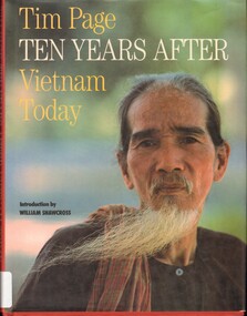
Book - Ten Years After Vietnam Today, Page, Tim, 1987
Long after the last spasm of the Vietnam War, the day tank no. 844 trundled through the Presidential gates in Saigon after a journey of over two throusand miles, the memories and experiences of this ferocious conflict continue to haunt a whole generation, East and West.non-fictionLong after the last spasm of the Vietnam War, the day tank no. 844 trundled through the Presidential gates in Saigon after a journey of over two throusand miles, the memories and experiences of this ferocious conflict continue to haunt a whole generation, East and West.vietnam, saigon -
 National Vietnam Veterans Museum (NVVM)
Book, Page, Tim, Ten Years After: Vietnam Today, 1987
Long after the last spasm of the Vietnam War, the day tank no. 844 trundled through the Presidential gates in Saigon after a journey of over two thousand miles, the memories and experiences of this ferocious conflict continue to haunt a whole generation, East and West.Long after the last spasm of the Vietnam War, the day tank no. 844 trundled through the Presidential gates in Saigon after a journey of over two thousand miles, the memories and experiences of this ferocious conflict continue to haunt a whole generation, East and West.vietnam - description and travel, vietnam - pictorial works -
 Uniting Church Archives - Synod of Victoria
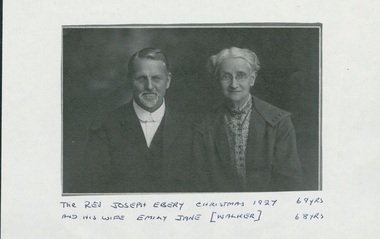
Photograph, Rev. Joseph Ebery and his wife Emily Jane (née Walker), Christmas 1927, 1927
Joseph Ebery was a Congregational minister, born 1858, died November 3, 1947. Ministry was as Wesleyan Home Missionary ?–1897; Congregational churches – Dover (Tas) 1897-1907; Tamar St Launceston 1907-1909; Devonport 1909-1914; Gatton (Qld) 1915-?; Redcliffe (Qld) 1921-1927; Beechworth (Vic) 1927-1930; Hughesdale 1930-1934. Was a Wesleyan lay preacher at Allandale and Woodbridge (Tas). Obituary - "… For ten years carried on an energetic evangelistic ministry, riding his horse over the roughtest roads in his scattered district, which was 25 miles long, and visiting even the southern-mosst home in the island (Tasmania)" As a Wesleyan Home Missionary he was not allowed to marry. The Congregationalists had no such restrictions so he joined the Congregational Church and married his Emily. [See Munster, Biographical Index of Congregational Ministers in Victoria 1838-1977.)Photocopy of studio portrait of Rev. Joseph Ebery and Mrs. Emily Jane (nee Walker) Ebery, Joseph aged 69 and Emily aged 68. Joseph, beard and moustache, is wearing a suit with a cellophane collar, no tie. Emily is earing a coat over a patterned shirt, and a choker necklace and glasses.As for the title.ebery, joseph, congregationalist, wesleyan home missionary, 1858-1947 -
 Yarrawonga and Mulwala Pioneer Museum
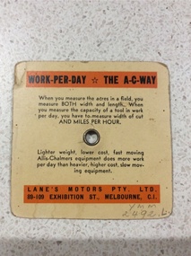
Tractor calculator, Unknown
A ready reckoner useful to the farmer during the 1950'sSquare orange card with rotating wheel attached by a centrre metal stud. By aligning appropriate measures on the wheel and card it tells the farmer the approx number of acres that can be worked in a ten hour day with any tool or implement.Allis Chambers tracotr calculator. Tractor speed miles per hour. Width of cut in feet of ploughs, harrows, cultivators, combines, harvesters etc (see photo) -
 Ballarat Heritage Services
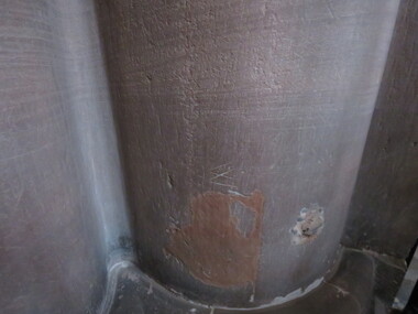
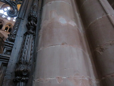
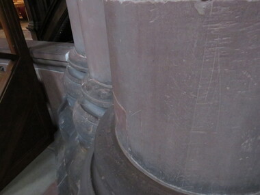
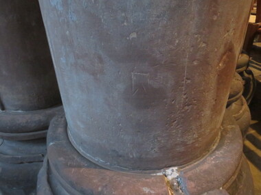
Photograph - Photograph - Colour, Dorothy Wickham, Mason's Marks, Carlisle Cathedral 27 October 2016, 2016
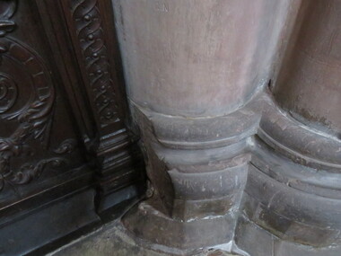
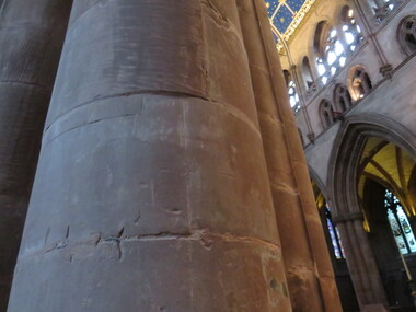
Carlisle Cathedral The Priory near the cathedral was founded in 1122 by King Henry I. There were earlier buildings on the site. Ten years later the priory church became the Cathedral and the Kind created the diocese of Carlisle. The building is constructed of red sandstone. Celebrated architect Ivo de Raughton who lived a few miles south of Carlisle designed the intricate masonry. Many interesting features are recorded about Carlisle Cathedral in tourist brochures and its homepage, however they do not mention the many mason’s marks clearly visible on the stone columns inside the Cathedral. There have been hundreds of marks recorded, some being similar to those on the Yarrowee Channel in Ballarat. mason's marks, carlisle, cathedral, stonemasons, mason's marks -
 Ballarat Heritage Services
Photograph - Colour, Dorothy Wickham, Mason's Marks, Carlisle Cathedral 27 October 2016, 2016
Carlisle Cathedral The Priory near the cathedral was founded in 1122 by King Henry I. There were earlier buildings on the site. Ten years later the priory church became the Cathedral and the Kind created the diocese of Carlisle. The building is constructed of red sandstone. Celebrated architect Ivo de Raughton who lived a few miles south of Carlisle designed the intricate masonry. Many interesting features are recorded about Carlisle Cathedral in tourist brochures and its homepage, however they do not mention the many mason’s marks clearly visible on the stone columns inside the Cathedral. There have been hundreds of marks recorded, some being similar to those on the Yarrowee Channel in Ballarat. carlisle, cathedral, stonemasons, mason's marks -
 Ballarat Heritage Services
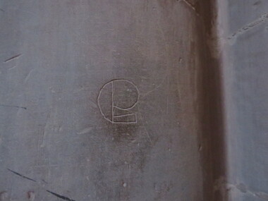
Photograph - Colour, Dorothy Wickham, Mason's Marks, Carlisle Cathedral 27 October 2016, 2016
Carlisle Cathedral The Priory near the cathedral was founded in 1122 by King Henry I. There were earlier buildings on the site. Ten years later the priory church became the Cathedral and the Kind created the diocese of Carlisle. The building is constructed of red sandstone. Celebrated architect Ivo de Raughton who lived a few miles south of Carlisle designed the intricate masonry. Many interesting features are recorded about Carlisle Cathedral in tourist brochures and its homepage, however they do not mention the many mason’s marks clearly visible on the stone columns inside the Cathedral. There have been hundreds of marks recorded, some being similar to those on the Yarrowee Channel in Ballarat. The sign of Thomas Crump, stonemasoncarlisle, cathedral, stonemasons, mason's marks, thomas crump, crump -
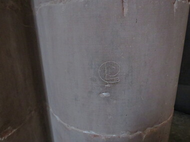 Ballarat Heritage Services
Photograph - Colour, Dorothy Wickham, Mason's Marks, Carlisle Cathedral 27 October 2016, 2016
Carlisle Cathedral The Priory near the cathedral was founded in 1122 by King Henry I. There were earlier buildings on the site. Ten years later the priory church became the Cathedral and the Kind created the diocese of Carlisle. The building is constructed of red sandstone. Celebrated architect Ivo de Raughton who lived a few miles south of Carlisle designed the intricate masonry. Many interesting features are recorded about Carlisle Cathedral in tourist brochures and its homepage, however they do not mention the many mason’s marks clearly visible on the stone columns inside the Cathedral. There have been hundreds of marks recorded, some being similar to those on the Yarrowee Channel in Ballarat. Sign of Thomas Crump, stonemasoncarlisle, cathedral, stonemasons, mason's marks, thomas crump, crump -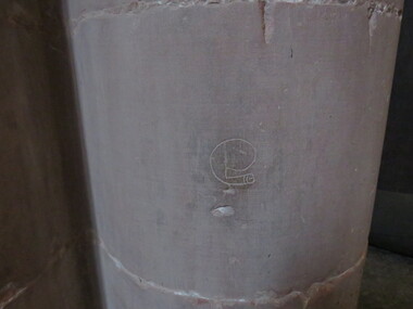
 Ballarat Heritage Services
Photograph - Colour, Dorothy Wickham, Mason's Marks, Carlisle Cathedral 27 October 2016, 2016
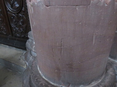
Carlisle Cathedral The Priory near the cathedral was founded in 1122 by King Henry I. There were earlier buildings on the site. Ten years later the priory church became the Cathedral and the Kind created the diocese of Carlisle. The building is constructed of red sandstone. Celebrated architect Ivo de Raughton who lived a few miles south of Carlisle designed the intricate masonry. Many interesting features are recorded about Carlisle Cathedral in tourist brochures and its homepage, however they do not mention the many mason’s marks clearly visible on the stone columns inside the Cathedral. There have been hundreds of marks recorded, some being similar to those on the Yarrowee Channel in Ballarat. Sign of the cross (plus sign)carlisle, cathedral, stonemasons, mason's marks -
 Ballarat Heritage Services
Photograph - Colour, Dorothy Wickham, Mason's Marks, Carlisle Cathedral 27 October 2016, 2016
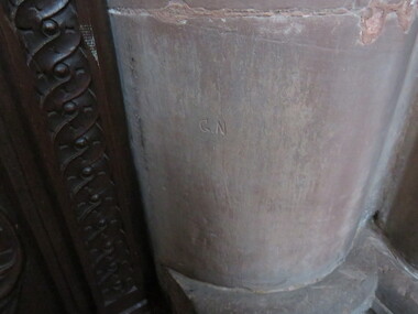
Carlisle Cathedral The Priory near the cathedral was founded in 1122 by King Henry I. There were earlier buildings on the site. Ten years later the priory church became the Cathedral and the Kind created the diocese of Carlisle. The building is constructed of red sandstone. Celebrated architect Ivo de Raughton who lived a few miles south of Carlisle designed the intricate masonry. Many interesting features are recorded about Carlisle Cathedral in tourist brochures and its homepage, however they do not mention the many mason’s marks clearly visible on the stone columns inside the Cathedral. There have been hundreds of marks recorded, some being similar to those on the Yarrowee Channel in Ballarat. Digital photographG. N.carlisle, cathedral, stonemasons, mason's marks -
 Ballarat Heritage Services
Photograph - Colour, Dorothy Wickham, Mason's Marks, Carlisle Cathedral 27 October 2016, 2016
Carlisle Cathedral The Priory near the cathedral was founded in 1122 by King Henry I. There were earlier buildings on the site. Ten years later the priory church became the Cathedral and the Kind created the diocese of Carlisle. The building is constructed of red sandstone. Celebrated architect Ivo de Raughton who lived a few miles south of Carlisle designed the intricate masonry. Many interesting features are recorded about Carlisle Cathedral in tourist brochures and its homepage, however they do not mention the many mason’s marks clearly visible on the stone columns inside the Cathedral. There have been hundreds of marks recorded, some being similar to those on the Yarrowee Channel in Ballarat. Digital photographG.N.carlisle, cathedral, stonemasons, mason's marks -
 Ballarat Heritage Services
Photograph - Colour, Dorothy Wickham, Mason's Marks, Carlisle Cathedral 27 October 2016, 2016
Carlisle Cathedral The Priory near the cathedral was founded in 1122 by King Henry I. There were earlier buildings on the site. Ten years later the priory church became the Cathedral and the Kind created the diocese of Carlisle. The building is constructed of red sandstone. Celebrated architect Ivo de Raughton who lived a few miles south of Carlisle designed the intricate masonry. Many interesting features are recorded about Carlisle Cathedral in tourist brochures and its homepage, however they do not mention the many mason’s marks clearly visible on the stone columns inside the Cathedral. There have been hundreds of marks recorded, some being similar to those on the Yarrowee Channel in Ballarat. Digital photographTwo "X" marks joined by a vertical linecarlisle, cathedral, stonemasons, mason's marks -
 Ballarat Heritage Services
Photograph - Colour, Dorothy Wickham, Mason's Marks, Carlisle Cathedral 27 October 2016, 2016
Carlisle Cathedral The Priory near the cathedral was founded in 1122 by King Henry I. There were earlier buildings on the site. Ten years later the priory church became the Cathedral and the Kind created the diocese of Carlisle. The building is constructed of red sandstone. Celebrated architect Ivo de Raughton who lived a few miles south of Carlisle designed the intricate masonry. Many interesting features are recorded about Carlisle Cathedral in tourist brochures and its homepage, however they do not mention the many mason’s marks clearly visible on the stone columns inside the Cathedral. There have been hundreds of marks recorded, some being similar to those on the Yarrowee Channel in Ballarat. Digital photographcarlisle, cathedral, stonemasons, mason's marks -
 Ballarat Heritage Services
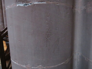
Photograph - Colour, Dorothy Wickham, Mason's Marks, Carlisle Cathedral 27 October 2016, 2016
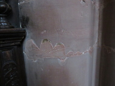
Carlisle Cathedral The Priory near the cathedral was founded in 1122 by King Henry I. There were earlier buildings on the site. Ten years later the priory church became the Cathedral and the Kind created the diocese of Carlisle. The building is constructed of red sandstone. Celebrated architect Ivo de Raughton who lived a few miles south of Carlisle designed the intricate masonry. Many interesting features are recorded about Carlisle Cathedral in tourist brochures and its homepage, however they do not mention the many mason’s marks clearly visible on the stone columns inside the Cathedral. There have been hundreds of marks recorded, some being similar to those on the Yarrowee Channel in Ballarat. A pentagram (sometimes known as a pentalpha, pentangle or star pentagon) is the shape of a five-pointed star. They were known as apotropaic or witch's marks and were thought to ward off evil spirits. Digital photographApotropaic mark carved into columncarlisle, cathedral, stonemasons, mason's marks, apotropaic mark, witch's mark -
 Ballarat Heritage Services
Photograph - Colour, Dorothy Wickham, Mason's Marks, Carlisle Cathedral 27 October 2016, 2016
Carlisle Cathedral The Priory near the cathedral was founded in 1122 by King Henry I. There were earlier buildings on the site. Ten years later the priory church became the Cathedral and the Kind created the diocese of Carlisle. The building is constructed of red sandstone. Celebrated architect Ivo de Raughton who lived a few miles south of Carlisle designed the intricate masonry. Many interesting features are recorded about Carlisle Cathedral in tourist brochures and its homepage, however they do not mention the many mason’s marks clearly visible on the stone columns inside the Cathedral. There have been hundreds of marks recorded, some being similar to those on the Yarrowee Channel in Ballarat. digital photographcarlisle, cathedral, stonemasons, mason's marks -
 Ballarat Heritage Services
Photograph - Colour, Dorothy Wickham, Mason's Marks, Carlisle Cathedral 27 October 2016, 2016
Carlisle Cathedral The Priory near the cathedral was founded in 1122 by King Henry I. There were earlier buildings on the site. Ten years later the priory church became the Cathedral and the Kind created the diocese of Carlisle. The building is constructed of red sandstone. Celebrated architect Ivo de Raughton who lived a few miles south of Carlisle designed the intricate masonry. Many interesting features are recorded about Carlisle Cathedral in tourist brochures and its homepage, however they do not mention the many mason’s marks clearly visible on the stone columns inside the Cathedral. There have been hundreds of marks recorded, some being similar to those on the Yarrowee Channel in Ballarat. Digital photographA square with a shape like a "W" at the bottomcarlisle, cathedral, stonemasons, mason's marks -
 Ballarat Heritage Services
Photograph - Colour, Dorothy Wickham, Mason's Marks, Carlisle Cathedral 27 October 2016, 2016
Carlisle Cathedral The Priory near the cathedral was founded in 1122 by King Henry I. There were earlier buildings on the site. Ten years later the priory church became the Cathedral and the Kind created the diocese of Carlisle. The building is constructed of red sandstone. Celebrated architect Ivo de Raughton who lived a few miles south of Carlisle designed the intricate masonry. Many interesting features are recorded about Carlisle Cathedral in tourist brochures and its homepage, however they do not mention the many mason’s marks clearly visible on the stone columns inside the Cathedral. There have been hundreds of marks recorded, some being similar to those on the Yarrowee Channel in Ballarat. Digital photographcarlisle, cathedral, stonemasons, mason's marks -
 Ballarat Heritage Services
Photograph - Colour, Dorothy Wickham, Mason's Marks, Carlisle Cathedral 27 October 2016, 2016
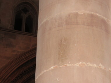
Carlisle Cathedral The Priory near the cathedral was founded in 1122 by King Henry I. There were earlier buildings on the site. Ten years later the priory church became the Cathedral and the Kind created the diocese of Carlisle. The building is constructed of red sandstone. Celebrated architect Ivo de Raughton who lived a few miles south of Carlisle designed the intricate masonry. Many interesting features are recorded about Carlisle Cathedral in tourist brochures and its homepage, however they do not mention the many mason’s marks clearly visible on the stone columns inside the Cathedral. There have been hundreds of marks recorded, some being similar to those on the Yarrowee Channel in Ballarat. Digital photographmonarch's head - wearing a crowncarlisle, cathedral, stonemasons, mason's marks -
 Old Colonists' Association of Ballarat Inc.
Document - Gold License, Gold License Issued to William Fittall in the Upper Loddon District, 1851, 10/1851
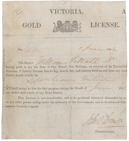
This miner's right is a copy from an original held by the Old Colonists' Association of Ballarat. The original was glued onto a page in a large album of photographic images of early Ballarat. Recognising their significance the Council of the Old Colonists’ Association had them removed and restored. The originals are now framed and on display in the Old Colonists’ Hall.Digital image of an original gold license made out to William Fittall Junior.14 Victoria Gold License No 144 1 June 1852 The Bearer William Fittall Jr having paid to me the sum of One Pound, Ten Shillings, on account of the territorial revenue, I hereby License him to dig, search for, and removed Gold on and from any such Crown lands within the Upper Loddon District as I shall assign to him for that purpose during the Month of June 1852 not within half-a-mile of any Head Station. This License is not transferrable, and to be produce whenever demanded by me or any other person acting under the authority of the government, and to be returned when another License is issued. [Undecipherable signature] Commissionerwilliam fittall, upper loddon, mining, old colonists' association, fittall, eureka -
 Old Colonists' Association of Ballarat Inc.
Document - Gold License, Gold License issued to John Chisholm
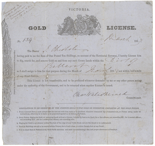
This miner's right was glued onto a page in a large album of photographic images of early Ballarat. Recognising their significance the Council of the Old Colonists’ Association of Ballarat Inc. had them removed and restored. The originals are now framed and on display in the Old Colonists’ Hall.Victorian Gold License made out to John Chisholm.Ballarat Victoria Gold License No. 139 March 1853 The Bearer J. Chisholm having paid to me the Sum of One Pound Ten Shillings, on account of the territorial revenue, I hereby License him to dig, search for, and remove Gold on and from any such Crown lands within the Dist of Ballarat as I shall assign to him for that purpose during the month of march 1853 not within half-a-mile of any Head Station, This License is not transferable, and to be produced whenever demanded by me or any other person acting under the authority of the Government, and to be returned when another License is issued. Chas Wale Sherard Commissioner. Regulations to be observed by the persons digging for Gold or otherwise employed at the Gold fields. 1. Every licensed person must always have his License with him ready to be produced whenever demanded by a Commissioner, or Person acting under instructions, otherwise he is liable to be proceeded against as an unlicensed person. 2. Every person digging to Gold, or occupying Land, without a License is liable by law to be fined, for a first offence, not exceeding five pounds; for a second offence not exceeding 15 pounds; and for subsequent offence, not exceeding 30 pounds. 3. Digging for Gold is not allowed within ten feet of the edge of any Public Road, nor are the roads to be undermined. 4. Tents or Buildings are not to be erected within twenty feet of each other, or within 20 feet of any Creek 5. It is enjoined that all persons on the Gold Fields maintain a due and proper observance of Sundays. Handwritten in top left corner 'Presented by D.M.D. Main. 12 Dundas St. Dunedin N.Z. 30.8.21chisholm, sherard, charles sherard, john chisholm, mining, main, d.m.d. main -
 City of Greater Bendigo - Civic Collection
Instrument - Gunter Chain, not known
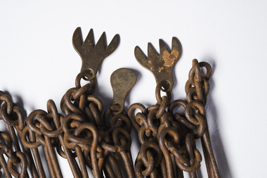
Gunter's chain (also known as Gunter’s measurement) is a distance measuring device used for surveying. It was designed and introduced in 1620 by English clergyman and mathematician Edmund Gunter (1581–1626). It enabled plots of land to be accurately surveyed and plotted, for legal and commercial purposes. The provenance of this particular Gunter Chain is unknown but it is believed to be used either by the City of Bendigo / Sandhurst or the Lands Department locally when measuring and laying out plots and streets locally. A 66-foot (20.1 m) chain divided into 100 links, marked off into groups of 10 by brass rings or tags. Each link is 7.92 inches (201 mm) long. A quarter chain, or 25 links, measures 16 feet 6 inches (5.03 m) also called a a rod (or pole) measure. Ten chains measure a furlong and 80 chains measure a statute mile. city of greater bendigo surveying -
 Victorian Harness Racing Heritage Collection at Lord's Raceway Bendigo
Photograph - Framed photo finish, Greg Matthews Photo, Knight Rainbow, 20 January 1995
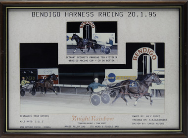
Knight Rainbow won the Bendigo Pacing Cup on the 20 January 1995, followed by Magic Fella and Its Nero's Fiddle. Knight Rainbow owned by Mr C Price, was trained by NR Alexander and driven by Chris Alford. Knight Rainbow raced from 1992 (2yo) through to 1997 (7yo). Career: 22 wins 8 seconds 8 thirds 85 starts.Two colour photographs, one small one large in a brown, black, gold frame. At the top: Bendigo Harness Racing 20-1-95/ Jetport Security Parking Ten Victoria Bendigo Pacing Cup / C9 or Better At the bottom: Left corner: Distance 2700 metres/ Mile rate 2.01.2 / Greg Matthews Photos - Stawell Centre: Knight Rainbow (Tuapeka Knight - Tina Scott) / Magic Fella 2nd / Its Nero's Fiddle 3rd Right corner: Owned by- Mr C Price/ Trained by NR Alexander / Driven by Chris Alfordbendigo harness racing club, horses, race, winner, bendigo trotting club, pacing cup, driver, trainer, owner, 1995, knight rainbow, nr alexander, chris alford, mr c price, magic fella, its nero's fiddle, ca alford -
 Victorian Harness Racing Heritage Collection at Lord's Raceway Bendigo
Photograph - Framed photo finish, Greg Matthews Photo, Brabham, 26 January 1996
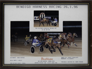
Brabham won the Bendigo Pacing Cup on the 26 January 1996, followed by Jamyan Prince and Ricky Dean. Brabham owned by Runvs Syndicate, Manager RW Death, was trained and driven by Mark Purdon. Brabham raced from 1994 (3yo) through to 2000 (9yo). Career: 20 wins 19 seconds 9 thirds 79 starts.Two colour photographs, one small one large in a brown, black, gold frame. At the top: Bendigo Harness Racing 26-1-96/ Ten Victoria Bendigo Pacing Cup / C9 or Better At the bottom: Left corner: Distance 2400 metres/ Mile rate 2.00.5 / Greg Matthews Photos - Stawell Centre: Brabham (New York Motoring - Armbro Speed) / Jamyan Prince 2nd / Ricky Dean 3rd Right corner: Owned by- Runvs Syndicate - Manager RW Death/ Trained and driven by Mark Purdonbendigo harness racing club, horses, race, winner, bendigo trotting club, pacing cup, driver, trainer, owner, 1996, brabham, mark purdon, runvs syndicate, jamyan prince, ricky dean, m purdon -
 Eltham District Historical Society Inc
Photograph - Digital Photograph, Marguerite Marshall, Eltham Lower Park, 20 April 2008
... in charge of the Eltham Police Station, Miles S Lyons. Another ten... in charge of the Eltham Police Station, Miles S Lyons. Another ten ...Originally a race course, the park has brought the community together with a variety of activities. Published: Nillumbik Now and Then / Marguerite Marshall 2008; photographs Alan King with Marguerite Marshall.; p45 Once used for horse racing, which attracted visitors from Melbourne, the Eltham Lower Park has brought the community together with a wide range of activities. Horse riding is now enjoyed as a recreation in the park as are other sports. The park also includes the Diamond Valley Railway miniature trains and a sanctuary for the rare and vulnerable Eltham Copper Butterfly. Eltham Lower Park, with other parks, forms an almost continuous green band from Eltham’s centre, along the Diamond Creek to the Yarra River.1 Before European settlement the Wurundjeri people met on this land, particularly at the junction of the Diamond Creek with the Yarra River, which they called Birr-arung. This is commemorated by the sculpture, Not just a Pretty Place by Aleks Danko, winner of the 2000 Nillumbik Art in Public Places Award. The first European to settle here was probably Henry Foley, who in 1841 used it as part of his pastoral run. Foley sold his leasehold to Joseph Wilson in 1845, who soon after sold it to Frederick Falkiner. During the 1840s the future park was part of a government square mile (2.6 sqkm) reserve, north of the Yarra, within the Parish of Nillumbik, later named Eltham. Soon the land was used for horse racing after nearby residents cleared ten acres (4ha) in the early 1850s. A three-quarter of a mile (1.2km) race secured the winner the £10 Publican’s Prize. In response to popular demand, the newly formed Eltham District Road Board petitioned the Surveyor General of the Colony of Victoria, in 1856, for 36 acres (14.6ha) of crown land for a racecourse and recreation. By 1858 the Eltham races had become an institution. ‘Many skirmishes occurred and the way home was paved with temptation, with sly-grog for sale.3 In the early 1870s, two jockeys were sons of the police officer in charge of the Eltham Police Station, Miles S Lyons. Another ten acres (4ha) was added to the area in 1866 and 12 acres (4.8ha) – Hohnes Hill – in 1870. In 1866, two acres (0.8ha) on the creek banks became an animal pound with William Walsh the pound keeper in 1870, but this was later incorporated into the park. By 1877 the area was called a public park but horse racing and training continued into the 1920s. In the mid-1900s trotters were trained on a circuit road. In 1953 the Eltham Pony Club was established and used a cross-country course on Hohnes Hill. From the mid 1950s the club held the Eltham Easter Fair at the park, later to include a procession along Main Road from the town centre to the park. The park also attracted picnic parties and campers from the inner suburbs as did Wingrove Park, and businesses catering for visitors, sprang up on the opposite side of Main Road. Bus-loads of school children visited the park for Gould League bird days in the 1960s. In 1979 the Eltham Shire Council bought Lenister Farm, linking the park with the Yarra River. The Lenister Farm wetland includes a bird hide, viewing platform and interpretive signs.5 Pioneer Henry Stooke, later Road Board chairman, bought the 11 acres (4.5ha) - later to become Lenister Farm - from the Crown in 1862. Stooke never lived on this site and the two houses at Lenister Farm were built in the 20th century. Since its formation in 1871, the Council has controlled this crown land, which it named Eltham Park. But in the 1920s Eltham Council bought land near the town centre for a park, which it named Eltham Central Park. To avoid confusion the Council renamed Eltham Park, Eltham Lower Park. Since 2004 the Yarra footbridge has linked the park with the Yarra Valley Metropolitan Park and the Main Yarra Trail.This collection of almost 130 photos about places and people within the Shire of Nillumbik, an urban and rural municipality in Melbourne's north, contributes to an understanding of the history of the Shire. Published in 2008 immediately prior to the Black Saturday bushfires of February 7, 2009, it documents sites that were impacted, and in some cases destroyed by the fires. It includes photographs taken especially for the publication, creating a unique time capsule representing the Shire in the early 21st century. It remains the most recent comprehenesive publication devoted to the Shire's history connecting local residents to the past. nillumbik now and then (marshall-king) collection, eltham lower park, eltham park -
 Eltham District Historical Society Inc
Photograph - Digital Photograph, Alan King, Kangaroo Ground Presbyterian Church, 28 December 2007
Built in 1878, the orange polychromatic brick structure replaced a slab building which had been used since 1951. The building has changed little with its handsome bricks buttressed on both sides, a slate roof and a Celtic cross on top of the front gable. The carved wooden pulpit and 18 pews are original. The cathedral-style ceiling is fully lined with tongue-and-groove pine boards and the floor is also pine. The walls have arched oblong leadlight windows. In 1977 the congregaton decided not to join the Uniting Church, whcih amalgamated some Presbyterian churches with all the Methodist and Congregational churches in Australia. Together with the store and school, the church is one of Kangaroo Ground's three public buildings. Covered under Heritage Overlay, Nillumbik Planning Scheme. Published: Nillumbik Now and Then / Marguerite Marshall 2008; photographs Alan King with Marguerite Marshall.; p91 The small Presbyterian church in Main Road, Kangaroo Ground, has been a spiritual centre for more than a century. Built in 1878, the orange polychromatic brick structure replaced a rude slab building, which had been used as both a church and school since 1851. Earliest settlers, who were Scottish farmers, had worshipped together since 1841 in a barn owned by farmer James Donaldson and led by a layman called Smith.1 However, from 1843, the Reverend Peter Gunn conducted church services. Prominent early church members include the Donaldson, Bell and Cameron families. In 1851, Samuel Furphy (father of author Joseph) built their first church building, a 30 feet x 18 feet (9m x 5.5m) slab structure on half an acre (0.2ha) donated by Mr Donaldson. Conditions could be very uncomfortable in extreme weather.The green slabs of timber and sapling logs, covered partly with mud, had centimetre-wide cracks, allowing rain and wind through, when not blocked out by folds of paper.2 However this did not deter the first couple marrying there in 1857: John Wilson of Nillumbik and Christina Macpherson of Christmas Hills. The Reverend Peter Gunn seldom visited so it was usually left to Andrew Ross, the settlement’s first teacher and founder of the newspaper The Evelyn Observer, to lead the divine services instead.3 In 1877 the settlers raised £355/19/- and hired architect, Charles Maplestone and builder, Mr Self, to construct today’s church building. Each family rented a pew or pews for ten shillings a half-year; they also paid quarterly subscriptions for the minister’s stipend.4 It was not until 1886 that the church celebrated its first wedding, that of John Bell (junior) from Violet Bank and Elizabeth Charlton of Cunis Nillen. The Sunday School’s first recorded meeting was also held that year. In 1892 a weatherboard vestry was built, and the following year John Bell donated a church bell, which the fire brigade used as a warning for several years. Conditions have varied greatly during the century. In 1893 the Reverend Darroch had to travel more than 2000 miles (3220km) to attend to his scattered parishioners. Then in the Depression, the minister Mr Brown, subsisted only on lodgings with no stipend. The Sunday School ceased for many years because of the small population, but reopened in 1949. The building has changed little with its handmade bricks buttressed on both long sides, a slate roof and a Celtic cross on top of the front gable. The carved wooden pulpit and 18 pews are original and in fine condition. The cathedral-style ceiling is fully lined with tongue-and-groove pine boards and the floor is also of pine. The walls have arched oblong leadlight windows. One window has stained glass commemorating Mrs Jessie Agnes Cameron and her ancestors – the pioneering Bell family. It depicts The Sower because the family comprised farmers who came to a strange land to sow the seeds of their faith as much as their crops. Thistles signify their Scottish ancestry and the pigeons are a symbol of Pigeon Bank, the Kangaroo Ground farming property where Jessie Cameron was born.5 Other historical ties are seen on two marble memorial tablets and carved wooden chairs dedicated to former members. The Church still has the original Bible with gold edged paper, presented by the women of the congregation in 1871, although it is no longer used. In 1977 the Presbyterian congregation decided not to join the Uniting Church, which amalgamated some Presbyterian churches with all the Methodist and Congregational churches in Australia. Together with the store and school, the church is one of Kangaroo Ground’s three public buildings.This collection of almost 130 photos about places and people within the Shire of Nillumbik, an urban and rural municipality in Melbourne's north, contributes to an understanding of the history of the Shire. Published in 2008 immediately prior to the Black Saturday bushfires of February 7, 2009, it documents sites that were impacted, and in some cases destroyed by the fires. It includes photographs taken especially for the publication, creating a unique time capsule representing the Shire in the early 21st century. It remains the most recent comprehenesive publication devoted to the Shire's history connecting local residents to the past. nillumbik now and then (marshall-king) collection, kangaroo ground presbyterian church