Showing 210 items
matching transport freeways
-
 Melbourne Tram Museum
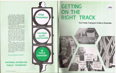
Book, Friends of the Earth, "Getting on the Right Track - The public transport crisis in Australia", mid to late 1970's
Book - 104 pages printed on newsprint, stapled with two colour light card cover, titled "Getting on the Right Track - The public transport crisis in Australia". Produced by the National Action for Public Transport, largely transport union based (see page 104 for contacts), looking at the lack of investment into public transport and the construction of freeways, roads and the growth of motor cars. Has a table of contents and many sketches, cartoons and tables. See inside front cover for sources, names and who produced the document, Friends of the Earth. Appears to have been produced mid to late 1970's. Two copies held.Has a "$1.50" Angus and Robertson price sticker on the front cover, top right hand corner.trams, tramways, public transport, unions, motor vehicles, road transport -
 Melbourne Tram Museum
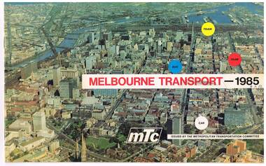
Pamphlet, Melbourne Transportation Committee, "Melbourne Transport 1985", c1971
Pamphlet, full colour, 14 pages (was 16 pages - one set has been removed or torn out) titled "Melbourne Transport 1985", reporting on the Melbourne Transportation Committee work, c1971. The document gives a summary of the recommendations of the Committee's planning for Melbourne transport for 1985, including the rail loop, proposed freeways and interchange facilities. Includes detailed planning for the Eastern Freeway, South Eastern Freeway and the Tullamarine Freeway. Showed some rail line extensions.On front cover in ink "4A12" and inside on page 3, "AETA" stamp in purple ink.trams, tramways, melbourne, transportation, planning -
 Melbourne Tram Museum
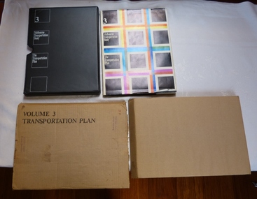
Document - Report, The Metropolitan Transportation Committee, "Melbourne Transportation Study - The Transportation Plan - Volume 3", 1969
Report titled "Melbourne Transportation Study - The Transportation Plan - Volume 3", presented in a black vinyl covered slip case, paper cover, bound, sewn with end papers, fold out maps, 74 pages. Each sheet within the report has rounded edges. Contained within a printed cardboard packing case. Includes many tables, graphs, charts and coloured sheets. Report prepared by The Metropolitan Transportation Committee - 1969, looking at the planning of all forms of transport for Melbourne with a timeframe of 1985. Chaired by Vernon Wilcox, Minister of Transport. Included Robert Risson - Chairman of MMTB. Set the basis for a very extensive freeway system that was only partly followed. Includes trams, trains (city loop), buses, parking, travel and population predictions, costs and implementation.Has numerous AETA stamps throughout the book. Inside front cover and on packing case "A12" in red ink.trams, tramways, melbourne, road transport, tramways, railways, public transport, transportation plan -
 Kew Historical Society Inc
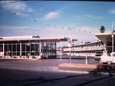
Photograph - California Motel, Barkers Road, Ron Setford, 1961
Ron Setford and his wife Grace Setford lived in Tanner Avenue, East Kew, from c.1946 to c.1995. A keen photographer, he recorded the changing face of Kew over a 20 year period. Apart from 30 photographs of built structures and places in Kew dating from 1960 and 1961, 145 of his 35mm colour slides chronicle the development of the Eastern Freeway through the Yarra Valley over a five year period from c.1972 to c.1977. This important collection was donated to the Society by his granddaughter in 2025.This collection of 175 35mm slides is of local and statewide significance, owing to its subject matter, particularly the major development of road transport infrastructure during the 1970s with the construction of the Eastern Freeway. The photographer also took care to annotate and date most of his slides which enable the researcher to pinpoint temporal and spatial locations.Opened in 1960, the California Motel at 138 Barkers Road, Hawthorn, was located opposite the entrance to Xavier College and built on the site of the former Barker railway station of the closed Kew branch line. The motel was advertised as “away from the hustle and bustle of the city and offering affordable accommodation for the business or leisure traveller”. Special amenities included air-conditioning, a business centre, and swimming pool. The motel had 82 suites. A possibly forgotten, but perhaps essential feature of the motel, was the Caltex Service Station at its entrance. The building was closed in April 2008, extensively vandalised and finally demolished in 2013."California Motel"ron setford, photographs -- kew (vic.) -- 1960s, california motel -- barkers road -- hawthorn (vic.) -
 Kew Historical Society Inc
Photograph - Yarra Street, Kew, Ron Setford, 1960
Ron Setford and his wife Grace Setford lived in Tanner Avenue, East Kew, from c.1946 to c.1995. A keen photographer, he recorded the changing face of Kew over a 20 year period. Apart from 30 photographs of built structures and places in Kew dating from 1960 and 1961, 145 of his 35mm colour slides chronicle the development of the Eastern Freeway through the Yarra Valley over a five year period from c.1972 to c.1977. This important collection was donated to the Society by his granddaughter in 2025.This collection of 175 35mm slides is of local and statewide significance, owing to its subject matter, particularly the major development of road transport infrastructure during the 1970s with the construction of the Eastern Freeway. The photographer also took care to annotate and date most of his slides which enable the researcher to pinpoint temporal and spatial locations.Yarra Street was not made a trafficable thoroughfare until October 1956. Until then, the gully was used as a dump, a shortcut to the river, and for communal Guy Fawkes night bonfires. The open landscape in the photo reflects near-total clearing by the original estate owners for grazing livestock. Post-war homes fronting Stawell St dot the landscape. Of particular note are the Broons House (c.1952–54) by Anatol Kagan (top right), and the homes of two architects, Kurt Elsner (c.1950) (middle) and Geoffrey Danne (c.1954) (lower right). Dual carriageways made blocks accessible, but building was difficult due to steeply sloping land and complex drainage easements. Nevertheless, these challenges resulted in highly innovative designs, making Yarra Street the core of the Yarra Boulevard Heritage Precinct."Yarra St Kew"ron setford, photographs -- kew (vic.) -- 1960s, yarra street -- kew (vic.) -
 Kew Historical Society Inc
Photograph - California Motel, Barkers Road, Kew, Ron Setford, 1961
Ron Setford and his wife Grace Setford lived in Tanner Avenue, East Kew, from c.1946 to c.1995. A keen photographer, he recorded the changing face of Kew over a 20 year period. Apart from 30 photographs of built structures and places in Kew dating from 1960 and 1961, 145 of his 35mm colour slides chronicle the development of the Eastern Freeway through the Yarra Valley over a five year period from c.1972 to c.1977. This important collection was donated to the Society by his granddaughter in 2025.This collection of 175 35mm slides is of local and statewide significance, owing to its subject matter, particularly the major development of road transport infrastructure during the 1970s with the construction of the Eastern Freeway. The photographer also took care to annotate and date most of his slides which enable the researcher to pinpoint temporal and spatial locations.Opened in 1960, the California Motel at 138 Barkers Road, Hawthorn, was located opposite the entrance to Xavier College and built on the site of the former Barker railway station of the closed Kew branch line. The motel was advertised as “away from the hustle and bustle of the city and offering affordable accommodation for the business or leisure traveller”. Special amenities included air-conditioning, a business centre, and swimming pool. The motel had 82 suites. A possibly forgotten, but perhaps essential feature of the motel, was the Caltex Service Station at its entrance. The building was closed in April 2008, extensively vandalised and finally demolished in 2013.Nilron setford, photographs -- kew (vic.) -- 1960s, california hotel -- barkers road -- hawthorn (vic.), california motel -- barkers road -
 Kew Historical Society Inc
Photograph - Kew Civic Offices, Ron Setford, 1973
Ron Setford and his wife Grace Setford lived in Tanner Avenue, East Kew, from c.1946 to c.1995. A keen photographer, he recorded the changing face of Kew over a 20 year period. Apart from 30 photographs of built structures and places in Kew dating from 1960 and 1961, 145 of his 35mm colour slides chronicle the development of the Eastern Freeway through the Yarra Valley over a five year period from c.1972 to c.1977. This important collection was donated to the Society by his granddaughter in 2025.This collection of 175 35mm slides is of local and statewide significance, owing to its subject matter, particularly the major development of road transport infrastructure during the 1970s with the construction of the Eastern Freeway. The photographer also took care to annotate and date most of his slides which enable the researcher to pinpoint temporal and spatial locations."Kew - "Taj-Mahal" / Cotham Rd - Charles St / Oct 73"ron setford, kew civic offices -
 Kew Historical Society Inc
Photograph - Kew Civic Offices, Ron Setford, 1973
Ron Setford and his wife Grace Setford lived in Tanner Avenue, East Kew, from c.1946 to c.1995. A keen photographer, he recorded the changing face of Kew over a 20 year period. Apart from 30 photographs of built structures and places in Kew dating from 1960 and 1961, 145 of his 35mm colour slides chronicle the development of the Eastern Freeway through the Yarra Valley over a five year period from c.1972 to c.1977. This important collection was donated to the Society by his granddaughter in 2025.This collection of 175 35mm slides is of local and statewide significance, owing to its subject matter, particularly the major development of road transport infrastructure during the 1970s with the construction of the Eastern Freeway. The photographer also took care to annotate and date most of his slides which enable the researcher to pinpoint temporal and spatial locations."Kew Taj-Mahal"ron setford, kew civic offices -
 Kew Historical Society Inc
Photograph - Kew Civic Offices, Ron Setford, 1973
Ron Setford and his wife Grace Setford lived in Tanner Avenue, East Kew, from c.1946 to c.1995. A keen photographer, he recorded the changing face of Kew over a 20 year period. Apart from 30 photographs of built structures and places in Kew dating from 1960 and 1961, 145 of his 35mm colour slides chronicle the development of the Eastern Freeway through the Yarra Valley over a five year period from c.1972 to c.1977. This important collection was donated to the Society by his granddaughter in 2025.This collection of 175 35mm slides is of local and statewide significance, owing to its subject matter, particularly the major development of road transport infrastructure during the 1970s with the construction of the Eastern Freeway. The photographer also took care to annotate and date most of his slides which enable the researcher to pinpoint temporal and spatial locations."Kew Council Offices"ron setford, kew civic offices -
 Kew Historical Society Inc
Photograph - Kew Civic Offices, Ron Setford, 1973
Ron Setford and his wife Grace Setford lived in Tanner Avenue, East Kew, from c.1946 to c.1995. A keen photographer, he recorded the changing face of Kew over a 20 year period. Apart from 30 photographs of built structures and places in Kew dating from 1960 and 1961, 145 of his 35mm colour slides chronicle the development of the Eastern Freeway through the Yarra Valley over a five year period from c.1972 to c.1977. This important collection was donated to the Society by his granddaughter in 2025.This collection of 175 35mm slides is of local and statewide significance, owing to its subject matter, particularly the major development of road transport infrastructure during the 1970s with the construction of the Eastern Freeway. The photographer also took care to annotate and date most of his slides which enable the researcher to pinpoint temporal and spatial locations."The "Taj-Mahal" / $1.250.000 Council Offices (we have to pay for it)"ron setford, photographs -- kew (vic.) -- 1960s, kew civic offices, kew town hall -
 Kew Historical Society Inc
Photograph - Kew Civic Hall and World War II War Memorial, Ron Setford, 1960
Ron Setford and his wife Grace Setford lived in Tanner Avenue, East Kew, from c.1946 to c.1995. A keen photographer, he recorded the changing face of Kew over a 20 year period. Apart from 30 photographs of built structures and places in Kew dating from 1960 and 1961, 145 of his 35mm colour slides chronicle the development of the Eastern Freeway through the Yarra Valley over a five year period from c.1972 to c.1977. This important collection was donated to the Society by his granddaughter in 2025.This collection of 175 35mm slides is of local and statewide significance, owing to its subject matter, particularly the major development of road transport infrastructure during the 1970s with the construction of the Eastern Freeway. The photographer also took care to annotate and date most of his slides which enable the researcher to pinpoint temporal and spatial locations."Kew Town Hall"ron setford, photographs -- kew (vic.) -- 1960s, kew town hall -
 Kew Historical Society Inc
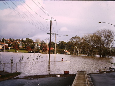
Photograph - Flooding, Kilby Road, Kew, Ron Setford, 1974
Ron Setford and his wife Grace Setford lived in Tanner Avenue, East Kew, from c.1946 to c.1995. A keen photographer, he recorded the changing face of Kew over a 20 year period. Apart from 30 photographs of built structures and places in Kew dating from 1960 and 1961, 145 of his 35mm colour slides chronicle the development of the Eastern Freeway through the Yarra Valley over a five year period from c.1972 to c.1977. This important collection was donated to the Society by his granddaughter in 2025.This collection of 175 35mm slides is of local and statewide significance, owing to its subject matter, particularly the major development of road transport infrastructure during the 1970s with the construction of the Eastern Freeway. The photographer also took care to annotate and date most of his slides which enable the researcher to pinpoint temporal and spatial locations."Flood Kilby Road / May 74"ron setford, floods -- kew (vic.), kilby road -- kew (vic.) -
 Kew Historical Society Inc
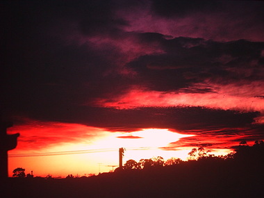
Photograph - Sunrise over Kew East, Ron Setford, 1969
Ron Setford and his wife Grace Setford lived in Tanner Avenue, East Kew, from c.1946 to c.1995. A keen photographer, he recorded the changing face of Kew over a 20 year period. Apart from 30 photographs of built structures and places in Kew dating from 1960 and 1961, 145 of his 35mm colour slides chronicle the development of the Eastern Freeway through the Yarra Valley over a five year period from c.1972 to c.1977. This important collection was donated to the Society by his granddaughter in 2025.This collection of 175 35mm slides is of local and statewide significance, owing to its subject matter, particularly the major development of road transport infrastructure during the 1970s with the construction of the Eastern Freeway. The photographer also took care to annotate and date most of his slides which enable the researcher to pinpoint temporal and spatial locations."Sunrise over East Kew [Aug69}"ron setford, photographs -- kew (vic.) -- 1960s, kew east -
 Kew Historical Society Inc
Photograph - Kew Bowling Club -- Wellington Street (Kew), Ron Setford
Ron Setford and his wife Grace Setford lived in Tanner Avenue, East Kew, from c.1946 to c.1995. A keen photographer, he recorded the changing face of Kew over a 20 year period. Apart from 30 photographs of built structures and places in Kew dating from 1960 and 1961, 145 of his 35mm colour slides chronicle the development of the Eastern Freeway through the Yarra Valley over a five year period from c.1972 to c.1977. This important collection was donated to the Society by his granddaughter in 2025.This collection of 175 35mm slides is of local and statewide significance, owing to its subject matter, particularly the major development of road transport infrastructure during the 1970s with the construction of the Eastern Freeway. The photographer also took care to annotate and date most of his slides which enable the researcher to pinpoint temporal and spatial locations.Nilron setford, kew bowling club, wellington street -- kew (vic.), sport and recreation -- kew (vic.) -
 Kew Historical Society Inc
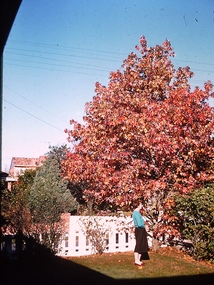
Photograph - Liquid Amber, Ron Setford
Ron Setford and his wife Grace Setford lived in Tanner Avenue, East Kew, from c.1946 to c.1995. A keen photographer, he recorded the changing face of Kew over a 20 year period. Apart from 30 photographs of built structures and places in Kew dating from 1960 and 1961, 145 of his 35mm colour slides chronicle the development of the Eastern Freeway through the Yarra Valley over a five year period from c.1972 to c.1977. This important collection was donated to the Society by his granddaughter in 2025.This collection of 175 35mm slides is of local and statewide significance, owing to its subject matter, particularly the major development of road transport infrastructure during the 1970s with the construction of the Eastern Freeway. The photographer also took care to annotate and date most of his slides which enable the researcher to pinpoint temporal and spatial locations.Nilron setford, gardens. - kew (vic.) -
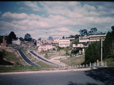
 Kew Historical Society Inc
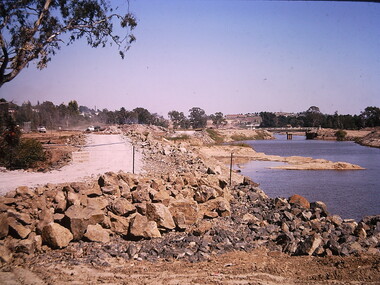
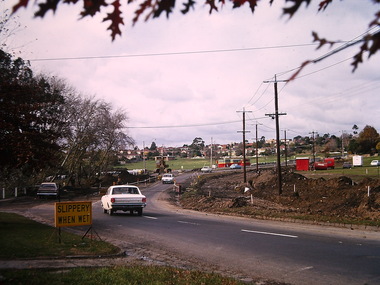
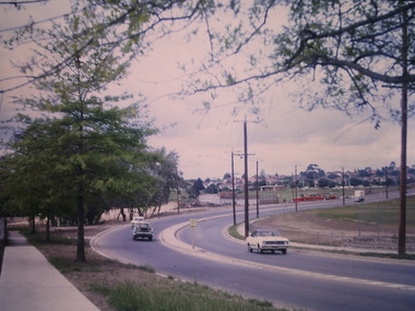
Photograph - Construction of the Eastern Freeway (F19), Ron Setford, March 1972
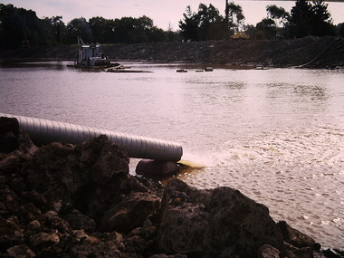
Ron Setford and his wife Grace Setford lived in Tanner Avenue, East Kew, from c.1946 to c.1995. A keen photographer, he recorded the changing face of Kew over a 20 year period. Apart from 30 photographs of built structures and places in Kew dating from 1960 and 1961, 145 of his 35mm colour slides chronicle the development of the F19 (later renamed Eastern) Freeway through the Yarra Valley in Kew over a five year period from c.1972 to c.1977. This important collection was donated to the Society by his granddaughter in 2025.This collection of 175 35mm slides is of local and statewide significance, owing to its subject matter, particularly the major development of road transport infrastructure during the 1970s with the construction of the Eastern Freeway. The photographer also took care to annotate and date most of his slides which enable the researcher to pinpoint temporal and spatial locations.Photograph of works involved in construction of the F19 (now Eastern) Freeway. The photo shows how construction sometimes took account of key environmental features; in this case the Kew Billabong."Eastern Freeway / "The Lagoon" to be saved at all costs"ron setford, eastern freeway, f19 freeway, kew billabong -
 Kew Historical Society Inc
Photograph - Construction of the Eastern Freeway (F19), Ron Setford, March 1972
Ron Setford and his wife Grace Setford lived in Tanner Avenue, East Kew, from c.1946 to c.1995. A keen photographer, he recorded the changing face of Kew over a 20 year period. Apart from 30 photographs of built structures and places in Kew dating from 1960 and 1961, 145 of his 35mm colour slides chronicle the development of the F19 (later renamed Eastern) Freeway through the Yarra Valley in Kew over a five year period from c.1972 to c.1977. This important collection was donated to the Society by his granddaughter in 2025.This collection of 175 35mm slides is of local and statewide significance, owing to its subject matter, particularly the major development of road transport infrastructure during the 1970s with the construction of the Eastern Freeway. The photographer also took care to annotate and date most of his slides which enable the researcher to pinpoint temporal and spatial locations.Photograph of works involved in construction of the F19 (now Eastern) Freeway. The photo shows how construction sometimes took account of key environmental features; in this case the Kew Billabong."Eastern Freeway / Sept 72"ron setford, eastern freeway, f19 freeway -
 Kew Historical Society Inc
Photograph - Construction of the Eastern Freeway (F19), Ron Setford, March 1972
Ron Setford and his wife Grace Setford lived in Tanner Avenue, East Kew, from c.1946 to c.1995. A keen photographer, he recorded the changing face of Kew over a 20 year period. Apart from 30 photographs of built structures and places in Kew dating from 1960 and 1961, 145 of his 35mm colour slides chronicle the development of the F19 (later renamed Eastern) Freeway through the Yarra Valley in Kew over a five year period from c.1972 to c.1977. This important collection was donated to the Society by his granddaughter in 2025.This collection of 175 35mm slides is of local and statewide significance, owing to its subject matter, particularly the major development of road transport infrastructure during the 1970s with the construction of the Eastern Freeway. The photographer also took care to annotate and date most of his slides which enable the researcher to pinpoint temporal and spatial locations.Kilby Rd, Willsmere Park on left"Eastern Freeway / Kilby Road / Nov 72"ron setford, eastern freeway, f19 freeway, willsmere park, kilby road -
 Kew Historical Society Inc
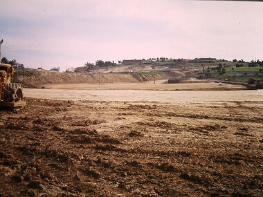
Photograph - Construction of the Eastern Freeway (F19), Ron Setford, March 1972
Ron Setford and his wife Grace Setford lived in Tanner Avenue, East Kew, from c.1946 to c.1995. A keen photographer, he recorded the changing face of Kew over a 20 year period. Apart from 30 photographs of built structures and places in Kew dating from 1960 and 1961, 145 of his 35mm colour slides chronicle the development of the F19 (later renamed Eastern) Freeway through the Yarra Valley in Kew over a five year period from c.1972 to c.1977. This important collection was donated to the Society by his granddaughter in 2025.This collection of 175 35mm slides is of local and statewide significance, owing to its subject matter, particularly the major development of road transport infrastructure during the 1970s with the construction of the Eastern Freeway. The photographer also took care to annotate and date most of his slides which enable the researcher to pinpoint temporal and spatial locations. Kilby Rd, Willsmere Park on left Kilby Rd, Willsmere Park on left" E Freeway Nov 1972"ron setford, eastern freeway, f19 freeway, willsmere park, kilby road -
 Kew Historical Society Inc
Photograph - Construction of the Eastern Freeway (F19), Ron Setford, March 1972
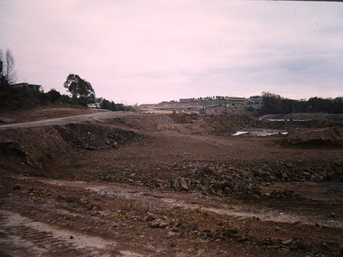
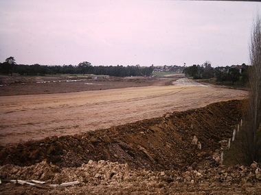
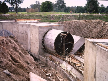
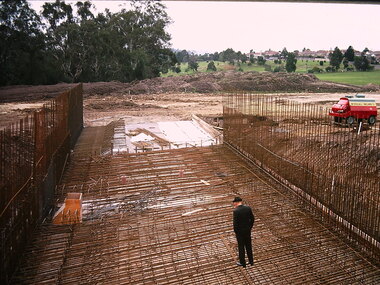
Ron Setford and his wife Grace Setford lived in Tanner Avenue, East Kew, from c.1946 to c.1995. A keen photographer, he recorded the changing face of Kew over a 20 year period. Apart from 30 photographs of built structures and places in Kew dating from 1960 and 1961, 145 of his 35mm colour slides chronicle the development of the F19 (later renamed Eastern) Freeway through the Yarra Valley in Kew over a five year period from c.1972 to c.1977. This important collection was donated to the Society by his granddaughter in 2025.This collection of 175 35mm slides is of local and statewide significance, owing to its subject matter, particularly the major development of road transport infrastructure during the 1970s with the construction of the Eastern Freeway. The photographer also took care to annotate and date most of his slides which enable the researcher to pinpoint temporal and spatial locations."Eastern Freeway 6/72 / Rock fill in old river bed"ron setford, eastern freeway, f19 freeway -
 Kew Historical Society Inc
Photograph - Construction of the Eastern Freeway (F19), Ron Setford, March 1972
Ron Setford and his wife Grace Setford lived in Tanner Avenue, East Kew, from c.1946 to c.1995. A keen photographer, he recorded the changing face of Kew over a 20 year period. Apart from 30 photographs of built structures and places in Kew dating from 1960 and 1961, 145 of his 35mm colour slides chronicle the development of the F19 (later renamed Eastern) Freeway through the Yarra Valley in Kew over a five year period from c.1972 to c.1977. This important collection was donated to the Society by his granddaughter in 2025.This collection of 175 35mm slides is of local and statewide significance, owing to its subject matter, particularly the major development of road transport infrastructure during the 1970s with the construction of the Eastern Freeway. The photographer also took care to annotate and date most of his slides which enable the researcher to pinpoint temporal and spatial locations." Eastern Freeway 6/72 / Embankment approx half height"ron setford, eastern freeway, f19 freeway -
 Kew Historical Society Inc
Photograph - Construction of the Eastern Freeway (F19), Ron Setford, March 1972
Ron Setford and his wife Grace Setford lived in Tanner Avenue, East Kew, from c.1946 to c.1995. A keen photographer, he recorded the changing face of Kew over a 20 year period. Apart from 30 photographs of built structures and places in Kew dating from 1960 and 1961, 145 of his 35mm colour slides chronicle the development of the F19 (later renamed Eastern) Freeway through the Yarra Valley in Kew over a five year period from c.1972 to c.1977. This important collection was donated to the Society by his granddaughter in 2025.This collection of 175 35mm slides is of local and statewide significance, owing to its subject matter, particularly the major development of road transport infrastructure during the 1970s with the construction of the Eastern Freeway. The photographer also took care to annotate and date most of his slides which enable the researcher to pinpoint temporal and spatial locations."Eastern Freeway 6/72 / Kew Main Drain extension under freeway"ron setford, eastern freeway, f19 freeway -
 Kew Historical Society Inc
Photograph - Construction of the Eastern Freeway (F19), Ron Setford, March 1972
Ron Setford and his wife Grace Setford lived in Tanner Avenue, East Kew, from c.1946 to c.1995. A keen photographer, he recorded the changing face of Kew over a 20 year period. Apart from 30 photographs of built structures and places in Kew dating from 1960 and 1961, 145 of his 35mm colour slides chronicle the development of the F19 (later renamed Eastern) Freeway through the Yarra Valley in Kew over a five year period from c.1972 to c.1977. This important collection was donated to the Society by his granddaughter in 2025.This collection of 175 35mm slides is of local and statewide significance, owing to its subject matter, particularly the major development of road transport infrastructure during the 1970s with the construction of the Eastern Freeway. The photographer also took care to annotate and date most of his slides which enable the researcher to pinpoint temporal and spatial locations."Eastern Freeway 6/72 / Willsmere Park flood underpass"ron setford, eastern freeway, f19 freeway -
 Kew Historical Society Inc
Photograph - Construction of the Eastern Freeway (F19), Ron Setford, March 1972
Ron Setford and his wife Grace Setford lived in Tanner Avenue, East Kew, from c.1946 to c.1995. A keen photographer, he recorded the changing face of Kew over a 20 year period. Apart from 30 photographs of built structures and places in Kew dating from 1960 and 1961, 145 of his 35mm colour slides chronicle the development of the F19 (later renamed Eastern) Freeway through the Yarra Valley in Kew over a five year period from c.1972 to c.1977. This important collection was donated to the Society by his granddaughter in 2025.This collection of 175 35mm slides is of local and statewide significance, owing to its subject matter, particularly the major development of road transport infrastructure during the 1970s with the construction of the Eastern Freeway. The photographer also took care to annotate and date most of his slides which enable the researcher to pinpoint temporal and spatial locations.Photograph of works involved in construction of the F19 (now Eastern) Freeway. The photo shows how construction sometimes took account of key environmental features; in this case the Kew Billabong."Eastern Freeway / pumping out of old river"ron setford, eastern freeway, f19 freeway -
 Kew Historical Society Inc
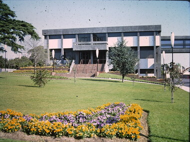
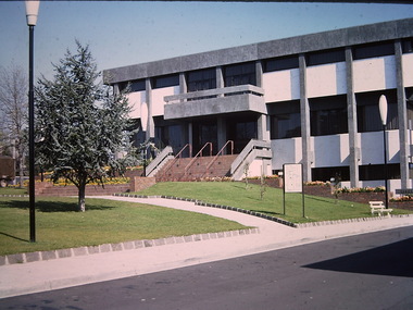
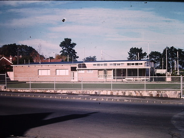
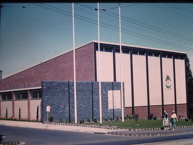
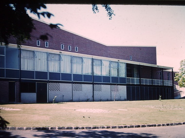
Photograph - Kew City Hall, Ron Setford, 1960
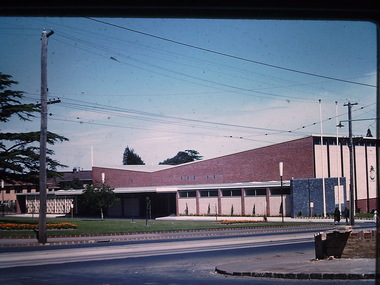
Ron Setford and his wife Grace Setford lived in Tanner Avenue, East Kew, from c.1946 to c.1995. A keen photographer, he recorded the changing face of Kew over a 20 year period. Apart from 30 photographs of built structures and places in Kew dating from 1960 and 1961, 145 of his 35mm colour slides chronicle the development of the Eastern Freeway through the Yarra Valley over a five year period from c.1972 to c.1977. This important collection was donated to the Society by his granddaughter in 2025.This collection of 175 35mm slides is of local and statewide significance, owing to its subject matter, particularly the major development of road transport infrastructure during the 1970s with the construction of the Eastern Freeway. The photographer also took care to annotate and date most of his slides which enable the researcher to pinpoint temporal and spatial locations.The Kew City Hall in Cotham Road, designed by Harold Bartlett, was intended as the initial phase in a scheme to develop an entire civic precinct. This was representative of a widely-held belief, of the immediate post-war era, that a district's civic centre should be precisely that – not just a single grand building for official use, but a dedicated precinct providing a range of community facilities as well as an administrative function. The Kew masterplan was later abandoned. The City Hall was designed to cater for public or official functions. Its interior had a small stage at one end for intimate theatrical productions, a larger stage at the other (with sunken orchestra pit) for musical performances, plus the most up-to-date equipment for live TV transmission."Kew Town Hall"ron setford, photographs -- kew (vic.) -- 1960s, kew town hall -
 Kew Historical Society Inc
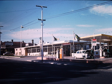
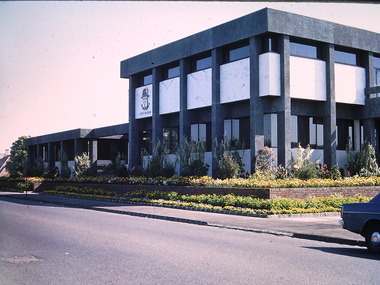
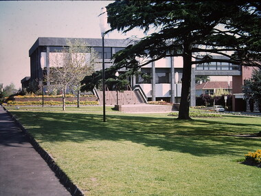
Photograph - Country Roads Board and Denmark Street Baby Health Centre, Ron Setford, 1961
Ron Setford and his wife Grace Setford lived in Tanner Avenue, East Kew, from c.1946 to c.1995. A keen photographer, he recorded the changing face of Kew over a 20 year period. Apart from 30 photographs of built structures and places in Kew dating from 1960 and 1961, 145 of his 35mm colour slides chronicle the development of the Eastern Freeway through the Yarra Valley over a five year period from c.1972 to c.1977. This important collection was donated to the Society by his granddaughter in 2025.This collection of 175 35mm slides is of local and statewide significance, owing to its subject matter, particularly the major development of road transport infrastructure during the 1970s with the construction of the Eastern Freeway. The photographer also took care to annotate and date most of his slides which enable the researcher to pinpoint temporal and spatial locations.A photograph providing a visual contrast of the pre and post-World War II architectural styles of the Denmark Street Baby Health Centre and two of the Country Roads Board office buildings. Each was built on part of the land fronting the Kew branch line. In May 1939, the Railway Commissioners agreed to lease a site at the Kew Railway Station for a Baby Health Centre. The single-storey cream brick building was designed by Roland Chipperfield. The Country Roads Board (1913–83), later renamed VicRoads, transferred its headquarters from the Royal Exhibition Building to Kew in 1961, following the completion of two modernist eight-storey office towers in 1960. The VicRoads buildings were closed in 2024, and there is ongoing debate about what replaces them.Nilron setford, photographs -- kew (vic.) -- 1960s, country roads board, vicroads, denmark street -- kew (vic.), denmark street baby health centre -
 Kew Historical Society Inc
Photograph - Kew City Hall, Ron Setford, 1960
Ron Setford and his wife Grace Setford lived in Tanner Avenue, East Kew, from c.1946 to c.1995. A keen photographer, he recorded the changing face of Kew over a 20 year period. Apart from 30 photographs of built structures and places in Kew dating from 1960 and 1961, 145 of his 35mm colour slides chronicle the development of the Eastern Freeway through the Yarra Valley over a five year period from c.1972 to c.1977. This important collection was donated to the Society by his granddaughter in 2025.This collection of 175 35mm slides is of local and statewide significance, owing to its subject matter, particularly the major development of road transport infrastructure during the 1970s with the construction of the Eastern Freeway. The photographer also took care to annotate and date most of his slides which enable the researcher to pinpoint temporal and spatial locations.The Kew City Hall in Cotham Road, designed by Harold Bartlett, was intended as the initial phase in a scheme to develop an entire civic precinct. This was representative of a widely-held belief, of the immediate post-war era, that a district's civic centre should be precisely that – not just a single grand building for official use, but a dedicated precinct providing a range of community facilities as well as an administrative function. The Kew masterplan was later abandoned. The City Hall was designed to cater for public or official functions. Its interior had a small stage at one end for intimate theatrical productions, a larger stage at the other (with sunken orchestra pit) for musical performances, plus the most up-to-date equipment for live TV transmission.Nilron setford, photographs -- kew (vic.) -- 1960s, kew town hall -
 Whitehorse Historical Society Inc.
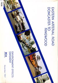
Book - Government Environment Effects Statement, Road Construction Authority (now part of VicRoads), Eastern Arterial Road - Doncaster to Ringwood, November 1987
The book covers the Environment Effects Statement for the Eastern Arterial Road Extension from Doncaster to Ringwood and the Ringwood Bypass. Aspects covered are development works, traffic affects, public transport, landscape and visual affects, noise, pedestrian/ bicycle access, lighting, air quality and construction affects. Includes maps, cross sections, photos.The book covers the Environment Effects Statement for the Eastern Arterial Road Extension from Doncaster to Ringwood and the Ringwood Bypass. Aspects covered are development works, traffic affects, public transport, landscape and visual affects, noise, pedestrian/ bicycle access, lighting, air quality and construction affects. Includes maps, cross sections, photos.non-fictionThe book covers the Environment Effects Statement for the Eastern Arterial Road Extension from Doncaster to Ringwood and the Ringwood Bypass. Aspects covered are development works, traffic affects, public transport, landscape and visual affects, noise, pedestrian/ bicycle access, lighting, air quality and construction affects. Includes maps, cross sections, photos.eastern freeway extension, eastern arterial road, mullum mullum creek, road construction, environmental impact -
 Kew Historical Society Inc
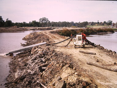
Photograph - Construction of the Eastern Freeway (F19), Ron Setford, March 1972
Ron Setford and his wife Grace Setford lived in Tanner Avenue, East Kew, from c.1946 to c.1995. A keen photographer, he recorded the changing face of Kew over a 20 year period. Apart from 30 photographs of built structures and places in Kew dating from 1960 and 1961, 145 of his 35mm colour slides chronicle the development of the F19 (later renamed Eastern) Freeway through the Yarra Valley in Kew over a five year period from c.1972 to c.1977. This important collection was donated to the Society by his granddaughter in 2025.This collection of 175 35mm slides is of local and statewide significance, owing to its subject matter, particularly the major development of road transport infrastructure during the 1970s with the construction of the Eastern Freeway. The photographer also took care to annotate and date most of his slides which enable the researcher to pinpoint temporal and spatial locations.Photograph of works involved in construction of the F19 (now Eastern) Freeway involving rerouting the River Yarra in Kew."Eastern Freeway / pumping out old river bed"ron setford, eastern freeway, f19 freeway