Showing 186 items matching "trees in victoria park"
-
 Glenelg Shire Council Cultural Collection
Postcard - Postcard - Casterton, Victoria, 1960s
Sourced from Casterton Town Hall (former Shire of Glenelg)Postcard, black and white, Island Park, Casterton, showing football oval and pavilion, gum trees in backgroundFront: 'ISLAND PARK, CASTERTON, VIC', '4015' in bottom margin Back: Maker's stamptourism, travel, casterton -
Glenelg Shire Council Cultural Collection
Postcard - Postcard - Hospital Portland , Victoria, n.d
Black and white photo postcard. View of old Portland hospital, taken from street (Bentinck or Fern). Buildings obscured by large trees, and high stone fence. Nurse standing either side of metal gate, with a 'PORTLAND HOSPITAL' sign on it. Woman in a two-seater roadster parked near gate. A man and 2 nurses can be seen in the groundsFront: 'THE PUBLIC HOSPITAL, PORTLAND VIC. TOYE, PHOTO' - white script on black bottom border Back: Purple stamp: 'TOYE BROS. Photographers, Hamilton & Portland' -
 Eltham District Historical Society Inc
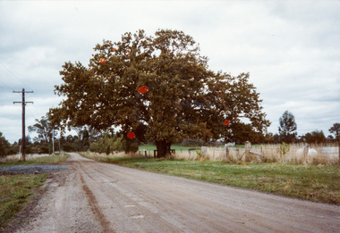
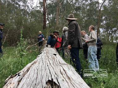
Photograph, Donaldson Oak, Donaldson Road, Kangaroo Ground, 1986, 1986
Used for the Society's Banner project. [note written by Joy Ness, "View Hill", Kangaroo Ground, 11 June 1986:] In 1878 while on a trip to Scotland and England, John Donaldson visited Windsor Castle Park, where he collected some acorns which he brought back to Australia, to his property, "Kangaroo Hall" at Kangaroo Ground. He and his son John Anstruther Davidson Donaldson, who was then 10 years old, planted one near the present Donaldson's Lane, in 1878. This is now a very fine tree, 108 years old. This information comes from Miss Victoria Donaldson, daughter of John Anstruther Davidson Donaldson. Miss Donaldson suggests that Wippell's Oak at Kangaroo Ground may also have been grown from one of the same Windsor Park acorns.Colour photographactivities, banner project, donaldsons oak, john anstruther davidson donaldson, kangaroo ground, significant trees, william donaldson -
 Eltham District Historical Society Inc
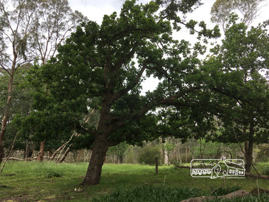
Photograph, Peter Pidgeon, Killeavey, Laughing Waters Road, Eltham 5 Nov 2016, 5 Nov 2016
These two Portuguese Oaks on the property are extremely rare and even on the Iberuan peninsular these trees are now rare and endangered. Heriitage Excursion - Kileavey Walk and TalkBorn Digitalactivities, eltham district historical society, heritage excursion, kileavey, parks victoria, laughing waters road, eltham -
 Eltham District Historical Society Inc
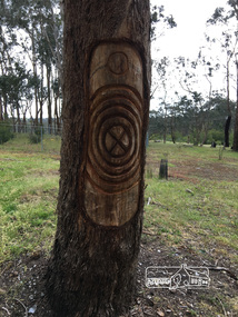
Photograph, Peter Pidgeon, Killeavey, Laughing Waters Road, Eltham 5 Nov 2016, 5 Nov 2016
This tree carving represents the ceremonial circle at the meeting place formed on the site of the original homestead. The replicating circles reflecting the life stories. Heriitage Excursion - Kileavey Walk and TalkBorn Digitalactivities, eltham district historical society, heritage excursion, kileavey, parks victoria, laughing waters road, eltham, wurundjeri -
 Eltham District Historical Society Inc
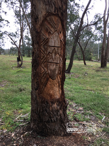
Photograph, Peter Pidgeon, Killeavey, Laughing Waters Road, Eltham 5 Nov 2016, 5 Nov 2016
Carvings by more recent Wurundjeri people on three trees. This tree represents the tree of knowledge. Heriitage Excursion - Kileavey Walk and TalkBorn Digitalactivities, eltham district historical society, heritage excursion, kileavey, parks victoria, laughing waters road, eltham, wurundjeri -
 Eltham District Historical Society Inc
Photograph, Peter Pidgeon, Killeavey, Laughing Waters Road, Eltham 5 Nov 2016, 5 Nov 2016
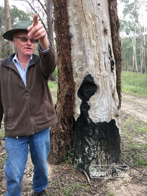
Cam pointing out the ravages on various trees from the 1939, 1967 and 1969 fires. This tree bares evidence from the 1939 bushfire which raged through the area. Heriitage Excursion - Kileavey Walk and TalkBorn Digitalactivities, eltham district historical society, heritage excursion, kileavey, parks victoria, laughing waters road, eltham, wurundjeri, black friday 1939 -
 Eltham District Historical Society Inc
Photograph, Peter Pidgeon, Killeavey, Laughing Waters Road, Eltham 5 Nov 2016, 5 Nov 2016
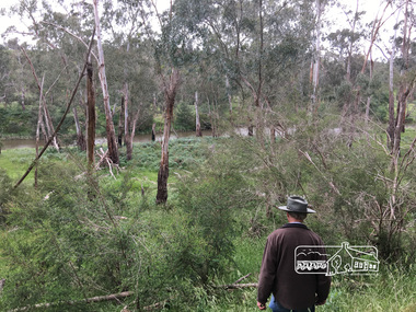
The beautiful Yarra river lies before us; the scar or 'toe hold' tree lies in front of Cam to the right Heriitage Excursion - Kileavey Walk and TalkBorn Digitalactivities, eltham district historical society, heritage excursion, kileavey, parks victoria, laughing waters road, eltham, wurundjeri -
 Eltham District Historical Society Inc
Photograph, Peter Pidgeon, Killeavey, Laughing Waters Road, Eltham 5 Nov 2016, 5 Nov 2016
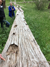
This scar or 'toe hold' tree fell over 50 yrs ago. It had died 50yrs before it fell and is estimated to be around 400 years old. It has a diameter of 1.3 m and is the only 'toe hold' tree in Nillumbik. Heriitage Excursion - Kileavey Walk and TalkBorn Digitalactivities, eltham district historical society, heritage excursion, kileavey, parks victoria, laughing waters road, eltham, wurundjeri -
 Eltham District Historical Society Inc
Photograph, Peter Pidgeon, Killeavey, Laughing Waters Road, Eltham 5 Nov 2016, 5 Nov 2016
'Toe hold' tree has 16 equally spaced cuttings Heriitage Excursion - Kileavey Walk and TalkBorn Digitalactivities, eltham district historical society, heritage excursion, kileavey, parks victoria, laughing waters road, eltham, wurundjeri -
 Eltham District Historical Society Inc
Photograph, Peter Pidgeon, Killeavey, Laughing Waters Road, Eltham 5 Nov 2016, 5 Nov 2016
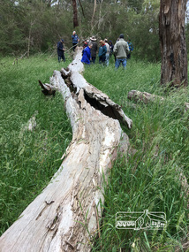
Cam from Parks Victoria demonstrating how the Wurundjeri would have climbed the 'toe hold' tree Heriitage Excursion - Kileavey Walk and TalkBorn Digitalactivities, eltham district historical society, heritage excursion, kileavey, parks victoria, laughing waters road, eltham, wurundjeri -
 Eltham District Historical Society Inc
Photograph, Donaldson's Oak, Donaldsons Road, Kangaroo Ground, c.1967
Quercus Robur (English Oak) - Was planted by John Donaldson from seed collected from Windsor Great Park in 1878. Used for the Society's Banner project Joy Ness "View Hill" Kangaroo Ground June 11th 1986 In 1878 while on a trip to Scotland and England, John Donaldson visited Windsor Castle Park, where he collected some acorns which he brought back to Australia, to his property, "Kangaroo Hall" at Kangaroo Ground. He and his son John Anstruther Davidson Donaldson, who was then 10 years old, planted one near the present Donaldsons Lane, in 1878. This is now a very fine tree, 108 years old. This information comes from Miss Victoria Donaldson, daughter of John Anstruther Davidson Donaldson. Miss Donaldson suggests that "Wippell's Oak" at Kangaroo Ground may also have been grown from one of the same Windsor Park acorns.Colour Polaroid photographtrees, donaldsons oak, donaldson, donaldson road, kangaroo ground -
 Victoria Police Museum
Photograph (police car)
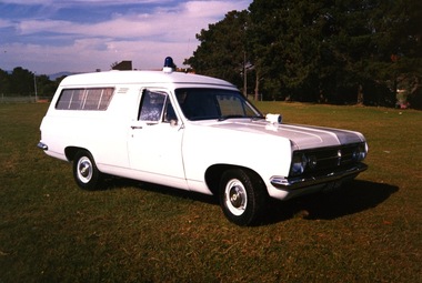
A 1967 Holden Divisional Van, registration number JVB-464, with a siren on the bonnet and a blue light on the roof. The van windows have visible reinforcement. The photograph has been taken in a park with large trees in the background. There is no visible insignia on the car. Circa 1991police vehicles; motor transport branch; motor transport section; wireless patrol: holden van -
 Victoria Police Museum
Photograph (police car)
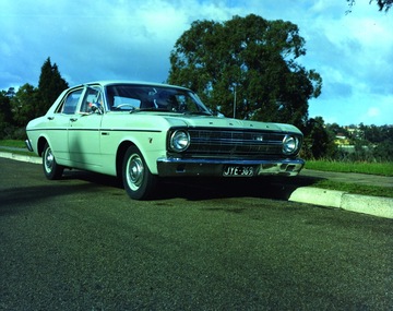
Ford Falcon Q car, registration number JYE-369, with unidentified driver and passenger. The car is parked on a sealed road with a large tree and parkland in the background. Circa 1967police vehicles; motor transport branch; motor transport section; wireless patrol; ford falcon q car; camera car -
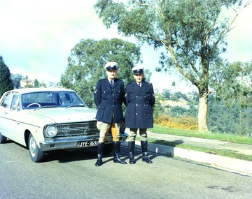 Victoria Police Museum
Photograph (police car)
Two police officers standing in front of a Ford Falcon Q car, registration number JYE-369. The man on the left is wearing jodphurs, riding boots, coat and hat. The man on the right is wearing boots. leggings, overcoat and hat. The car is parked on a sealed road with a large tree and parkland in the background. Circa 1967police vehicles; motor transport branch; motor transport section; wireless patrol; ford falcon q car; camera car -
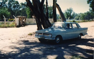 Victoria Police Museum
Photograph (police car)
Mildura Mobile Traffic Section patrol car at Lock 3 near Mildura.Ford Zephyr, registration number HRH-911, parked under a tree with a driver and passenger inside the car. There is a man in the background standing bent over near a bicycle. Circa 1961police vehicles; wireless patrol; motor transport branch; motor transport section; ford zephyr car -
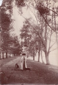 Learmonth and District Historical Society Inc.
Photograph, Lily Jones with dogs by Lake Learmonth, Circa 1890's - 1910
This photo has been taken at Richmond Park, Lake Learmonth, Victoria. The woman in the photo is likely to be Lily Jones with her two dogs. The lake is to the right hand side of the photo.It is one of the many photos of the early period of Lake Learmonth and one of the inhabitants. Also the beautiful outfit that Lily Jones is wearing shows the style of day wear from the late 1800's.Sepia photo of Lily Jones with her two dogs, taken at Richmond Park, Lake Learmonth with gum trees in the background.On the back of this photo is written, Richmond Park, Lake Learmonth. Lily Jones, photo, Learmonth.lake learmonth. richmond park. lily jones. dogs. gum trees. -
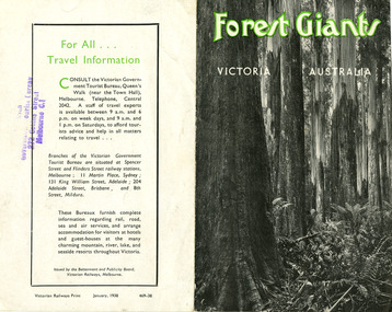 Marysville & District Historical Society
Ephemera (Item) - Information brochure, Victorian Government Tourist Bureau, Forest Giants Victoria Australia, 01-1938
An information brochure on where to see tall trees, Forest Giants, in Victoria, including Marysville, that was published in January, 1938.An information brochure on where to see tall trees, Forest Giants, in Victoria, including Marysville, that was published in January, 1938.Victorian Railways Print January, 1938 469-38 Stamp of Victorian/ Government Tourist Bureau/ 272 Collins Street/ Melbourne C.1victoria, australia, victorian government tourist bureau, betterment and publicity board, victorian railways, white mountain ash, red mountain ash, messmate, blue gum, mountain ash, cumberland valley, marysville, mount monda, healesville, acheron way, alpine highway, omeo, baw baws, strzelecki ranges, otway ranges, warburton, yarra junction, noojee, bulga and tarra valley park, yarram, turton's pass, otway forest, beech forest, apollo bay, information brochure, brochure -
 Marysville & District Historical Society
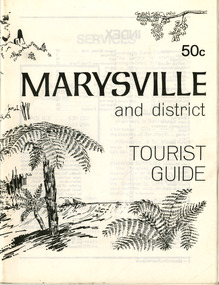
Booklet (Item) - Tourist guide, Ian and Danese Walshe et al, MARYSVILLE and district TOURIST GUIDE, 1982
A tourist guide outlining services, accommodation, activities and places of interest to visit in and around Marysville and the local district.A tourist guide outlining services, accommodation, activities and places of interest to visit in and around Marysville and the local district.marysville, victoria, australia, tourist guide, marysville hotel, castles' store, hawthorne's corner shop, tudor lodge, black spur motel and caravan park, buxton general store, golden fleece roadhouse, marysville garage, burrengeen park, lake mountain, steavenson falls, nanda binya lodge, alpenglow nursery, black spur inn hotel, silver stream trout farm, mccfarlane's grocery, barton's drapery, marysville newsagency, eildon explorer, beauty spot nursery, crossways, pumpernickel, mckenzie's tourist services, blue hills riding school, mountain view horse hire, pitt's garage, maryton park, j l gould sawmill, eildon deer park, eildon weir, maroondah dam, snob's creek, healesville sanctuary, graceburn park, cathedral range, beauty spot walk, tree fern gully walk, michaeldene track, keppel track, woods lookout track, cumberland scenic reserve, cambarville, the big tree, cora-lyn falls, barton's lookout, cumberland falls, sovereign view, wirreanda festival, scenic motel, tower motel, marylands guest house, kooringa guest house, marylyn guest house, mountain lodge, el kanah, marysville hotel motel, buxton hotel motel, black spur inn, buxton caravan park, marysville caravan park, the cumberland, marysville recreation and fun park -
 Marysville & District Historical Society
Booklet (Item) - Leisure guide, Michael Chesire & Associates Pty. Ltd, MARYSVILLE & DISTRICT LEISURE GUIDE-AUTUMN/WINTER, 1986, 1986
A free leisure guide to Marysville and the surrounding district published for Autumn and Winter, 1986. This was produced by Michael Cheshire as a free publication to promote tourism in Marysville and the surrounding district. It includes maps of the Big River Valley, Cumberland Valley, Lady Talbot Forest Drive, the Marysville area, and the township of Marysville. It was released in the autumn of 1986 and was sponsored by the Marysville Tourist & Progress Association. The Association was formed in November 1907 to promote tourism within the area. This included the physical creation of signage, parklands, roads, and walks to various attractions. A free leisure guide to Marysville and the surrounding district published for Autumn and Winter, 1986.marysville, victoria, australia, leisure guide, michael cheshire & associates pty ltd, marysville golf club, blackwood lodges, sir colin mackenzie fauna park, lake eildon, fraser national park, yarra valley wineries, marysville coach tours, kooringa, marylands guest house, lady talbot forest drive, wishing well, taggerty river recreation area, athols abbey, phantom falls, keppel falls, the beeches walking track, marylyn guest house, kufstein inn motel, the cumberland, marysville tourist & progress association, marysville newsagency & general store, crossways restaurant & motel, beauty spot walk, tree fern gully walk, michaeldene track, keppel track, woods lookout track, marysville hotel motel, lake mountain ski hire, marysville recreation and fun park, mytanta horseback safaris, upper big river valley, the big culvert, marysville mountain view horse hire, maryton park, amber view holiday lodges, cathedral restaurant, the top shop, tower motel, menzes garage, beauty spot nursery, marysville ski hire, lake mountain ski school, faraway forest, scenic motel, buxton trout farm, marysville hardware, timbertop steakhouse, marysville trout farm, healesville sanctuary, buxton hotel motel, nanda binya lodge, buxton antique and furniture mart, the black spur inn hotel, alexandra, lake mountain, geoffrey pope & associates -
 Marysville & District Historical Society
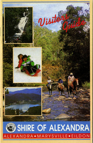
Ephemera (Item) - Visitors Guide, Shire of Alexandra, Visitors Guide ALEXANDRA-MARYSVILLE-EILDON, Unknown
A tourist guide for Alexandra, Marysville and Eildon produced by the Shire of Alexandra.A tourist guide for Alexandra, Marysville and Eildon produced by the Shire of Alexandra.alexandra, marysville, eildon, victoria, australia, shire of alexandra, visitor guide, danish coffee garden, maryton park, marysville hotel motel, beauty spot gardens, geoffrey pope & associates, australian bush pioneer's farm, marysville recreation and fun park, blackwood lodges, marysville newsagency & general store, the cumberland, marysville gallery, marysville gallery restaurant, mount cathedral lodge, cross country ski hire, menzes garage, marysville craft & gifts, esa camping & conference centre, el kanah, black spur motel and caravan park, marysville caravan park, buxton trout farm, the camel farm buxton, marysville golf and bowls club, taggerty general store, cathedral restaurant, marylyn guest house, beauty spot walk, tree fern gully walk, michaeldene track, keppel track, woods lookout track -
 Marysville & District Historical Society
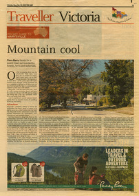
Newspaper (Item) - Newspaper article, The Age, POCKET GUIDE TO MARYSVILLE, 22-11-2008
A newspaper article on Marysville, its local attractions, places to shop and dine, where to stay and ways of traveling to Marysville. This article was published in The Age on Saturday, November 22, 2008.A newspaper article on Marysville, its local attractions, places to shop and dine, where to stay and ways of traveling to Marysville.marysville, victoria, australia, the age, black spur, marysville visitor information centre, steavenson falls, lady talbot drive, taggerty river, keppel falls, phantom falls, beeches rainforest walk, cambarville, yarra ranges national park, the big tree, cumberland walk, lake mountain, steavenson river, acheron river, buxton bait and tackle, marysville trout and salmon ponds, buxton trout and salmon farm, bruno's art and sculpture garden, villa day spa, cathedral view natural therapies, marysville massage, murchison street, village walk, uncle fred & aunty val's old style lolly shop, country touch gallery, manical mechanicals, hidden talent craft gallery, carmyle farm boutique, marysville community market, marysville patisserie, marysville country bakery, fraga's cafe restaurant, terracotta room, marylands country house, the cumberland, mantirri blueberry farm, narbethong, marysville farmers market, the black spur inn, allawah country cottages, barree mud brick cottages -
 Marysville & District Historical Society
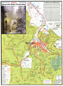
Map (Item) - Pocket map, Rooftop Mapping Services, Rooftop's Marysville Walks Pocket Map, 01-2009
A pocket map of ten walking tracks in an around Marysville. This map was published by Rooftop Mapping Services in January 2009.A pocket map of ten walking tracks in an around Marysville.marysville, victoria, australia, rooftop mapping services, steavenson falls, steavenson falls car park walk, beauty spot walk, marysville to el kanah guest house walk, gilberts gully walk, michaeldene track, man 'o' war walk, tree fern gully walk, marysville to woods lookout to mount gordon walk, keppels lookout walk -
 Marysville & District Historical Society
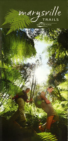
Map (Item) - Walking map, Department of Sustainability and Environment, marysville TRAILS, 07-2011
A map showing all the walking trails in and around Marysville and the district. This map was produced by the Department of Sustainability and Environment in July 2011.A map showing all the walking trails in and around Marysville and the district.ISBN 978-1-74287-122-6 (print)marysville, victoria, australia, marysville trails, department of sustainability and environment, parks victoria, steavenson falls trail, beauty spot trail, gilberts gully trail, tree fern gully trail, michaeldene trail, wilks creek trail, keppel lookout trail, lady talbot drive, taggerty cascades, the beeches, keppel falls, phantom falls, cathedral range state park, cambarville, lake mountain trails, cumberland falls, mystic mountains tourism -
 Marysville & District Historical Society
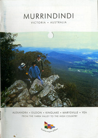
Booklet (Item) - Information booklet, Alexandra Newspapers, MURRINDINDI VICTORIA-AUSTRALIA, 02-2004
An information booklet on the Murrindindi region in Victoria. This information booklet was produced by Alexandra Newspapers in partnership with the Murrindindi Regional Tourism Association in February 2004.An information booklet on the Murrindindi region in Victoria.Produced and published by Alexandra Newspapers/ Pty Ltd in partnership with the Murrindindi Regional/ Tourism Association. murrindindi, victoria, australia, alexandra, eildon, kinglake, marysville, yea, yarra valley, high country, visit victoria, alexandra newspapers, murrindindi tourism association, rubicon valley horse riding, cathedral range state park, murrindindi scenic reserve, yarra ranges national park, cumberland memorial scenic reserve, the big culvert, cambarville, the big tree, steavenson falls, cora lynn falls, cumberland falls, lady talbot drive, phantom falls, keppel falls, the beeches, the cascades, wilhelmina falls, murrindindi cascades, lake mountain, cathedral lane vineyard, south cathedral farm, marysville holiday cottages, crystal journey, country touch, marysville ski centre, mountain lodge marysville, eco adventure tours, the mountain gallery, marysville country real estate, camellia log cabin, crossways historic country inn, marylands country house, ashlar cottage b&b, kerami guesthouse, melina cottages, willowbank at taggerty, mary lyn holiday resort, kooringa resort & conference centre, marysville caravan & holiday park, lyell guest cottages, eagle mountain retreat, keppels hotel motel, anastasia fairytale cottage, mystic mountain holiday cottages, esa camping & conference centre, buxton trout & salmon farm, woodlands rainforest bungalows, the old woolshed cafe, yarrolyn holiday park -
Marysville & District Historical Society
Ephemera (Item) - Information brochure, Artworkz Tourism, MARYSVILLE TOWNSHIP, 11-2020
An information brochure on the township of Marysville in Victoria. This brochure was produced by Artworkz Tourism in November 2020.An information brochure on the township of Marysville in Victoria.Disclaimer: The authors have taken care to ensure this/ publication is correct, though please be aware that/ errors and omissions do occur.marysville, victoria, australia, information brochure, artworkz tourism, 2009 black saturday bushfires, bruno's sculpture garden, steavenson falls, gallipoli lake, keppel falls, lady talbot drive, cora lynn falls, cambarville walk, phantom falls, taggerty river visitor area, meeting of the waters, the beeches, cambarville day visitor area, the big tree, keppel hut, keppel lookout, mount gordon, marysville golf course, jock's lookout, gallipoli park, yellow dog day visitor area -
Marysville & District Historical Society
Ephemera (Item) - Information brochure, Artworkz Tourism, MARYSVILLE THINGS TO DO AROUND MARYSVILLE, 27-01-2018
An information brochure on things to do around Marysville in Victoria.An information brochure on things to do around Marysville in Victoria.Disclaimer: The authors have taken care to ensure this/ publication is correct, though please be aware that/ errors and omissions do occur.marysville, victoria, australia, information brochure, gallipoli park lake, gallipoli lake, steavenson falls, steavenson river, bruno's art and sculpture garden, fernshaw park, buxton recreation reserve, taggerty river areas, anderson mill camping area, cooks mill camping area, neds gully camping area, keppel creek day area, beauty spot nature walk, gilbert gully nature walk, michaeldene track, cathedral range, the beeches walk, tree fern gully walk, crystal journey, marysville market, lake mountain ski resort, marysville golf club, marysville public outdoor swimming pool, buxton trout & salmon farm, keppel's lookout, jock's lookout, mount gordon, armstrong lookout, keppel falls, phantom falls, cora lynn falls, meeting of the waters, st ronan's well, preiffer falls, camberville historical township, keppels hut, the big culvert, the big tree, marysville historical society -
Marysville & District Historical Society
Ephemera (Item) - Information brochure, Artworkz Tourism, MARYSVILLE-MARYSVILLE ATTRACTIONS, 23-11-2014
An information brochure on various attractions to be visited in an around Marysville. This brochure was produced by Artworkz Tourism in November 2014.An information brochure on various attractions to be visited in an around Marysville.Disclaimer: The authors have taken care to ensure this/ publication is correct, though please be aware that/ errors and omissions do occur.marysville, victoria, australia, information brochure, bruno's sculpture garden, steavenson falls, gallipoli lake, keppel falls, cora lynn falls, phantom falls, taggerty river visitor area, the beeches, meeting of the waters, cambarville day visitor area, the big tree, the big culvert, keppels hut, keppel lookout, mount gordon, marysville golf course, trestle bridge, marysville caravan park, marysville swimming pool, jock's lookout, yellow dog day visitor area, artworkz tourism -
Marysville & District Historical Society
Book (Item) - Ebook, Artworkz Tourism, Marysville Gallery, 05-2012
An ebook on various attractions to be visited in and around Marysville. This ebook was published by Artworkz Tourism in May 2012.An ebook on various attractions to be visited in and around Marysville.cambarville, cambarville waterfalls, cathedral state park, cora lynn falls, historic trestle bridge, jock's lookout, lady talbot drive, keppel falls, keppel hut, keppel lookout, gallipoli park, phantom falls, steavenson falls, taggerty river, taggerty cascades, the beeches rainforest walk, the big culvert, the big tree, meeting of the waters marysville, meeting of the waters buxton, marysville, victoria, australia, ebook -
Marysville & District Historical Society
Flyer (item) - Information Flyer, Parks Victoria, Yarra Ranges National Park-Lady Talbot Drive, Cambarville and Lake Mountain-Visitor Guide, 01-2018
A flyer that was produced as a guide to Lady Talbot Drive, Cambarville and Lake Mountain.A flyer that was produced as a guide to Lady Talbot Drive, Cambarville and Lake Mountain. Lady Talbot Drive a 24 kilometer scenic rainforest car journey which passes a number of walks and waterfalls in the Yarra Ranges National Park. Lady Talbot Drive is named after Lady Sarah Elizabeth, the wife of Sir Reginald Talbot, who was the Governor of Victoria from 25th April, 1904 to 6th July 1908. Cambarville is notable for its giant mountain ash (Eucalyptus regnans) trees within the Cumberland Memorial Scenic Reserve, and relics from former sawmills and gold mining. The Big Culvert is located nearby on the Marysville-Woods Point Road, which was historically part of the Yarra Track. Cambarville was established as a timber mill town in the 1940s. Timber mill owners A Cameron and FJ Barton named Cambarville. They established the mill to salvage timber from trees destroyed in the 1939 bushfires. Cambarville was impacted by the 2009 Black Saturday bushfires and any remaining structures were destroyed. Lake Mountain is the closest alpine cross-country ski resort to Melbourne.lady talbot drive, lady talbot forest drive, cambarville, lake mountain, sir reginald talbot, lady sarah elizabeth talbot