Showing 65 items
matching unmade street
-
 Eltham District Historical Society Inc
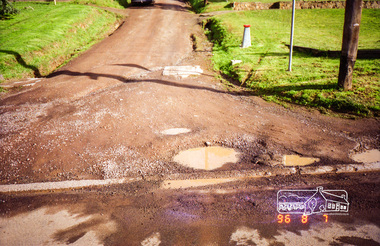
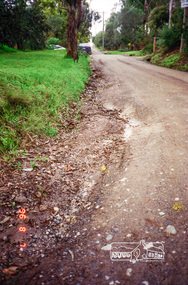
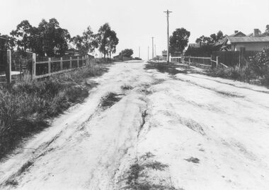
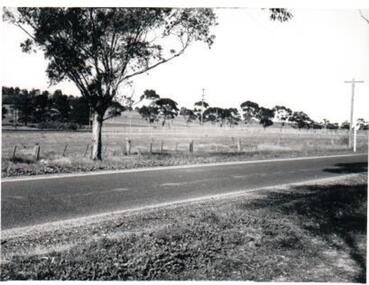
Photograph, Road surface conditions around Eltham: Looking west along John Street at the intersection with Bible Street, 7 Aug 1996, 1996
... Shows sections of Franklin, John and Napoleon streets were... melbourne Shows sections of Franklin, John and Napoleon streets were ...Shows sections of Franklin, John and Napoleon streets were still unmade as of late 1996 and the condition of those roads with potholes at the intersections with Bible Street.Reflects on the changing nature of the local street-scape and housesRoll of 35mm colour negative film, 7 stripsKodak Gold 100-5eltham, napoleon street, bible street, franklin street, john street -
 Eltham District Historical Society Inc
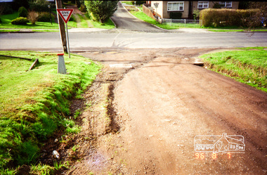
Photograph, Road surface conditions around Eltham: Looking east along John Street at the intersection with Bible Street, 7 Aug 1996, 1996
... Shows sections of Franklin, John and Napoleon streets were... melbourne Shows sections of Franklin, John and Napoleon streets were ...Shows sections of Franklin, John and Napoleon streets were still unmade as of late 1996 and the condition of those roads with potholes at the intersections with Bible Street.Reflects on the changing nature of the local street-scape and housesRoll of 35mm colour negative film, 7 stripsKodak Gold 100-5eltham, napoleon street, bible street, franklin street, john street -
 Eltham District Historical Society Inc
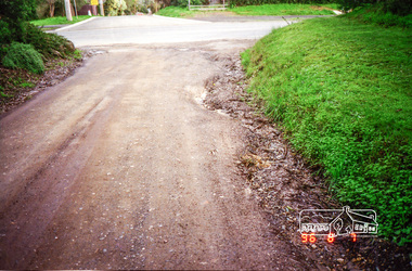
Photograph, Road surface conditions around Eltham: Napoleon Street looking east from intersection with Bible Street, 7 Aug 1996, 1996
... Shows sections of Franklin, John and Napoleon streets were... melbourne Shows sections of Franklin, John and Napoleon streets were ...Shows sections of Franklin, John and Napoleon streets were still unmade as of late 1996 and the condition of those roads with potholes at the intersections with Bible Street.Reflects on the changing nature of the local street-scape and housesRoll of 35mm colour negative film, 7 stripsKodak Gold 100-5eltham, napoleon street, bible street, franklin street, john street -
 Eltham District Historical Society Inc
Photograph, Road surface conditions around Eltham: Napoleon Street looking west across Bible Street, 7 Aug 1996, 1996
... Shows sections of Franklin, John and Napoleon streets were... melbourne Shows sections of Franklin, John and Napoleon streets were ...Shows sections of Franklin, John and Napoleon streets were still unmade as of late 1996 and the condition of those roads with potholes at the intersections with Bible Street.Reflects on the changing nature of the local street-scape and housesRoll of 35mm colour negative film, 7 stripsKodak Gold 100-5eltham, napoleon street, bible street, franklin street, john street -
 Eltham District Historical Society Inc
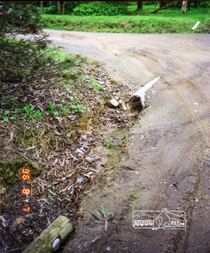
Photograph, Road surface conditions around Eltham: Napoleon Street at Bible Street, Eltham, looking south-east, 7 Aug 1996, 1996
... Shows sections of Franklin, John and Napoleon streets were... melbourne Shows sections of Franklin, John and Napoleon streets were ...Shows sections of Franklin, John and Napoleon streets were still unmade as of late 1996 and the condition of those roads with potholes at the intersections with Bible Street.Reflects on the changing nature of the local street-scape and housesRoll of 35mm colour negative film, 7 stripsKodak Gold 100-5eltham, napoleon street, bible street, franklin street, john street -
 Eltham District Historical Society Inc
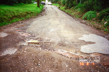
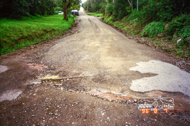
Photograph, Road surface conditions around Eltham: Looking east along Franklin Street adjacent to No. 131, 7 Aug 1996, 1996
... Shows sections of Franklin, John and Napoleon streets were... melbourne Shows sections of Franklin, John and Napoleon streets were ...Shows sections of Franklin, John and Napoleon streets were still unmade as of late 1996 and the condition of those roads with potholes at the intersections with Bible Street.Reflects on the changing nature of the local street-scape and housesRoll of 35mm colour negative film, 7 stripsKodak Gold 100-5eltham, napoleon street, bible street, franklin street, john street -
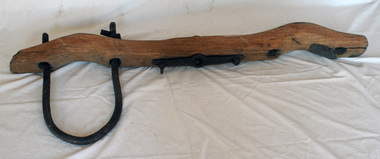 Orbost & District Historical Society
bullock yoke
Yokes like this one were key components used to control bullock teams. These teams were very important in Australia during the 19th century, hauling heavy loaded wagons of goods to remote settlements and rural produce to cities and ports over rough unmade roads. The bullocks were yoked together in pairs. Chains joined the yoked pairs. A heavy wooden bullock yoke with only one metal collar. One is missing. The fittings are iron. There is a small leather patch tacked on to one end. The yoke is made from a length of wood of roughly rectangular cross-section. It has been shaped to form curved depressions that allow it to rest across the necks of two bullocks and yoke them together. bullock-yokes transport -
 Ringwood and District Historical Society
Photograph, Barkly Street, Ringwood - c1948
Black and white photograph of unmade road in poor condition. Houses in background.Typed below photograph, "Barkly St., Ringwood c.1948". Catalogue card states, "Taken about 100 yards down from Wantirna Road. Car probably going south along Wantirna Road. House far right now block of flats (Sept. 1975) but next two houses up street are there. Haig St. just behind car. Fence on house to left still there and curved front path. Shop visible corner Haig St. to left of big pole still there." -
 Ringwood and District Historical Society
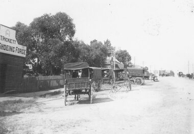
Photograph, Outside the Ringwood Market in Maroondah Hwy. 1925
... Black and white photograph of street scene showing unmade... of street scene showing unmade road with horses and carts ...Black and white photograph of street scene showing unmade road with horses and carts at roadsides and wooden buildings to left of photograph. (2 copies)Typed below photograph, "Outside the Ringwood Market in Maroondah Hwy. 1925. Shop in centre (is) at corner of Ringwood Street. ... ". -
 Flagstaff Hill Maritime Museum and Village
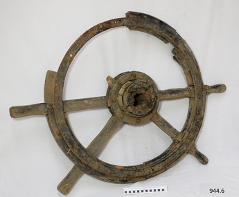
Equipment - Ship's Wheel, 1922
This ship's wheel was hand made from wood and metal using a recycled cart wheel. It originally belonged to the "Reginald M", a 2 masted, flat bottomed, coastal trading ketch with single chine. The REGINALD M The vessel “Reginald M” was a two-masted coastal ketch, owned and built by Mr. Jack (John) Murch of Birkenhead, Port of Adelaide, South Australia. Its construction took approximately 6 months and it was launched at Largs Bay in 1922. The Reginald M’s purpose was to serve the coastal trade of South Australia, to carry cargo cheaply and efficiently. It is believed that the keel was in fact hewn from two telegraph poles! Its builder frequented all the salvage yards for materials and fittings. Reginald M had a very shallow draft and a flat bottom that enabled it to come close to shore and to sit high and dry at low tide or to be beached on sand. The flat bottom was also to make the ship able to skim over reefs. Wagons could load and unload direct from her side. Her cargo included Guano, Barley, Wool, Horses, Cattle, Timber, Explosives, Potatoes, Shell Grit and Gypsum. On April 9th 1931Reginald M weathered a large storm in St Vincent Gulf, SA. The vessel suffered much damage; mast snapped and the crew laboured for four hours to free her by chopping off the past and rigging. The crew patched her up and slowly returned to Port Adelaide with only a portion of the insured cargo being damaged. Her crew members at the time were owner Mr John H Murch of Wells Street Largs Bay, Skipper Mr R Murch – John’s brother, Murray – son of Captain Murch and Seaman John Smith. Reg Webb purchased Carribie Station, at Marion in the Warooka District, south of Adelaide, in 1921. He cleared the land and farmed sheep and grain. In 1923 he shipped his own wool and grain from Marion Bay, having first carted 300 bags of the barley grain, 12 bags at a time, along the unmade track to the jetty. A photograph donated to Flagstaff Hill, dating about 1929 - 1942, shows two men on the Reginald M, holding between them their fishing catch of a large hammer shark. The photograph is stamped “GRENFELL STUDIO PORT LINCOLN PRINT” and titled “hammer shark caught on Reginald Emm”. The donor’s family lived on the Your Peninsular and despatched their grain from a chute at Gleeson’s Landing to the awaiting transport vessel. Reg knew the Murch Brothers from Port Adelaide. The brothers had been using their ketch REGINALD M to ship Guano from the Islands, led by Captain Richard Murch. Reg approached them in 1934 about shipping grain from Marion Bay. The brothers visited the bay and thought it was an ideal place. They showed Reg where to stack his grain and they measured up the cliffs. When Reg was ready, they brought down and installed a ninety foot wooden chute. The bags of grain were then individually sent down the chute, landing in a waiting small boat then rowed to REGINALD M, 14 bags at a time. After 10 hours REGINALD M would be fully loaded with 1300 bags of grain and shipped to waiting ports. At one time a wild storm destroyed the chute but it was rebuilt and strengthened. REGINALD M was involved in shipping the grain from there until 1938. In 1940 Able Seaman Allan H Lucas served on Reginald M between September and December, being engaged and discharged from Port of Adelaide. His Certificate of Discharge was signed by ship’s Master W S Murch. It seems that at some stage Reginald M was used as a Customs vessel, as one photograph in Flagstaff Hill’s collection shows “H.M.C. No. 3, Pt Adelaide” on the bow. In 1969 the last freight left Marion Bay on the ketch REGINALD M carrying grain, wool and explosives. In late 1970 she was sold to the Mt. Lyell Mining and Railway Company and was used by them as a barge to carry explosives. In 1972 the Navy League of Strahan, Tasmania, purchased her for use by the Strahan Sea Cadet Unit to use at Macquarie Harbour and renamed her T.S. Macquarie. However this plan for use of Reginald M did not come to pass. In 1974 Mr. Andrew Rennie, of East Brighton, Melbourne, bought her for a similar purpose. , paying $5,000 and donating a ‘Cadet of the Year” trophy to the Sea Cadets. He sailed her from Strahan to Melbourne, planning to use her for pleasure sailing. Also in 1975 Reginald M was sold to Melbourne Ferry Company at auction. Later in 1975 the Reginald M was bought by Flagstaff Maritime Museum for $20,000 . She has been restored and is now one of the exhibits in the Village lagoon or lake. It was restored in 2006 using funds from a $4,000 government grant. This ship's wheel is significant because of its association with the REGINALD M. REGNIALD M was a coastal trading ketch from South Australia built in 1922. It is one of very few sailing coastal trading vessels still extant, and its flat bottom, single chine shape illustrates a very simple but robust method of construction, compared to other round bilged examples of trading vessels. She is now listed on the Australian Register of Historic Vessels (ARHV Number: HV000562.)Ship’s wheel, also called a Helm, eight spoke design. Centre of wheel is handmade of wood and has iron rings around each side. The spokes are fitted into this wooden hub. The outer wheel has an iron ring on one side and sections of a wooden ring on the other. There are both original and modern bolt and screw fastenings. The wheel has remnants of black paint. This ship’s wheel was originally fitted to the ketch REGINALD M and removed during its restoration. flagstaff hill, warrnambool, shipwrecked-coast, flagstaff-hill, flagstaff-hill-maritime-museum, maritime-museum, shipwreck-coast, flagstaff-hill-maritime-village, ship's wheel, hand made ship's wheel, coastal trader, reginald m, ketch, john murch, ch murch, reg webb, carribie station, mt lyell copper company, queenstown navy league, andrew rennie, melbourne ferry company, r.f. dale -
 Federation University Historical Collection
Photograph - Photograph (Black & White), Mines Department, Back View School of Mines Ballarat, c 1900
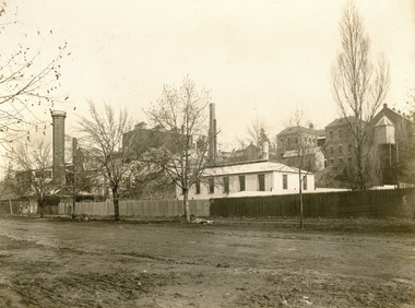
... , and Albert Street is an unmade dirt road.... Laboratory. The buildings shown along Albert Street have been ...The Albert Street end of the Ballarat School of Mines Campus included the Gauge Tower [designed by Henry R. Caselli] and the Mining Laboratory. The buildings shown along Albert Street have been demolished to make way for the M.B. John Building and the Flecknoe Building. Black and white photograph mounted onto green card. Shows the Ballarat School of Mines from Albert Street. The Henry Caselli designed Gauge tower is located on the left hand side of the photo, and Albert Street is an unmade dirt road.Written onto bottom of photo 'Back View School of Mines Ballarat. Mines Dept.ballarat school of mines, albert street, henry caselli, henry richards caselli, hr caselli -
 Bendigo Historical Society Inc.
Photograph - LA TROBE UNIVERSITY BENDIGO COLLECTION: BENDIGO TEACHERS' COLLEGE BUILDINGS
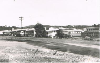
A black and white photograph of the new Bendigo Teachers' College in Osborne Street. Two A.V. Jennings signs can be seen on the side of the buildings. A Holden car is parked in front of the building. An unmade road is in the foreground. 1959.bendigo, education, bendigo teachers' college, la trobe university bendigo collection, collection, bendigo, education, buildings, tertiary education, bendigo teachers' college, teacher training, photograph, photographs, photography -
 Bendigo Historical Society Inc.
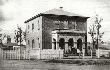
Photograph - WATCHHOUSE: SANDHURST, 1861
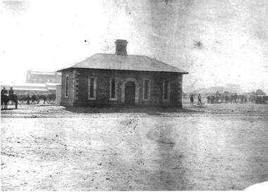
Black and white reprint of Batchelder: watchhouse ( James Lerk 28.2.2000 ) , Market Square. Drays loaded with sacks both left and right. Brick building central chimney. Unmade roadway. Brick building with central arched doorway and 2 narrow windows each side of door. 1 window on Lh end of building. Contrast colour brick quoins around windows and door.batchelderbuildings, government, watch house, sandhurst -
 Bendigo Historical Society Inc.
Photograph - METROPOLITAN HOTEL BENDIGO, 1861 ?
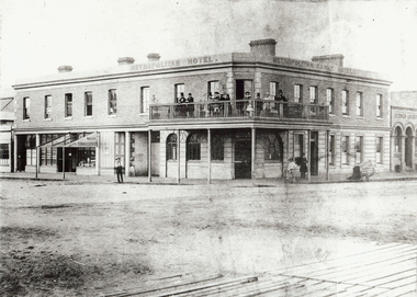
Black and white photo (copy). Metropolitan Hotel, Cnr. Bull Street and Hargreaves St., Bendigo. Also signed Metropolian Family Hotel. Two storey brick building with balcony around corner of building. Gentlemen in top hats and ladies standing on balcony. Unmade road in foreground. Boardwalk visible in front of photo. On LH side of building on ground floor : 'Bailes Tobacconist' sign on veranda over doorway (no roofing on verandah) Batchelder cart on RH side of photo. Photo taken in 1861. See Research field for further information.Batchelderbuildings, hotel, metropolitan hotel, metropolitan hotel. hargreaves street. bull street. batchelder, benjamin pierce. hotels. -
 Bendigo Historical Society Inc.
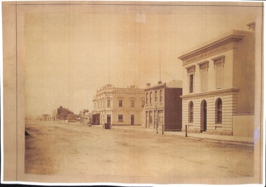
Photograph - GOVERNMENT SURVEYOR'S OFFICE: VIEW STREET, BENDIGO, late 1850's
black and white photo ( copy ): Brick two storey building, with three arched portico at front. Picket fence on side front of building, with railed fence at front. Road is unmade. Tree to RH side of building, small brick building visible to LH side read of building.organization, government, surveyor's office -
 Bendigo Historical Society Inc.
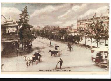
Photograph - HARGREAVES STREET BENDIGO
sepia image : image shows Hargreaves Street Bendigo, looking north. On RH side Golden Key Boot Co., printed on verandah blind. Cattran? On LH side of same. Williams Shoemen on LH side. Tress lining either side of street, horse and gigs on road, which appears to be unmade. Printed on bottom 'Hargreaves Street, Bendigo'bendigo, streetscape, hargreaves street, bendigo, sandhurst, hargreaves street, golden key boot co. -
 Port Melbourne Historical & Preservation Society
Photograph - Bay Street, Charles Nettleton, Charles Nettleton, 1878-79
... Street Mounted Charles NETTLETON original: looking northeast ...This photograph can be dated to 1878-79 because according to Chartered Scoundrel's by Pat Grainger, Scott's Hotel only operated during those years. The National Bank of Australasia at the right of the photograph was designed by Leonard TERRY of Terry and Oakden, Architects and was constructed in 1874. It was subsequently extended to a design by architect George JOBBINS in 1889. See Cat No 197 for a photograph of the altered building.Mounted Charles NETTLETON original: looking northeast in Bay Street: National Bank of Australiasia, grocery shop, Scotts Hotel, trees at Holy Trinity, George Hotel, unmade roadnational bank of australasia, charles nettleton, built environment - commercial, scott's hotel, bay street -
 Port Melbourne Historical & Preservation Society
Photograph - Bay Street, looking northeast, Charles Nettleton, 1878
Mounted Nettleton original: looking northeast in Bay Street: National Bank of Australia, grocery shop, Scotts Hotel, trees at Holy Trinity, George Hotel, unmade road. This is a copy of the larger original at B.11.09built environment - commercial, charles nettleton -
 Bendigo Historical Society Inc.
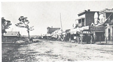
Photograph - HARRY BIGGS COLLECTION: BENDIGO PALL MALL, 1850's
Photograph. Harry Biggs Collection. Black and white photo of Bendigo. Pall Mall area, looking north. The unmade road has a line of shops to the right. - K Van Damme Tobacconist is in the foreground as is Cobb & Co booking office. Above the tobacconist is the sign Morey & Snow. 2 men are standing above a shop. Horse & carts are parked in front of the shops. Trees are to the left.place, building, commercial, harry biggs collection, bendigo pall mall -
 Hume City Civic Collection
Photograph, c1960s
The photograph overlooks former railway land along Vineyard Road which is now a commercial and light industrial estate. It was taken before curbing and footpaths were laid and Vineyard Road was narrow strip of asphalt with the sides of the road unmade.A black and white photograph of Vineyard Road with the Sunbury Railway line visible across the middle distance and the former Sunbury Asylum site in the background.vineyard road, sunbury asylum, sunbury railway line, george evans collection -
Clunes Museum
Map - MAPS
ORIGINAL MAP SHIRE OF TALBOT AND CLUNES. LOCALITY PLAN, SEALED ROADS, BITUMEN ROADS, GRAVEL OR SAND ROADS, UNMADE OR PART FORMED ROADS.local history, document, maps, talbot, clunes shire -
 Whitehorse Historical Society Inc.
Photograph, Jeffery Street Blackburn. Taken 1969, 1/06/1969 12:00:00 AM
... B/W photo of Jeffery Street, Blackburn deliberately left... Street, Blackburn deliberately left unmade. Taken in 1969 ...B/W photo of Jeffery Street, Blackburn deliberately left unmade. Taken in 1969jeffery street, blackburn -
 Whitehorse Historical Society Inc.
Photograph, Jeffery Street Blackburn, 1/06/1969 12:00:00 AM
... B/W photo of Jeffery Street, Blackburn deliberately left... Street, Blackburn deliberately left unmade. Taken in 1969 Jeffery ...B/W photo of Jeffery Street, Blackburn deliberately left unmade. Taken in 1969jeffery street, blackburn -
 Rutherglen Historical Society
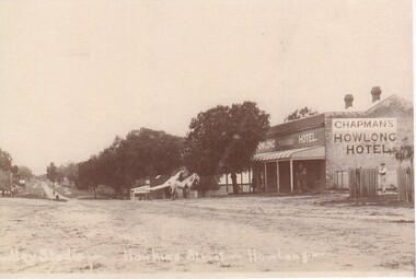
Photograph - Image, c1900
... Black and white photograph showing a street view..." Black and white photograph showing a street view of an unmade ...Black and white photograph showing a street view of an unmade road, featuring Chapman's Howlong Hotel. Man on horseback is near the front of the hotel.At bottom of photo is a very faint inscription: " [illeg.] Hawkins Street, Howlong"hotels, howlong hotel, chapman, howlong -
 Whitehorse Historical Society Inc.
Photograph, Till house, Clive Street, Mitcham
... Street, Mitcham. Picket fence, unmade road and a small boy... Mitcham melbourne clive street mitcham till family. Black ...Black and white photograph of the Till house in Clive Street, Mitcham. Picket fence, unmade road and a small boy at the gate.clive street, mitcham, till family. -
 Whitehorse Historical Society Inc.
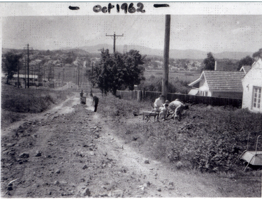
Photograph, Good Governs Street, Mitcham, 1962
... Governs Street, Mitcham, which is unmade. Two figures working... maintaining Good Governs Street, Mitcham, which is unmade. Two figures ...People maintaining Good Governs Street are Arthur Roberts, John Kift, Cliff Bellamy and Doug Sawyer.Black and white photograph of people maintaining Good Governs Street, Mitcham, which is unmade. Two figures working on the road and a group near a pole on the right.good governs street, mitcham -
 Hume City Civic Collection
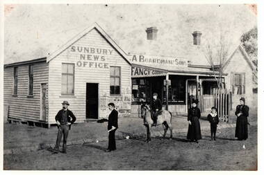
Photograph, Sunbury News Office
The Boardman family were local business people in Sunbury, who were storekeepers and also produced the local newspaper. Their original building was in Brook Street near the railway station but they later located their business further down in Brook Street on the corner of O'Shanassy Street. A black and white photograph with a cream border of a news office, store and cottage with a picket fence. The buildings are weatherboard with corrugated iron roofs.A young tree surrounded by a tree guard has been planted on the footpath between the cottage and shop.Two men and two ladies and a boy are standing in front of the buildings on the unmade road. A boy on horseback is alsoweith the group.j.a. boardman, sunbury news office, businesses., brook street -
 Sunbury Family History and Heritage Society Inc.
Photograph, c 1940s
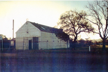
The building was the former Sunbury Fire Station. It was in Evans Street on the site where the shopping square has been built. Mount Holden can be seen in the background. A newer building was built for the CFA on the opposite side of Evans Street and closer to Macedon Street. As the shopping centre expanded and Sunbury grew, the CFA moved from the town centre to a site in Jackson Street and another one in Elizabeth Drive.Over the years the CFA has played an important role in numerous fire fighting activities over summer months.A scanned coloured photograph with a fine white border of an old weatherboard building with a metal roof by an unmade roadway. A hill is in the background and two bare trees are growing near the building.sunbury cfa.