Showing 42 items
matching vegetation study
-
 Kew Historical Society Inc
Photograph - Willsmere [Kew] Billabong, 1993
Willsmere Park is bounded by the the Yarra River, Green Acres Golf Club, Willow Grove and the Eastern Freeway. The land on which the park is now situated was bought by Thomas Wills at the Crown Land Sales of 1846 (Section 56). From the 1840s to the 1940s it was intensively farmed. The park is dominated by very large playing fields, while planting to the southern boundary was undertaken when the Eastern Freeway was built. It is only along the banks of the Yarra that there is any remnant native vegetation. Willsmere Park is of significance as an area of open land that remains from the flood plain that once dominated northern Kew. (Source: Kew Conservation Study, 1988)Original colour small format polaroid photograph of the 'Kew Billabong' in the Willsmere Park, taken on 16 September 1993."Willsmere Billabong 16.9.93"kew billabong, willsmere park, yarra river -- billabongs -
 Kew Historical Society Inc
Photograph - Yarra River in flood at the Willsmere Park, 1993
Willsmere Park is bounded by the the Yarra River, Green Acres Golf Club, Willow Grove and the Eastern Freeway. The land on which the park is now situated was bought by Thomas Wills at the Crown Land Sales of 1846 (Section 56). From the 1840s to the 1940s it was intensively farmed. The park is dominated by very large playing fields, while planting to the southern boundary was undertaken when the Eastern Freeway was built. It is only along the banks of the Yarra that there is any remnant native vegetation. Willsmere Park is of significance as an area of open land that remains from the flood plain that once dominated northern Kew. (Source: Kew Conservation Study, 1988)Original colour small format polaroid photograph of the Yarra River in flood at the Willsmere Park, taken on 16 September 1993."Yarra River at Willsmere Park Flooding 16.9.93"willsmere park, yarra river -- floods -- kew (vic.) -
 Kew Historical Society Inc
Photograph - Flooding in the Willsmere Park, 1993
Willsmere Park is bounded by the the Yarra River, Green Acres Golf Club, Willow Grove and the Eastern Freeway. The land on which the park is now situated was bought by Thomas Wills at the Crown Land Sales of 1846 (Section 56). From the 1840s to the 1940s it was intensively farmed. The park is dominated by very large playing fields, while planting to the southern boundary was undertaken when the Eastern Freeway was built. It is only along the banks of the Yarra that there is any remnant native vegetation. Willsmere Park is of significance as an area of open land that remains from the flood plain that once dominated northern Kew. (Source: Kew Conservation Study, 1988)Original colour small format polaroid photograph of flooding in the Willsmere Park, taken on 16 September 1993."Flooding of shared path from Willsmere Billabong 16.9.93"willsmere park, yarra river -- floods -- kew (vic.), kew billabong -
 Kew Historical Society Inc
Photograph - Flooding in the Willsmere Park, 1993
Willsmere Park is bounded by the the Yarra River, Green Acres Golf Club, Willow Grove and the Eastern Freeway. The land on which the park is now situated was bought by Thomas Wills at the Crown Land Sales of 1846 (Section 56). From the 1840s to the 1940s it was intensively farmed. The park is dominated by very large playing fields, while planting to the southern boundary was undertaken when the Eastern Freeway was built. It is only along the banks of the Yarra that there is any remnant native vegetation. Willsmere Park is of significance as an area of open land that remains from the flood plain that once dominated northern Kew. (Source: Kew Conservation Study, 1988)Original colour small format polaroid photograph of flooding in the Willsmere Park, taken on 16 September 1993."Flooding of Willsmere Park from Yarra 16.9.93"willsmere park, yarra river -- floods -- kew (vic.) -
 Kew Historical Society Inc
Photograph - Flooding of Willsmere Park from Yarra, 1993
Willsmere Park is bounded by the the Yarra River, Green Acres Golf Club, Willow Grove and the Eastern Freeway. The land on which the park is now situated was bought by Thomas Wills at the Crown Land Sales of 1846 (Section 56). From the 1840s to the 1940s it was intensively farmed. The park is dominated by very large playing fields, while planting to the southern boundary was undertaken when the Eastern Freeway was built. It is only along the banks of the Yarra that there is any remnant native vegetation. Willsmere Park is of significance as an area of open land that remains from the flood plain that once dominated northern Kew. (Source: Kew Conservation Study, 1988)Original colour small format polaroid photograph of flooding in Willsmere Park resulting from heavy rain on 15 September 1993."Flooding of Willsmere Park from Yarra 16.9.93"yarra river -- floods -- kew (vic.), willsmere park -
 Kew Historical Society Inc
Photograph - Willsmere [Kew] Billabong, 1993
Willsmere Park is bounded by the the Yarra River, Green Acres Golf Club, Willow Grove and the Eastern Freeway. The land on which the park is now situated was bought by Thomas Wills at the Crown Land Sales of 1846 (Section 56). From the 1840s to the 1940s it was intensively farmed. The park is dominated by very large playing fields, while planting to the southern boundary was undertaken when the Eastern Freeway was built. It is only along the banks of the Yarra that there is any remnant native vegetation. Willsmere Park is of significance as an area of open land that remains from the flood plain that once dominated northern Kew. (Source: Kew Conservation Study, 1988)Original colour small format polaroid photograph of Willsmere [Kew] Billabong on September 1993."Willsmere Billabong 16.9.93"yarra river -- floods -- kew (vic.), willsmere park -
 Lakes Entrance Historical Society
Book, Calder Stuart and Winty, Lake Bunga Foreshore Reserve its life and Landscape, 1985
... A study of the topography, vegetation and fauna of the Lake...Topography Vegetation Natural History A study ...A study of the topography, vegetation and fauna of the Lake Bunga Victoria area, and relationship with the coastal environment. Revised edition 1985topography, vegetation, natural history -
Lakes Entrance Historical Society
Book, Land Conservation Council Victoria East Gippsland Study Area, 1974
Report describing the nature of environmental features, together with the character and distribution of various natural resources of the East Gippsland, Victoria, study area, comprising land in the old Shire of Orbost. History, vegetation, flora, fauna,vegetation, natural history, vegetation -
 Lakes Entrance Historical Society
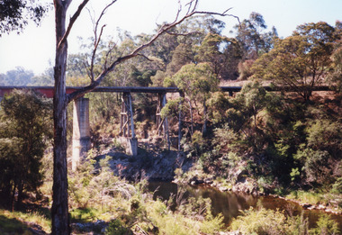
Photograph - Bridges, 1998
Re Heritage StudyColour photograph of the railway bridge over Boggy Creek, showing the bridge high above the waterway, rocky terrain and scrubby vegetation. Nowa Nowa, Victoria,bridges, waterways, transport -
 Lakes Entrance Historical Society
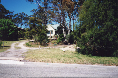
Photograph - Housing, Holding M, 1999
Appears to have been relocated from unknown site, more research required.Colour photograph of a timber dwelling. Has high pitched corrugated iron roof, decorative timber frieze under pitch of gable over front room. Steps leading up to veranda. Set in native vegetation, at 6 Worcester Street, Lakes Entrance Victoriaaccommodation, houses, heritage study -
Lakes Entrance Historical Society
Book, Land Conservation Council Victoria South Gippsland Area District 2, 1980
Report describing and assessing the natural resources of the public land in the South Gippsland (Victoria) Study Area 2, comprising the Latrobe Valley, Strzelecki Range, South Gippsland coastal plains and all of Wilson's Promontory. History, Geology, floRuth Clarkgippsland, topography, natural history, vegetation -
Lakes Entrance Historical Society
Book, Land Conservation Council Victoria Gippsland Lakes Hinterland Area, 1982
Report describing the physical nature of the land in the Gippsland Lakes (Victoria) Hinterland Study area. History, climate, geomorphology, land use, flora and fauna are presented. 1 map in pocket.waterways, gippsland, natural history, vegetation