Showing 178 items
matching viaduct
-
 Malmsbury Historical Society
Photograph (Item), Mhs Members At Viaduct 150Th Exhibition October 2010, Malmsbury 24/10/2010
People - Bransgrove Walter Tynan Faulks Thomas Penno Buildings - Mechanics Institute Associated with - Mhs Mechanics Institute -
Malmsbury Historical Society
Photograph (Item), Mhs Members At Viaduct 150Th Exhibition October 2010, Malmsbury 24/10/2010
People - Bransgrove Walter Tynan Faulks Thomas Penno Buildings - Mechanics Institute Associated with - Mhs Mechanics Institute -
 Malmsbury Historical Society
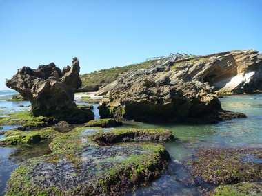
Photograph (Item), River View Near Viaduct, Malmsbury ca1930
Buildings - Malmsbury Mill -
 Malmsbury Historical Society
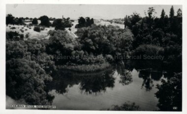
Postcard (Item), Railway Viaduct Over Coliban River At Malmsbury, Malmsbury ca1940
Buildings - Coliban River & Malmsbury Mill -
Malmsbury Historical Society
Photograph (Item), Exhibition Of Memorabilia 1990 Viaduct, Malmsbury ca1990
Associated with - M.H.S. Buildings - Mechanics Institute People - "Bates, A" -
 Victorian Railway History Library
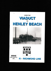
Book, Australian Electric Transport Museum (SA) Inc, Over the viaduct to Henley beach, 1997
The story of the horse and electric tramway to Henley beachIll, p.20.non-fictionThe story of the horse and electric tramway to Henley beachtramways - adelaide, horse tramways - adelaide -
 Ringwood and District Historical Society
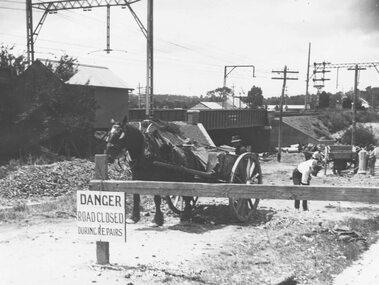
Photograph, Construction of railway viaduct in Pitt Street, Ringwood - circa 1923, south side looking east
Black and White photograph (2 copies)Type below one copy: "Making Warrandyte Rd Subway, 1923 Taken from Pitt St." -
 Ringwood and District Historical Society
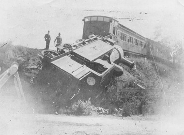
Photograph, Ringwood derailment 1902 at Wantirna Rd. railway viaduct
Black and white photographs - 2 copies - 1 large and 1 smallWritten on backing sheet, "Ringwood 11/2/1908. EE478". Another copy is dated "1902" taken from a different angle and it appears to be the same engine as in previous photographs with the 1908 date. -
 Orbost & District Historical Society
black and white photographs, 15th February 1971
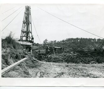
The 1971 flood was the the worst flood on record. At Jarrahmond it was at least 11 metres and up to one and a half kilometres wide on the flats causing enormous damage to the flood plain. Records say that "The brown floodwater stain in Bass Strait could be seen from passing airliners." Considerable damage was done to railway infrastructure, roads and farms. More information from the APRIL, 2008 newsletter by John Phillips. (see orbosthistory.com.au) The railway line was destroyed and was not expected to be opened for a fortnight. Orbost was cut off by 50 square miles of Snowy River floodwater. These photographs are pictorial records of the 1971 floods which was a significant event in the history of Orbost. They are also associated with the East Gippsland Railway.Three black / white photographs of flood debris and flood waters near a railway line. 3102.l has a pile driver 3102.2 shows a gap in the viaduct and 3102.3 shows men with a tractor cleaning up the debris,3102.1 - on back - "1971 FLOOD REPAIRS TO ORBOST RAILWAY VIADUCT - 15th February 1971. Donated by Audrey Van Den Berg VRH 3693" 3102.2 - on back - " DAMAGE TO RAILWAY VIADUCT ACCUMULATED DEBRIS" 3102.3 - on back - "DAMAGE TO RAILWAY VIADUCT AT ORBOST. CLEAN UP BEGINS"orbost-flood-1971 orbost-viaduct-flood-damage orbost-railway -
 Whitehorse Historical Society Inc.
Booklet - Catalogue of Tools and Machines, Hand Tool Preservations Association of Australia Inc
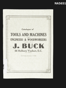
Catalogue of Tools and Machines for Engineers and Woodworkers. Book describes tools, with components and measurements for various parts. This catalogue is a reprint by HTPAA (Hand Tool Preservation Association of Australia Inc) from the original catalogue produced by J. Buck 56 Holborn Viaduct E. C. which was established 1750.J. Buck 56 Holborn Viaduct E. C. tools & machines, j. buck, engineers & woodworkers -
 Hume City Civic Collection
Photograph
This image is of the Viaduct at Rupertswood across the Jacksons CreekA black and white photo of the viaduct at Rupertswood across the Jackson's Creek with several gum trees in the foreground. There are electric power lines along the railway line.rupertswood, jackson's creek, railways, bridges, george evans collection -
 Orbost & District Historical Society
black and white photograph, Vogt. W.S, first half 20th century
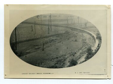
In 1912 work was underrway on the Bairnsdale to Orbost railway. It was opened on April 10 1916. The two bridges on the railway viaduct, which crosses the Snowy River floodplain at Orbost, were built from local Southern Mahogany. The bridge on the Bairnsdale end (770m) is now the longest in Victoria. (info. Helen Martin)This item is associated with the history of the Orbost-Bairnsdale railway line and therefore reflects the role that the rail line played in the social and economic history of Orbost.A black / white photograph, oval-shaped on white background. It is of the railway viaduct across the flats at Orbost,.photo caption -"ORBOST RAILWAY BRIDGE, NEWMERELLA E. S. Vogt, Bairnsdale"newmerella orbost-viaduct east-gipsland-railway -
 Orbost & District Historical Society
black and white photograph, Rose Stereograph Company, first half 20th century
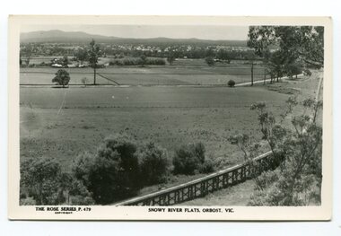
The two bridges on the railway viaduct, which crosses the Snowy River floodplain at Orbost, were built from local Southern Mahogany. The bridge on the Bairnsdale end (770m) is now the longest in Victoria. Despite various attempts to extend the line, the station stayed on the western side of the Snowy River. (info. Helen Martin)This item is associated with the history of the Orbost-Bairnsdale railway line and therefore reflects the role that the rail line played in the social and economic history of Orbost.A black / white photograph / postcard of the Orbost township in the background and the railway viaduct over the flats in the foreground.photo caption - The Rose Series P.479 copywright SNOWY RIVER FLATS, ORBOST, VIC"east-gippsland-railway orbost-viaduct -
 Hume City Civic Collection
Photograph, 1990-1999
Two viaduct bridges were constructed across the Jacksons Creek valley at Rupertswood on the Bendigo rail line to bring the trains down the steep incline into Sunbury station.A photograph of the railway viaduct bridge showing one end of the span and 4 of the pylons. This bridge crosses the Jackson's Creek near one of the waterfalls which have been constructed in the creek. A large tree trunk is in the foreground of the photograph.rupertswood, clarke, william (sir), rupert (sir), michael (sir), victorian railways, salesian college, railways, bridges, jacksons creek, sunbury railway station, sunbury, george evans collection -
 Ballarat Heritage Services
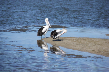
Digital photographs, L.J. Gervasoni, Warrnambool pelicans, c2015
Colour photograph of two pelicans and their refletions at the Warrnambool beach.warrnambool, merri river, pelicans, birds, estuary, coastal -
 Ballarat Heritage Services
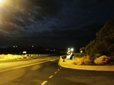
Digital photographs, L.J. Gervasoni, Warrnambool at night, c2015
warrnambool, merri river, estuary, coastal, night -
 Ballarat Heritage Services
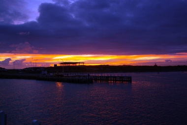
Digital photographs, L.J. Gervasoni, Harbour Pavilion under construction, c2010
warrnambool, coast, coastal, beach, seascape, harbour pavilion, construction, sunset, viaduct road, breakwater -
 Ballarat Heritage Services
Digital photographs, L.J. Gervasoni, Geology at Stingray Bay / middle island, c2010
Colour photograph of Middle Island, Warrnambool.warrnambool, landscape, seascape, ocean, water, middle island, stingray bay, geology, coastal geomorphology -
 Ballarat Heritage Services
Photograph - Digital photographs, L.J. Gervasoni, Middle Island, Warrnambool, 2012
Digital images of Middle Island Stingray Bay warrnamboolvictoria, river, mouth, coast, ocean, island, middle, middle island, warrnambool, merri, merri river -
 Ballarat Heritage Services
Photograph - Digital photographs, L.J. Gervasoni, Sunset Middle Island, Warrnambool, 2009-2012
Digital images of a sunset at Middle Island, Warrnambool. seascape, sunset, coast, coastal, landscape, middle island, merri island, stingray bay, warrnambool -
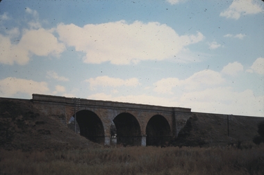
 Bendigo Historical Society Inc.
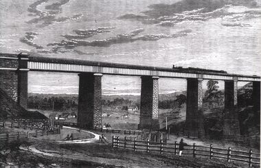
Photograph - TARADALE RAILWAY VIADUCT - ENGRAVING
Photocopy of photo: engraving shows Taradale Railway Viaduct completed. Steam train on viaduct. Stone piers supporting railway line on bridge. Underneath viaduct, post and rail fence, cottages in background.railways, bendigo to melbourne, taradale viaduct -
 Bendigo Historical Society Inc.
Photograph - MALMSBURY
DVD. Malmsbury Rail Viaduct. Township. -
 Bendigo Historical Society Inc.
Photograph - RAILWAYS COLLECTION: RAILWAY BRIDGES AND VIADUCTS
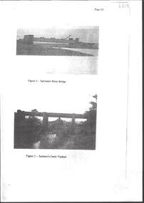
RAILWAYS COLLECTION -6 x Unbound Photocopied double sided pages giving information on the construction of the Bendigo Railway Line including Black and white photos of Railway Bridges and Viaducts - which show the Saltwater River bridge , Jacksons Creek Viaduct, Riddell Creek Bridge, Campbell's Creek Road bridge, Forest creek viaduct and Malmsbury Viaduct the photos are grainy in appearance.photograph, landscape -
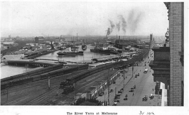 Melbourne Tram Museum
Photograph - Illustration, c1916
Illustration from a photograph reproduced in a magazine of the river Yarra, Flinders St railway yard, the viaduct, the swing basin, the wharves and Queens Bridge. Has a number of cable cars and trains in the view. Taken prior to the construction of the second or duplicate viaduct which was completed during 1915. Construction of the second viaduct on the south side of the original can be seen.in ink in bottom right hand comer "By 1916"trams, tramways, flinders st, railways, shipping, cable trams -
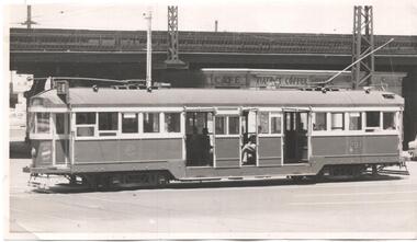 Melbourne Tram Museum
Photograph - Black & White Photograph/s, 1960's?
Black and white photograph of W2 291, eastbound in Flinders St with the Flinders St viaduct and the Viaduct Coffee Lounge shop in the background. Tram showing Route 28 (City Richmond) . No known details of the photographer or date.trams, tramways, flinders st, w2 class, route 28, tram 291 -
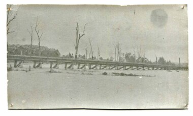 Orbost & District Historical Society
black and white photograph, January 1934
Orbost has been subject to major floods throughout its history, such as those which left the town isolated in 1934, 1952, 1971 and 1978. It is recorded that the Snowy River broke its banks and flooded the flats 104 times between 1884 and 1978. Extensive flooding in Eastern Victoria during June 1978, caused widespread damage to roads, road closures and hazards to traffic, particularly over the Queen's Birthday holiday weekend.This is a pictorial record of a significant event in Orbost's history.A very faded black / white photograph of flood water under the railway viaduct at watt's Gulch.orbost-flood-1934 railway-viaduct-orbost -
 Bendigo Historical Society Inc.
Slide - MALDON & SURROUNDING AREAS, Apr 1968
Slide. Maldon & Surrounding Areas. Brick railway bridge with train passing over. (Harcourt Viaduct)slide, maldon & surrounding areas., maldon & surrounding areas. -
 Bendigo Historical Society Inc.
Slide - MALDON & SURROUNDING AREAS, Apr 1968
Maldon & Surrounding Areas. Brick railway bridge somewhere in the district. (photo is of the Harcourt viaduct. P.W.)slide, maldon & surrounding areas., maldon & surrounding areas. -
 Kew Historical Society Inc
Photograph, Outer Circle Railway Bridge over River Yarra, c.1900
This photograph forms part of the Eric Sibly collection of images and information relating to the Outer Circle Railway which he donated to the Kew Historical Society in 1974. Heritage Victoria Citation (Abridged) "The Chandler Highway Bridge, a 137 metre wrought iron lattice-truss girder bridge with four spans supported on red brick piers with moulded bluestone cappings. The bridge has a cantilevered walkway along the west side. ...The Chandler Highway Bridge crosses the Yarra River and connects Alphington and Kew. It was completed in November 1890 as part of the Outer Circle Railway Line.Black & white photograph of the railway viaduct over Yarra River looking south towards Kew.Reverse: "Pre 1930. Outer Circle Railway Bridge over River Yarra (now Chandler Highway) - note bridge over line on Kew side for Asylum Farm". KH - 56. Kew Historical Society.chandler highway, railway bridges - kew (vic), sir john monash, outer circle railway, river yarra - kew (vic) -
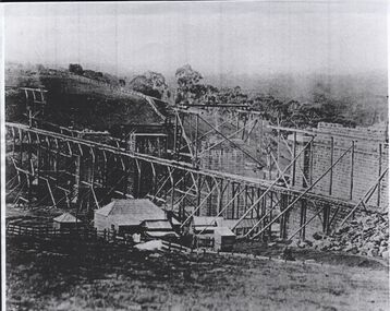 Bendigo Historical Society Inc.
Photograph - RAILWAYS: COPY OF PHOTO OF TARADALE VIADUCT UNDER CONSTRUCTION
Photocopy of photo: image shows scaffolding erected to build the Taradale viaduct. Brick piers evident, buildings at side of construction. On back of photo in pencil: Taradale Railway Viaduct under construction C 1860. Courtesy James Lerk, late Frank Cusack Collection.railways, bendigo to melbourne