Showing 1180 items matching "victoria point"
-
 Marysville & District Historical Society
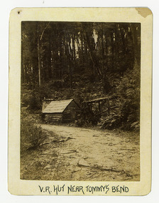
Photograph (Item) - Black and white photograph, V.R. Hut near Tommy's Bend, c1900
... Mountain. tommy's bend marysville victoria marysville-wood's point ...An early black and white photograph of a Victoria Roads worker's hut near Tommy's Bend near Marysville in Victoria. An early black and white photograph of a Victoria Roads worker's hut near Tommy's Bend near Marysville in Victoria. Tommy's Bend is a stretch of road 10 kilometres from Marysville on the Woods Point Road up to Lake Mountain.ARMSTRONG COLLECTION 42 STATION STREET/ SANDRINGHAM 3191/ TEL. (03) 9521 5442/ IAN M.L. ARMSTRONG OAMtommy's bend, marysville, victoria, marysville-wood's point road -
 Marysville & District Historical Society
Photograph (Item) - Black and white photograph, Beech Forest Beyond Tommy's Bend, c1900
... . tommy's bend marysville victoria marysville-wood's point road ...An early black and white photograph of The Beeches, which is known as the Beech Grove, near Tommy's Bend near Marysville in Victoria.An early black and white photograph of The Beeches, which is known as the Beech Grove, near Tommy's Bend near Marysville in Victoria. Tommy's Bend is a stretch of road 10 kilometres from Marysville on the Wood's Point Road up to Lake Mountain. The Beeches Rainforest Walk is a loop that starts at Taggerty Cascades before winding through Myrtle Beech and Mountain Ash woodland and is one of the many walking tracks in and around Marysville. It is accessible from Lady Talbot Drive which is a 24 kilometer scenic rainforest car journey which passes a number of walks and waterfalls in the Yarra Ranges National Park. Lady Talbot Drive is named after Lady Sarah Elizabeth, the wife of Sir Reginald Talbot, who was the Governor of Victoria from 25th April, 1904 to 6th July 1908.ARMSTRONG COLLECTION 42 STATION STREET/ SANDRINGHAM 3191/ TEL. (03) 9521 5442/ IAN M.L. ARMSTRONG OAMtommy's bend, marysville, victoria, marysville-wood's point road, beech grove, wood's point road, lake mountain, beeches rainforest walk, taggerty cascades, myrtle beech, mountain ash, lady talbot drive, lady talbot forest drive, lady sarah elizabeth talbot, sir reginald talbot -
 Marysville & District Historical Society
Booklet (Item) - Information booklet, Artworkz Tourism, The Big Culvert, Unknown
... yarra track victoria healesville wood's point goldfields jordan ...An information booklet that was produced as a guide to The Big Culvert.An information booklet that was produced as a guide to The Big Culvert. The Big Culvert is a historic granite and bluestone arch along the Yarra Track, a major route to Melbourne through the 1800s. Built in 1870 and a major piece of infrastructure for its time, the heritage listed culvert allowed water to flow under often-flooded the road. The Yarra Track is the former name of the gold fields road from Healesville to the Woods Point and Jordan Goldfields, in Victoria, Australia. A direct route via the Yarra River and the Great Divide was discovered by Rieck in September 1862 and became known as the Yarra Track. Early in 1863, the Victorian Government decided to construct a 193-kilometre (120 mile) road along the route. Its original width varied between 4 and 6 metres (12 and 20 feet), and was designed to accommodate horse-drawn vehicles. The Track involved the climbing of the Black Spur, descent into the Acheron Valley, and then through Marysville to the Cumberland where it followed the existing route.the big culvert, yarra track, victoria, healesville, wood's point goldfields, jordan goldfields, black spur, acheron valley, cumberland valley -
Marysville & District Historical Society
Flyer (Item) - Information flyer, Artworkz Tourism, The Big Culvert, 26-03-2016
... Healesville to the Woods Point and Jordan Goldfields, in Victoria ...An information flyer that was produced as a guide to The Big Culvert.An information flyer that was produced as a guide to The Big Culvert. The Big Culvert is a historic granite and bluestone arch along the Yarra Track, a major route to Melbourne through the 1800s. Built in 1870 and a major piece of infrastructure for its time, the heritage listed culvert allowed water to flow under often-flooded the road. The Yarra Track is the former name of the gold fields road from Healesville to the Woods Point and Jordan Goldfields, in Victoria, Australia. A direct route via the Yarra River and the Great Divide was discovered by Rieck in September 1862 and became known as the Yarra Track. Early in 1863, the Victorian Government decided to construct a 193-kilometre (120 mile) road along the route. Its original width varied between 4 and 6 metres (12 and 20 feet), and was designed to accommodate horse-drawn vehicles. The Track involved the climbing of the Black Spur, descent into the Acheron Valley, and then through Marysville to the Cumberland where it followed the existing route.the big culvert, yarra track, victoria, healesville, wood's point goldfields, jordan goldfields, black spur, acheron valley, cumberland valley -
 Marysville & District Historical Society
Photograph (Item) - Black and white photograph, Unknown
... Point and Jordan Goldfields, in Victoria, Australia. A direct ...A black and white photograph taken at the unveiling of the sign placed at The Big Culvert.A black and white photograph taken at the unveiling of the sign placed at The Big Culvert. The Big Culvert is a historic granite and bluestone arch along the Yarra Track, a major route to Melbourne through the 1800s. Built in 1870 and a major piece of infrastructure for its time, the heritage listed culvert allowed water to flow under often-flooded the road. The Yarra Track is the former name of the gold fields road from Healesville to the Woods Point and Jordan Goldfields, in Victoria, Australia. A direct route via the Yarra River and the Great Divide was discovered by Rieck in September 1862 and became known as the Yarra Track. Early in 1863, the Victorian Government decided to construct a 193-kilometre (120 mile) road along the route. Its original width varied between 4 and 6 metres (12 and 20 feet), and was designed to accommodate horse-drawn vehicles. The Track involved the climbing of the Black Spur, descent into the Acheron Valley, and then through Marysville to the Cumberland where it followed the existing route.Unveiling of sign/ at "Big Culvert" In front Max Cockerrell and - Rear: second back Geoff Pope R.H.S. rear: Nancy "/ Anne "the big culvert, yarra track, victoria, healesville, wood's point goldfields, jordan goldfields, black spur, acheron valley, cumberland valley -
 Marysville & District Historical Society
Photograph (Item) - Colour photograph, 20-09-2008
... Point and Jordan Goldfields, in Victoria, Australia. A direct ...A colour photograph of the entrance to The Big Culvert.A colour photograph of the entrance to The Big Culvert. The Big Culvert is a historic granite and bluestone arch along the Yarra Track, a major route to Melbourne through the 1800s. Built in 1870 and a major piece of infrastructure for its time, the heritage listed culvert allowed water to flow under often-flooded the road. The Yarra Track is the former name of the gold fields road from Healesville to the Woods Point and Jordan Goldfields, in Victoria, Australia. A direct route via the Yarra River and the Great Divide was discovered by Rieck in September 1862 and became known as the Yarra Track. Early in 1863, the Victorian Government decided to construct a 193-kilometre (120 mile) road along the route. Its original width varied between 4 and 6 metres (12 and 20 feet), and was designed to accommodate horse-drawn vehicles. The Track involved the climbing of the Black Spur, descent into the Acheron Valley, and then through Marysville to the Cumberland where it followed the existing route.the big culvert, yarra track, victoria, healesville, wood's point goldfields, jordan goldfields, black spur, acheron valley, cumberland valley -
 Federation University Historical Collection
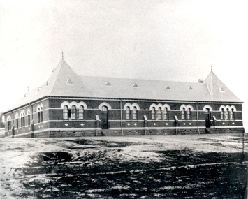
Photograph - black and white, Golden Point State School, Ballarat
... Golden Point, Victoria, Australia ...Photograph of a brick building known as Golden Point Primary School.education, school, golden point primary school -
 Phillip Island and District Historical Society Inc.
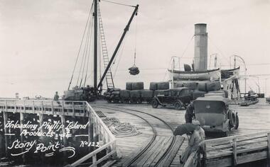
Photograph
... Stony Point, Victoria, Australia ...One of a collection of over 400 photographs in an album commenced in 1960 and presented to the Phillip Island & Westernport Historical Society by the Shire of Phillip IslandPhotograph looking down the Stony Point Jetty with the S.S."Killara" being unloaded by Derrick.local history, photography, photographs, maritime technology, cargo handling, stony point jetty with s, "killara" background, shipping, steam ships, ss killara, stony point, phillip island produce, john jenner, bryant west -
Port Melbourne Historical & Preservation Society
Letter - T L Winchombe at Crib Point Naval station to his daughter Lily Winchcombe, 3 Dec 1915
... Crib Point, Victoria, Australia ...One of two handwritten letters dated 3.12.1915, written by T.L. Winchcombe at Crib Point Naval station to daughter Lily Winchcombe. Copy of letter typed by donor is also included.On the other side of last page 'from dear Dad on my 15th Birthday'war - world war i, leslie g pont, lily winchcombe pont, t l winchcombe. -
Port Melbourne Historical & Preservation Society
Letter - T L Winchombe at Crib Point Naval station to his daughter Lily Winchcombe, 5 Dec 1916
... Crib Point, Victoria, Australia ...One of two handwritten letters; dated 5.12.1916, written by T.L. Winchcombe at Crib Point Naval station to daughter Lily Winchcombe. Copy of letter typed by donor is also included.war - world war i, leslie g pont, lily winchcombe pont, t l winchcombe. -
Port Melbourne Historical & Preservation Society
Photograph - T L Winchcombe with penny-farthing bicycle, 1915
... Crib Point ?, Victoria, Australia ...Small photocard of Mr T.L. Winchcombe, standing alongside and holding up a penny-farthing bicycle, made by Stewart & Co, Melbourne c1915Stewart & Co Melbourne (on front); details of photographers on back. Also handwritten, 'My father'war - world war i, leslie g pont, lily winchcombe pont, t l winchcombe. -
Port Melbourne Historical & Preservation Society
Photograph - Group of people at a picnic, 1915
... Crib Point ?, Victoria, Australia ...Faded sepia photograph of group of 16 unidentified people at a picnic, with covered wagon in backgroundsocial activities, leslie g pont, lily winchcombe pont -
 Ballarat Heritage Services
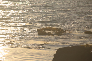
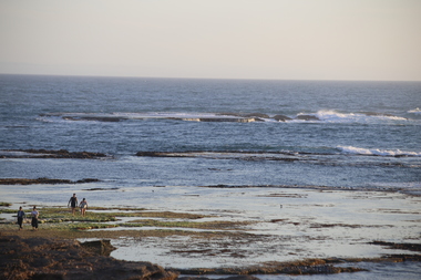
Photograph - Colour, Marema Dogs on Middle Island, Warrnambool, 2019, 27/12/2019
... Warrnambool, Thunder Point, Victoria, Australia ...Colour photos of low tide around Thunder Point, Warrnambool.warrnambool, thunder point, low tide, rocky coast -
 Ballarat Heritage Services
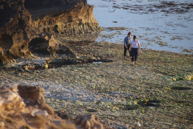
Photograph - Colour, Low Tide around Thunder Point, Warrnambool, 2019, 27/12/2019
... Warrnambool, Thunder Point, Victoria, Australia ...Colour photos of low tide around Thunder Point, Warrnambool.warrnambool, thunder point, low tide, rocky coast -
 Ballarat Heritage Services
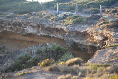
Photograph - Colour, Undercute Coastline around Thunder Point, Warrnambool, 2019, 27/12/2019
... Warrnambool, Thunder Point, Victoria, Australia ...Colour photos of undercut coastline around Thunder Point, Warrnambool.warrnambool, thunder point, low tide, rocky coast -
 Ballarat Heritage Services
Photograph - Colour, Low Tide around Thunder Point, Warrnambool, 2019, 27/12/2019
... Warrnambool, Thunder Point, Victoria, Australia ...Colour photos of low tide around Thunder Point, Warrnambool.warrnambool, thunder point, low tide, rocky coast -
 National Wool Museum
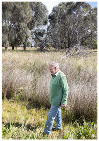
Photograph - Portrait of John Fyfe, Nicole Marie, 2021
... Edwards Point, Victoria ...Thousands of volunteers work tirelessly to conserve and protect the environment of Geelong and the Bellarine. Their work often goes unnoticed. In 'The Work of Nature' the National Wool Museum and the Environment Department at the City of Greater Geelong worked with photographer Nicole Marie to showcase the significant contribution of environment volunteers in our region. Each of the eight people showcased in these portraits were nominated by their peers and members of the community for their significant contribution to conserving and protecting the environment. John Fyfe - Friends of Edwards Point, the Bellarine Catchment Network and many more For over twenty years John Fyfe has been actively involved in all areas of restoring native vegetation on numerous locations throughout the Bellarine. John’s passion for caring for the environment and sharing his vast knowledge has earnt him wide respect from the community. John is not only approachable but a great communicator. His vast knowledge has made the go to person for help on support on all matters regarding revegetation. John introduced direct seeding to the Friends of Edwards Point team, which has been successful on numerous sites within Edwards Points Reserve. The approach has been adopted throughout the reserve. Reflecting on John’s impact to the local community, local residents widely refer to him as a “living legend,” while others simply say, “there should be more John Fyfe’s in the world.” Photo at Edwards Point Wildlife Reserve by Nicole Marie.Image showing an environmental portrait of a man standing in grasslands with trees in the background.environment, conservation, portraits, geelong, nature, exhibition, work of nature, geelong nature forum, volunteers, edwards point -
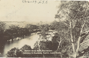 Lakes Entrance Historical Society
Postcard - Snowy River showing Backbone Point, H D Bulmer, Orbost Victoria, 1905 c
... point Orbost Victoria... postcard of Snowy River showing Backbone point Orbost Victoria ...Black and white postcard of Snowy River showing Backbone point Orbost VictoriaSnowy River from Backbonerivers, topography -
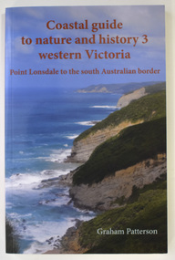 Warrnambool and District Historical Society Inc.
Book - Coastal Western Victoria, Graham Patterson, Coastal Guide to Nature and History 3 Western Victoria, 2022
... on the coastline in Victoria from Point Lonsdale to the South Australian... by Graham Patterson contains details on the coastline in Victoria ...Description of Western Victorian Coast from Point Lonsdale to South Australian BorderThis is a book of 188 pages. The cover has colour photographs and printing in red and white. The pages contain printed text, maps and illustrations, and black and white and colour photographsnon-fictionDescription of Western Victorian Coast from Point Lonsdale to South Australian Borderwestern victoria coastline, graham patterson, warrnambool, shipwreck coast -
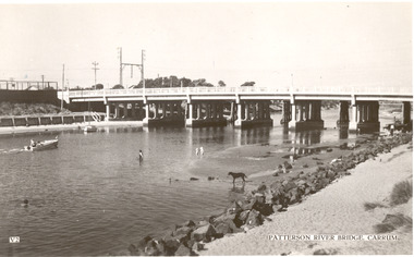 Chelsea & District Historical Society Inc
Photograph - Patterson River, Rail and Road Bridge, Carrum
... Point, Carrum Victoria. ... Beauty Point, Carrum Victoria. Rail and Road Bridge, Carrum ...The first bridge over the river was built in the early 1880's, prior to this it was a pontoon bridge. In 1927 a concrete bridge was built to replace the wooden bridge.Black and white photo of Patterson River, taken from Beauty Point, Carrum Victoria. patterson river, chelsea, patterson river bridge, carrum bridge, beach, leisure, beauty point, boats -
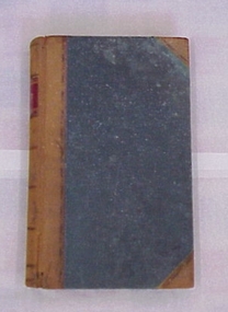 National Wool Museum
Book
... Cumming, Mount Fyans, and Thomas F Cumming, Stony Point, Victoria.... of William Cumming, Mount Fyans, and Thomas F Cumming, Stony Point ...Ledger from the Mount Fyans station, property of William Cumming, Mount Fyans, and Thomas F Cumming, Stony Point, Victoria.LEDGERshearing sheep stations - management, cumming, mr w. b., mount fyans stud, victoria, shearing, sheep stations - management -
Glenelg Shire Council Cultural Collection
Negative - Negative - View of cliffs and beaches Portland Victoria, Zilah Maschmedt, c. 1934
... of cliffs and beaches further past Battery Point Portland Victoria... past Battery Point Portland Victoria Negative Negative - View ...Negative for a black and white photograph showing a view of cliffs and beaches further past Battery Point Portland Victoria -
Moorabbin Air Museum
Book (Item) - CAC Wirraway A20-78 Engine Log Book, Aero - Engine Log Book, WASP H, Mark No. S3-H1-G Maker's No. 14923, 26/09/1944
... at RAAF Point Cook, Victoria.... Squadron at RAAF Point Cook, Victoria. Large blue hardcover book ...Maintenance conducted mostly by the Maintenance Squadron at RAAF Point Cook, Victoria. -
 Lakes Entrance Historical Society
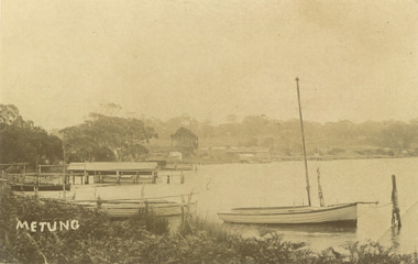
Photograph, Bancroft Bay Metung Victoria, 1900 c
... Point Metung Victoria... beyond taken from Shaving Point Metung Victoria Bancroft Bay ...Sepia toned photograph taken around Bancroft Bay shoreline showing jetties, boatshed, timbered hill beyond taken from Shaving Point Metung Victoriawaterways, topography -
 Wodonga & District Historical Society Inc
Album - Ringer's River by Des Martin - Plate 21 - Swimming cattle across to Victoria
... such successful operations the cattle are swum across to Victoria... operations the cattle are swum across to Victoria at the point where ...But O'Day, the general, has chosen this particular time to ride up river and meet a mob of cattle that Charlie Clowes is bringing down for him from Camoola. In the first of many such successful operations the cattle are swum across to Victoria at the point where O'Day's run, Brightons, comes down to the river.The album and images are significant because they document literature written by a prominent member of the Wodonga community. The presentation of this precis was supported by several significant district families and individuals.Ringer's River Album Coloured photo Plate 21des martin, many a mile, ringer's river, northeast victoria stories -
 Lakes Entrance Historical Society
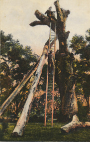
Postcard - Lookout Tree 1890, W T Potter, 1890 c
... from Jemmys Point Kalimna Victoria... from Jemmys Point Kalimna Victoria Postcard Lookout Tree 1890 W ...Black and white postcard of the tall trunk of a dead grey box tree supported by two heavy timber trusses, a long wooden ladder for access to the top area for viewing the lakes and ocean from Jemmys Point Kalimna VictoriaLookout tree Lakes Entrance Cunninghame Victorianavigation -
 Lakes Entrance Historical Society
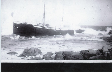
Photograph - SS Saros, 1938
... , funnel missing. Point Hicks Victoria... direction, funnel missing. Point Hicks Victoria Photograph SS Saros ...Boat grounded 23 December 1937Black and white print SS Saros which grounded at Cape Everard aka Point Hicks, abandoned and wrecked. This image shows vessel close to rocky shore, facing generally east direction, funnel missing. Point Hicks Victoriafishing industry, ocean, ships and shipping, shipwrecks -
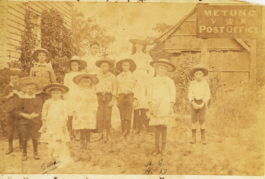 Lakes Entrance Historical Society
Photograph - Grant family, 1895 c
... Grants home on Shaving Point Metung Victoria... and Post Office situated at George Grants home on Shaving Point ...The Village School written by Wendy Male for further informationSepia toned photograph of group of eleven school children and one teacher named are Ethel and Alice Grant and George Ferrera in front of Metungs first school and Post Office situated at George Grants home on Shaving Point Metung Victoriagenealogy, schools -
 Bendigo Historical Society Inc.
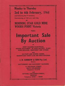
Document - IAN DYETT COLLECTION: AUCTION CATALOGUE - MORNING STAR GOLD MINE
... at the Morning Star Gold Mine at Woods Point, Victoria. Some... at the Morning Star Gold Mine at Woods Point, Victoria. Some descriptions ...Three red covered auction catalogues for a sale of electrical mining machinery, 20 head battery, plant, mine building, equipment and stores held on 3rd to 6th February, 1964 at the Morning Star Gold Mine at Woods Point, Victoria. Some descriptions of electrical equipment, plant and buildings. Auctioneers were J. H. Curnow & Son Pty. Ltd.business, auctioneers, j h curnow & son pty ltd, ian dyett collection - auction catalogue - morning star gold mine, j h curnow & son, lane printing pty ltd -
 Ringwood and District Historical Society
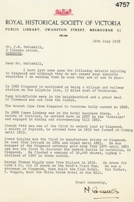
Letter, Letter from M. Greaves of the Royal Historical Society of Victoria to Mr J.K. McCaskill outlining a small number of aspects of early settlement of Ringwood, 16-Jul-58
... of Victoria to Mr J.K. McCaskill outlining a small number of aspects... discovery in Victoria / Antimony / Wood's Point Run / White Horse ...Letter from M. Greaves of the Royal Historical Society of Victoria to Mr J.K. McCaskill outlining a small number of aspects of early settlement of Ringwood. +Additional Keywords: Lindsay, James / Pett, Joseph / Quigley, James / Wiggin, George Thomas / Cobb & Co / Railway / Lilydale / Kaolin discovery in Victoria / Antimony / Wood's Point Run / White Horse Hotel at Box Hill