Showing 37 items
matching victoria. county court
-
 Ringwood and District Historical Society
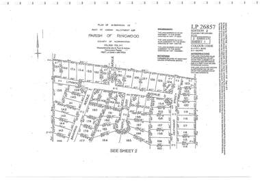
Document - Subdivision Plan, Part of Crown Allotment 32B Parish of Ringwood, County of Mornington Vol 6051 Fol 111 - LP26857
LANDATA Land Victoria 2-sheet plan printout dated 9/11/1953.Sheet 1 includes Lynwood Avenue, Isabel Avenue, Braewood Avenue, Maple Court, and Heathwood Street, Ringwood East, Vic. Sheet 2 includes Braewood Avenue, Rotherwood Avenue, and Heathwood Street, Ringwood East, Vic. Additional markings include LP46598, CP173330, LP86847, LP213448, LP217511, LP207217, LP56241. -
 Ringwood and District Historical Society
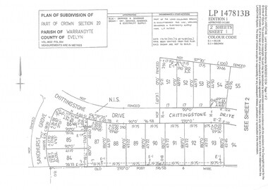
Document - Subdivision Plan, Part of Crown Section 20 Parish of Warrandyte, County of Evelyn Vol 9622 Fol 554 - LP147813B
LANDATA Land Victoria 2-sheet plan printout dated 3/12/1985.Sheet 1 includes Sandhurst Grove and Chittingstone Drive (later Braden Brae Drive) Warranwood, Vic. Sheet 2 includes Standen Court and Chittingstone Drive (later Braden Brae Drive) Warranwood, Vic. -
 Ringwood and District Historical Society
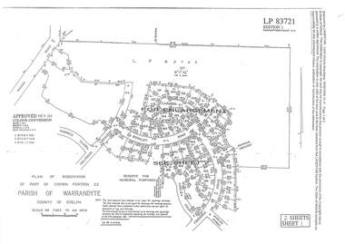
Document - Subdivision Plan, LP83721 Part of Crown Portion 23, Parish of Warrandyte, County of Evelyn, Vol 8708 Fol 351, Vol 8745 Fol 148 and Vol 8751 Fol 034 - 1969
Double sided LANDATA Land Victoria 2-sheet plan printout dated 2009Sheet 1 map and Sheet 2 enlargement including Wonga Road, Holyrood Crescent, Harwick Close, Berkley Road, Frederic Drive, Kenwood Crescent, Adele Court and Marilyn Street, Ringwood. Markings also include LP83722 . -
 Ringwood and District Historical Society
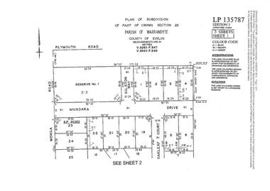
Document - Subdivision Plan, LP135787 Part of Crown Section 23, Parish of Warrandyte, County of Evelyn, Vol 9293 Fol 947 and Vol 9503 Fol 640 - 1984
LANDATA Land Victoria 3-sheet plan printout dated 2007Sheet 1 includes Wonga Road, Mundara Drive, Gilston Way and Oakleaf Court, Ringwood. Additional markings include SP25252. Sheet 2 includes Wonga Road and Oakleaf Court, Ringwood. Sheet 3 includes Wonga Road, Wyndarra Court and Gem Close, Ringwood. -
 Ringwood and District Historical Society
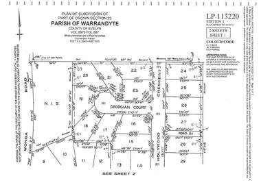
Document - Subdivision Plan, LP113220 Part of Crown Section 23, Parish of Warrandyte, County of Evelyn Vol 8970 Fol 687 - 1975
LANDATA Land Victoria 2-sheet plan printout dated 2009Sheet 1 includes Wonga Road, Holyrood Crescent and Georgian Court, Ringwood. Sheet 2 includes Wonga Road, Holyrood Crescent and Stonington Place, Ringwood. -
 Ringwood and District Historical Society
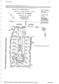
Document - Subdivision Plan, LP76792 Part of Crown Portions 19 & 20A, Parish of Ringwood, County of Bourke, Vol 8382 Fol 140 - 1967
LANDATA Land Victoria plan printout dated 2010Map includes Rupert Street and Prospect Court, Ringwood. -
 Ringwood and District Historical Society
Document - Map, Part of Crown Allotment 27C, Parish of Warrandyte, County of Evelyn, Ringwood, Victoria - c.1970
Photocopy of subdivision plan 75131 Vol 3439 Fol 712 showing numbered residential allotments with property dimensions.Surveyors and Consulting Engineers - O'Connor & Beveridge, Main Eltham Road, Lower Plenty, Tel. 432668. Rubber-stamped "Photocopy - Titles Office Complied 17 Feb 1970". Map includes Lockhart Road, Lansell Close, Terrara Place, Goldsmith Avenue, Park Hill Drive, Hilldale Close, and Elm Court, Ringwood, Victoria.