Showing 173 items matching "victoria. lands department"
-
 Federation University Historical Collection
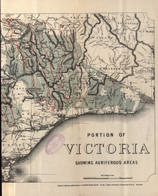
Photograph - coloured, Department of Lands and Survey, Portion of Victoria showing auriferous areas and mineral localities, 1935, 1935
Map included with book "Victoria: Gold and Minerals" issued by Mines Department Victoria, 1935Fold out coloured mapYellow mark indicating depositsvictoria, auriferous areas, mineral localities, department of mines, tin, antimony, copper, silver lead, tungsten, manganese, platinum, iron -
 Federation University Historical Collection
Map - Map and Information, Department of Mines: Map and Suggestions to Prospectors, 1891
The map outlines the auriferous (gold bearing) areas in Victoria. The information for prospectors was prepared by the Department of Mines in 1894Document: 4 page type written Map: Portion of Victoria divided into Counties of 1891. Auriferous areas with red.Reference section on mapgold, auriferous areas, department of mines, victoria, map of victoria, prospectors, commissioner of crown lands, hon a mclean, alexander black, surveyor general, a mclean -
 Ringwood and District Historical Society
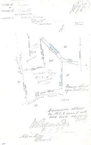
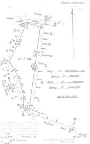
Document - Copy of Lands Department Field Notes - Ringwood, Victoria, Field Notes 76631 Surveyed in 1878
... Copy of Lands Department Field Notes - Ringwood, Victoria... Department Field Notes - Ringwood, Victoria ...Foolscap size photocopy of survey map with handwritten notations. References include Canterbury Road, Bungalook Road, Dandenong Creek, Frank Miller, H.K. Kemps, Leech. Notations signed and dated January 1878 and May 1879. -
 Ringwood and District Historical Society
Document - Copy of Lands Department Field Notes - Ringwood, Victoria, Field Notes 86.87/108 - Survey O.P. R72A dated August 1886 by Surveyor, L. Thorn
... Copy of Lands Department Field Notes - Ringwood, Victoria.... Document Copy of Lands Department Field Notes - Ringwood, Victoria ...Foolscap size photocopies of survey maps with handwritten notations. -
 Ringwood and District Historical Society
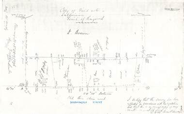
Document - Copy of Lands Department Field Notes - Parish of Ringwood, Victoria, Field Notes 88-9/276 - Part of O.P. R72C surveyed 12.10.1888
Foolscap size photocopy of survey map with handwritten notations. References include - Commencing at bank of creek, Bearing over fence read 134"12', post and rail fence, old round post, Quigley, WB house iron roof, paling & shingle roof, garden, Forshaw formerly Hoare, D Brown, stable & shed, slats & palings, orchard, Occupied by Forshaw, 4 rooms WB Cottage iron roof, Sherbin, Old three chain road, Maroondah Highway, Molloy's corner, I certify that this survey has been effected in accordance with the regulations and that this is a correct copy of my results (signed) - Reed, Assistant Surveyor, 12.10.88. -
 Ringwood and District Historical Society
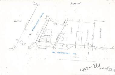
Document - Copy of Lands Department Field Notes - Ringwood, Victoria, Field Notes 1902/261 - Part of O.P. R72D surveyed 14.7.1902
... Copy of Lands Department Field Notes - Ringwood, Victoria... Department Field Notes - Ringwood, Victoria ...Foolscap size photocopies of survey maps with handwritten notations. -
 Ringwood and District Historical Society
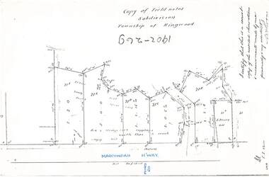
Document - Copy of Lands Department Field Notes - Subdivision Township of Ringwood, Victoria, Field Notes 1902/269 - Part of O.P. R72D surveyed in 1902
Foolscap size photocopy of survey map with handwritten notations. References include Maroondah Highway, (opposite) Mines Road, Ti tree, Sandy soil, heath, spear grass, box & stringy bark sapplings, gentle slope to creek, E. Drury. I certify that this is a correct copy of the recorded observations and measurements made by me personally and my assistant (signed) W. Thorn. -
 Ringwood and District Historical Society
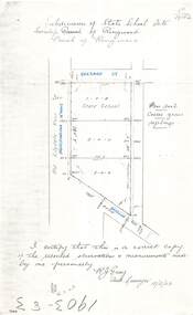
Document - Copy of Lands Department Field Notes - Subdivision of State School Site, Township of Ringwood, Victoria, Field Notes 1903/83 - Part of O.P. R72C Surveyed 13/2/1903
Foolscap size photocopy of survey map with handwritten notations. References include Everard Street, Old Lilydale Road (Maroondah Highway), Dublin Road, poor soil, coarse grass, saplings, I certify that this is a correct copy of the recorded observations & measurements made by me personally (signed) R.J. Gray Autorised Surveyor 13/2/03. -
 Ringwood and District Historical Society
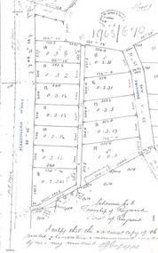
Document - Copy of Lands Department Field Notes - Subdivision of Ringwood, Victoria, Field Notes 1904/188 - Part of O.P. R72D Surveyed 28.4.1904
Foolscap size photocopy of survey map with handwritten notations. References include Mount Dandenong Road to Lilydale, M. Dickson (sold), Church of England, P. Schonnenberger, Helen Lindsay, W.B. iron roof & shingles, I certify that this is a correct copy of the recorded observations and measurement made by me and my assistant (signed) W. Thorn 12/5/04 -
 Ringwood and District Historical Society
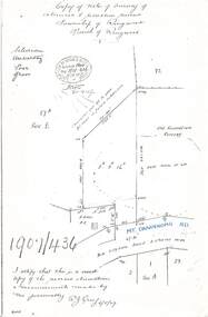
Document - Copy of Lands Department Field Notes - Survey of Extension to Recreation Reserve, Township of Ringwood, Victoria, Field Notes 1907/436 - Part of O.P. R72D Surveyed 6.8.1907
Foolscap size photocopy of survey map with handwritten notations. References include New Lilydale Road 3 chains wide (Mount Dandenong Road), Silurian, undulating, poor grass, Corner cut off to allow for road in future subdivision, Old recreation reserve, (circled area) oval now in use, A. Gisler, I certify that this is a correct copy of the recorded observations & measurements made by me personally (signed) R.J. Gray 6/8/07. -
 Ringwood and District Historical Society
Document - Copy of Lands Department Field Notes - Subdivision Sec E, Township of Ringwood, Victoria, Field Notes 1908/670 - Survey O.P. R72E dated November 1908
Foolscap size photocopies of survey maps with handwritten notations. -
 Ringwood and District Historical Society
Document - Copy of Lands Department Field Notes - Parish of Ringwood, Victoria, Field Notes 1909/174 - Part of O.P. R72D surveyed 12.3.1909
Foolscap size photocopy of survey map with handwritten notations. References include Mount Dandenong Road, pathway, 2 room house, scillion, shed, WC, 17C sold, Cr lands, orchard, 17E sold, Township boundary, I certify that these field notes are a true copy of the actual results of observations and measurements taken by me on the ground (signed) D. Barker 12.3.09. -
 Ringwood and District Historical Society
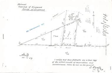
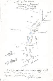
Document - Copy of Lands Department Field Notes - Township of Ringwood, Victoria, Field Notes 1913/163 - Part of O.P. R72D surveyed April 1913
5612b Foolscap size photocopy of survey map with handwritten notations. References include Mines Road, New Lilydale Road (Maroondah Highway), (area) Held for mining, Recreation Reserve, Sec D, Sec E, I certify that this is a correct copy of the recorded observations & measurements made by me personally (signed) R.J. Gray 2/4/13. -
 Ringwood and District Historical Society
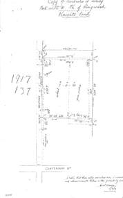
Document - Copy of Lands Department Field Notes - Parish of Ringwood, Victoria, Field Notes 1917/137 - Part of O.P. R72 - Allotment 10, surveyed June 1917
5613b Foolscap size photocopy of survey map with handwritten notations. References include Knight's land, Wantirna Road, Canterbury Road, house, wirenetted, orchard, grass paddock, I certify that these notes are a true copy of observations and measurements taken on the ground by me (signed) H.W. Moore 5/6/17. -
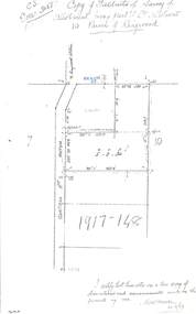 Ringwood and District Historical Society
Document - Copy of Lands Department Field Notes - Parish of Ringwood, Victoria, Field Notes 1917/148 - Part of O.P. R72 - Crown Allotment 10, surveyed June 1917
5614b Foolscap size photocopy of survey map with handwritten notations. References include Wantirna Road, to Ringwood Station, Reilly Street, J. Marshall, fence to be erected on boundary, I certify that these notes are a true copy of observations and measurements made on the ground by me (signed) H.W. Moore 22/6/17. -
 Ringwood and District Historical Society
Document - Copy of Lands Department Field Notes - Parish of Ringwood, Victoria, Field Notes - OP34838 - surveyed in 1919 by D. Barker
5615b Foolscap size photocopy of survey map with handwritten notations. References include Braeside Avenue, Mount Dandenong Road, Rosedale Court, Railway Avenue, cyclone fence, Sec A, WB house, old tennis court netted, stable, old shed, tank stand, orchard, Township Boundary, netting fence, Railway fence, Ringwood to Lilydale Railway, I certify that these fieldnotes are a true copy of the actual results of observations & measurements taken by me on the ground (signed) D. Barker (1919). -
 Ringwood and District Historical Society
Document - Copy of Lands Department Field Notes - Parish of Ringwood, Victoria, Field Notes - 1928/453 - Part of OP R72C Surveyed on 17.11.1928
5616b Foolscap size photocopy of survey map with handwritten notations. References include Whitehorse Road, Mines Road, Wilson Street, Rupert Street, New Road (Braeside Avenue), Section E, Allot 31 sold, Allot 32 sold, Recreation Reserve, Allot 25 sold, Allot 29 sold, hedge, spikes, links on line from each corner, I hereby certify that these field notes were prepared from actual observations and measurements made by me or under my supervision on the ground and in accord with regulations (signed) Authorised Surveyor 17/11/28. -
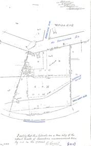
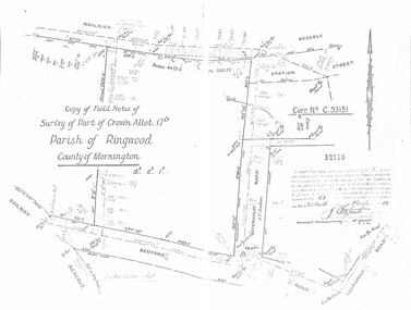 Ringwood and District Historical Society
Document - Copy of Lands Department Field Notes - Parish of Ringwood, Victoria, Field Notes - Part of Crown Allotment 17D Surveyed 1952 (Amended in 1953)
5616b Double foolscap size photocopy of survey map with handwritten notations. References include Corr no. C.93151, Railway Reserve, Station Street, Bedford Road, multiple post & wire fences, multiple galv iron pipes put in, Government Road (Hill Street), Tooronga Road, multiple recent pegs found, Certification 52710 by J. Fitzgerald Licensed Surveyor 17/3/1952. -
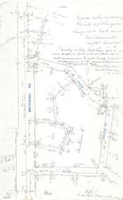
 Ringwood and District Historical Society
Document - Copy of Lands Department Field Notes - Parish of Ringwood, Victoria, Field Notes 55114 Survey of Allotment by J.D. Sherwood in 1955
5618b Foolscap size photocopy of survey map with handwritten notations. References include Railway (Reserve), Education Department, A-B Datum 117degrees20', Bedford Road, Certification by J.D. Sherwood Licensed Surveyor 23/11/1955. -
 Bendigo Historical Society Inc.
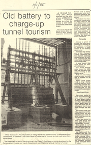
Document - LONG GULLY HISTORY GROUP COLLECTION:OLD BATTERY TO CHARGE-UP TUNNEL TOURISM
Photocopy of a newspaper article titled Old battery to charge-up tunnel tourism. There is a photo of a Thompson's Foundry battery which is being re-erected at the site of the North British mine on Parkin's Reef, near Carman's tunnel. The battery was recovered from a deep gully at Bola Creek. Other works include restoration of quartz roasting kilns and cyanide vats. Written at the top of the article is a date 11/1/85.bendigo, history, long gully history group, the long gully history group - old battery to charge-up tunnel tourism, thompson's foundry, parkin's reef reserve, conservation forests and lands department, carman's tunnel, north british mine, carman's tunnel committee, dr doug kemsley, the prospectors' and miners' association of victoria, mr ken garden -
 Bendigo Historical Society Inc.
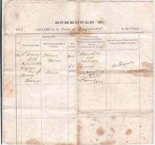
Document - DEATH CERTIFICATE OF THOMAS MORAN
Certified copy of the registration of the death and burial Thomas Moran, miner. District of Raywood, Colony of Victoria. Date of copy 19 February 1885. Signed by H.R.Hyde, Deputy Registrar, Raywood. On the rear: Noted in Lands Department, Chas A Roberts, 25/2/1885. Death of Thomas Moran - 6 February 1882 at Inglewood Hill, Raywood Borough, County of Bendigo. Male aged 61 years. Cause of death: bronchitis and asthma. Duration of last illness: 2 years. Medical attendant by whom certified: P.H. McGillivray M.R.C.S. Sandhurst. Last saw the deceased: 26 November 1881. Parents unknown. Informant: William English, son-in-law, Raywood . Deputy Registrar: H.R.Hyde. Date of registration: 7 February 1882. Buried Raywood Cemetery 7 February 1882. Undertaker: William English, Raywood. Minister/Witnesses: Dennis Fogarty, Daniel Ryan. Where born: Kilkenny Ireland, One year in NSW, 30 years in Victoria. Married Melbourne, age 34, to Mary Dundon. Issue: Mary 26 years and Catherine 25 yearsgenealogy, family, moran, thomas moran, raywood, inglewood hill, william english, h.r.hyde, p.h mcgillibray, daniel ryan, death certificate, raywood cemetery, denis fogarty, kilkenny ireland -
 Bendigo Historical Society Inc.
Map - NOLAN : COUNTY OF BENDIGO, 7-5-30
Map. Nolan, County of Bendigo, Egerton, Elmore, Goornong, Campaspe River, Northern Railway. By Authority H.J. Green, Government Printer, Melbourne. Drawn and reproduced at the Department of Lands and Survey, Melbourne, Victoria.7-5-30. Price 2/-. (number 78 in map cupboard 1)H.J. Green, Government Printer, Melbourne.map, bendigo, nolan -
Bendigo Historical Society Inc.
Map - NERRING : COUNTY OF BENDIGO, August 1952
Map. Nerring, County of Bendigo, Yarraberb, Leichardt, Marong, Sandhurst, Huntly, Neilborough, Bendigo and Swan Hill Railway, Bendigo and Kulwin Railway, Loddon Valley Highway. By authority J.J. Gourley, Government Printer, Melbourne. Drawn and reproduced at the Department of Lands and Survey, Melbourne, Victoria. August 1952. Price $1.00. (number 76 in map cupboard 1)J.J. Gourley, Government Printer, Melbourne.map, bendigo, nerring -
Bendigo Historical Society Inc.
Map - MARONG : COUNTY OF BENDIGO, June 1953
Map. Marong, County of Bendigo, Nerring, Sandhurst, Lockwood, Shelbourne, Woodstock, Leichardt, Fletcher Creek, Bullock Creek, Township of Marong, Marong Railway Station, Bendigo Railway Line, Spring Creek, Crusoe Aqueduct. By authority W.M. Houston, Government Printer. Drawn and reproduced at the Department of Lands and Survey, Melbourne, Victoria. June 1953. Price 2/-. (number 73 in map cupboard 1)W.M. Houston, Government Printermap, bendigo, marong -
Bendigo Historical Society Inc.
Map - CAMPBELL COLLECTION: BENDIGO AND DISTRICT MAPS, June 1953
Map. Marong, County of Bendigo, Scale 40 chains to 1 inch. Woodstock, Leichardt, Nerring, Sandhurst, Lockwood, Shelbourne. Drawn and reproduced at the Department of Lands and Survey, Melbourne, Victoria. By Authority : W.M. Houston, Government Printer. June 1953. Price 2/-. (number 403 in map cupboard 1)W.M. Houston, Government Printer.map, bendigo, agricultural lands -
Bendigo Historical Society Inc.
Map - CAMPBELL COLLECTION: BENDIGO AND DISTRICT MAPS, August 1952
Map. Nerring, County of Bendigo, Yarraberb, Neilborough, Leichardt, Marong, Sandhurst, Huntly. Scale 20 chains to 1 inch. Drawn and reproduced at the Department of Lands and Survey, Melbourne, Victoria, August 1952. Price 2/-. By Authority J.J. Gourley, Government Printer, Melbourne. (number 404 in map cupboard 1)J.J. Gourley, Government Printermap, bendigo, allotments -
Bendigo Historical Society Inc.
Map - CAMPBELL COLLECTION: BENDIGO AND DISTRICT MAPS, 11-2-37
Map. Parish of Shelbourne, County of Bendigo. Scale 40 chains to 1 inch. Drawn and reproduced at the Department of Lands and Survey, Melbourne, Victoria. Price 2/-.11-2-37. By Authority H.J. Green, Government Printer, Melbourne.H.J. Green, Government Printermap, bendigo, agricultural lands -
Bendigo Historical Society Inc.
Map - BENDIGO, 1916
Map. Bendigo, Gunbower, Gladstone, Talbot, Dalhousie, Rodney, Jarklan, Calivil, Hayanmi, Mitiamo, Wanurp, Pannoobamawm, Bamawm, Millewa, Ballendella, Janiember West, Janiember East, Pompapiel, Talambe, Dingee, Milloo, Pannoomilloo, Rochester West, Yarrayne, Salisbury, Yallook, Tandarra, Kamarooka, Warragamba, Diggorra, Minto, Bridgewater, Yarraberb, Neilborough, Whirrakee, Egerton, Elmore, Nolan, Goornong, Bagshot, Huntly, Derby, Leichardt, Nerring, Tarnagulla, Woodstock, Marong, Sandhurst, Wellsford, Bendigo, Axedale, Strathfieldsaye, Eppalock, Kimbolton, Lyell, Sedgwick, Mandurang, Lockwood, Ravenswood, Shelbourne, Laanecoorie. Price 3/-. Smaller map of State of Victoria. Lithographed at the Department of Lands and Survey, Melbourne. 1916. Scale : Two miles to one inch. Map was in book form. (number 62 in map cupboard 1)map, bendigo, bendigo -
Bendigo Historical Society Inc.
Map - BAGSHOT : COUNTY OF BENDIGO, November 1948
Map. Bagshot. County of Bendigo, Huntly, Whirrakee, Egerton, Goornong, Ellesmere, Wellsford. Reedy Creek, Sandy Creek. Drawn and reproduced at the Department of Lands and Survey, Melbourne, Victoria. November 1948, Price 2/-. By authority J.J. Gourley, Government Printer, Melbourne. (number 46 in map cupboard 1)J.J. Gourley, Government Printer, Melbourne.map, bendigo, bagshot -
Bendigo Historical Society Inc.
Map - JANIEMBER EAST : COUNTY OF BENDIGO, 15-1-34
Map. Janiember East, County of Bendigo, Jarklan, Pompapiel, Yarrayne, Powlet, Janiember West, Serpentine Creek, Caney's Blind Creek Long Plain Creek, Loddon River. By authority : H.J. Green, Govt. Printer, Melbourne. Drawn and reproduced at the Department of Lands and Survey, Melbourne, Victoria. Price 2/-. 15-1-34. (number 45 in map cupboard 1)H.J. Green, Govt. Printer, Melbourne.map, bendigo, janiember east