Showing 129 items
matching viewing platform
-
 Eltham District Historical Society Inc
Film - Video (VHS), Nillumbik Shire Council, The Nillumbik Story, 1996
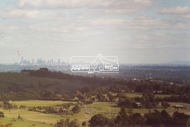
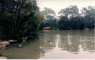
... Viewing platform... program and the newly constructed (1996) viewing platform built... program and the newly constructed (1996) viewing platform built ...PART 1 – NILLUMBIK (00:00-07:17) Opening features various scenes around Nillumbik Shire. For 40,000 years Nillumbik was the home of the Wurundjeri people. Robert Hoddle gave the district its name. Jock Ryan, then president of Nillumbik Historical Society discusses the names Nillumbik and Diamond Creek. In the late 1830s white occupation began with gold found in Warrandyte in 1851 and 12 years later at Diamond Creek -the Diamond Reef which led to the Caledonian gold rush. Jock Ryan discusses the Diamond Creek mine, which was thriving until it burnt out in 1915. Large numbers of workmen moved into area in late 1870s to construct the Maroondah Aqueduct. With growing population of Melbourne, the nearby Yan Yean system had severely disrupted the flow of the Plenty River, forcing the closure of three flour mills there. The aqueduct came to the rescue carrying water 66km from Healesville to Preston. When the Diamond Creek gold mine burnt down the local economy suffered but fruit growing industry had already been established and Diamond Creek became a thriving fruit growing centre. Interview with Jack Powell, a long-time fruiterer at St Andrews market, his family had lived in the area for a hundred years, 3 to 4 generations, “a lot of hard work”. By the time the railway arrived fruit growing was no longer competitive. The railway brought the city closer and day trippers. The Green Wedge separates the shire from the more densely developed neighbours such as Whittlesea, Doncaster, Templestowe, Bulleen and Greensborough. Population at the time (1996) was 19,000 but links to the past remain strong. Mudbrick houses along the Heritage Trail The saving of Shillinglaw Cottage from demolition in 1963 and relocation brick by brick. PART 2 – ENVIRONMENT (07:18-14:44) Peter Brock (with Bev Brock in background) at St Andrews market discusses his childhood growing up in the district and the environment and the values it instilled upon him and his own family. The Brocks have been in the district since the 1860s. Nillumbik Shire responsible for managing three catchment areas; Diamond Creek, Arthurs Creek and Watsons Creek. Follows the course of the Diamond Creek commencing in Kinglake through the district to its confluence with the Yarra River at Eltham at Eltham Lower Park. Highlights Eltham Lower Park community revegetation program and the newly constructed (1996) viewing platform built of new and recycled timbers at the confluence of the Diamond Creek and Yarra River. Also featured are outdoor recreation on the river and at Eltham Lower Park including the Diamond Valley miniature railway. Sugarloaf reservoir and recreational activities and fishing. Aerial view of Memorial Park and Shire of Eltham War Memorial tower at Garden Hill, Kangaroo Ground. Significant tourism opportunities for the shire with 3 million potential day-trippers in metropolitan Melbourne. Council and community working together to find a way to promote the shires natural and artistic assets. At Arthurs Creek, the Brock family and neighbours working together to take care of their waterway. Peter Brock’s uncle, Sandy Brock talks about environmental management and the Arthurs Creek Landcare group and actions to eradicate blackberry problem. Having previously planted Cypress rows they are replacing them with indigenous species to improve the water supply, keeping cattle out of the creek bed to improve the quality downstream flowing into the Yarra. Eltham East Primary School Band playing “All things bright and beautiful” merges into scenes of the bushland sanctuary set aside by the school in 1980 with unidentified teacher discusses the sanctuary and their education program and school children’s comments. Plight of a family of Wedgetail eagles nesting in the path of a developer’s bulldozer at North Warrandyte and actions to save their nesting areas. PART 3 – ARTS (14:45-22:00) Arts and Jazz festival at Montsalvat featuring interviews with Sigmund Jorgensen discussing Montsalvat and its principles. Also Matcham Skipper. Clifton Pugh’s funeral at Montsalvat and his legacy at Dunmoochin near Cottlesbridge with artists in residence, at the time, Chicago artist Charles Reddington who discusses the benefits of the experience. An unidentified female artist also talks about the program and why people are drawn to the area. Unidentified man on street talking about the amount of talent in the area, artists, poets, musicians, authors. Artist Ming Mackay (1918-2009) interviewed talking about the people she mixes with on “the Hill”. Works of local artists are displayed Eltham Library Community Gallery and Wiregrass gallery with a new coffee shop at the Wiregrass making it an even more popular destination. Music at St Andrews Hotel (may be a little bit country) and the Saturday market where likely to hear anything. Sellers and patrons at the market asked about what attracts them to the market and where they came from. Scenes of poets/authors giving readings. CREDITS Music by John Greenfield from the CD Sweet Rain “The Snow Tree”, Uncle Music UNC 2001 Cameras - David Mirabella and Peter Farragher Editor – Olwyn Jones Written and Produced by Jason Cameron A Jason Cameron Proction for Nillumbik ShireProvides a record of the relatively newly created Shire of Nillumbik at the time and the features and attactions of the shire in its people arts, culture and environmentVHS Cassette (five copies) DVD (one copy) Converted to MP4 file format 0:22:00, 1.60GBvideo recording, arthurs creek, arthurs creek landcare group, artists, artists in residence, arts, arts festival, authors, blackberry, brock family, bulldozer, bulleen, bushland sanctuary, caledonian gold rush, charles reddington, clifton pugh, cottlesbridge, cypress rows, developer, diamond creek, diamond creek mine, diamond reef, diamond valley miniature railway, doncaster, dunmoochin, education program, eeps, eltham, eltham east primary school, eltham east primary school band, eltham library community gallery, eltham lower park, environment, fishing, flour mill, fruit growing, fruiterer, garden hill, gold mining, green wedge, greensborough, heritage trail, hurstbridge railway line, jazz festival, jock ryan, kangaroo ground, kangaroo ground tower, kinglake, maroondah aqueduct, matcham skipper, memorial park, ming mackay (1918-2009), montsalvat, mudbrick houses, music, musicians, nesting area, nillumbik historical society, nillumbik shire, north warrandyte, old timer, orchards, peter brock, plenty river, poets, population, recreation, recreational activities, revegetation, robert hoddle, sandy brock, shillinglaw cottage, shire of eltham war memorial, sigmund jorgensen, st andrews hotel, st andrews market, sugarloaf reservoir, templestowe, the hill, tourism, viewing platform, warrandyte, water catchment area, watsons creek, wedgetail eagle, whittlesea, wiregrass gallery, wurundjeri, yarra river, jack powell -
 Eltham District Historical Society Inc
Photograph, Shire of Eltham Memorial Park, Garden Hill, Eltham-Yarra Glen Road, Kangaroo Ground, May 2011
... moor-rul viewing platform... memorial park war memorial tower garden hill moor-rul viewing ...Colour photo print 15 x 10 cm (2 of 6)eltham-yarra glen road, kangaroo ground, shire of eltham memorial park, war memorial tower, garden hill, moor-rul viewing platform -
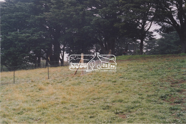
 Eltham District Historical Society Inc
Photograph, Shire of Eltham Memorial Park, Garden Hill, Eltham-Yarra Glen Road, Kangaroo Ground, c.2008
... moor-rul viewing platform... memorial park war memorial tower garden hill moor-rul viewing ...Colour photo print 15 x 10 cm (1 of 4)eltham-yarra glen road, kangaroo ground, shire of eltham memorial park, war memorial tower, garden hill, moor-rul viewing platform -
 Eltham District Historical Society Inc
Photograph, Shire of Eltham Memorial Park, Garden Hill, Eltham-Yarra Glen Road, Kangaroo Ground, c.2008
... moor-rul viewing platform... memorial park war memorial tower garden hill moor-rul viewing ...Colour photo print 15 x 10 cm (2 of 4)eltham-yarra glen road, kangaroo ground, shire of eltham memorial park, war memorial tower, garden hill, moor-rul viewing platform -
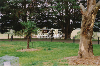
 Eltham District Historical Society Inc
Photograph, Shire of Eltham War Memorial, Garden Hill, Eltham-Yarra Glen Road, Kangaroo Ground, c.2008
... moor-rul viewing platform... memorial park war memorial tower garden hill moor-rul viewing ...Colour photo print 15 x 10 cm (2 of 4)eltham-yarra glen road, kangaroo ground, shire of eltham memorial park, war memorial tower, garden hill, moor-rul viewing platform -
 Whitehorse Historical Society Inc.
Photograph, Blackburne Lake Reserve
... a viewing platform.... photograph of a part of the lake showing a viewing platform ...A coloured photograph of a part of the lake showing a viewing platform.blackburn lake reserve, blackburn lake -
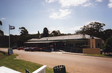
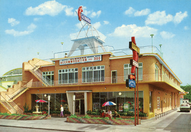 Lakes Entrance Historical Society
Photograph - Glenara Motel, Engelander, John, & Co Pty Ltd, 1950c
... Motel, viewing platform accessed by external stairway, low fence... Motel, viewing platform accessed by external stairway, low fence ...Colour photograph of double storey brick building, Glenara Motel, viewing platform accessed by external stairway, low fence of variegated brick on Esplanade. Illuminated sign Glenara above viewing platform. Lakes Entrance Victoriamotels, entertainment, rsl clubs, architecture, fences, rsl clubs -
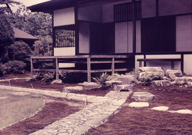 Robin Boyd Foundation
Slide, Robin Boyd, 1964
... Colour slide in a mount. Ko-shoin: Moon-Viewing Platform... in a mount. Ko-shoin: Moon-Viewing Platform, Katsura Imperial Villa ...Robin Boyd wrote two books on Japanese architects and architecture - “Kenzo Tange” published by George Braziller in 1962 and “New Directions in Japanese Architecture” published by Studio Vista in 1968. During the 1960s he travelled several times to Japan to research these books and as part of his role as Exhibits Architect for the Australian Pavilion at Expo ‘70 in Osaka.Colour slide in a mount. Ko-shoin: Moon-Viewing Platform, Katsura Imperial Villa, Kyoto, JapanTokyo, Japan / Japanese Gardens (2) / Katsura Inperial Villa / Step at Ko Shoin and Moon-view pavilion / 8 / Encircled 3 (Handwritten) / Encircled 3 (Handwritten)slide, robin boyd -
 Marysville & District Historical Society
Photograph (item) - Colour photograph, Pre 2009
... with the viewing platform in the foreground.... the viewing platform that was destroyed in the 2009 Black Saturday ...A colour photograph of Steavenson Falls in Marysville in Victoria.A colour photograph of Steavenson Falls in Marysville in Victoria. The photograph shows the viewing platform that was destroyed in the 2009 Black Saturday bushfires. The Steavenson Falls is named after the Victorian Assistant Commissioner of Roads and Bridges, John Steavenson who arrived in Victoria in the early 1860s.steavenson falls, waterfalls, marysville, victoria, john steavenson, 2009 black saturday bushfires -
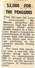 Phillip Island and District Historical Society Inc.
Newspaper Clipping, 31/11/1968
... to help restore damage to the beach and viewing platform... and viewing platform at the Penguin Parade Phillip Island. Newspaper ...Article from a collection of newspaper clippings from October 1968 to July 1971Article about the Victorian Government offer of $2,000 to help restore damage to the beach and viewing platform at the Penguin Parade Phillip Island.phillip island, penguin beach, penguin parade, mr hamer -
 Lakes Entrance Historical Society
Photograph - Lakes Entrance, M Holding, 1/03/2004 12:00:00 AM
... Colour photograph taken from Kalimna viewing platform from... Kalimna viewing platform from Rigby to outer barrier and Bass ...Colour photograph taken from Kalimna viewing platform from Rigby to outer barrier and Bass Strait beyond, East Gippsland Victoriawaterways, lakes entrance -
 Lakes Entrance Historical Society
Photograph - Kalimna Hotel, 1999c
... Colour photograph taken from the viewing platform looking... Restaurant Colour photograph taken from the viewing platform looking ...Part of the original building burnt down May 1962.Colour photograph taken from the viewing platform looking back at Kalimna Hotel. Front veranda now built-in to create dining area. Lakes Entrance Victoria.hotels, restaurant -
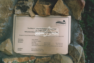
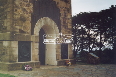
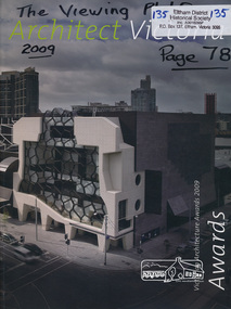 Eltham District Historical Society Inc
Book, Architect Victoria (magazine): Victorian Architecture Awards 2009, 2009
... Page 78 records details of The Shadow of Bunjil viewing... viewing platform kangaroo ground monuments war memorials shadow ...Page 78 records details of The Shadow of Bunjil viewing platform at Kangaroo Groundp78 - Kangaroo Ground War memorial viewing platformvolume : colour illustrations ; 30 cm.kangaroo ground, monuments, war memorials, shadow of bunjil -
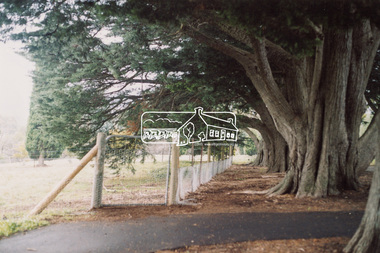
 Eltham District Historical Society Inc
Slide, Shire of Eltham War Memorial Tower, Eltham-Yarra Glen Road, Kangaroo Ground, 24 Jul 1973
... viewing platform and grasslands now stand.... viewing platform and grasslands now stand. kangaroo ground shire ...Looking east towards the tower across the western title of land purchased by Council 16 Feb. 1973 upon which the Moor-rul viewing platform and grasslands now stand.35 mm colour positive transparency Mount - Agfacolor Service (Blue)kangaroo ground, shire of eltham, war memorial tower, eltham-yarra glen road, shire of eltham war memorial -
 Eltham District Historical Society Inc
Slide, Shire of Eltham War Memorial Tower, Eltham-Yarra Glen Road, Kangaroo Ground, 24 Jul 1973
... viewing platform and grasslands now stand.... viewing platform and grasslands now stand. eltham-yarra glen road ...Looking east towards the tower across the western title of land purchased by Council 16 Feb. 1973 upon which the Moor-rul viewing platform and grasslands now stand.35 mm colour positive transparency Mount - Agfacolor Service (Blue)eltham-yarra glen road, kangaroo ground, shire of eltham war memorial, war memorial tower -
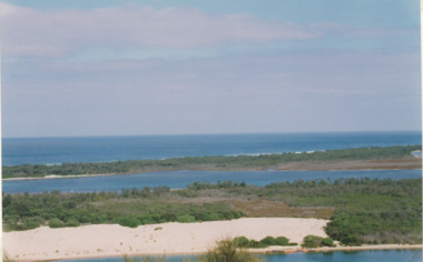
 Lakes Entrance Historical Society
Photograph - Fraser Island, Holding M, 2000c
... . Fence and pathway to viewing platform in centre foreground... of the homestead garden. Fence and pathway to viewing platform in centre ...Colour photograph taken from the veranda of Nyerimilang Homestead, Gippsland Lakes. It shows a glimpse of Fraser Island through the trees and ornamental shrubs of the homestead garden. Fence and pathway to viewing platform in centre foreground. Lakes Entrance Victoriaislands, historic site -
 Glenelg Shire Council Cultural Collection
Photograph - Photograph - Henty Beach, Portland, 19/11/1934
... Saints. Crowd of people on viewing platform on cliff top, horses... Portland, centenary celebrations, 19 NOV. 1934. View from top ...Black and white photo, Henty Beach Portland, centenary celebrations, 19 NOV. 1934. View from top of cliff looking towards All Saints. Crowd of people on viewing platform on cliff top, horses, crowds, cars, flag pole, piers.henty beach, seascape, coastline, beach, 1934, centenary -
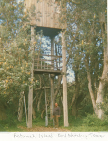 Lakes Entrance Historical Society
Photograph, Vera Bennett, Rotamah Island, Gippsland Lakes Victoria, 1/04/1989 12:00:00 AM
... Island showing a timber hut and viewing platform supported... and viewing platform supported on four timber poles accessed by steel ...Colour photograph of the bird watching tower on Rotamah Island showing a timber hut and viewing platform supported on four timber poles accessed by steel ladders. Tower situated amongst coastal banksias Gippsland Lakes Victoria. Also another colour photograph of bird watching towerpeople, wildlife, topography, waterways -
 Lakes Entrance Historical Society
Photograph - The Lakes Entrance Hotel/Thomas Laughton, 1889
... Entrance Hotel. It shows a stylised view of a large weatherboard... with verandah across the main entrance with a viewing platform above ...Lakes Entrance Hotel erected 1878 by Thomas Laughton Also second sketch of front of the hotel with 6 people on upper balcony Black and white photograph of a drawing of the Lakes Entrance Hotel. It shows a stylised view of a large weatherboard building with verandah across the main entrance with a viewing platform above. Horse drawn vehicle beside hotel, signal flagpole at front, a schooner and steamer in distant waterway. Lakes Entrance Victoria. Second sketch of front of hotelThe Lakes Entrance Hotel (immediately opposite the Southern Ocean Cunninghame) Edwin Stephenson Proprietor(under the patronage of the Governor Sir H B Lock K C B). buildings, hotels, genealogy -
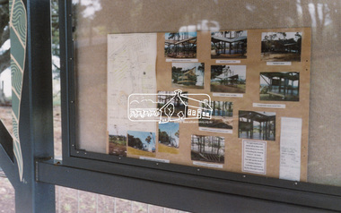
 Eltham District Historical Society Inc
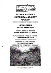
Newsletter, Newsletter, No. 179 March 2008
... of the Viewing Platform at Kangaroo Ground • Centenary of Women’s... of the Viewing Platform at Kangaroo Ground • Centenary of Women’s ...Contents: • Next meeting, guest speaker; Harold Bird AOM: An Illustrated Talk on AOS6 and the Bird Family Orchard • Annual General Meeting • AOS6 and the Bird Family Orchard • Opening of the Viewing Platform at Kangaroo Ground • Centenary of Women’s Suffrage in Victoria • Eltham’s Homeless by Sue Law • Shillinglaw Family History • More Coming Events The Shire of Eltham Historical Society was formed in October 1967. The first newsletter of the Society was issued May 1978 and has been published continuously ever since on a bi-monthly basis. With the cessation of the Shire of Eltham in late 1994, the Society's name was revised to Eltham District Historical Society and this name first appeared with issue No. 103, July 1995. The collection of the Society's newsletters provides a valuable resource on the history of the Society's activities, office bearers and committee members, guest speakers and subjects of historical interest pertinent to the former Shire of Eltham and the Eltham District.A4 photocopied newsletter distributed to membersnewsletter, eltham district historical society, shire of eltham historical society -
 Federation University Historical Collection
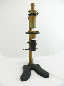
Equipment - Polarised Light Apparatus, Microscope, c1870
... , a mirror to reflect the light, and a viewing platform.... platform with small brass clips holding a glass lens in position ...Used in physics/optics laboratory at Mt Helen, most probably transferred from SMB to Mt Helen c1870 as SMB start date but could be much earlier A vertical arrangement of lenses, mirrors and polarisers mounted on a brass stand 50cm high with a heavy metal claw foot base. Circular calibrated 360 degrees platform with small brass clips holding a glass lens in position. Parts appear to be original, though the object appears to be missing a eye piece, a mirror to reflect the light, and a viewing platform.CS - 77optics, lenses, mirrors, smb, rocks, microscope, polarisers, scientific instruments -
 Lakes Entrance Historical Society
Photograph - Lookout tree, 1900
... branches used as a viewing platform. One person sitting on top, man... branches used as a viewing platform. One person sitting on top, man ...Image appears to be copied from an original postcard, maker unidentified|Also and enlarged copy of photograph 27 x 17Colour photograph of the LookOut Tree on Jemmys Point, shows a dead standing grey box tree supported by two logs and with a ladder over thirty feet long attached for access to the four branches used as a viewing platform. One person sitting on top, man in Indian dress halfway up ladder. Lakes Entrance Victoria.LookOut Tree at Lakes Entrance Cunninghame, Victoriahistoric sites, navigation -
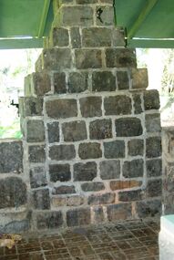
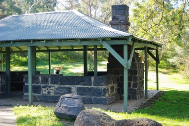
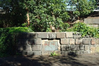
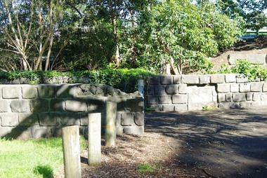
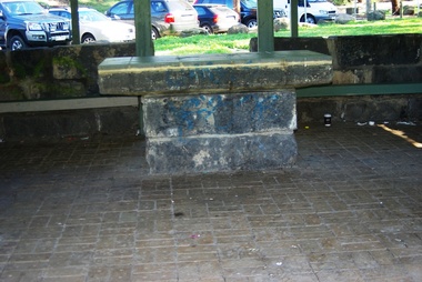 Greensborough Historical Society
Photograph - Digital Image, Pioneer Reserve 2014 -2, 01/10/2014
... . 1864 - 1960s. The shelter, viewing platform, retaining wall... the Plenty River, c. 1864 - 1960s. The shelter, viewing platform ...Pioneer Reserve, Greensborough is a small park on the corner of St Helena and Diamond Creek Roads. It is adjacent to the site of Greensborough's first bridge across the Plenty River, c. 1864 - 1960s. The shelter, viewing platform, retaining wall and entrance are built from the bridge's massive bluestone arched abutments dismantled between 1974 and 1983. Photograph by Marilyn Smith 2014.Digital copy of colour photograph.pioneer reserve greensborough -
 Greensborough Historical Society
Photograph - Digital Image, Pioneer Reserve 2014 -3, 01/10/2014
... . 1864 - 1960s. The shelter, viewing platform, retaining wall... the Plenty River, c. 1864 - 1960s. The shelter, viewing platform ...Pioneer Reserve, Greensborough is a small park on the corner of St Helena and Diamond Creek Roads. It is adjacent to the site of Greensborough's first bridge across the Plenty River, c. 1864 - 1960s. The shelter, viewing platform, retaining wall and entrance are built from the bridge's massive bluestone arched abutments dismantled between 1974 and 1983. Photograph by Marilyn Smith 2014.Digital copy of colour photograph.pioneer reserve greensborough -
 Greensborough Historical Society
Photograph - Digital Image, Pioneer Reserve 2014 -4, 23/09/2014
... . 1864 - 1960s. The shelter, viewing platform, retaining wall... the Plenty River, c. 1864 - 1960s. The shelter, viewing platform ...Pioneer Reserve, Greensborough is a small park on the corner of St Helena and Diamond Creek Roads. It is adjacent to the site of Greensborough's first bridge across the Plenty River, c. 1864 - 1960s. The shelter, viewing platform, retaining wall and entrance are built from the bridge's massive bluestone arched abutments dismantled between 1974 and 1983. Photograph by Marilyn Smith 2014.Digital copy of colour photograph.pioneer reserve greensborough -
 Greensborough Historical Society
Photograph - Digital Image, Pioneer Reserve 2014 -5, 23/09/2014
... . 1864 - 1960s. The shelter, viewing platform, retaining wall... the Plenty River, c. 1864 - 1960s. The shelter, viewing platform ...Pioneer Reserve, Greensborough is a small park on the corner of St Helena and Diamond Creek Roads. It is adjacent to the site of Greensborough's first bridge across the Plenty River, c. 1864 - 1960s. The shelter, viewing platform, retaining wall and entrance are built from the bridge's massive bluestone arched abutments dismantled between 1974 and 1983. Photograph by Marilyn Smith 2014.Digital copy of colour photograph.pioneer reserve greensborough -
 Greensborough Historical Society
Photograph - Digital Image, Pioneer Reserve 2014 -6, 23/09/2014
... . 1864 - 1960s. The shelter, viewing platform, retaining wall... the Plenty River, c. 1864 - 1960s. The shelter, viewing platform ...Pioneer Reserve, Greensborough is a small park on the corner of St Helena and Diamond Creek Roads. It is adjacent to the site of Greensborough's first bridge across the Plenty River, c. 1864 - 1960s. The shelter, viewing platform, retaining wall and entrance are built from the bridge's massive bluestone arched abutments dismantled between 1974 and 1983. Photograph by Marilyn Smith 2014.Digital copy of colour photograph.pioneer reserve greensborough