Showing 379 items
matching water carrying
-
 Bendigo Military Museum
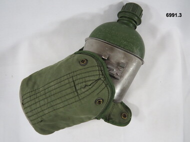
Equipment - WATER BOTTLE, CARRIER, CANTEEN, Department of Defence, 1968
... out handle. 3. Water bottle outer carry cover, green colour.... Water bottle outer carry cover, green colour shaped as for 1 ...1. Water bottle, kidney shape plastic green in colour with an attached screw top lid. 2.Cup canteen, stainless steel with a fold out handle. 3. Water bottle outer carry cover, green colour shaped as for 1. and 2. Water proof outer material, soft inner lining. Two folding flaps with press stud closure, back has webbing section sewn on with web belt and webbing attachments.1. On side, "FOR WATER ONLY DO NOT APPLY CANTEEN TO OPEN FLAME OR BURNER PLATES". On the base, "V1968^ 8465-71-108-8703" 2. "Stokes MELB 8465-50-242-7843 1968^". 3. Under webbing section, "Very faint stencilled lettering".passchendaele barracks trust, canteen, water, outer cover, equipment -
 Warrnambool and District Historical Society Inc.
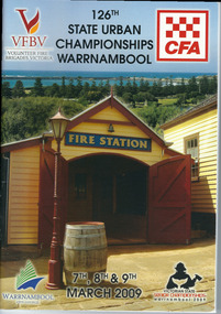
Programme - Booklet, CFA 126 Championship, 2009
... required to carry water to fire scenes. In 1889 the Council built... house was in Liebig Street and carters were required to carry ...The Warrnambool Fire Brigade was formed in 1863. The first fire engine house was in Liebig Street and carters were required to carry water to fire scenes. In 1889 the Council built a new Fire Station on Liebig Street and Warrnambool hosted its own Annual Demonstration in 1894. In 1891 the volunteer brigade became part of the Country Fire Brigade. The Fire Station relocated to Raglan Parade in 1915 and then to Timor Street in 1961. In 1989 the Brigade moved back to Raglan Parade. This booklet is a memento of the State Urban Championships that were held in Warrnambool in 2009 (Volunteer Fire Brigades Victoria and Country Fire Authority)This is a booklet of 96 pages containing printed material, maps, advertisements, photographs and tables. The back cover is white with a Powercor Australia symbol in red and printed material. The front cover is multi-coloured with a photograph of the Fire Station at Flagstaff Hill Maritime Village. The pages are stapled.Front Cover: VFBV, Volunteer Fire Brigades Victoria, CWA, 126th State Urban Championships, 7th, 8th and 9th March 2009, Victorian State Senior Championships, Warrnambool 2009, Warrnambool City Council logowarrnambool fire brigade, state urban championships (2009) -
 Warrnambool and District Historical Society Inc.
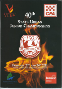
Booklet, CFA 40th Championship, 2003
... required to carry water to fire scenes. In 1889 the Council built... required to carry water to fire scenes. In 1889 the Council built ...The Warrnambool Fire Brigade was formed in 1863. The first fire engine house was in Liebig Street and carters were required to carry water to fire scenes. In 1889 the Council built a new Fire Station on Liebig Street and Warrnambool hosted its own Annual Demonstration in 1894. In 1891 the volunteer brigade became part of the Country Fire Brigade. The Fire Station relocated to Raglan Parade in 1915 and then to Timor Street in 1961. In 1989 the Brigade moved back to Raglan Parade. This booklet is a memento of the State Championships that were held in Warrnambool to mark 150 years of community service to Warrnambool by the Warrnambool Fire Brigade. (2013)This is a booklet of 63 pages containing printed material, maps, advertisements and photographs. The back cover is red and the front cover has a black background with an image of flames and a badge with the title of the booklet. The pages are stapled.Front Cover: VFBV, CFA, 40th State Urban Junior Championships, February 23rd and 24th 2013, Friendly Societies Park, Hyland Street, Warrnambool, Warrnambool City Council, Powercor Australia Back Cover: Powercor Australia warrnambool fire brigade, state urban junior championships -
 Bendigo Military Museum
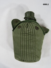
Equipment - WATER BOTTLE, CANTEEN, CARRIER, Department of Defence, 1. 1969. 2.1991
... 1. Water bottle, kidney shaped, plastic green colour... 1991 ^" On underside of Outer Carry Cover "HADDEN". 1. Water ...1. Water bottle, kidney shaped, plastic green colour with an attached screw top lid. 2. Cup canteen stainless steel with fold out handle with identification markings stamped on. 3. Water bottle outer carry cover, green colour, shaped to fit 1. and 2. consisting of water proof material, outer, soft inner lining. Two folding flaps with press stud closure, back has webbing section sewn on with web belt and webbing attachments.1. On one side "FOR WATER ONLY, DO NOT APPLY CANTEEN TO OPEN FLAME OR BURNER PLATES". On the base "V1969 ^ 8465-71-108-8703" 2. On underside of handle, "8465-66-058-5567 1991 ^" On underside of Outer Carry Cover "HADDEN".passchendaele barracks trust, combination canteen, water bottle, cup, cover -
 Melbourne Tram Museum
Photograph - MMTB horse drawn cable drum wagon, Keith Kings
... . Behind the wagon is a Furphy water cart. Used to carry... is a Furphy water cart. Used to carry and distribute cable including ...Photo shows the horse drawn MMTB cable drum carrying wagon at the TMSV Museum at Bylands, mid 1970s. Has the MMTB identification, address and mass details painted on the vehicle. Behind the wagon is a Furphy water cart. Used to carry and distribute cable including overhead. Photo of the vehicle can be seen on page 68 of the book Destination City 3rd Edition.Yields information about the MMTB cable drum carrying wagon at Bylands.Photograph - MMTB horse drawn cable drum wagon at the TMSV Bylands Museum On rear in ink. TMSV – Horse drawn cable drum wagon at Bylands (Also Furphy water tank), Keith Kings photo. tramways, tmsv, bylands, horse drawn vehicles, overhead, cable drum -
 City of Moorabbin Historical Society (Operating the Box Cottage Museum)
Tool - Chinese Market-Gardener's Watering-Cans
... with water, then carried a distance into the market garden and used.... The cans would each have been filled with water, then carried ...Chinese market-gardener’s watering-cans on a wooden yoke. This item was authenticated by the Bendigo Historical Society, and is said to be quite rare. It consists of two large galvanized watering-cans each with a pouring spout, suspended by chains from a well-used wooden yoke. The cans would each have been filled with water, then carried a distance into the market garden and used to water crops. The cans and yoke alone are very heavy, one can only imagine how heavy they were when filled with water.As profits from the gold-fields petered out the Chinese immigrants, (nearly all single men), were forced to seek other occupations. Many moved into furniture building in the East Melbourne area, whilst others went into market gardening . A significant number of Chinese men, realising the potential of the sandy, fertile soil, with a good supply of water, in the Shire of Moorabbin, leased tracts of land in that area to establish a market garden and grow produce for the increasing population of MelbourneAfter the Dendy Special Survey in1841in Brighton, Victoria, the first sale of Crown Land, taking in the whole Shire of Moorabbin, occurred in 1852. These allotments of land were eagerly bought up - some by speculators - although many were either worked by the owner, or leased out as market gardens and "fruit gardens", (orchards). Chinese market-gardener’s watering-cans suspended by chains on a wooden yoke. This item was authenticated by the Bendigo Historical Society, and is said to be quite rare. It consists of two large galvanized watering-cans each with a pouring spout, suspended by chains from a well-used wooden yokebrighton, gardeners, bentleigh, orchards, vegetables, dendy henry, market gardens, chinese settlers, pioneers moorabbin, water wells, creeks -
 4th/19th Prince of Wales's Light Horse Regiment Unit History Room
Medal, British War Medal 1914-18, 1919
... George on the reverse. There is a straight clasp carrying... carrying a watered silk ribbon. This has a central band of golden ...Established on 26th July 1919. The silver or bronze medal was awarded to officers and men of the British and Imperial Forces who either entered a theatre of war or entered service overseas between 5th August 1914 and 11th November 1918 inclusive. This was later extended to services in Russia, Siberia and some other areas in 1919 and 1920. Approximately 6.5 million British War Medals were issued. Approximately 6.4 million of these were the silver versions of this medal. Around 110,000 of a bronze version were issued mainly to Chinese, Maltese and Indian Labour Corps. The front (obv or obverse) of the medal depicts the head of George V. The recipient's service number, rank, name and unit was impressed on the rim.The medal is silver and circular. A truncated bust of King George V is on the obverse, while there is a depiction of Saint George on the reverse. There is a straight clasp carrying a watered silk ribbon. This has a central band of golden yellow with three stripes of white, black and blue on both sides. The blue stripes come at the edges. 6,610,000 British War Medals were issued. The soldier's regiment and number are inscribed around the rim. Recipient: 908 DVR J E Whyte 3 LH FD AMBwar medal 1914-18 -
 Kew Historical Society Inc
Print - Walmer Street Foot Bridge
... of the irrigation pipes that carried water from above Dight's falls... of the irrigation pipes that carried water from above Dight's falls ...A bridge to Walmer Street, Kew, from Abbotsford was located at the northern end of Burnley Street. It was a foot bridge.Photographic print of the Walmer Street Bridge. The view of the Bridge is from the Abbotsford side of the Yarra. A section of pipe on the near side of the bridge is a remnant of the irrigation pipes that carried water from above Dight's falls to the Melbourne Botanic Gardens. The former bridge, constructed in 1896 was swept away in the 1901 Flood. It has two major brick piers while the remainder of the trestle supports are metal. The original photograph from which this copy was made was taken after 1901 as it shows the second bridge under construction. Houses in Young Street, Kew, can be seen on the far side of the river.Written on reverse: "Walmer St. Bridge. Erected 1896. Being rebuilt after 1901 flood damaged it. Houses on left are in Young St."bridges -- kew (vic.), walmer street bridge, melbourne botanic gardens -
 Kew Historical Society Inc
Print - Walmer Street Foot Bridge, 1901
... of the irrigation pipes that carried water from above Dight's falls... is a remnant of the irrigation pipes that carried water from above ...Photographic print of the Walmer Street Bridge. The view of the Bridge is from the Abbotsford side of the Yarra. A section of pipe on the near side of the bridge is a remnant of the irrigation pipes that carried water from above Dight's falls to the Melbourne Botanic Gardens. The former bridge, constructed in 1896 was swept away in the 1901 Flood. It has two major brick piers while the remainder of the trestle supports are metal. The original photograph from which this copy was made was taken after 1901 as it shows the second bridge under construction. Houses in Young Street, Kew, can be seen on the far side of the river.Reverse: " Walmer St footbridge 1901 being repaired after flood / Constructed 1892 substantially renewed in 1901 and in 1928 / Rebuilt in 1977 by Kew Council aided by State funding. Won for designer Martin Aylard a New Zealand award presented by the timber Research & Development Assoc / Site of Simpsons Road passenger foot ferry". bridges - yarra river -- kew (vic.), walmer street bridge -- kew (vic.) -
 8th/13th Victorian Mounted Rifles Regimental Collection
Photograph
... 8/13 VMR carried out water training in M 113s at Lake Hume... melbourne 8/13 VMR carried out water training in M 113s at Lake Hume ...8/13 VMR carried out water training in M 113s at Lake Hume near Albury. The 8th/13th Victorian Mounted Rifles was raised as a regiment of the Royal Australian Armoured Corps on 1 May 1948 with Headquarters in Melbourne and squadrons in Sale, Benalla/Wangaratta and Albury. In 1955 Regimental Headquarters moved to Wangaratta and a second squadron was located at Albury. The Sale squadron transferred to 4th/19th Prince of Wales’s Light Horse. In 1977 8/13 VMR Regiment was reduced to an independent squadron A Squadron 8th/13th Victorian Mounted Rifles and in 1991 was linked with 4th/19th Prince of Wales’s Light Horse forming the VMR Squadron of that regiment.Black and white photograph of M 113 Personnel Carrier preparing to enter water at Lake Hume 1975. -
 Flagstaff Hill Maritime Museum and Village
Equipment - Lifebuoy, late 19th to early 20th century
... people whose lives are at risk in the water. They are part... to rescue and save people whose lives are at risk in the water ...Lifebuoys are flotation devices used to rescue and save people whose lives are at risk in the water. They are part of a ship's safety equipment. The cork material is very buoyant. The first use of life saving devices in recent centuries was by the Nordic people, who used light weight wood or cork blocks to keep afloat. From the early 20th century Kapok fibre was used as a filling for buoys. Light weight balsa wood was used as a filler after WW1. In 1928 Peter Markus invented and patented the first inflatable life-preserver. By WW2 foam was combined with Kapok. Laws were passed over time that has required aeroplanes and water going-vessels to carry life-preservers on board. The lifebuoy is an example of equipment carried on vessels in the late 19th and early 20th century to help preserve life. There were many lives lost in Australia’s colonial period, particularly along the coast of South West Victoria.Lifebuoy, round cork inner only, no canvas covering.flagstaff hill, warrnambool, shipwrecked-coast, flagstaff-hill, flagstaff-hill-maritime-museum, maritime-museum, shipwreck-coast, flagstaff-hill-maritime-village, lifebuoy, cork lifebuoy, flotation device, safety equipment, life rings, safety ring, life-saving buoy, ring buoy, life preserver, personal floating device, floatation device -
 Eltham District Historical Society Inc
Slide, Maroondah Aqueduct, Research, Victoria, 22 Mar. 1981
... water supply system. It carried water over the 66 km from... was part of Melbourne’s water supply system. It carried water over ...An inspection tour of the Maroondah Aqueduct was undertaken by the Shire of Eltham Historical Society on Sunday, March 22nd, 1981, commening where the aqueduct crosses Main Rd., Research, just below Eltham College. The Maroondah Aqueduct was part of Melbourne’s water supply system. It carried water over the 66 km from the Maroondah Reservoir on the Watts River at Healesville to the Preston Reservoir. Of this length, 41 km were open channel, 10 km, tunnel through hills and 15 km in 14 inverted siphons across stream valleys. The route of the aqueduct is north of Tarrawarra and Yarra Glen, along the Yarra escarpment south of Christmas Hills and crossing Watsons Creek into the present Shire of Eltham near Henley Rd. The eastern part of the route lies entirely within the former boundaries of the shire. The aqueduct passes south of Kangaroo Ground to Research and crosses the Diamond Creek by siphon at Allendale Rd., Eltham North. It then extends to Reservoir via St. Helena, Greensborough North and Bundoora. Water first flowed through the aqueduct in February 1891 when it was fed by a diversion weir on the Watts River. Records of the building of the aqueduct indicate that it was a significant construction achievement. The present Maroondah Reservoir was completed in 1927 and the aqueduct was enlarged at that time to take increased flows. About 1971 the section of the aqueduct through and north of Research was replaced by a large pipe and that section of the channel is now unused. The channel has remained largely intact (unlike sections at Greensborough and Bundoora where long lengths of the disused aqueduct have been demolished or filled in). The M.M.B.W. relinquished control of the disused aqueduct reserve which is crown land and the Shire of Eltham took control of this section of the reserve as a linear park. The Maroondah Aqueduct is considered to be an important historic structure, not just to the local area but to the metropolitan area generally. It is considered important to preserve substantially intact long lengths of the disused aqueduct, together with its bridges and other associated structures. 35 mm colour positive transparency (1 of 5) Mount - Agfachrome Agfa CS System black 8 dotsactivities, heritage excursion, maroondah aqueduct, research (vic.), shire of eltham historical society -
 8th/13th Victorian Mounted Rifles Regimental Collection
Functional object - water bottle
... This water bottle was carried by stretcher bearers... melbourne This water bottle was carried by stretcher bearers ...This water bottle was carried by stretcher bearers in the Light Horse Field Ambulance. The cup/cap was used to give a drink to a wounded soldier who could not hold a water bottle to his lips. A light horse field ambulance was an Australian World War I military unit whose purpose was to provide medical transport and aid to the wounded and sick soldiers of an Australian Light Horse brigade. Typically a Lieutenant Colonel commanded each ambulance. All officers of the ambulance were medical doctors or surgeons. Dental units were often attached to the ambulance as well. A Field Ambulance consisted of two sections, the Mobile and the Immobile. The Mobile Section travel with its brigade into combat, where it would establish a Dressing Station. It use stretchers or carts to retrieve the wounded and transport them to the Dressing Station. The Immobile Section established and operated a Receiving Station, which received the wounded the Dressing Station sent on. The ambulance's surgeons would operate on the wounded at the Receiving Station. From the Receiving Station, the sick and wounded would go first to the Casualty Clearing Station and ultimately to a Base Hospital. Representative of a water bottle which differed from the regular water bottle and was used for a specific purpose.Water bottle, felt coated, with small metal cup over spout, all held in leather carrier. Strapped to a wooden stand.military, water, medical, light horse, ambulance, stretcher bearer -
 Eltham District Historical Society Inc
Photograph, Furphy Festival, Kangaroo Ground, 19 May 1996
... in Europe and the Middle East to carry water to the troops... in Europe and the Middle East to carry water to the troops ...The Andrew Ross Museum organised Kangaroo Ground’s 1851 – 1996 Furphy week-end which was held Friday May 17th to Sunday 19th May 1996. In commemoration of the district's links with the Furphy family, a plaque was unveiled at the front entry of the Andrew Ross Museum by Roger Furphy of the Furphy Foundary, Shepparton. The event was preceded by an address by author, Dr John Barnes of La Trobe University, the country’s leading authority on the novelist, Joseph Furphy. The date was seen as significant since it marked the 145th anniversary of the death of Judith, the young sister of John and Joseph Furphy, who died soon after commencing school in Kangaroo Ground 1851. Andrew Ross chronicled the event in his reminiscences. The most distinctive product to carry the Furphy brand would certainly be the water cart. The presence of the cart in military camps in Australia and overseas during the First World War led to the name of Furphy becoming an indelible part of our language and idiom. It was used extensively in Europe and the Middle East to carry water to the troops and the drivers of the carts were notorious sources of information and gossip for the men as they moved from camp to camp. As could be expected, not all their news was reliable and so it was that the word Furphy rapidly became a synonym for suspect information or rumour. Source: Kangaroo Ground Chronicle, Vol 1 No 2 Autumn 1996 Note the Shire of Eltham Historical Society Community Banner on display.Five colour photographsandrew ross museum, furphy festival, kangaroo ground -
 Flagstaff Hill Maritime Museum and Village
Equipment - Lifebuoy, late 19th to early 20th century
... that would be carried on vessels in the late 19th and early 20th... that has required aeroplanes and water going-vessels to carry life ...This lifebuoy is part of the lifesaving equipment that would be carried on vessels in the late 19th and early 20th century. The strips of cork wood have been joined together to make the ring shape. A lifebuoy, or life-preserver, is used as a buoyancy device to keep a person afloat in the. It is usually connected by a rope to a person in a safe area such a nearby vessel or on shore. The lifebuoy is thrown to a person in distress in the water, allowing the rescuer to pull the person to safety. The lifebuoy is a made from a buoyant material such as cork or rubber and is usually covered with canvas for protection and to make it easy to grip. The first use of life saving devices in recent centuries was by the Nordic people, who used light weight wood or cork blocks to keep afloat. From the early 20th century Kapok fibre was used as a filling for buoys. Light weight balsa wood was used as a filler after WW1. In 1928 Peter Markus invented and patented the first inflatable life-preserver. By WW2 foam was combined with Kapok. Laws were passed over time that has required aeroplanes and water going-vessels to carry life-preservers on board. The lifebuoy is an example of equipment carried on vessels in the late 19th and early 20th century to help preserve life. There were many lives lost in Australia’s colonial period, particularly along the coast of South West Victoria.Lifebuoy, round cork object covered with white stiffened material wound around it. flagstaff hill, warrnambool, shipwrecked-coast, flagstaff-hill, flagstaff-hill-maritime-museum, maritime-museum, shipwreck-coast, flagstaff-hill-maritime-village, lifebuoy, life rings, safety ring, life-saving buoy, ring buoy, life preserver, personal floating device, floatation device, safety equipment -
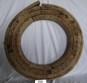
 Flagstaff Hill Maritime Museum and Village
Equipment - Lifebuoy, late 19th to early 20th century
... that would be carried on vessels in the late 19th and early 20th... that has required aeroplanes and water going-vessels to carry life ...This lifebuoy is part of the lifesaving equipment that would be carried on vessels in the late 19th and early 20th century. The strips of cork wood have been joined together to make the ring shape. A lifebuoy, or life-preserver, is used as a buoyancy device to keep a person afloat in the. It is usually connected by a rope to a person in a safe area such a nearby vessel or on shore. The lifebuoy is thrown to a person in distress in the water, allowing the rescuer to pull the person to safety. The lifebuoy is a made from a buoyant material such as cork or rubber and is usually covered with canvas for protection and to make it easy to grip. The first use of life saving devices in recent centuries was by the Nordic people, who used light weight wood or cork blocks to keep afloat. From the early 20th century Kapok fibre was used as a filling for buoys. Light weight balsa wood was used as a filler after WW1. In 1928 Peter Markus invented and patented the first inflatable life-preserver. By WW2 foam was combined with Kapok. Laws were passed over time that has required aeroplanes and water going-vessels to carry life-preservers on board. The lifebuoy is an example of equipment carried on vessels in the late 19th and early 20th century to help preserve life. There were many lives lost in Australia’s colonial period, particularly along the coast of South West Victoria.Lifebuoy, round cork object with no covering. flagstaff hill, warrnambool, shipwrecked-coast, flagstaff-hill, flagstaff-hill-maritime-museum, maritime-museum, shipwreck-coast, flagstaff-hill-maritime-village, life rings, lifebuoy, safety ring, life-saving buoy, ring buoy, life preserver, personal floating device, floatation device, safety equipment -
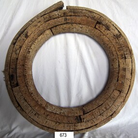
 Flagstaff Hill Maritime Museum and Village
Equipment - Lifebuoy, late 19th to early 20th century
... that would be carried on vessels in the late 19th and early 20th... that has required aeroplanes and water going-vessels to carry life ...This lifebuoy is part of the lifesaving equipment that would be carried on vessels in the late 19th and early 20th century. The strips of cork wood have been joined together to make the ring shape. A lifebuoy, or life-preserver, is used as a buoyancy device to keep a person afloat in the. It is usually connected by a rope to a person in a safe area such a nearby vessel or on shore. The lifebuoy is thrown to a person in distress in the water, allowing the rescuer to pull the person to safety. The lifebuoy is a made from a buoyant material such as cork or rubber and is usually covered with canvas for protection and to make it easy to grip. The first use of life saving devices in recent centuries was by the Nordic people, who used light weight wood or cork blocks to keep afloat. From the early 20th century Kapok fibre was used as a filling for buoys. Light weight balsa wood was used as a filler after WW1. In 1928 Peter Markus invented and patented the first inflatable life-preserver. By WW2 foam was combined with Kapok. Laws were passed over time that has required aeroplanes and water going-vessels to carry life-preservers on board. The lifebuoy is an example of equipment carried on vessels in the late 19th and early 20th century to help preserve life. There were many lives lost in Australia’s colonial period, particularly along the coast of South West Victoria.Lifebuoy; round, cork filling of lifebuoy. The nails joining the layers are visible. flagstaff hill, warrnambool, shipwrecked-coast, flagstaff-hill, flagstaff-hill-maritime-museum, maritime-museum, shipwreck-coast, flagstaff-hill-maritime-village, life rings, lifebuoy, safety ring, life-saving buoy, ring buoy, life preserver, personal floating device, floatation device, safety equipment -
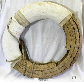
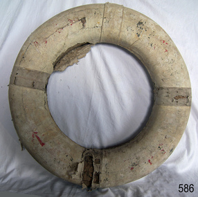
 Flagstaff Hill Maritime Museum and Village
Equipment - Lifebuoy, late 19th to early 20th century
... that would be carried on vessels in the late 19th and early 20th... that has required aeroplanes and water going-vessels to carry life ...This lifebuoy is part of the lifesaving equipment that would be carried on vessels in the late 19th and early 20th century. The strips of cork wood have been joined together to make the ring shape. A lifebuoy, or life-preserver, is used as a buoyancy device to keep a person afloat in the. It is usually connected by a rope to a person in a safe area such a nearby vessel or on shore. The lifebuoy is thrown to a person in distress in the water, allowing the rescuer to pull the person to safety. The lifebuoy is a made from a buoyant material such as cork or rubber and is usually covered with canvas for protection and to make it easy to grip. The first use of life saving devices in recent centuries was by the Nordic people, who used light weight wood or cork blocks to keep afloat. From the early 20th century Kapok fibre was used as a filling for buoys. Light weight balsa wood was used as a filler after WW1. In 1928 Peter Markus invented and patented the first inflatable life-preserver. By WW2 foam was combined with Kapok. Laws were passed over time that has required aeroplanes and water going-vessels to carry life-preservers on board. The lifebuoy is an example of equipment carried on vessels in the late 19th and early 20th century to help preserve life. There were many lives lost in Australia’s colonial period, particularly along the coast of South West Victoria.Lifebuoy, round cork filling inside white canvas cover with four reinforced bands. Four ropes are attached.flagstaff hill, warrnambool, shipwrecked-coast, flagstaff-hill, flagstaff-hill-maritime-museum, maritime-museum, shipwreck-coast, flagstaff-hill-maritime-village, life rings, lifebuoy, safety ring, life-saving buoy, ring buoy, life preserver, personal floating device, floatation device, safety equipment -
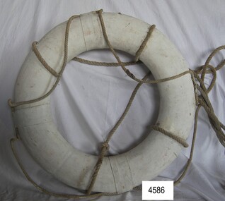
 Flagstaff Hill Maritime Museum and Village
Equipment - Lifebuoy
... that would be carried on vessels in the late 19th and early 20th... equipment that would be carried on vessels in the late 19th ...This lifebuoy is part of the lifesaving equipment that would be carried on vessels in the late 19th and early 20th century. The strips of cork wood have been joined together to make the ring shape. The broad arrow symbol indicates that it was once the property of the British or Australian defence force. A lifebuoy, or life-preserver, is used as a buoyancy device to keep a person afloat in the. It is usually connected by a rope to a person in a safe area such a nearby vessel or on shore. The lifebuoy is thrown to a person in distress in the water, allowing the rescuer to pull the person to safety. The lifebuoy is a made from a buoyant material such as cork or rubber and is usually covered with canvas for protection and to make it easy to grip. The first use of life saving devices in recent centuries was by the Nordic people, who used light weight wood or cork blocks to keep afloat. From the early 20th century Kapok fibre was used as a filling for buoys. Light weight balsa wood was used as a filler after WW1. In 1928 Peter Markus invented and patented the first inflatable life-preserver. By WW2 foam was combined with Kapok. Laws were passed over time that has required aeroplanes and water going-vessels to carry life-preservers on board. The lifebuoy is an example of equipment carried on vessels in the late 19th and early 20th century to help preserve life. There were many lives lost in Australia’s colonial period, particularly along the coast of South West Victoria. The lifebuoy was once the property of the British or Australian defence force.Lifebuoy, round cork object with canvas wrapped around it and rope attached to one side. Broad arrow mark and other red marks indecipherable. Painted white.Symbol of broad arrow. indecipherable markings.flagstaff hill, warrnambool, shipwrecked-coast, flagstaff-hill, flagstaff-hill-maritime-museum, maritime-museum, shipwreck-coast, flagstaff-hill-maritime-village, life rings, lifebuoy, safety ring, life-saving buoy, ring buoy, life preserver, personal floating device, floatation device, safety equipment, government lifebuoy, broad arrow -
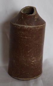 Buninyong Visitor Information Centre
Container - Ceramic bottle, K. Evans Potteries of Nottingham, Brown glazed stoneware bottle
... , such as carrying water, ale, mead, or wine. Stew jars and drinking vessels..., such as carrying water, ale, mead, or wine. Stew jars and drinking vessels ...Made in Nottingham, England by K. Evans. K. Evans Potteries in Nottingham has an intriguing history. During the construction of the Manchester, Sheffield & Lincolnshire Railway Company’s new London line (now known as the Great Central) through Nottingham, several objects of antiquarian interest were discovered. Among these treasures was an ancient pottery kiln, buried for centuries beneath the soft yellow Bunter sandstone rock that forms a significant part of the city’s foundation. The excavation took place near the point where Parliament Street intersects the railway, at a depth of ten to twelve feet below the original surface. The credit for rescuing many of these pottery fragments from destruction goes to Mr. C. B. Wright, of the late firm I. & I. C. Wright & Co., Bankers. His dedication and ingenuity allowed him to piece together broken parts, sometimes assembling as many as thirty or forty fragments to form a single complete specimen. These pottery pieces provide a fascinating glimpse into the past. Here are some details about the pottery found at K. Evans Potteries: Material: The pottery is made of coarse, reddish-brown clay. Construction: Evidence suggests that the potter’s wheel was used in their creation. Ornamentation: The vessels lack decorative patterns, except for indented or grooved handles. These handles exhibit a crude attempt at foliation, with the potter’s thumb leaving its mark. Function: The pottery likely served practical purposes, such as carrying water, ale, mead, or wine. Stew jars and drinking vessels were also part of this collection. This discovery remains almost unique, and its age continues to intrigue local antiquaries. While theories about its origin are scarce, the K. Evans Potteries offer a fascinating glimpse into Nottingham’s ancient craftsmanship. Cylindrical brown pottery jar (Bottle) with broken neck section. Uneven and work appearance of glazed surface.'... Stone bottles. K. Evans. ...Potteries of Nottingham'ceramics, pottery, bottles -
 Bendigo Historical Society Inc.
Photograph - Historical Society Field Trip to the Springs at Sedgwick, Abt 2009
... water channels, aqueducts, syphons and tunnels to carry water... water channels, aqueducts, syphons and tunnels to carry water ...The Phil Wilkin Collection contains a series of 11 Items. The related items can be found by clicking on the reference link below. The following history of the Young family and their descendants who lived at the Springs is provided by Phil Wilkin. His Great Grandparents were Frances Young and August Wirth. Phil has also provided notes on the Wilkin Family and some history of the gold mining in Sedgwick. Frances Young's parents Joseph and Margaret Young owned the property called "The Old Place, Preston Vale or Wellington Flat" at Sedgwick near the Springs. Joseph Young owned and Managed the Standard Brewery which was located at Campbells Creek during the late 1800’s early 1900’s. Joseph and Margaret are buried in the Harcourt cemetery. In 1880 August Wirth lived at Mosquito Creek (Lake Eppalock, Victoria) when he married Frances Young. In 1902 they moved to part of Joseph Young's property. They milked cows and sold cattle for a living. One of their children Charles Wirth (Phil Wilkin's Grandfather) bought the land in 1935 after his parents had died. Charles Wirth was a councillor and also was president of the Shire of Strathfieldsaye. The "Old Place" was part of the property owned by members of the family. The old house at the Springs was burnt out by bushfire in January 1944 and much of the stonework was later vandalized by campers. The original Coliban Water Works were designed in 1863 by the Irish engineer Joseph Brady. The system included 70 kilometres of open water channels, aqueducts, syphons and tunnels to carry water (by gravity) from the Coliban River at Malmsbury, north to Castlemaine and Bendigo. Sedgwick is a locality in Central Victoria, Australia. It is located in the City of Greater Bendigo. Facilities include a public hall that opened in 1958 and CFA Rural fire station. It was named Upper Emu Creek until 1901 when it was renamed as Sedgwick after British geologist Adam Sedgwick.Twenty nine photos taken on a field trip by the Bendigo Historical Society to "The Springs" on the main Coliban water channel from Malmsbury to the Sandhurst Reservoir in Bendigo. The water race descends through a concrete chute, and continues sharply around the contour of the hills. Once it descended into a syphon across the gully. The are 182 photos in this series and can be found at 8683.1 to 8683.11. The series also includes photos of the surrounding farming land and the remains of an old house. There are also some notes on the pioneers of the district.history, bendigo, coliban water, joseph brady, irrigation, the springs, sedgwick -
 Bendigo Historical Society Inc.
Photograph - Historical Society Field Trip to the Springs at Sedgwick, Abt 2009
... water channels, aqueducts, syphons and tunnels to carry water... water channels, aqueducts, syphons and tunnels to carry water ...The Phil Wilkin Collection contains a series of 11 Items. The related items can be found by clicking on the reference link below. The following history of the Young family and their descendants who lived at the Springs is provided by Phil Wilkin. His Great Grandparents were Frances Young and August Wirth. Phil has also provided notes on the Wilkin Family and some history of the gold mining in Sedgwick. Frances Young's parents Joseph and Margaret Young owned the property called "The Old Place, Preston Vale or Wellington Flat" at Sedgwick near the Springs. Joseph Young owned and Managed the Standard Brewery which was located at Campbells Creek during the late 1800’s early 1900’s. Joseph and Margaret are buried in the Harcourt cemetery. In 1880 August Wirth lived at Mosquito Creek (Lake Eppalock, Victoria) when he married Frances Young. In 1902 they moved to part of Joseph Young's property. They milked cows and sold cattle for a living. One of their children Charles Wirth (Phil Wilkin's Grandfather) bought the land in 1935 after his parents had died. Charles Wirth was a councillor and also was president of the Shire of Strathfieldsaye. The "Old Place" was part of the property owned by members of the family. The old house at the Springs was burnt out by bushfire in January 1944 and much of the stonework was later vandalized by campers. The original Coliban Water Works were designed in 1863 by the Irish engineer Joseph Brady. The system included 70 kilometres of open water channels, aqueducts, syphons and tunnels to carry water (by gravity) from the Coliban River at Malmsbury, north to Castlemaine and Bendigo. Sedgwick is a locality in Central Victoria, Australia. It is located in the City of Greater Bendigo. Facilities include a public hall that opened in 1958 and CFA Rural fire station. It was named Upper Emu Creek until 1901 when it was renamed as Sedgwick after British geologist Adam Sedgwick.Twenty five photos taken on a field trip by the Bendigo Historical Society to "The Springs" on the main Coliban water channel from Malmsbury to the Sandhurst Reservoir in Bendigo. The water race descends through a concrete chute, and continues sharply around the contour of the hills. Once it descended into a syphon across the gully. The are 182 photos in this series and can be found at 8683.1 to 8683.11. The series also includes photos of the surrounding farming land and the remains of an old house. There are also some notes on the pioneers of the district.history, bendigo, coliban water, joseph brady, irrigation, the springs, sedgwick -
 Bendigo Historical Society Inc.
Photograph - Historical Society Field Trip to the Springs at Sedgwick, Abt 2009
... water channels, aqueducts, syphons and tunnels to carry water... water channels, aqueducts, syphons and tunnels to carry water ...The Phil Wilkin Collection contains a series of 11 Items. The related items can be found by clicking on the reference link below. The following history of the Young family and their descendants who lived at the Springs is provided by Phil Wilkin. His Great Grandparents were Frances Young and August Wirth. Phil has also provided notes on the Wilkin Family and some history of the gold mining in Sedgwick. Frances Young's parents Joseph and Margaret Young owned the property called "The Old Place, Preston Vale or Wellington Flat" at Sedgwick near the Springs. Joseph Young owned and Managed the Standard Brewery which was located at Campbells Creek during the late 1800’s early 1900’s. Joseph and Margaret are buried in the Harcourt cemetery. In 1880 August Wirth lived at Mosquito Creek (Lake Eppalock, Victoria) when he married Frances Young. In 1902 they moved to part of Joseph Young's property. They milked cows and sold cattle for a living. One of their children Charles Wirth (Phil Wilkin's Grandfather) bought the land in 1935 after his parents had died. Charles Wirth was a councillor and also was president of the Shire of Strathfieldsaye. The "Old Place" was part of the property owned by members of the family. The old house at the Springs was burnt out by bushfire in January 1944 and much of the stonework was later vandalized by campers. The original Coliban Water Works were designed in 1863 by the Irish engineer Joseph Brady. The system included 70 kilometres of open water channels, aqueducts, syphons and tunnels to carry water (by gravity) from the Coliban River at Malmsbury, north to Castlemaine and Bendigo. Sedgwick is a locality in Central Victoria, Australia. It is located in the City of Greater Bendigo. Facilities include a public hall that opened in 1958 and CFA Rural fire station. It was named Upper Emu Creek until 1901 when it was renamed as Sedgwick after British geologist Adam Sedgwick.Twenty six photos taken on a field trip by the Bendigo Historical Society to "The Springs" on the main Coliban water channel from Malmsbury to the Sandhurst Reservoir in Bendigo. The water race descends through a concrete chute, and continues sharply around the contour of the hills. Once it descended into a syphon across the gully. The are 182 photos in this series and can be found at 8683.1 to 8683.11. The series also includes photos of the surrounding farming land and the remains of an old house. There are also some notes on the pioneers of the district.history, bendigo, coliban water, joseph brady, irrigation, the springs, sedgwick -
 Bendigo Historical Society Inc.
Photograph - Historical Society Field Trip to the Springs at Sedgwick, Abt 2009
... water channels, aqueducts, syphons and tunnels to carry water... water channels, aqueducts, syphons and tunnels to carry water ...The Phil Wilkin Collection contains a series of 11 Items. The related items can be found by clicking on the reference link below. The following history of the Young family and their descendants who lived at the Springs is provided by Phil Wilkin. His Great Grandparents were Frances Young and August Wirth. Phil has also provided notes on the Wilkin Family and some history of the gold mining in Sedgwick. Frances Young's parents Joseph and Margaret Young owned the property called "The Old Place, Preston Vale or Wellington Flat" at Sedgwick near the Springs. Joseph Young owned and Managed the Standard Brewery which was located at Campbells Creek during the late 1800’s early 1900’s. Joseph and Margaret are buried in the Harcourt cemetery. In 1880 August Wirth lived at Mosquito Creek (Lake Eppalock, Victoria) when he married Frances Young. In 1902 they moved to part of Joseph Young's property. They milked cows and sold cattle for a living. One of their children Charles Wirth (Phil Wilkin's Grandfather) bought the land in 1935 after his parents had died. Charles Wirth was a councillor and also was president of the Shire of Strathfieldsaye. The "Old Place" was part of the property owned by members of the family. The old house at the Springs was burnt out by bushfire in January 1944 and much of the stonework was later vandalized by campers. The original Coliban Water Works were designed in 1863 by the Irish engineer Joseph Brady. The system included 70 kilometres of open water channels, aqueducts, syphons and tunnels to carry water (by gravity) from the Coliban River at Malmsbury, north to Castlemaine and Bendigo. Sedgwick is a locality in Central Victoria, Australia. It is located in the City of Greater Bendigo. Facilities include a public hall that opened in 1958 and CFA Rural fire station. It was named Upper Emu Creek until 1901 when it was renamed as Sedgwick after British geologist Adam Sedgwick.Twenty five photos taken on a field trip by the Bendigo Historical Society to "The Springs" on the main Coliban water channel from Malmsbury to the Sandhurst Reservoir in Bendigo. The water race descends through a concrete chute, and continues sharply around the contour of the hills. Once it descended into a syphon across the gully. The are 182 photos in this series and can be found at 8683.1 to 8683.11. The series also includes photos of the surrounding farming land and the remains of an old house. There are also some notes on the pioneers of the district.history, bendigo, coliban water, joseph brady, irrigation, the springs, sedgwick -
 Bendigo Historical Society Inc.
Photograph - The Young and Wirth Families at Preston Vale, near the Springs Sedgwick, 1880s-1900s
... water channels, aqueducts, syphons and tunnels to carry water... water channels, aqueducts, syphons and tunnels to carry water ...The Phil Wilkin Collection contains a series of 11 Items. The related items can be found by clicking on the reference link below. The following history of the Young family and their descendants who lived at the Springs is provided by Phil Wilkin. His Great Grandparents were Frances Young and August Wirth. Phil has also provided notes on the Wilkin Family and some history of the gold mining in Sedgwick. Frances Young's parents Joseph and Margaret Young owned the property called "The Old Place, Preston Vale or Wellington Flat" at Sedgwick near the Springs. Joseph Young owned and Managed the Standard Brewery which was located at Campbells Creek during the late 1800’s early 1900’s. Joseph and Margaret are buried in the Harcourt cemetery. In 1880 August Wirth lived at Mosquito Creek (Lake Eppalock, Victoria) when he married Frances Young. In 1902 they moved to part of Joseph Young's property. They milked cows and sold cattle for a living. One of their children Charles Wirth (Phil Wilkin's Grandfather) bought the land in 1935 after his parents had died. Charles Wirth was a councillor and also was president of the Shire of Strathfieldsaye. The "Old Place" was part of the property owned by members of the family. The old house at the Springs was burnt out by bushfire in January 1944 and much of the stonework was later vandalized by campers. The original Coliban Water Works were designed in 1863 by the Irish engineer Joseph Brady. The system included 70 kilometres of open water channels, aqueducts, syphons and tunnels to carry water (by gravity) from the Coliban River at Malmsbury, north to Castlemaine and Bendigo. Sedgwick is a locality in Central Victoria, Australia. It is located in the City of Greater Bendigo. Facilities include a public hall that opened in 1958 and CFA Rural fire station. It was named Upper Emu Creek until 1901 when it was renamed as Sedgwick after British geologist Adam Sedgwick.Thirty Four Photos of Joseph Young's property near "The Springs" on the main Coliban water channel from Malmsbury to the Sandhurst Reservoir in Bendigo. This item contains family history of Joeph's descendant Charles Wirth, who was a councillor for the Shire of Strathfieldsaye. The water race descends through a concrete chute, and continues sharply around the contour of the hills. Once it descended into a syphon across the gully. The are 182 photos in this series and can be found at 8683.1 to 8683.11. The series also includes photos of the surrounding farming land and the remains of an old house. There are also some notes on the pioneers of the district.history, bendigo, coliban water, joseph brady, irrigation, the springs, sedgwick, charles wirth, preston vale, joseph and margaret young, standard brewery campbells creek harcourt, phil wilkin collection