Showing 1122 items
matching waterway
-
 Lakes Entrance Historical Society
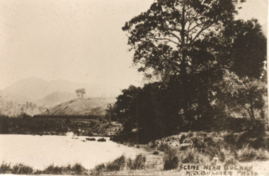
Postcard - Buchan Victoria, H D Bulmer, 1915 c
Sepia toned copy of postcard showing waterway with mountains in distance at Buchan Victoria. Also a second identical photographScene near Buchanagriculture, topography -
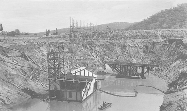 El Dorado Museum Association Inc.
Photograph (item) - Digital Image
Cocks Pioneer Barge with new pump and punt. Cocks Pioneer Electric Gold & Tin Mine Company was formed in 1899. The company's first power station, located at the eastern end of the valley began operating with its 340 Kilowatt steam-powered generator. By 1909, from 2,500,000 cubic yards worked, reported recovery was 17,284 ounces of gold and 224 tons of tin ore. By 1909, Cocks Pioneer’s power plant had become inadequate and uneconomical. The barge was floated downstream about a mile, but lost time caused the operations to cease. Following testing, a new mine was established by diverting Reid's Creek at a cost of £25,000. Settling dams were built, one of which held 1,935,900 cubic feet. Sold earth banks, built against a wall of stringy bark saplings constructed and laced with vertical props, were built. In 1914, the company was reformed as Cock’s Pioneer Gold and Tin Mines NL, another power station was constructed at the western end of the township, near the junction of Clear and Reid's Creeks. From 6,800,000 cubic yards of material processed, the returns were 64,397 ounces of gold and 855 ton of tin. Cocks Pioneer mine then moved the barge downs stream and continued sluicing. In 1929 Cocks Pioneer Electric Gold and Tin Mining Company ceased operations due to a drop in values. Cock’s Pioneer Gold and Tin Mines NL carried on large-scale hydraulic sluicing operations until 1941. mines, mining, gold, tin, gold mining, tin mining, watercraft, punt, boats, men, cocks pioneer, el dorado, eldorado -
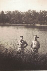 Linton and District Historical Society Inc
Photograph, Ivan and Lyle Grigg
Small black and white image of two men standing at the edge of a waterway. Believed to be Linton Reservoir, Mortchup Road, Linton.ivan grigg, lyle grigg -
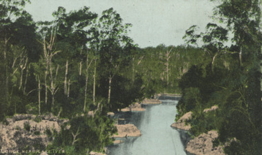 Lakes Entrance Historical Society
Postcard - Lake Tyers, E.J.B. Series, 1905c
Also a black and white postcard of Lake Tyers Gippsland number 03823.1 size 9 x 13.5 cm purchased from B RocheTinted postcard of a gorge showing a narrow waterway between rocky banks and thick vegetation near Lake Tyers VictoriaGorge near Lake Tyersforest, waterways -
 Lakes Entrance Historical Society
Postcard - North Arm Lakes Entrance Victoria, 1920 c
Also another black and white postcard of North Arm Lakes Entrance showing a large bight 05278.1Black and white postcard showing calm waterway betweem steep banks at the entrance to the North Arm Lakes Entrance VictoriaBackwater Cunninghame S Vogt Photowaterways -
 Lakes Entrance Historical Society
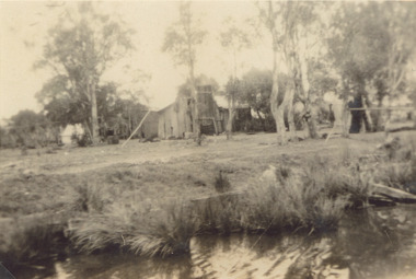
Photograph, Edie Jemmeson, fishermans cottage Lake Tyers Victoria c1900, 1900 c
Black and white photograph of fishermans cottage in a rural setting beside a waterway, frame for nets in foreground. Lake Tyers Victoriasettlement, fishing, waterways -
 Lakes Entrance Historical Society
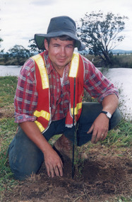
Photograph, Lakes Post Newspaper, 1994
Colour photograph of Paul Broome planting a tree beside a waterway during catchment authority revegitation project East Gippsland Victoriarevegitation -
 Lakes Entrance Historical Society
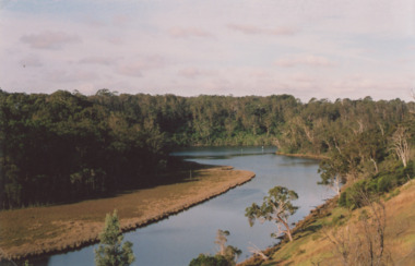
Photograph - North Arm Lakes Entrance, M Holding, 1/03/2009 12:00:00 AM
Colour photograph showing large bay of North Arm and calm waterway between steep timbered banks Lakes Entrance Victoria tourism, houses, waterways, lakes entrance -
 Lakes Entrance Historical Society
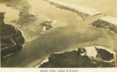
Postcard - Aerial view Lakes Entrance, H D Bulmer, 1922 c
Image clearly shows new alignment of Princes Highway around Jemmys Point and part of the original high road to the first bend above North Arm BridgeBlack and white postcard aerial view of the western area of the town, Bullock Island and Snake Island and waterways Lakes Entrance VictoriaAerial View Lakes Entrancewaterways, islands, township -
 Glenelg Shire Council Cultural Collection
Photograph - Photograph - Rural Scene two men standing on bank of waterway, n.d
Black and white photo attached to heavy card. Lighter area around print. Rural scene, two men standing on bank of waterway.Back: 'largo/fargo Class 1' - black ink -
Whitehorse Historical Society Inc.
Document, Open space between Yarran Dheran and Schwerkolt Cottage, 2001
Report of an open space assessment by Melbourne Parks and Waterways land between Yarran Dheran and Schwerkolt Cottage.Report of an open space assessment by Melbourne Parks and Waterways land between Yarran Dheran and Schwerkolt Cottage. Council Paper PROP/016781Report of an open space assessment by Melbourne Parks and Waterways land between Yarran Dheran and Schwerkolt Cottage. yarran dheran, nunawading and district historical society inc., schwerkolt cottage -
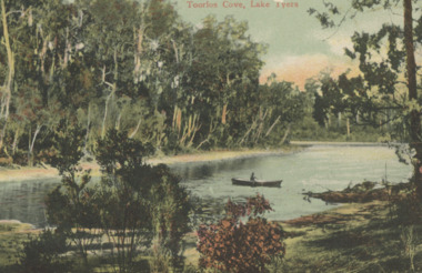 Lakes Entrance Historical Society
Postcard - Lake Tyers, 1905c
Tinted postcard of Toorloo Cove showing secluded waterway between thickly timbered banks rowing boat on water Lake Tyers VictoriaToorloo Cove Lake Tyerswaterways, vegetation, catchments -
 Orbost & District Historical Society
black and white photograph, late 19th - early 20th century
In the late 1800's early 1900's transporting goods by road was difficult and at times impossible because roads as thoroughfares did not exist.The means of travelling along the roads in the 1800's was by bullock wagon, horse pulled dray, pack horse or simply by foot. This is a pictorial record of transport in the mid 18th - early 19th century. Pack horses were vital for the delivery of goods, responding to emergencies as they could travel in country inaccessible to larger horse - drawn carts or wagons.A black / white photograph on a black buff card. It is of a group of pack horses being guided across a waterway with a man on horseback on either side of the river.transport pack-horses -
Glenelg Shire Council Cultural Collection
Photograph - Photograph - Rural scene, n.d
Black and white photo mounted on dark grey card, with lighter border around print. Rural scene, waterway, derelict fence, gums, reeds.Back: 'View near Portland' largo/fargo class 1 - pen -
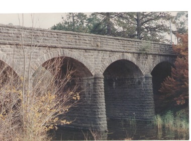 Sunbury Family History and Heritage Society Inc.
Photograph, Bulla Bridge, c 1980s
The bridge in the photograph is the bluestone bridge at Bulla which spans the Deep Creek, a tributary of the Maribyrnong River. It was built in 1869 and replaced a ford crossing which was built further downstream. Many of the buildings and structures in the area were built from bluestone which is in abundance throughout this volcanic area.This bridge is one of many similar structures built across Western Victoria where the bluestone volcanic rock was found in abundance.A coloured close - up photograph of a four-arched blue stone bridge spanning a waterway. Some greenery is visible on either side of the bridge and above it. bulla bridge, bluestone, bridges, deep creek. -
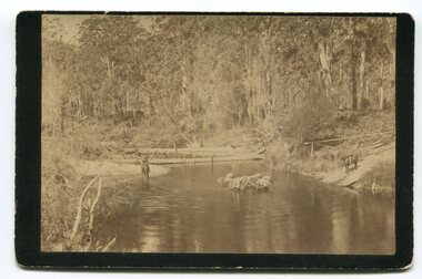
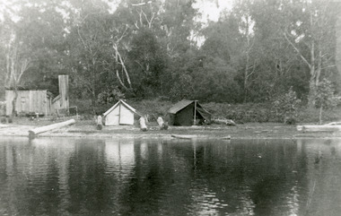 Lakes Entrance Historical Society
Photograph - Lake Tyers, Phillips Miss L, 1900 c
Miss Phillips album donated by R ClarkBlack and white photograph of a fishermen's camp at Lake Tyers, showing two tents and a timber hut on shore of calm waterway. Lake Tyers Victoriawaterways, camp, fishing -
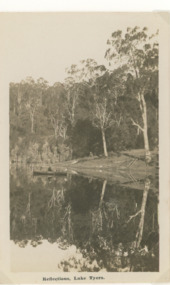 Lakes Entrance Historical Society
Postcard - Lake Tyers
Black and white postcard of waterway showing rowing boat on lake, steep bank in background timber reflections in calm water Lake Tyers VictoriaReflections Lake Tyerswaterways, forest, boating -
 Lakes Entrance Historical Society
Photograph - Dredge Sandpiper, L E Tidy Town Committee, Lakes Entrance Victoria, 1994 c
Colour photograph of the entrance sand buildup Kennet Island in waterway dredge Sandpiper working at southwest corner of Bullock Island Lakes Entrance Victoriadredges, waterways, islands -
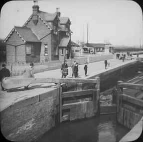 Federation University Historical Collection
Photograph - Glass Plate, Henry Sutton, Hertford Lock by Henry Sutton, c1891
Henry Sutton was born in Ballarat into the musical Sutton Family. He is known as an important Australian inventor. Photograph of Hertford Lock. lockkeepers house. A lock is a device used for raising and lowering boats, ships and other watercraft between stretches of water of different levels on river and canal waterways. Hertford Lock is situated on the River Lea on the eastern side of Hartham Common, Hertford in the English county of Hertfordshire. It is owned and managed by British Waterways and is the first lock of the River Lee Navigation.henry sutton, glass plates, photography, swans -
 Lakes Entrance Historical Society
Photograph - Maringa Creek, 1999
A sawmill was situated on the flat where the creek enters the lake, timber brought to the mill by horse drawn trolley on tramway beside creek.Colour photograph of Maringa Creek, Nungurner. looking towards the lake. Shows a waterway meandering amongst swampy flats and tree covered banks. Nungurner Victoriasawmills, tramway, waterways -
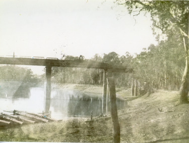
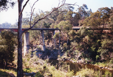 Lakes Entrance Historical Society
Photograph - Bridges, 1998
Re Heritage StudyColour photograph of the railway bridge over Boggy Creek, showing the bridge high above the waterway, rocky terrain and scrubby vegetation. Nowa Nowa, Victoria,bridges, waterways, transport -
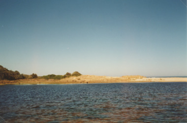 Lakes Entrance Historical Society
Photograph - Lake Bunga, M Holding, 1990c
Colour photograph of eastern shore near the entrance to ocean, the low area between upland and sand dune indicating the original waterway Lake Bunga Victoriatopography, waterfront -
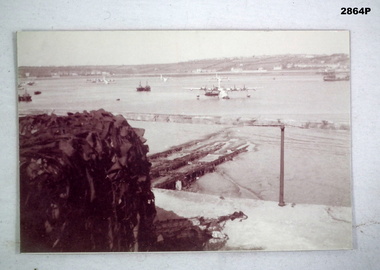
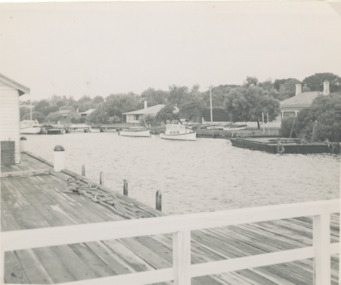 Lakes Entrance Historical Society
Photograph - New Works jetty Lakes Entrance Victoria
Black and white photograph of New Works jetty in foreground a government house and three cottages and three boats on other side of waterway, Lakes Entrance Victoriaboats and boating, jetties, waterways -
Lakes Entrance Historical Society
Book, Hawkins Richard, Creeks and Harbours of the Gippsland Lakes by Richard Hawkins, 1984
This book has been updated, all three updates in library VTMH 444.1, 444.2, 444.3. Last update 2000Survey and comprehensive boating guide to the creeks and harbours and waterways of the Gippsland Lakes Victoria at December 1984 contains maps, charts giving depth. Brief history of the region.waterways, boats and boating -
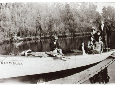 Lakes Entrance Historical Society
Photograph - Pindiewirra, 1930
Black and white photograph of the Pindiewirra, the delivery boat of Harbecks store, two men and five women on board on waterway which appears to be the North Arm, Lakes Entrance Victoria.businesses, transport, waterways, boats, genealogy -
 Lakes Entrance Historical Society
Photograph, 1940
Black and white photograph of a railway bridge over waterway on railway line at unknown location. Boat at edge of water has small load of log timbers across it. Victoriabridges, transport, vegetation -
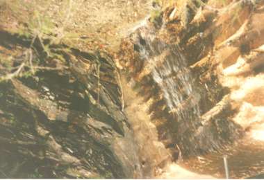 Lakes Entrance Historical Society
Photograph, Judy Davies, Cossticks Weir East Gippsland Victoria, 1990 c
Colour photograph of water spilling over the rock wall at Cossticks Weir East Gippsland Victoria. Also a colour photograph of waterway adjacent to Cossticks Weir East Gippslandbridges, waterways, weir's, topography -
 Bendigo Military Museum
Photograph - PHOTOGRAPH, AIRFORCE, c.WWII
Photo, black & white, showing a waterway with several Sunderland Air Craft moored, some boats & shipping. On left in foreground shows a large object covered in some sort of camouflage.photography-photographs, military history - air force, passchendaele barracks trust -
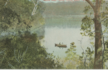 Lakes Entrance Historical Society
Postcard - Lake Tyers, Victoria Railways, 1905c
Also a tinted postcard titled Lake Tyers Victoria Railways Tourist Series number 03821.1 size 9 x 13.x cm purchased from B RoacheTinted postcard of Lotos Bay Nowa Nowa showing an open waterway surrounded by thick natural vegetation, rowing boat containing two people on lake. Lake Tyers VictoriaLotos Bay Nowa Nowa Lake Tyersforest, waterways -
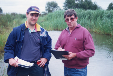 Lakes Entrance Historical Society
Photograph - Tambo Water Board, Lakes Post Newspaper, 1999
Colour photograph of Robin Minter Mitchell River Supervisor and Simon Robertson East Gippsland Catchment Authority Engineer beside a waterway during a training course East Gippsland Victoriawater resources